Bruce Lee -What a Strong El Niño Could Mean for the U.S.
.. wha? Bruce Lee uncertain?? .. lol, anyway, seems the operative word is "could" ..
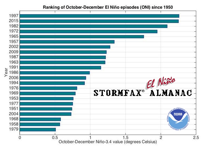
This year's El Niño could be among the strongest in history, but its effects could vary throughout the country.
NASA oceanographer Bill Patzert speaks about an El Nino weather system that could strike California in late fall or early winter on Thursday in Pasadena, Calif.
That has serious implications for the U.S., from California to New York to Ohio.
El Niño occurs when a shift in winds leads to warmer water in the eastern portion of the Pacific Ocean than usual. This typically and eventually brings rain from the Pacific to North America. Here's how:
The biggest question surrounding the current El Niño has been whether it will produce storms in California to help mitigate the drought in the area.
And while more rain could help alleviate the Golden State's drought, it can also bring with it mudslides and flooding in the case of extreme downpours.
This El Niño’s potential effects aren't limited to increased rain in California, though. In fact, there’s a reasonable chance plenty of other states could be seeing more precipitation as well this winter.
Meanwhile, other areas – like the Ohio Valley and Pacific Northwest – typically experience drier than average conditions during El Niño, according to NOAA. The effects aren't set in stone, however.
Winter precipitation (December-February) in 1982-83 and 1965-66 – two strong El Nino events .. https://www.climate.gov/news-features/blogs/enso/united-states-el-ni%C3%B1o-impacts-0 – compared to the 1981-2010 average. The winter of 1982-83 showed the "classic" wet signal that El Nino often brings to California, but the winter of 1965-66 did not.
El Niño can also affect the relative temperatures of the states. During an El Niño year, the northern portion of the U.S. typically experiences a winter that's slightly warmer than usual, while the South experiences the opposite.
“The one important element is that El Niño events are associated with large variability of outcome,” Anderson said. “People don’t associate as strongly the years when an El Niño event didn’t lead to a big outcome.”
This is a good one on the, thanks to algae/phytoplankton colors and "NASA's new Sea-viewing Wide Field-of-View Sensor (SeaWiFS)"
For years scientists have known that El Niño and La Niña change the levels of phytoplankton across the entire Pacific basin. During a normal year, winds gust at a steady rate from east to west across the Pacific and slowly blow the warm surface waters towards Australia and the Indonesian Archipelago. Over a period of time, these winds build up a "warm pool" of water in the western Pacific and leave the eastern Pacific relatively cool. This layer of warm water smothers any upwelling currents, which bring cool, nutrient-rich waters up from the depths of the sea (Njoku et al. 1993). Since phytoplankton can only survive in these nutrient-filled waters, the plants do not usually do well in the western Pacific and thrive in the eastern and central Pacific (Murtugudde et al. 1999).
Sea-viewing Wide Field-of-view (SeaWiFS) images of the Galapagos islands and surrounding waters from May 9, 1998 (top) and May 24, 1998 (bottom). The equatorial current shut down by El Niño reappeared over a period of days—indicated by the high concentrations of phytoplankton chlorophyll streaming to the west in the later image. (Courtesy Gene Feldman, SeaWiFS Project)
Esperance bushfires: firefighters battle through the night
"here's hoping it turns out not too bad for all of you over there ("Meteorologists say the current El Nino has already served to quiet the South Asian monsoon season.") (. . .) -- as you've just entered your spring and enter your peak heat in three months, in phase with it
and that in return we, in particular California, actually do get at least some real good part of what we do actually need (after the rather long mostly La Nina pattern which of course so helped set that up in the first place) -- within not many more weeks now, should, would expect/hope to, see at least some initial pattern-consistent jet flow set-ups, bringing at least some initial corresponding intrusions of moisture into California "
Date November 20, 2015 - 6:42AM
Staff writers
VIDEO
Esperance bushfire: community update
Nine News reporter Michael Genovese is on the ground at Esperance and is chatting with 6PR on the communities resilience.
Anna Winther from Norway dies, trying to save a horse Firefighter saves hundreds from inferno Esperance farmer dies after heroic act Lighting sparks deadly fires Locals open their homes to people WA community rallies around Esperance fire victims The fire in photos
bits
WA Farmers president Dale Park expects the losses from bushfires burning near Esperance are going to be horrific. Photo: Supplied
Esperance bushfires claim at least four lives Fires ravage Esperance as the town battles to cope with the destruction. Photo: Trevor Tasker
Farmers lose 'best ever crop' Nine News Perth Reporter Michael Genovese was at a community meeting in Esperance and said some farmers are still unable to head back to their land to asses the damage.
He said the resilience shown by those who received bad news was astonishing.
"I spoke to one lady whose family has been farming this land for more than 100 years and she said that this was the best crop ever", he said.
"For that to wiped away quiet literally up in smoke is so emotional."
Sydney weather: Record heat a chance as 'classic' set-up sears Australia's east
Date November 20, 2015 - 6:44AM
Peter Hannam Environment Editor, The Sydney Morning Herald
"We're in a scenario that a record is possible [on Friday]," Michael Logan, the bureau's severe weather manager for NSW, said. "We'll certainly go close."
If the sea breezes are kept at bay as expected, temperatures will be fairly uniform across the Sydney Basin. Bondi is expected to reach 41 degrees, as is Penrith, some 50 kilometres to the west.
A 40-plus reading would be enough to make it Sydney's hottest three-day spell in November in 79 years, Weatherzone said.
2015 will be hottest year on record — until 2016, WMO predicts
El Nino could help make 2016 even hotter than 2015
Thomson Reuters Posted: Nov 25, 2015 9:22 AM ET Last Updated: Nov 25, 2015 10:29 AM ET
Michel Jarraud, Secretary-General of the World Meteorological Organization (WMO) holds a graphic during the presentation of the five-year report on the climate from 2011- 2015 at the United Nations European headquarters in Geneva, Switzerland November 25, 2015. This year is set to be the hottest on record. (Denis Balibouse/Reuters)
This year will be the hottest on record and 2016 could be hotter due to the El Nino weather pattern, the World Meteorological Organization said on Wednesday, warning inaction on climate change could see temperatures rise by 6 degrees Celsius or more.
But decisions taken at a summit of world leaders in Paris starting on Monday could keep global temperature rises within 2 degrees Celsius (3.6 Fahrenheit) over pre-industrial times, a target set down in 2010 to try to prevent dangerous climate change.
"Yes, it's still possible to keep to the 2 degree target but the more we wait for action the more difficult it will be," WMO director-general Michel Jarraud told a news conference.
"You have scenarios assuming very strong decisions, very quick and sharp reduction of greenhouse gases, and you have other scenarios with business as usual, where you end up with predictions of additional warming of 5, 6 degrees, maybe even more. That will very much depend on the decisions (in Paris)."
Jarraud said El Nino may be responsible for 16-20 per cent of the rise and longer-term averages showed temperatures were rising regardless of El Nino or its cooling counterpart La Nina. FRANCE-WEATHER/HEATWAVE
People cool off from the heat at the Miroir d'Eau (Mirror of Water), a public art piece on the quay of the Garonne river, during a warm summer day in Bordeaux, southwestern France in June. A preliminary estimate based on data from January to October showed the global average surface temperature for 2015 was around 0.73 C above the 1961-1990 average of 14 C. (Regis Duvignau/Reuters)
El Nino, a naturally occuring weather pattern marked by warming sea-surface temperatures in the Pacific Ocean, causes extremes such as scorching weather, droughts and flooding around the world. Meteorologists expect El Nino to peak between October and January and to be one of the strongest on record.
A preliminary estimate based on data from January to October showed the global average surface temperature for 2015 was around 0.73 C above the 1961-1990 average of 14 C and around 1 C above the pre-industrial 1880-1899 period, the WMO said.
"This is all bad news for the planet," Jarraud said.
The years 2011-2015 have been the hottest five-year period on record, with temperatures about 0.57C (1.01 Fahrenheit) above the 1961-1990 reference period.
Global ocean temperatures were unprecedented during the period, and several land areas — including the continental United States, Australia, Europe, South America and Russia — broke temperature records by large margins.
"The world's ten warmest years have all occurred since 1998, with eight of them being since 2005," the WMO said.
Next year may be even warmer — levels of greenhouse gases in the atmosphere have risen to a new record every year for the past 30 years and El Nino is likely to continue into 2016.
"The year whose annual mean temperature is likely to be most strongly influenced by the current El Nino is 2016 rather than 2015," the WMO said.
Bushfires Victoria: Great Ocean Road towns evacuated as fire hits coast homes
Date December 26, 2015 - 5:16AM
Benjamin Preiss, Rania Spooner, Chloe Booker, Liam Mannix
VIDEO - 1:36 - Residents and visitors brace for Wye River bushfire As hot northerly winds spread fires across Victoria, residents and visitors along the Great Ocean Road are advised to stay alert and prepare accordingly. Vision courtesy ABC News 24.
Up to 60 houses could have been lost in the fires that have swept through the popular Surf Coast holiday towns of Wye River and Separation Creek.
Fifty-three houses were confirmed lost at 10pm Friday night, but CFA deputy incident controller Mark Gunnings said more property losses were possible as firefighters fought a 1700-hectare bushfire raging out of control in the Otways.
The fire at Wye River. Photo: Country Fire Authority
[IMAGE; can't reproduce] Three-year-old Madeline Vaucher enjoys a double strawberry gelato to beat the heat at Cottesloe Beach. Picture: Megan Powell /The West Australian.
This week’s heatwave has also equalled Perth’s longest run of 40C days.
A heatwave is defined as three or more days at or above 35C.
The last time Perth endured four consecutive days at 40C was exactly 83 years ago, from February 7-10 in 1933.
Tomorrow’s forecast maximum of 34C should bring an end to the heatwave, but Weather Bureau forecaster Neil Bennett said more pain was just around the corner.
[IMAGE] Marie Cochrane cools off with son Tui-Paul (4) at Hyde Park sister. Picture: Bill Hatto /The West Australian
The high pressure system that took so long to move east across the Great Australian Bight this week will soon be replaced by another lurking off the South West of WA.
“It’s a typical summer cycle but this week it stalled,” Mr Bennett said.
“We will have some temporary relief now, although mid-30s isn’t exactly cold.
“Then we’ll start to repeat the performance - possibly not back up to 40C but certainly getting close to it.”
 Market Data
  Markets