InvestorsHub Logo
icon url

StephanieVanbryce

04/25/11 11:34 PM

#137932 RE: F6 #137911

Vilonia AR Confirmed "Gone," Roads Ripped Out of Ground -- Tornado Outbreak Update x12

Mon Apr 25, 2011 at 12:45 PM PDT

weatherdude for Severe Weather Liveblog
http://www.dailykos.com/story/2011/04/25/970043/-Vilonia-AR-Confirmed-Gone,-Roads-Ripped-Out-of-GroundTornado-Outbreak-Updatex12?detail=hide

much more.


icon url

fuagf

04/26/11 3:03 AM

#137942 RE: F6 #137911

YT: EXTREME Tornado Video! April 26, 2009 - Northwest Oklahoma


http://www.youtube.com/watch?v=QrM0aecr1es

MIDWEST Multiple Ring Activity Vilonia Tornado 4/26/2011 1:13 AM


http://www.youtube.com/watch?v=sltkyFsHRTo
icon url

F6

04/26/11 6:54 PM

#137995 RE: F6 #137911

Particularly Dangerous Situation (PDS) Tornado Watch 215


http://www.spc.noaa.gov/products/watch/ww0215.html


===


Particularly Dangerous Situation (PDS) Tornado Watch 217


http://www.spc.noaa.gov/products/watch/ww0217.html


===


Current Convective Watches


http://www.spc.noaa.gov/products/watch/


===


Apr 26, 2011 2000 UTC Day 1 Convective Outlook


Probability of a tornado within 25 miles of a point.
Hatched Area: 10% or greater probability of EF2 - EF5 tornadoes within 25 miles of a point.


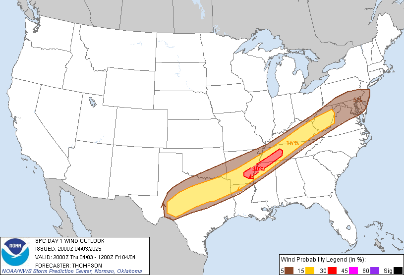
Probability of damaging thunderstorm winds or wind gusts of 50 knots or higher within 25 miles of a point.
Hatched Area: 10% or greater probability of wind gusts 65 knots or greater within 25 miles of a point.


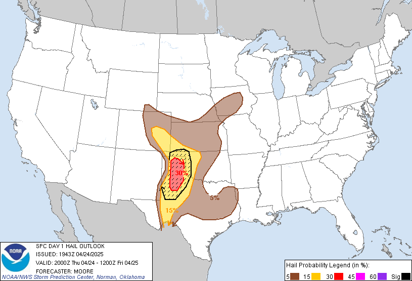
Probability of one inch diameter hail or larger within 25 miles of a point.
Hatched Area: 10% or greater probability of two inch diameter hail or larger within 25 miles of a point.


http://www.spc.noaa.gov/products/outlook/day1otlk.html


===


Severe Weather and Flash Flood Warnings
http://kamala.cod.edu/svr/


===


and see (items linked in) http://investorshub.advfn.com/boards/read_msg.aspx?message_id=62428465 and http://investorshub.advfn.com/boards/read_msg.aspx?message_id=59414424