"Att. blackhawks - Thanks to heavy rain, Australia’s environment scores a 7 out of 10 – but the future remains bleak [...] What’s more, in the winter and spring of 2021, parts of Australia also felt the effects .. dipole-and-why-is-it-so-important-164957" rel="nofollow noopener noreferrer ugc" target="_blank">https://theconversation.com/a-wet-winter-a-soggy-spring-what-is-the-negative-indian-ocean-dipole-and-why-is-it-so-important-164957 .. of a “negative Indian Ocean Dipole” – a little like the Indian Ocean’s version of La Niña that also brings rainier weather. "
17,430 views Jul 4, 2022
10 News First
Areas in Sydney’s North-West have been inundated for the fourth time, forcing tens of thousands from their homes right along our river system.
A man paddles his kayak through a flooded street at Windsor on the outskirts of Sydney, Australia, Tuesday, July 5, 2022. Hundreds of homes have been inundated in and around Australia’s largest city in a flood emergency that was impacting 50,000 people, officials said Tuesday. (AP Photo/Mark Baker)
CANBERRA, Australia — Parts of Australia’s largest city have been inundated by four major floods since March last year, leaving weary residents questioning how many times they can rebuild.
The latest disaster follows Sydney’s wettest-ever start to a year with dams overflowing and a sodden landscape incapable of absorbing more rain that must instead run into swollen waterways.
New South Wales state Premier Dominic Perrottet said government and communities need to adapt to major flooding becoming more common across Australia’s most populous state.
“To see what we’re seeing right across Sydney, there’s no doubt these events are becoming more common,” Perrottet said on Monday.
The bureau says two climate drivers led to Sydney’s flooding since Saturday.
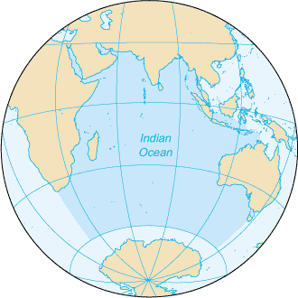
The flooding was influenced by the Indian Ocean Dipole,which refers to the difference in sea surface temperatures between the western and eastern Indian Ocean. In the negative phase, warmer waters concentrate near Australia, leading to above-average Southern Hemisphere winter–spring rainfall as more moisture is available to weather systems crossing the continent. The IOD has repeatedly dipped into its rain-bearing negative phase in the past month and is expected to stay negative within months.
A second influence was the positive Southern Annular Mode. The SAM refers to the non-seasonal, north-south movement of the strong westerly winds that blow almost continuously in the mid to high latitudes of the Southern Hemisphere. In the positive phase, the SAM directs more moisture-filled air than usual into eastern Australia, driving above-average rainfall and more east coast lows in winter.
During the latest rainfall event, extraordinarily warm waters off the Australian coast, 21 to 23 degrees Celsius (70 to 73 degrees Fahrenheit), provided extra energy and moisture to a deep trough and east coast low, concentrating heavy rainfall to one 24-hour period that started at 9 a.m. Saturday.
Several rain gauges in Sydney and its surrounding area set July or all-time records. ___
GEOGRAPHY AND DEMOGRAPHY
Much of Sydney’s rain drains into a river system prone to spilling over, but economic interests have largely blocked moves to mitigate flooding.
A 22,000-square-kilometer (8,500-square mile) rain catchment covering the Blue Mountains on Sydney’s western fringe and the city of 5 million’s western suburbs drain into the Hawkesbury-Nepean river system [https://en.wikipedia.org/wiki/Hawkesbury_River], which is the epicenter of some of the worst flooding.
The river system faces an extreme flood risk because gorges restrict the rivers’ seaward flow, often causing water to rapidly back up and spill across the floodplain after heavy rain, said Jamie Pittock, Australian National University professor of environment and society.
The Hawkesbury-Nepean Valley was home to 134,000 people and that population was projected to double by 2050 as Sydney’s population and real estate prices grow, he said.
“The potential economic returns from property development are a key driver for the lack of effective action to reduce flood risk,” Pittock said.
The state government wants to raise the wall of the Warragamba Dam, Sydney’s main reservoir, to reduce flooding in the valley.
Insert: Spillover July 2022
But some argue that raising the wall would control only half the floodwater and won’t prevent major flooding delivered by other rivers in the region, said Dale Dominey-Howes, Sydney University’s professor of hazards and disaster risk sciences.
In May 2017, the New South Wales state government released the Hawkesbury-Nepean Valley Flood Risk Management Strategy,[21] that proposed raising the height of Warragamba Dam by an additional 17 metres, using the Climate Change Mitigation Fund. It was claimed that this would reduce the risk of flooding to homes downstream along the Hawkesbury-Nepean river, that is the most at-risk region of Australia to devastating flooding, exacerbated by Global Warming.[22] A large public opposition campaign culminating in the GIVE A DAM movement began to protect the ecological, historical and Indigenous heritage of the additional area prone to flooding due to the raising of the dam wall. A significant portion of the land to be inundated is located within the Blue Mountains World Heritage Area designated by UNESCO, which stated that this status could be revoked if parts of the world heritage area were to be submerged.[citation needed] Activists also claim that the raising of the dam wall will give rise to additional developments downstream, which are currently not allowed to build on floodplains with a risk of a one-in-hundred-year flood. They also claim that any raising of the dam wall will be ineffective at flood mitigation, as the Warragamba River only contributes around 15% of water volume to the Hawkesbury-Nepean system. This issue has again been raised after the March 2021 Australian floods, with government ministers disagreeing on what needs to be done.[23][24 .. https://www.smh.com.au/politics/nsw/bitter-dispute-between-nsw-ministers-over-warragamba-dam-spilling-20210321-p57cnn.html ] https://en.wikipedia.org/wiki/Hawkesbury_River#Controversy
 Market Data
  Markets