

 Market Data
  Markets

Support: 888-992-3836
Copyright © 2023 InvestorsHub Inc.





Replies to post #8863 on Remote Dynamics Inc (RMTD)
Deloitte's ranking of 500 of the fastest growing technology, media, telecommunications, life sciences and clean technology companies in North America. Rankings are based on Percentage of fiscal year revenue growth from 2005 to 2009. Telogis grew 922.1 percent during this period.
Dave Cozzens, chief executive officer, Telogis, credits its advanced application development, enterprise focus and integrated location intelligence platform with the company's 922.1 percent revenue growth since 2005.
"Our continued growth is a testament to our people, our premium solutions, and to the proven ROI and operational advancements achieved through a seamless location-based platform," says Cozzens. "Hundreds of companies provide location services. We provide a
fully integrated management tool. Our comprehensive, scalable platform doesn't just log data on mobile resources - it shows managers and executives what to do with it and how to improve their business with it."
"Telogis and the other 2010 Technology Fast winners forged ahead in a challenging economic environment to realize exceptional growth," said Phil Asmundson, vice chairman and Deloitte's U.S. technology, media and telecommunications leader. "Deloitte commends Telogis for this impressive accomplishment."
Telogis ranked 163rd as a Technology Fast 500 award winner in 2009 and has appeared on the list four times since 2004. For additional detail on the Technology Fast 500 including selection and qualifying criteria, visit www.fast500.com ABOUT TELOGIS
ADAS data from NAVTEQ empowers application development that improves driver safety, fuel efficiency and driving performance.
ALISO VIEJO, Calif., - Telogis Inc., the platform for location intelligence, has integrated Advanced Driver Assistance Systems (ADAS) data from NAVTEQ® into its Telogis GeoBase geospatial platform. The platform uses NAVTEQ map data and integrates its Enhanced Geometry, Slope and Height, and Curvature products. This integration allows application developers to build advanced enterprise software solutions that improve driver safety, fuel efficiency and performance.
The Telogis GeoBase geospatial mapping engine goes beyond longitude and latitude to use topographical data that improves driver and asset safety. Incorporating this data into the platform allows for features such as adaptive/predictive cruise control, lane departure warnings, collision avoidance and speed adaptation technology to be built into routing/navigational applications.
"ADAS data brings a whole new depth to the Telogis GeoBase platform that allows enterprise telematics application developers to add functionality and performance that hasn't been available outside of consumer applications," says Newth Morris, president, Telogis. "Whether built by the OEM or added as an aftermarket platform, these capabilities will lower fleet operating costs and optimize routing/dispatching functions in almost all trucking applications."
ADAS data factors in terrain to determine the best route based on distance, height, curvature and slope to enable fuel efficient routes. Adaptive cruise control helps a truck engine to run at its optimal speed, which lowers fuel use and leads to substantial savings over time. Dispatchers and fleet managers will also be able to take terrain into account when calculating which truck/crew would be most efficiently routed to a delivery or site.
Integration of ADAS data with Telogis GeoBase allows for applications to be built in a way that ties the truck's operating systems to a broad set of variables to provide safe and optimized operation. This technology is also ideal for hybrid fleets to further improve engine performance and fuel efficiency. Applications built on the Telogis GeoBase platform include route optimization, fleet management, navigation, mapping, customized GIS overlays, geocoding, reverse geocoding and geofencing.
"NAVTEQ is committed to providing Telogis with technology that will advance the capabilities of the Telogis GeoBase platform." said Roy Kolstad, vice president, Enterprise Americas, NAVTEQ. "Telogis continues to demonstrate leadership and innovation in location intelligence. By implementing ADAS technology, developers using Telogis GeoBase can build solutions that enhance the driver's ability to react to the road environment and other vehicles."
ABOUT TELOGIS
Telogis Inc., the platform for location intelligence, is dedicated to enhancing the value of its customers' businesses through intelligent integration of location technology, information and services. Telogis was established in 2001 and is headquartered in Aliso Viejo, Calif., with offices in Europe and Latin America as well as development centers in Austin, Texas, and Christchurch, New Zealand. Telogis' products and services are used and distributed in more than 60 countries worldwide. To learn more about Telogis visit www.telogis.com or call toll free at 866-TELOGIS (866-835-6447).
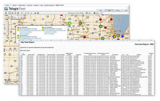
Aliso Viejo, CA - Telogis, Inc., the platform for location intelligence, introduces a new feature to its Telogis Fleet vehicle management application that compares fuel card use to actual location data: The Fuel Card Reconciliation Report. This new feature compares data that matches fuel card transactions and GPS-provided vehicle locations to verify authorized use of the card in one easy-to-read report. If a card is used without an approved vehicle within a specified range, that information is called out on the report to the fleet manager.
"We see this as another way for fleet managers in all industries to monitor and protect their mobile resources," says Jason Koch, president, Telogis Fleet. "Fuel expenses are always going to be part of the cost of doing business, but this fuel card report gives fleet managers a tool to help identify and end unauthorized expenditures. We use advanced spatial analysis to match the GPS history generated by Telogis to the fuel card purchase history generated by the customer's fuel card provider. This, combined with the ability to track and manage a fleet through one centralized platform, makes Telogis Fleet an important tool for the continued improvement of operational performance, cost and safety for fleets of all sizes."
Telogis Fleet is a real-time GPS fleet management solution that drives rapid return on investment for businesses of all sizes through improvement of productivity and operations. The application provides fleet managers and field resources with a comprehensive, scalable solution for fleet management, tracking and reporting. Industries served include utilities, telecommunications, OEM, construction, delivery, fleet leasing, food/beverage, pest control and waste management.
Aliso Viejo, CA - Telogis, Inc., the platform for location intelligence, announces today that its Telogis Fleet vehicle management solution has achieved MultiSpeak® Version 4 certification for interoperability with Milsoft Utility Solutions' DisSPatch® Outage Management System (OMS). MultiSpeak certification is a collaboration between the National Rural Electric Cooperative Association (NRECA) and leading software designers that supply the utility market to identify software products that work together without developing extensive or complicated interfaces.
By integrating Telogis Fleet with the DisSPatch OMS, utility customers will now visualize real-time location of field resources (both vehicles and assets) within Milsoft's DisSPatch Client Map. This allows dispatchers to better observe resource status and dispatch the closest technician with the most appropriate resources. It improves operational efficiency, outage management response time and overall productivity, saving both time and money.
"Integrating Telogis Fleet with a leading outage management system offers our utility customers additional levels of visibility and control over their mobile workforce, and increases the value of the location intelligence platform," says Jason Koch, president, Telogis Fleet. "Multispeak certification with Milsoft's DisSPatch solution improves workforce efficiency for utilities and better directs resources to where they are needed most."
"The integration with Telogis Fleet empowers our customers to make fast, accurate and critical decisions while in the field to ensure that power is restored as quickly and safely as possible," says Luis Malave, executive vice president and chief technology officer, Milsoft. "Milsoft is passionate about supporting MultiSpeak, as we feel that is the fastest and most cost-efficient way to deliver the value and usefulness of the software solutions that we deliver to our customers."
ABOUT TELOGIS
Telogis Inc., the platform for location intelligence, is dedicated to enhancing the value of its customers' businesses through intelligent integration of location technology, information and services. Telogis was established in 2001 and is headquartered in Aliso Viejo, Calif., with offices in Europe and Latin America as well as development centers in Austin, Texas and Christchurch, New Zealand. Telogis' products and services are used and distributed in more than 60 countries worldwide. To learn more about Telogis visit www.telogis.com or call toll free at 866-TELOGIS (866-835-6447).
ABOUT MILSOFT UTILITY SOLUTIONS
Milsoft has provided powerful software solutions for power system professionals in over 1,000 rural electric cooperatives, municipalities, educational institutions, and consultant offices in the United States and abroad. Milsoft offers a suite of software solutions including Engineering Analysis, Outage Management, Integrated Voice Response, Geospatial Information Systems and Field Engineering to optimize utility performance and efficiency. Milsoft has developed an outstanding reputation for delivering quality products, services and support to the electric utility industry for over two decades and continues to thrive on product innovation and superior customer support. To learn more, start here: www.milsoft.com.
ABOUT MULTISPEAK®
The MultiSpeak® Specification is an industry-wide software standard that facilitates interoperability of diverse business and automation applications used in electric utilities. It has been developed and maintained by a collaboration of NRECA and the 50 software vendors and consultants that are members of the MultiSpeak® Initiative.
www.multispeak.org
Aliso Viejo, Calif. - September 14, 2010: Telogis Inc., the platform for location intelligence, today signed a strategic partnership with Chilean GPS/GIS leaders Tastets Systems S.A. for the distribution, implementation and support of the Telogis Fleet location intelligence platform in Chile. Tastets, based in Providencia Santiago, works with more than 1,500 companies in Chile and abroad to provide fleet data via GPS technology. The partnership strengthens the ability of fleets to integrate the mobile workforce with key business processes and improve overall fleet efficiency, productivity and allocation.
"Chile has a sophisticated and diverse enterprise fleet industry," says Tarik Sarhan, director of sales and operations for South America, Telogis. "This partnership brings the depth of location-based intelligence provided by Telogis Fleet to Tastets' customers in industries ranging from mining to utilities and construction. Telogis' global experience matched with Tastets' rich knowledge and support of the local industry makes this the strongest telematics solution available in Chile."
"We evaluated software solutions throughout the world," said Diego Hurtado, director of Tastets Systems S.A. "In terms of breadth and sophistication of offerings, no other company approached Telogis. Our local presence combined with Telogis' software will raise the bar of fleet offerings in our region."
The partnership empowers Tastets to bring the Telogis Fleet platform to its small and medium enterprises as well as its national fleets, while both companies will work together to service multi-national clients. The deal further builds on Telogis' recent growth with enterprise fleets throughout Central and South America, including in Brazil, Mexico, Colombia and Venezuela.
Telogis' enterprise platform of location-based applications and services provides a comprehensive, end-to-end solution for companies looking to better manage, track and maximize productivity of their mobile resources. Industries served include utilities, telecommunications, OEM, construction, delivery, fleet leasing, food/beverage, pest control and waste management.
ABOUT TASTETS SYSTEMS S.A.
Tastets System S.A., is the Chilean leader in location intelligence and mobile resource management with more than 1,500 customers and 15,000 vehicles tracked. With over 13 years of experience, the company is recognized for its innovation, service and wide range of location-based products for the services, logistics and security industries. Tastets is headquartered in Santiago, Chile with customer support centers and certified installers nationwide. Visit www.gps.cl or call +562 4358712 for more information.
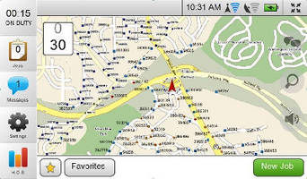
Telogis' next generation of fleet management software empowers fleet managers to integrate planning and operational data, field variables (weather, traffic) and location-based intelligence to make informed business decisions.
Editorial Highlights/Key Facts
o Integrates seamlessly with Telogis Route and Telogis Mobile to provide the most comprehensive telematics platform in the industry.
o Dynamic traffic and weather information improves routing, allocation and direction of field crews.
o Track/manage crews through Multiple Vehicle Histories: view current and historical data to track excessive congregation, speeding, etc.
o "What Happened Here?" accesses historical data within seconds to investigate field incidents and litigious claims.
o IFTA/IRP feed helps companies manage compliance by filing reports based on actual GPS data.
ALISO VIEJO, Calif., - Telogis, the platform for location intelligence, introduces Telogis Fleet 8: the industry's most reliable and scalable GPS fleet management software. Telogis' Software-as-a-Service (SaaS) GPS fleet management system drives rapid return on investment for fleets of all sizes through improved productivity and operational streamlining. Telogis Fleet 8 now incorporates dynamic traffic and weather data to allow fleet managers to make the most informed real-time routing and allocation decisions based on current conditions in the field.
Additional new components include an International Fuel Tax Agreement (IFTA)/International Registration Plan (IRP) data feed, Multiple Vehicle Histories, Streetside/Birds Eye View imaging, and a Fuel Card Reconciliation Module that monitors and manages fuel cards.
These new elements build on a platform that already offers fleet managers a wide range of tools to better manage a company's mobile assets, whether it's trucks or equipment, or on 50 vehicles or 50,000. This scalable solution integrates with Telogis Route and Telogis Mobile to create a complete platform that monitors the location, health, performance and security of mobile assets, while presenting that data in a way that is easy for fleet managers and executives to understand and act upon.
Industry Quotes
"If we have an outage, I can immediately look and see who is the closest to the problem, and dispatch them accordingly."
-Larry Galloway, service manager, Wiregrass Electric Cooperative
"It is a scalable, easy-to-use, Software-as-a-Service (SaaS) solution for enterprise fleets. We installed more than 7,500 units so far and plan to have nearly our entire highway fleet equipped with the solution by the end of 2010."
-Jim Orr, vice president, technical services-vegetation management, Asplundh Tree Experts
"We used Telogis Fleet to recover a stolen tractor and trailer valued at over $100,000. Without Telogis Fleet, those items may have been lost forever."
-Len Stark, director of technical services, Namasco Corporation
"We've reduced fuel consumption by nearly 30 to 40 percent by reducing commute times and eliminating unnecessary use of company vehicles by employees."
-Peter Juhren, corporate service manager, Morrow Equipment
Additional News Release Information
Telogis Fleet 8 features new premium data content that centralizes in one program the daily fleet management tools needed to track and manage a company's mobile assets. New content includes:
# Traffic-Telogis Fleet 8 imports real-time traffic data to allow fleet managers and dispatchers to re-assign jobs if they notice a major traffic jam or incident that prevents a crew from getting to their next job on time.
# Weather-real-time weather monitoring assists in both routing and planning. If the fleet manager notices a major weather pattern moving in, Telogis Fleet 8 helps them alert crews in the field as to whether they can continue working, or if re-routing while in traffic may help them get to their destination faster.
# Streetside/Birds Eye View-easily view the actual location and surroundings of your field team. This offers many benefits, including providing emergency response teams with the ability to determine the potential clean-up equipment needs based on surroundings (trees, utility poles, etc.).
Telogis Fleet 8 also offers new advanced tracking tools designed to reduce operating and administrative costs, and improve the safety and utilization of assets in the field:
# IFTA/IRP Data Feed-helps companies that have vehicles traveling through multiple states accurately and efficiently manage their compliance based on GPS data and determine the best place to register each vehicle.
# Multiple Vehicle Histories-allows Telogis Fleet 8 users to view the current and historical status of multiple vehicles in a single window. It easily tracks potential drags on productivity and cost, such as incidents of mobile workers congregating in a single location for too long, and speed vs. posted speed limit signs for known speeding offenders.
# What Happened Here?-a new tool that simplifies the process of researching incidents at specific locations/times. It now takes seconds and helps expedite investigations into purported violations or incidents involving your company's vehicles/equipment.
# Fuel Card Module-leverages fuel card data and GPS locations to better manage fuel purchases. In addition to recording fuel card transactions, the module compares the transactions to GPS-provided vehicle locations to verify authorized use. If a card is used without an approved vehicle within a specified range, that information is called out to the fleet manager.
# Field Management Co-Location Module-uses GPS to determine when a foreman/supervisor's truck is located on a jobsite or other location related to the job, such as a maintenance shop or depot. This compares when a vehicle is specifically "co-located" at a jobsite with other field resources to determine how much time is spent on site. This shows each supervisor's daily routine and allows management to make decisions about how field resources are deployed and supervised. Telogis Fleet 8 seamlessly integrates with Telogis Route and Telogis Mobile to provide a comprehensive end-to-end solution for fleet management. It features numerous customizable modules and is available in three different editions: Standard, Professional and Enterprise. For more information on Telogis Fleet 8 visit www.telogis.com or call 1-866-835-6447.
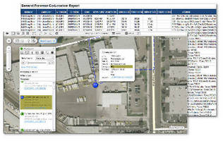
Aliso Viejo, CA, -Telogis, Inc., the platform for location intelligence, introduces the newest feature for its Telogis Fleet vehicle management application: the Field Management Co-Location Report. This new report breaks down the daily routine of field supervisors, including time spent at a jobsite, time spent driving, vehicle miles and time spent at other locations.
"Jobsite productivity and safety improve exponentially when a foreman or supervisor is on site," says Jason Koch, president, Telogis Fleet. "This feature is designed to encourage more time spent on site, raise the accountability of field management, and improve productivity and safety. It was designed specifically for our utility enterprise customers but is useful in any industry where one foreman or supervisor oversees numerous mobile resources."
The Field Management Co-Location Report uses GPS to determine when a foreman/supervisor's truck is located on a jobsite or other location related to the job, such as a maintenance shop or depot. The report compares when a vehicle is specifically "co-located" at a jobsite with other field resources to determine how much time is spent on site. A concise, easy-to-read report is compiled over customizable time periods that shows each supervisor's daily routine, allowing management to make decisions about how field resources are deployed and supervised.
Telogis Fleet is a real-time GPS fleet management solution that drives rapid return on investment for businesses of all sizes through improvement of productivity and operations. The application provides fleet managers and field resources with a comprehensive, scalable solution for fleet management, tracking and reporting. Industries served include utilities, telecommunications, OEM, construction, delivery, fleet leasing, food/beverage, pest control and waste management.
IRVINE, Calif., April 2, 2008 -- Telogis today announced the release of OnTrack 6, the most reliable and easy-to-use Software as a Service (SaaS) GPS Tracking Application on the market. Telogis' real-time GPS Fleet Tracking solution drives rapid return on investment for businesses of all sizes through improvement of productivity and enhancement of their operations. New features in this release include a Web 2.0 aesthetic makeover, advanced PDF and Excel reporting, updated GeoStream maps, and the integration of Live Messaging.
Telogis continuously improves OnTrack by delivering annual major releases to its customer base. "Software as a Service is ideally suited to the GPS Tracking marketplace, as it gives users improved functionality automatically. This release is further testament of our ability to innovate faster than our competition and deliver the industry's most robust solution," said Derek Jett, VP of Sales for Telogis.
"This major release, our sixth generation of OnTrack, builds upon our experience and the vast feedback we receive from our rapidly growing customer base."
Highlights of the OnTrack 6 release include:
-- Web 2.0 Makeover - Creating a fluid, easy to use GUI is core to building user adoption. OnTrack delivers an interface that is so intuitive that very basic computer users can effectively use the system in minutes.
-- Advanced PDF and Excel reporting - The OnTrack suite of 50+ reports has increased and been refined to improve readability. The added insight provided by these reports allows users to rapidly assess the state of their fleet and act upon that information.
-- Updated GeoStream Maps - Telogis provides the most up-to-date and fastest map data in the industry through its world class technology platform. This performance allows our customers to rapidly drill down into any level of their fleet and respond to both their customers' and drivers' needs.
-- Live Messaging - Our customers requested more effective communication with their fleet. Telogis delivered on this through the addition of Live Messaging through OnTrack Workforce. OnTrack Workforce allows users to instantly stay in contact with the fleet, allows drivers to easily communicate with base and can lead to an overall reduction in cellular voice usage.
Telogis OnTrack is available in three different editions - Standard, Professional and Enterprise. Visit www.telogis.com/ot6 for more information about OnTrack or call 1-866-835-6447 to speak with an account manager.


(6 August 2008) Remote Dynamics, Inc., a leading provider of GPS vehicle tracking solutions for commercial fleets, heavy equipment, and construction assets, today announced REDI Anywhere, a satellite monitoring service using the Orbcomm data network.
REDIview is used by hundreds of service, construction and equipment rental companies for real-time fuel management, utilisation analysis, maintenance management, and security monitoring. Currently, a wide array of vehicles and construction equipment are being managed through REDIview.
Now, REDIview is offering a new hardware platform that operates in remote regions. This new platform integrates seamlessly with Remote Dynamics' REDIview software, allowing users of the system to manage all their service vehicles and construction assets from REDIview no matter where they are located or which communications platform is required.
Remote Dynamics is proud to be launching this satellite-based service with an array of industry leading customers including Lampson International of Kennewick, WA, and Bigge Crane and Rigging of San Leandro, CA. "After a comprehensive search of asset management providers, we have selected Remote Dynamics as our service provider," said Bill Lampson, President and CEO of Lampson International. "They have proven themselves to have a unique understanding of the technology and our industry and we look forward to working with them in monitoring our cranes and equipment around the world."
"We are excited to be adding our comprehensive Orbcomm satellite solution," said Gary Hallgren, CEO of Remote Dynamics. "The construction and oil and gas industries need one equipment management solution no matter where their assets are located. By combining satellite communications with our existing fixed and portable GSM platforms, we continue on our mission of being the most comprehensive asset management solution in the industry."
ORBCOMM Inc a global satellite data communications company focusing on two-way Machine-to-Machine (M2M) communications and leading provider of space-based Automatic Identification System (AIS) services, today announced that it has commissioned the South African Gateway Earth Station (GES) into operation.
“The GES in South Africa supports our customers’ growing business in Africa by providing a key piece of geographical coverage. International expansion is a key component of our growth strategy and this agreement enables our International Value Added Resellers (IVARs) and original equipment manufacturers (OEMs), many of which already have distribution in the southern portions of Africa, to provide ORBCOMM enabled services to new outlets” said Marc Eisenberg, ORBCOMM’s Chief Executive Officer. “It also creates an opportunity for new sales channels with local providers in the surrounding areas, many of which are under-served by terrestrial networks.”
Savoya uses a proprietary web-based application See Web application.
..... Click the link for more information. to manage the ordering, tracking and administrative functions for chauffeured ground transportation. Through its certified vendor network, Savoya utilizes 20,000 vehicles in over 100 countries.
"The strategic combination of the REDIview solution and Savoya's Global Chauffeured Services Operating System operating system (OS)
Software that controls the operation of a computer, directs the input and output of data, keeps track of files, and controls the processing of computer programs.
..... Click the link for more information. allows real time visibility into exact vehicle location and adds another layer of tracking and accountability of chauffeurs," said Alex Danza, chief operating officer Chief Operating Officer (COO)
The officer of a firm responsible for day-to-day management, usually the president or an executive vice-president.
..... Click the link for more information. at Savoya. "The new system will provide historical data on vehicle routes which will allow us to provide the most secure ground transportation solution possible to our clients." Danza added, "In addition to increased oversight and tracking, the new system will allow Savoya to offer wireless access to the Internet in each vehicle."
Along with GPS technology, Remote Dynamics' REDIview Fleet solution will provide Savoya with detailed analysis by collecting real-time vehicle information such as vehicle speed, direction, idle time The duration of time a device is in an idle state, which means that it is operational, but not being used.
..... Click the link for more information., fuel efficiency, and ignition on/off.
"By integrating REDIview into the Savoya global command center, they will be able to better ensure a consistent, real-time, quality of service experience for their clients' chauffeured ground transportation," said Scott Broudy, vice president of channels and partners at Remote Dynamics. "REDIview provides a comprehensive view into the location of each vehicle, and provides important vehicle and chauffeur behavior data that will enable Savoya to better understand both the quality and cost of service delivery."
Under the terms of the Agreement, Certified Savoya Operators will benefit from a pre-negotiated program between Savoya and Remote Dynamics aimed to accelerate the outfitting of their vehicles with REDIview Fleet.
"HBR adds a significant increase in distribution channels to the REDIpartner program through their nationwide affiliations within the technology reseller channel," said Scott Broudy, vice president of strategic partnerships and channel sales for Remote Dynamics. "With a proven and well-respected reputation for designing and implementing enterprise-wide, enabling technologies that maximize the efficiencies of mobile resources, HBR is an excellent complement to REDIview's solutions-based delivery model."
HBR Technologies provides nationwide business consulting and technology services in almost 400 locations nationwide, representing more than 6,000 system engineers, including:
--2,400 HP/Compaq Technicians
--1,200 Cisco Professionals
--1,100 Microsoft Engineers
--800 IBM (International Business Machines Corporation, Armonk, NY, www.ibm.com) The world's largest computer company. IBM's product lines include the S/390 mainframes (zSeries), AS/400 midrange business systems (iSeries), RS/6000 workstations and servers (pSeries), Intel-based servers (xSeries) Technicians
--700 Symantec Specialists
--400 Citrix Professionals
"We have been providing mobile workforce solutions for more than a decade. By joining with Remote Dynamics as a distributor, HBR can provide fleet managers the business information to increase efficiency, identify issues and manage their workforce," said Jeff Romick, vice president, HBR Technologies. "The easy-to-use REDIview solution allows reporting that mobile workforce managers cannot produce with current tools. The enterprise scale and reliability of the REDIview system and the ability to deliver two-way mobile data communications data communications, application of telecommunications technology to the problem of transmitting data, especially to, from, or between computers. In popular usage, it is said that data communications make it possible for one computer to "talk" with another. are both vital business requirements of our clients that Remote Dynamics helps us meet."
"Mobile technologies are the leading enablers of integrated enterprise business solutions today. Our new REDIpartner program allows established integrators to combine enterprise-scale telematics Originally coined to mean the convergence of telecommunications and information processing, the term later evolved to refer to automation in automobiles. GPS navigation, integrated hands-free cellphones, wireless communications and automatic driving assistance systems all come under the
..... Click the link for more information. technologies with related support products to enhance business process workflow, automation and optimization," said Joe Pollard, senior vice president of sales and marketing for Remote Dynamics. "By blending our expertise with HBR, we will offer large business enterprises new ways to leverage state-of-the-art technologies that integrate back-end operations with mobile workforce and management efforts."
About HBR Technologies:
HBR Technologies, established in 1984 and headquartered in the Dallas/Fort Worth Metroplex The Dallas–Fort Worth–Arlington metropolitan area, a title designated by the U.S. Census as of 2003, encompasses 12 counties within the U.S. state of Texas. The metropolitan area is further divided into two metropolitan divisions: Dallas–Plano–Irving , is one of the oldest technology consulting and reseller firms in the world. The company was founded on, and continues with, a commitment to provide outstanding personal service to clients. HBR has a proven track record of helping corporations, government agencies, and educational institutions nationally. Clients rely on HBR Technologies for designing, acquiring, implementing, and supporting their technology infrastructure. The products and services include business consulting, Mobile Computing Using a computing device while in transit. Mobile computing implies wireless transmission, but wireless transmission does not necessarily imply mobile computing. Fixed wireless applications use satellites, radio systems and lasers to transmit between permanent objects such as buildings Solutions, technology assessments, LAN/WAN/MAN, Security, Network Management, Disaster Recovery/ Avoidance Planning, Wireless, Outsourcing of Technicians, Systems Engineers, and Project Managers, Hardware and Software Acquisition, Storage, Network Monitoring The term network monitoring describes the use of a system that constantly monitors a computer network for slow or failing systems and that notifies the network administrator in case of outages via email, pager or other alarms. , Standard and Extended Warranty The examples and perspective in this article or section may not represent a worldwide view of the subject.
Please [ improve this article] or discuss the issue on the talk page. Repair Services, Maintenance Agreements and Out of Warranty Break Fix.
About REDIview:
REDIview is a unique, easy-to-use system that implements today's leading wireless and network technologies. The Remote Dynamics mobile data-logging unit (MDLU) transmits minute-by-minute vehicle information via the GPRS (General Packet Radio Service) The first high-speed digital data service provided by cellular carriers that used the GSM technology. GPRS added a packet-switched channel to GSM, which uses dedicated, circuit-switched channels for voice conversations. network to Remote Dynamics network operations center See NOC.
Network Operations Center - (NOC) A location from which the operation of a network or internet is monitored. Additionally, this center usually serves as a clearinghouse for connectivity problems and efforts to resolve those problems.
..... Click the link for more information. (NOC (Network Operations Center) A central or regional location for monitoring a large network. Also called a "network management center" (NMC), "service management center" (SMC) or "network control center" (NCC), a NOC may be used to manage a large enterprise network, ) where the information is managed, stored and made available over the Internet. Combined with GPS tracking See vehicle tracking. , REDIview gives operators real-time tracking of their mobile assets while managing exception-based reports that identify areas of cost and service performance concerns. Associated cost reductions deliver immediate return on investment (ROI (Return On Investment) The monetary benefits derived from having spent money on developing or revising a system. In the IT world, there are more ways to compute ROI than Carter has liver pills (and for those of you who never heard of that expression, it means a lot). ) that increases revenues and operating efficiency for customers. More information on REDIview is available online at www.remotedynamics.com/product.html.
Aug 06, 2008 -- Remote Dynamics, Inc. a leading provider of GPS vehicle tracking solutions for commercial fleets, heavy equipment, and construction assets, today announced REDI Anywhere, a satellite monitoring service using the ORBCOMM data network. REDIview is used by hundreds of service, construction and equipment rental companies for real-time fuel management, utilization analysis, maintenance management, and security monitoring. Currently, a wide array of vehicles and construction equipment are being managed through REDIview. Now, REDIview is offering a new hardware platform that operates in remote regions. This new platform integrates seamlessly with Remote Dynamics' REDIview software, allowing users of the system to manage all their service vehicles and construction assets from REDIview no matter where they are located or which communications platform is required. Remote Dynamics is proud to be launching this satellite-based service with an array of industry leading customers including Lampson International of Kennewick, WA, and Bigge Crane and Rigging of San Leandro, CA. "After a comprehensive search of asset management providers, we have selected Remote Dynamics as our service provider," said Bill Lampson, President and CEO of Lampson International. "They have proven themselves to have a unique understanding of the technology and our industry and we look forward to working with them in monitoring our cranes and equipment around the world."

(General Packet Radio Service) The first high-speed digital data service provided by cellular carriers that used the GSM technology. GPRS added a packet-switched channel to GSM, which uses dedicated, circuit-switched channels for voice conversations.
GPRS works on GPRS cellphones as well as laptops and portable devices that have GPRS modems. Users have typically experienced downstream data rates up to 80 Kbps. GPRS is not the same as GSM's short messaging service (GSM-SMS), which is limited to messages of 160 bytes in length. GPRS was superseded by EDGE, which changed the modulation method to increase speed. See cellular generations, cellular vs. Wi-Fi, EDGE and GSM.
On June 29, 2004, the Bankruptcy Court entered an order confirming the our Third Amended Joint Plan of Reorganization, as modified. The Bankruptcy Court set out enterprise value at $25.3 million for purposes of distributions of new common stock under the reorganization plan.
In June of 2001, we received a 99-year exclusive license right to market, sell and operate VMI technology in the United States, Canada and Mexico, commonly referred to as "VMI technology," from the owner of such technology, Minorplanet Systems PLC. On June 14, 2004, the Bankruptcy Court approved a Compromise and Settlement Agreement among us Minorplanet Limited and Minorplanet PLC regarding the license agreement for the VMI technology, which allowed us to use, market and sell the VMI technology until December 31, 2004. On January 6, 2005, we and PLC entered into an Addendum to Compromise and Settlement Agreement which granted us the right to continue to market and sell the VMI product line to our existing VMI customers. Although we had already ceased actively marketing and selling the VMI product, the addendum will allow us to fulfill VMI product orders from our existing VMI customers.
@Track Communications, Inc. a leading provider of wireless-based vehicle fleet management and intelligent mobile-asset-tracking solutions, today announced that its subsidiary,Minorplanet Systems USA Limited, has entered into an agreement with GE Capital Fleet Services to market and sell the company's (VMI)Vehicle Management Information solution to commercial customers leasing vehicles from GE Capital Fleet Services.
The VMI technology helps maximize the productivity and profit of companies operating service vehicle fleets. It provides comprehensive and detailed reporting regarding the location of vehicles, the routes they have taken, time spent at each location, the speed and distance traveled, and time worked by service technicians. In addition, the technology provides extensive exception-based reporting capabilities regarding excessive speed, excessive idle time The duration of time a device is in an idle state, which means that it is operational, but not being used.
Wireless Data Transmission . The REDIview product utilizes the general packet radio service (“GPRS”) bearer channel of the GSM network to provide Internet protocol based wireless data transmission. Currently, there are two major carriers providing GSM/GPRS coverage in the United States: T-Mobile and AT&T Wireless, both of which provide coverage in the major metropolitan areas in the United States. These carriers have announced joint arrangements to continue to expand GSM/GPRS coverage in the United States, including interoperability among the two carriers. We believe the coverage, bandwidth and price of the GSM/GPRS network make it best suited for the next generation technology. We also use the ORBCOMM Satellite network to provide services for customers that are in remote areas not covered by the GSM footprint.
| Volume | |
| Day Range: | |
| Bid Price | |
| Ask Price | |
| Last Trade Time: |


 AI
AI


