News
News  Market Data
  Discover
Support: 888-992-3836
Copyright © 2023 InvestorsHub Inc.


ERHClongtimer
![]()
Register for free to join our community of investors and share your ideas. You will also get access to streaming quotes, interactive charts, trades, portfolio, live options flow and more tools.
Register for free to join our community of investors and share your ideas. You will also get access to streaming quotes, interactive charts, trades, portfolio, live options flow and more tools.
Just caught up on posts from the last month or so. Lots of angst on the board right now (and understandably so).
The implosion of oil prices and resulting depression of exploration company share prices has taken its toll on ERHC, not to mention the likely effects of toxic convertible debt financing.
Still, there have been positive developments: Work in Kenya and Chad is progressing; Chrome (SEO) has finally stepped up to the plate; and Peter & Sylvan continue to purchase shares.
I view the Chrome financing of $250,000, instead of a larger amount, as a good thing. Makes sense to finance in tranches at this point rather than a big lump 1) because the share price is so depressed - better terms might be possible after some volumetrics are determined for Block 11A and the market improves; 2) they have to pay interest on the financing amount, so less is better; 3) helps to encourage economizing on the part of management. If SEO hopes to preserve his investment, this will be repeated.
I think ERHC needs to go into a semi-hibernation (all the while doing what they can with Kenya & Chad) until this oil market depression subsides. That might mean asking Chad for an extension. Or shedding an asset or two. I don't know how realistic it is to expect a farm-in right now, when so many companies are shedding assets, not buying them. They certainly are not going to get top dollar.
It should be clear to management by now that convertible debt financing is the road to oblivion, especially with the oil market in the state that it is in now. Every dollar counts, and they have to batten down the hatches if they are going to weather the storm.
Management has all the more incentive to do so as they continue to ante up their stakes in the company. - LT
Slide 11 also has a nice update on the LAPSSET pipeline.
Slide 11 also has a nice update on the LAPSSET pipeline.
Some info like this might help:
http://www.africaoilcorp.com/i/pdf/Corporate-Presentation-November-2014.pdf
Lots of detailed charts and information about Kenya, including the Tausi prospect in Block 13T (slide 16), closest yet to Block 11A, coming from the south. Slide 17 contains information about prospects due east of Blocks 11A and 11B, alongside Lake Turkana.
Great presentation! ERHC needs to provide information like this about Block 11A and Chad! - LT
This maps shows the proximity of Block 13T and other prospects and leads in the region to ERHC's Block 11A, as well as the LAPSSET pipeline:

http://assets.geoexpro.com/uploads/e5064378-666b-4fc8-a233-c2b43716ed74/Discoveries-Prospects-and-Leads.jpg
And here's a post that has information about the Turkwel Basin (along the western border of Block 13T and 10BA), which is close to Block 11A and the "apparent basin" entering it in the south: http://investorshub.advfn.com/boards/read_msg.aspx?message_id=102131459
Here's one specialist company's assessment of the Turkwel Basin (more detailed info in post above):
Scotforth's continuing exploration of EARS suggests that Turkwel in Kenya will be one of the next petroliferous basins. Basin-wide RSDD-H reconnaissance has identified Hydrocarbon Lead Indicators ("HLIs") there, analogous to those in the nearby Lokichar Basin.
Scotforth Turkwel Brief
1. Perhaps he is confident that ERHC does not need his help to get through current circumstances.
2. Whatever he paid for his shares, SEO is invested for the same reason you or I are... to make money off his investment.
3. Again, whatever happens to the company, he is the one that is affected the most.
I don't like financing with these piranhas any more than you do, but in terms of share percent, it is a small number.
I wonder how successful another ERHC rights offering to shareholders would be if the shares came with warrants convertible in a couple years' time? That would be better than the immediate-to-180-day conversion period they negotiated earlier this year, and shareholders are more likely to hold on to their converted shares.
In any case, we went through a downdraft last EOY, and the share price rebounded. But this year we have potential for some really good concrete news, based on studies already performed by ERHC. Just hold on.
SEO owns the vast majority of that. Do you think he will stand by and let ERHC go belly-up, with his 40% (or so) ownership?
One would think he would work out some sort of financing deal before he would stand by and totally lose his investment. He has the most to lose of any of us.
Southern Man, you need to re-read Peter's "value proposition" presentation.

The idea is to discover and book reserves, add value, and sell... before production... even before development.
So a pipeline being in place is not even relevant to ERHC; if an oil field is found, they will sell out to the highest bidder, either the company as a whole or the assets.
The fact that a pipeline will be built is relevant, because it makes any resources found that much more valuable, due to the eventual marketability made possible by the pipeline.
Besides, even if they found oil today, it would take 2-4 years, maybe more, to develop the oil field.
Jsc, actually, I am leaning the other way, that drilling may happen before 3D. That is what Tullow did.
See my post here.
In my way of thinking, what is the point of spending money on shooting 3D if there isn't a working kitchen below? Tullow drilled to confirm there was something down there worth their time and money. Evidently their gravity readings and 2D gave them enough clarity to spud without it.
On the other hand, Block 11A has a lot of thick volcanics, so CEPSA/ERHC may feel they need to shoot 3D first to get enough clarity for a target.
But based on the positive comments in ERHC's Block 11A 2D seismic completion press release, I am hoping they are feeling confident enough to drill. - LT
Very informative Tullow video on exploration:
Finding The Prize: A story of oil exploration and discovery (YouTube HD; change to 1080p for better viewing quality)
Layman's explanation of how oil is created and trapped (Bookmark at 2:06)
Finding The Prize (Same video, lower resolution, Tullow site)
Good amount of Kenya footage. Couldn't help but notice the uncanny resemblance of the drilling camp (20 seconds into video, and more at 18:10) to ERHC's seismic camp.
"The drill bit, will in the end, tell whether the dream of the geologist and the engineer can come to fruition."
Excellent video; would definitely recommend taking out the 20 minutes to watch this. - LT
Will CEPSA/ERHC follow the Tullow Ngamia exploration path in Block 11A?
From what I can find, it appears Tullow drilled Ngamia-1 before shooting any 3D. They are just now concluding a 3D shoot over the field now. (See also this release.)
One could argue that there isn't much point to shooting 3D until a working hydrocarbon kitchen has been established. A well could confirm or dismiss that possibility.
If a kitchen is confirmed, thereafter 3D could help home in on targets of high probability.
Perhaps we'll know sooner more than later what will happen next.
Any other factors that might influence one option over the other?
His comments about source rocks were highlighted in this post. Did you read this, and his conclusion mentioned at the very bottom of the post?
Of course, as with any exploration campaign, we really won't know the reality until a well is drilled.
OC/Seek, another good (easy) read is the slide presentation referenced here. Page 8 mentions sediments of 700 meters thick in the Lotikipi basin. However, ERHC states the following in their most recent press release regarding Block 11A:
The full tensor gravity gradiometry (FTG) survey conducted earlier on the Block identified two separate basins, Anam and Tarach, which cover 1,600 square kilometers to the west of Block 11A and 2,500 square kilometers to east, respectively. The basins are estimated to contain up to six to seven kilometers of sediments. Based on the analogy with the Lokichar basin, burial history is sufficient to generate commercial amounts of liquid hydrocarbons.
http://erhc.com/news/leads-in-kenya-block-11a/
In reply to seek (his questions in blue):
1) Do you know the date of the research paper done by petroleum geologist Bernard Kipsang Rop, Ph.D? Posted online August 4th, 2011, http://www.epgeology.com/articles/kenya-rift-basin.html
2) DR. THOU did a more comprehensive report on this region of Kenya a few years ago incorporating several different studies as I recall. Can you post a link to that study? I have searched but cannot find it. I believe Dr. Thou's report was more recent than Dr. Rop's. (Last name is Thuo, not Thou.) Submitted November 9th, 2010, http://investorshub.advfn.com/boards/read_msg.aspx?message_id=78684739
3) The most encouraging factor to me would be the vastness of the two basins should provide a large number of prospects in a "string of pearls" fashion along the rift boundaries or margins. Comment please? Based on the magnetic data, I would expect that multiple prospects, if they exist, to be clustered in the two basin areas, Anam and Tarach. There is the question of the apparent basin that enters into the southern portion of Block 11A. Evidently no seismic has been shot down there yet.
Yep, not exactly a blob when you put it in those terms. Hopefully we'll get to see a leads and prospects map at some point to give us a better understanding of the block.
This geological map from BEICIP-Kenya Ministry of Energy shows quite a bit faulting in the Tarach basin area (orange area surrounded by purple), which could provide migration routes if they are deep enough.

kownski, that's exactly what I thought, but I have restrained myself from mentioning it!
OC, I think the press release was referring to the areal extent of the traps (top image below):

Closure. In map view (top), closure is the area within the deepest structural contour that forms a trapping geometry, in this case 1300 ft [390 m].
________________________________________________________________________________________________________________________
Closure
2. n. [Geology]
The area, or areal closure, included in the lowest closing contour of a trap. Measurements of both the areal closure and the distance from the apex to the lowest closing contour are typically incorporated in calculations of the estimated hydrocarbon content of a trap.
SOURCE: http://www.glossary.oilfield.slb.com/en/Terms.aspx?LookIn=term%20name&filter=closure
So, yes, this translates to what could look like a blob.
Basically then, the press release is indicating that if the traps contain oil, there is going to be a lot of it, because they enclose large areas (horizontal extent), provided the oil-bearing layers are also thick (vertical extent)!
There is another definition of closure, which refers to the vertical extent (bottom image above, see link).
The blobs... they're back! Anam and Tarach basin locations, areas mentioned in today's press release:

The full tensor gravity gradiometry (FTG) survey conducted earlier on the Block identified two separate basins, Anam and Tarach, which cover 1,600 square kilometers to the west of Block 11A and 2,500 square kilometers to east, respectively.
http://erhc.com/news/leads-in-kenya-block-11a/
BT, that would be my guess. Maybe a Brit can enlighten us.
Untrammelled - Not deprived of freedom of action or expression; not restricted or hampered.
Maybe "The basins are estimated to contain up to six to seven kilometers of sediments" will provide sufficient reservoir thickness.
That is a huge amount of sediment!
ONGC on the prowl for Tullow; aiming to triple its African production over the next 16 years.
THE WALLSTREET JOURNAL
India’s ONGC Videsh in Deal Talks With U.K.’s Tullow
ONGC’s Director of Exploration Says Tullow is Willing to Sell Assets
By JUSTIN SCHECK and ALEXIS FLYNN
Updated Nov. 4, 2014 2:24 p.m. ET
CAPE TOWN—India’s state-owned oil producer ONGC Videsh has been in deal talks in recent weeks with the U.K.’s Tullow Oil PLC, ONGC’s exploration chief said Tuesday.
Anil Bhandari, ONGC’s director of exploration, said his staff met Tullow executives in London last week, and they will continue their talks in coming days. Mr. Bhandari said Tullow executives told him that “currently, they are not interested” in selling the company, but they are willing to sell assets. Mr. Bhandari said his company is interested in buying shares of Tullow properties in Ghana and elsewhere in Africa.
ONGC has assets across Africa, in countries including Libya, Sudan and Mozambique. Mr. Bhandari said he’s interested in developing both onshore and deepwater fields in Africa. In a speech Tuesday at a Cape Town conference he said that his company is aiming to triple its African production over the next 16 years.
Though once well-known for its knack of finding oil---Tullow was regularly voted “Most Admired Explorer” in a survey run by research firm Wood Mackenzie---the company’s fortunes have declined recently, leaving some executives fearing a takeover, people familiar with the matter said.
Tullow’s share price has fallen 46% this year and by more than two-thirds since early 2012, in part thanks to falling oil prices but also due to the company’s lack of exploration success in recent times. Tullow’s market value Friday was around GBP4.4 billion ($7.0 billion).
Since making huge discoveries in Ghana and Uganda in the decade after 2000, Tullow has struggled to repeat the trick. Its shares dropped sharply last month after the company announced mixed drilling results in Kenya.
Also last month, ratings agency Moody’s downgraded the company’s debt to Ba3, citing its overreliance on Ghana, where its Jubilee field accounts for nearly half the company’s oil production.
http://online.wsj.com/articles/indias-ongc-videsh-has-been-in-deal-talks-with-uks-tullow-1415119910
The pipeline running by ERHC's BDS 2008 Focus Areas is going to happen. Route planning and engineering work already underway. Glencore has deep pockets, so no worries about funding:

See pages 11-15 of this PDF.
Having a pipeline nearby will make any resources ERHC finds that much more valuable.
Or perhaps Glencore:
Alex Beard, Head of Oil of Glencore, said, "Today's completion of our acquisition of Caracal marks a natural progression in the development of Glencore Oil's exploration and production portfolio. Caracal's expertise and knowledge of operating in Chad will strengthen our growing African oil business. The Chad asset brings with it a very exciting programme of development and exploration and we look forward to the next step of unlocking the potential of the Doba and Doseo basins."
http://www.londonstockexchange.com/exchange/news/market-news/market-news-detail/12010282.html
Glencore E&P (Canada) Inc. is a wholly owned subsidiary of Glencore International PLC involved in the exploration, development and production of oil in the Republic of Chad in Africa. Through wholly-owned subsidiaries, the Company is a party to three production sharing contracts with the Government of Chad which provide the Company with the exclusive rights to develop: (i) the Chari-Ouest (Borogop) and Chari-Doseo blocks in Southern Chad in the Doseo and Eastern Doba basin; (ii) the DOB (Mangara) and DOI (Badila) blocks; and (iii) the DOH (N'Donambo) block.
Recent Updates
Glencore E&P (Canada) Inc. is hiring: Senior Exploitation Engineer
https://www.linkedin.com/company/griffiths-energy-international-inc-
I view Chad as a lifesaver for ERHC. It is the only holding ERHC has currently that has proven oil 15-20 km (9-13 miles) away, and for which they already have some seismic.
So the probability that they strike oil is high, especially since the initial "air gravity and magnetic anomaly maps strongly confirm the viability of the leads". Then they will have resources (value) on the books.
The most recent estimate for both focus areas that I can find is listed on this slide from ERHC's SeeThruEquity Microcap Investor Conference presentation in November, 2013:

More recently, in their "Presidential Seal of Approval on BDS 2008" press release of April 28, 2014, ERHC again estimated "the un-risked resource potential in the two focus areas in BDS 2008 to be 250 million barrels of oil equivalent (MMBOE)."
Likely, when the analysis of the airborne gravity/magnetic survey done by Bridgeporth is complete, we will get updated information. We are already off to a good start.
I don't know if 250 MMBoe unrisked is enough to attract CEPSA's interest; but hopefully it will be enough to entice a mid-sized company to farm in.
And of course, if the 2-D seismic is compelling enough, ERHC still has the option of farming out another piece of the pie in Block 11A.
And then there is the EEZ.
Just a reminder of the numbers involved with ERHC's BDS 2008 Block in Chad:

100 MMBoe unrisked estimate. And this is just with Focus Area 1.
Focus Area 2 was confirmed also.
From the news release:
» "preliminary findings ... strongly confirm the viability of leads in two focus areas"
» "the first-order leveled raw free-air gravity and magnetic anomaly maps strongly confirm the viability of the leads"
» "The findings are very impressive"
For more about Focus Area 2, see this post.
OCB, that caught my eye, as well as this:
[T]he first-order leveled raw free-air gravity and magnetic anomaly maps strongly confirm the viability of the leads," said ERHC's Senior Geoscientist Michael Shafie. "The findings are very impressive."
King, thanks for the links. Yes, I can see the full profile via the links you provided.
I did not see any of the "two camps" discussion due to the noise filter I have in place. There was a point when the supposed "short ratio" and other side issues were being discussed ad infinitum on the board, and so I disconnected, making use of the ignore feature.
Thanks again. - LT
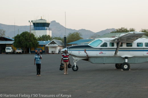
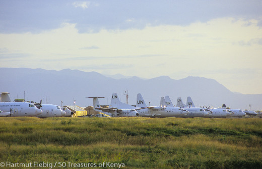
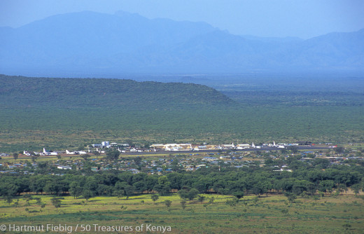
When a company throws this many resources at a license area, they (CEPSA) have to be pretty serious about its prospects:

Larger version (originally posted by Dr. J): http://erhc.com/photos/309/original/
I don't know anything about these things, but this camp seems a little much just to shoot some 2D. Looks like they plan to stay for a while. Sure seems telling about what CEPSA thinks lies below. - LT
King, here are a couple more from LinkedIn:
LinkedIn Member
Oil and Gas CSR, Security, Environmental, Community Relations Kenya NE and NW Province. Aviation GM. Diplomacy & Defence
KenyaOil & Energy
Current
Consultant Operational Liaison Coordinator at CEPSA
• Supervision and coordination of the Social... camps in Block 11A Lokichoggio NW Kenya....
Zachary M.
Environmental Scientist | Writer | Deputy Director Green Generation Association
KenyaOil & Energy
Past
Environmental Specialist at CEPSA
Environmental monitoring during the activities of a 2D seismic survey(Block 11A). Developed an...
Current
Deputy Director at Green Generation Association Kenya
I don't have LinkedIn premium, so I can't see their full profiles. Would love to see the rest of that bullet point in the first profile.
Lokichoggio is another name for Lokichokio, which I mentioned in this post as being near the possible location of the camp pictured in ERHC's photos. -LT
Quite the compound. Based on the camera angle and topography in the distance, it looks like the base camp could have been situated about here:
BGP 2D Seismic Camp?
This may indicate that CEPSA/ERHC are focusing their attention on the northern part of Block 11A.
If you zoom-in the linked map and look due west from the conjectured camp location and above the topmost "A1" highway marker, you will see the town of Lokichokio. There, they have a fairly modern airport with a tarmac runway. So even though this is a remote part of Kenya, it has decent infrastructure, which will serve well if oil is found.
You can read more about Lokichokio here, about two-thirds down the page. Some information about the Lotikipi Plains below that also.
Another Turkana water basin video:
Groundwater reserves in Northern Kenya
Vast Water Reserves Found in Drought-Prone Northern Kenya
Ancient water = ancient lush plant life = present-day oil.
If the Lotikipi Plain has as much oil as it does water, we will all be dancing as well:
Large Water Reservior Discovered in Turkana
Huge underground water reserve discovered in drought-stricken Kenya
Old news, but interesting to see a video about it. Good news for the folks living in that area.
Gremlin, thanks for posting. The mere fact that CEPSA has committed to phase 2 shows they like what they see. We already know they aren't hesitant about walking if they don't (per the incident in Block 12B).
Dan's elaborative comments make it apparent that there are areas of high interest in Block 11A, apparently enough that drilling will happen sooner or later. At this point, the two options are, 1) drill, or 2) shoot 3D (and what would be the point of that if you did not intend to drill?).
So yes, the second phase of exploration is underway. The contracting parties are in the process of identifying the most highly prospective areas through processing, interpreting and analyzing the data that has been gathered to date. They will then determine whether additional 3D seismic is needed or if they have a high enough level of confidence with the existing data to move directly to drilling.
What's happening on the macro scale in the oil sector should be considered also... Oil has dropped about 18% from where it was a year ago, all since June, with no immediate likelihood it will reverse direction. Petroleum stocks have fallen across the board.
http://www.infomine.com/investment/metal-prices/crude-oil/1-year/
http://finance.yahoo.com/blogs/talking-numbers/here-s-a--sinister--looking-oil-chart-210216840.html
Of course, it would help if ERHC would release some eye candy from their 2D seismic done on Block 11A in Kenya. - LT
Once they get the approval of the next step of their plan, they will PR it. This is the real info that investors want to know and we ALL want to know now. But they can't/won't tell us now until they get approval. This does not change the 2 year time table.
Doc, reading between the lines with your e-mail exchanges with Dan, it sounds to me that ERHC/CEPSA have submitted plans for the next phase.
If CEPSA pulled out, Kenya would not have to approve it. They would simply make an announcement like they did with Swala/Tullow and be done with it.
So I think the next thing we hear out of Block 11A are plans for the second exploration period.
From research I've done in the past, the first exploration period could end as late as September 26th. So I don't know why there has been hand-wringing about there being no announcement in the first place.
The blue text in this link highlights the dates involved: http://investorshub.advfn.com/boards/read_msg.aspx?message_id=95619504
Maybe CEPSA liked what they saw in Block 11A so much (with the results of the 2D seismic completed up to that point), that in comparison, they did not like what they saw in Block 12B, at least not enough to go forward without shooting 3D. And so they decided they could afford not to gamble in Block 12B, seeing what they have in Block 11A.
Just some conjecture.
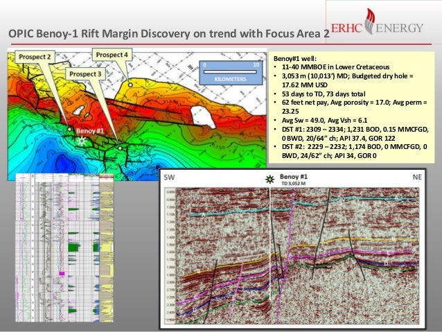
ERHC's Focus Area 2 proximity to Benoy-1 discovery
The maps below confirm King's assessment of the distance from Benoy-1 to the edge of ERHC's BDS-2008 Block.
This map shows where ERHC's Focus Area 2 is in relation to Benoy-1:
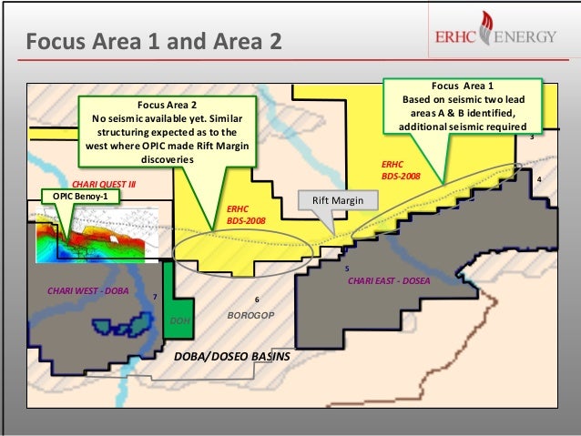
I have edited the map below, adding the scale twice to measure the distance from Benoy-1 to BDS-2008. It appears to be almost exactly 70 km (43 miles) between them, and probably about 125 km (78 miles) to the center of Focus Area 2:

(Original image here.)
This map has the advantage of showing the gravity readings, which provides for a better prospectivity assessment than with just going by proximity alone. I am still trying to figure out how to make sense of these things, but in comparison to Benoy-1, the arrows I have added in the map blowup below show areas that look similar:

This section definitely looks like a margin area, which jibes with the bold brown line showing the edge of the Doba Basin. Notice that this map shows much less of the basin located in BDS-2008 than does ERHC's map.
Based on this, I would expect ERHC to focus on the southern edge of BDS-2008. However, the gravity data shown in the map above is probably low resolution, and Bridgeporth's airborne gravity/magnetic survey will no doubt provide much greater resolution of the entire focus area, giving ERHC a better indication of prospective areas. - LT
P.S.: The ERHC slide below illustrates the greater detail that higher-resolution data can provide (compare map below with the one above in regard to Benoy-1).