 News
News  Market Data
  Discover
Support: 888-992-3836
Copyright © 2023 InvestorsHub Inc.


F6
![]()
Register for free to join our community of investors and share your ideas. You will also get access to streaming quotes, interactive charts, trades, portfolio, live options flow and more tools.
Register for free to join our community of investors and share your ideas. You will also get access to streaming quotes, interactive charts, trades, portfolio, live options flow and more tools.
Vortex Data Message
http://www.nhc.noaa.gov/text/MIAREPNT2.shtml [via http://www.nhc.noaa.gov/recon.php ]000
URNT12 KNHC 251133
VORTEX DATA MESSAGE AL092017
A. 25/11:22:30Z
B. 26 deg 18 min N
095 deg 48 min W
C. 700 mb 2657 m
D. 74 kt
E. 194 deg 7 nm
F. 284 deg 80 kt
G. 198 deg 8 nm
H. 951 mb
I. 14 C / 3046 m
J. 18 C / 3052 m
K. 12 C / NA
L. OPEN SE
M. C12
N. 12345 / 07
O. 0.02 / 1.25 nm
P. AF305 1709A HARVEY OB 17
MAX OUTBOUND AND MAX FL WIND 96 KT 042 / 10 NM 11:25:30Z
CNTR DROPSONDE SFC WIND 230 / 8 KT
;
HARVEY 5 AM CDT POSITION ESTIMATE...
5:00 AM CDT Fri Aug 25
Location: 26.1°N 95.5°W
Moving: NW at 10 mph
Min pressure: 958 mb
Max sustained: 105 mph
http://www.nhc.noaa.gov/
*
HURRICANE HARVEY DANGEROUSLY APPROACHING THE TEXAS COAST...
Location: 25.9°N 95.4°W
Moving: NW at 9 mph
Min pressure: 967 mb
Max sustained: 105 mph
http://www.nhc.noaa.gov/
Hurricane Harvey Forecast Discussion
http://www.nhc.noaa.gov/text/refresh/MIATCDAT4+shtml/250847.shtml000
WTNT44 KNHC 250847
TCDAT4
Hurricane Harvey Discussion Number 20
NWS National Hurricane Center Miami FL AL092017
400 AM CDT Fri Aug 25 2017
The satellite presentation has improved during the past several
hours with an intermittent eye feature surrounded by a ring of very
deep convection. There are various cyclonically curved convective
bands primarily to the north of the eye and the outflow is fair.
NOAA and Air Force Hurricane Hunter planes penetrated the eye
various times during the past several hours, and the most
significant data were a flight-level peak wind of 103 knots, and a
peak SFMR surface wind of 88 kt. The central pressure dropped
to 967 mb. Based on these data, the initial intensity was adjusted
upward to 90 kt. Another reconnaissance plane will be in the eye of
Harvey shortly.
Since Harvey is embedded within light shear and moving over warm
waters, additional strengthening is anticipated before landfall in
about 24 hours. Thereafter, gradual weakening is forecast but since
a good portion of the circulation will remain over water, the
weakening process could be slower than normal.
Radar and reconnaissance fixes indicate that Harvey is moving toward
the northwest or 320 degrees at 8 kt. The hurricane is on the
western edge of a persistent area of high pressure over the eastern
Gulf of Mexico, and this pattern will maintain the current hurricane
motion until landfall. Once Harvey is inland over Texas, the
steering currents are forecast to collapse and the cyclone should
begin to meander, prolonging the flooding conditions for several
days. The track guidance between now and landfall is very consistent
and there is high confidence in the track forecast. After landfall,
the track models show large variability and the confidence is low.
In any case, NHC forecast depicts a slow moving tropical cyclone
near or over Texas for the next five days.
Once again, it is very critical that users not focus on the exact
forecast track of Harvey, since cycle-to-cycle adjustments are
likely. All locations within the hurricane and storm surge warning
areas should be preparing for the possibility of major
hurricane-force winds and life-threatening storm surge.
Key Messages:
1. Harvey is expected to be a major hurricane at landfall, bringing
life-threatening storm surge, rainfall, and wind hazards to portions
of the Texas coast. Preparations to protect life and property should
be completed this morning, as tropical-storm-force winds will first
arrive in the hurricane and storm surge warning areas later today.
2. A Storm Surge Warning is in effect for much of the Texas coast.
Life-threatening storm surge flooding could reach heights of 6 to 12
feet above ground level at the coast between the north entrance of
the Padre Island National Seashore and Sargent. For a depiction of
areas at risk, see the Storm Surge Watch/Warning Graphic at
hurricanes.gov.
3. Devastating and life-threatening flooding is expected across the
middle and upper Texas coast from heavy rainfall of 15 to 25 inches,
with isolated amounts as high as 35 inches, from today through next
Wednesday. Please refer to products from your local National Weather
Service office and the NOAA Weather Prediction Center for more
information on the flooding hazard.
4. The Potential Storm Surge Flooding Map is available on the NHC
website. This product depicts a reasonable worst-case scenario -
the amount of inundation that has a 10 percent chance of being
exceeded at each individual location. This map best represents
the flooding potential in those locations within the watch and
warning areas.
FORECAST POSITIONS AND MAX WINDS
INIT 25/0900Z 25.9N 95.4W 90 KT 105 MPH
12H 25/1800Z 26.9N 96.3W 105 KT 120 MPH
24H 26/0600Z 28.0N 97.1W 105 KT 120 MPH
36H 26/1800Z 28.5N 97.4W 65 KT 75 MPH...INLAND
48H 27/0600Z 28.5N 97.5W 60 KT 70 MPH...INLAND
72H 28/0600Z 28.3N 97.0W 35 KT 40 MPH...INLAND
96H 29/0600Z 28.5N 96.0W 35 KT 40 MPH...OVER WATER
120H 30/0600Z 29.5N 95.0W 35 KT 40 MPH...INLAND
$$
Forecaster Avila
DANGEROUS HURRICANE HARVEY STRENGTHENING... ...WINDS REACH 105 MPH...
1:00 AM CDT Fri Aug 25
Location: 25.6°N 95.1°W
Moving: NW at 10 mph
Min pressure: 967 mb
Max sustained: 105 mph
http://www.nhc.noaa.gov/
Hurricane Harvey Public Advisory
http://www.nhc.noaa.gov/text/refresh/MIATCPAT4+shtml/250552.shtml000
WTNT34 KNHC 250552
TCPAT4
BULLETIN
Hurricane Harvey Intermediate Advisory Number 19A
NWS National Hurricane Center Miami FL AL092017
100 AM CDT Fri Aug 25 2017
...DANGEROUS HURRICANE HARVEY STRENGTHENING...
...WINDS REACH 105 MPH...
SUMMARY OF 100 AM CDT...0600 UTC...INFORMATION
-----------------------------------------------
LOCATION...25.6N 95.1W
ABOUT 210 MI...335 KM SE OF CORPUS CHRISTI TEXAS
ABOUT 210 MI...335 KM SSE OF PORT OCONNOR TEXAS
MAXIMUM SUSTAINED WINDS...105 MPH...165 KM/H
PRESENT MOVEMENT...NW OR 315 DEGREES AT 10 MPH...17 KM/H
MINIMUM CENTRAL PRESSURE...967 MB...28.56 INCHES
WATCHES AND WARNINGS
--------------------
CHANGES WITH THIS ADVISORY:
None.
SUMMARY OF WATCHES AND WARNINGS IN EFFECT:
A Storm Surge Warning is in effect for...
* Port Mansfield to High Island Texas
A Storm Surge Watch is in effect for...
* South of Port Mansfield Texas to the Mouth of the Rio Grande
A Hurricane Warning is in effect for...
* Port Mansfield to Sargent Texas
A Tropical Storm Warning is in effect for...
* North of Sargent to High Island Texas
* South of Port Mansfield Texas to the Mouth of the Rio Grande
A Hurricane Watch is in effect for...
* South of Port Mansfield Texas to the Mouth of the Rio Grande
A Tropical Storm Watch is in effect for...
* South of the Mouth of the Rio Grande to Boca de Catan Mexico
A Storm Surge Warning means there is a danger of life-threatening
inundation, from rising water moving inland from the coastline,
during the next 36 hours in the indicated locations. For a depiction
of areas at risk, please see the National Weather Service Storm
Surge Watch/Warning Graphic, available at hurricanes.gov. This is a
life-threatening situation. Persons located within these areas
should take all necessary actions to protect life and property from
rising water and the potential for other dangerous conditions.
Promptly follow evacuation and other instructions from local
officials.
A Hurricane Warning means that hurricane conditions are expected
somewhere within the warning area. A warning is typically issued
36 hours before the anticipated first occurrence of tropical-storm-
force winds, conditions that make outside preparations difficult or
dangerous. Preparations to protect life and property should be
rushed to completion.
A Storm Surge Watch means there is a possibility of life-
threatening inundation, from rising water moving inland from the
coastline, in the indicated locations during the next 48 hours.
A Hurricane Watch means that hurricane conditions are possible
within the watch area.
In addition, interests in southwestern Louisiana should continue to
monitor the progress of this system.
For storm information specific to your area in the United
States, including possible inland watches and warnings, please
monitor products issued by your local National Weather Service
forecast office. For storm information specific to your area outside
the United States, please monitor products issued by your national
meteorological service.
DISCUSSION AND 48-HOUR OUTLOOK
------------------------------
At 100 AM CDT (0600 UTC), the eye of Hurricane Harvey was located
near latitude 25.6 North, longitude 95.1 West. Harvey is moving
toward the northwest near 10 mph (17 km/h), and this general
motion is expected to continue with a decrease in forward speed
during the next couple of days. On the forecast track, Harvey will
approach the middle Texas coast later today and make landfall Friday
night or early Saturday. Harvey is then likely to stall near or
just inland of the middle Texas coast through the weekend.
Reports from Air Force and NOAA Hurricane Hunter planes indicate
that the maximum sustained winds have increased to near 105 mph (165
km/h) with higher gusts. Some additional strengthening is possible,
and Harvey is expected to become a major hurricane before it reaches
the middle Texas coast.
Hurricane-force winds extend outward up to 25 miles (35 km) from
the center and tropical-storm-force winds extend outward up to 105
miles (165 km).
The latest minimum central pressure recently reported by both
reconnaissance planes was 967 mb (28.56 inches).
HAZARDS AFFECTING LAND
----------------------
RAINFALL: Harvey is expected to produce total rain accumulations
of 15 to 25 inches and isolated maximum amounts of 35 inches over
the middle and upper Texas coast through next Wednesday. During
the same time period Harvey is expected to produce total rain
accumulations of 7 to 15 inches in far south Texas and the Texas
Hill Country eastward through central and southwest Louisiana, with
accumulations of up to 7 inches extending into other parts of Texas
and the lower Mississippi Valley. Rainfall from Harvey will cause
devastating and life-threatening flooding.
STORM SURGE: The combination of a dangerous storm surge and the
tide will cause normally dry areas near the coast to be flooded by
rising waters moving inland from the shoreline. The water is
expected to reach the following heights above ground if the peak
surge occurs at the time of high tide...
N Entrance Padre Island Natl Seashore to Sargent...6 to 12 ft
Sargent to Jamaica Beach...5 to 8 ft
Port Mansfield to N Entrance Padre Island Natl Seashore...5 to 7 ft
Jamaica Beach to High Island...2 to 4 ft
Mouth of the Rio Grande to Port Mansfield...2 to 4 ft
High Island to Morgan City...1 to 3 ft
The deepest water will occur along the immediate coast near and to
the northeast of the landfall location, where the surge will be
accompanied by large and destructive waves. Surge-related flooding
depends on the relative timing of the surge and the tidal cycle, and
can vary greatly over short distances. For information specific to
your area, please see products issued by your local National Weather
Service forecast office.
WIND: Hurricane conditions are likely within the hurricane warning
area late Friday and Friday night, with tropical storm conditions
expected to first reach the coast in the hurricane warning area
later this morning. These conditions are likely to persist
into Saturday in portions of the hurricane and tropical storm
warning area.
SURF: Swells generated by Harvey will begin to affect the
Texas, Louisiana, and northeast Mexico coasts later this morning.
These swells are likely to cause life-threatening surf and rip
current conditions. Please consult products from your local weather
office.
TORNADOES: Isolated tornadoes are possible across portions of the
middle and upper Texas coast on Friday.
NEXT ADVISORY
-------------
Next complete advisory at 400 AM CDT.
$$
Forecaster Avila
Hurricane Harvey - Radar Coverages - Images and Loops
via e.g. https://radar.weather.gov/ :
South Plains Sector
https://radar.weather.gov/ridge/Conus/southplains.php

https://radar.weather.gov/ridge/Conus/southplains.php / https://radar.weather.gov/ridge/Conus/southplains_lite.php [will update/remain current; refresh this post to see latest]

https://radar.weather.gov/ridge/Conus/southplains_loop.php / https://radar.weather.gov/ridge/Conus/southplains_lite_loop.php [will update/remain current; refresh this post to see latest]
Southern Mississippi Valley Sector
https://radar.weather.gov/ridge/Conus/southmissvly.php

https://radar.weather.gov/ridge/Conus/southmissvly.php / https://radar.weather.gov/ridge/Conus/southmissvly_lite.php [will update/remain current; refresh this post to see latest]

https://radar.weather.gov/ridge/Conus/southmissvly_loop.php / https://radar.weather.gov/ridge/Conus/southmissvly_lite_loop.php [will update/remain current; refresh this post to see latest]
Brownsville, TX Radar
https://radar.weather.gov/ridge/radar.php?rid=bro
Short Range Images
Base Reflectivity

https://radar.weather.gov/ridge/radar.php?rid=bro&product=N0R&overlay=11101111&loop=no / https://radar.weather.gov/ridge/radar_lite.php?product=N0R&rid=BRO&loop=no [will update/remain current; refresh this post to see latest]

https://radar.weather.gov/ridge/radar.php?rid=bro&overlays=11101111&product=N0R&loop=yes / https://radar.weather.gov/ridge/radar_lite.php?rid=bro&product=N0R&loop=yes [will update/remain current; refresh this post to see latest]
Base Velocity

https://radar.weather.gov/ridge/radar.php?rid=bro&overlays=11101111&product=N0V&loop=no / https://radar.weather.gov/ridge/radar_lite.php?rid=bro&product=N0V&loop=no [will update/remain current; refresh this post to see latest]

https://radar.weather.gov/ridge/radar.php?rid=BRO&product=N0V&overlay=11101111&loop=yes / https://radar.weather.gov/ridge/radar_lite.php?product=N0V&rid=BRO&loop=yes [will update/remain current; refresh this post to see latest]
Storm Total Precipitation

https://radar.weather.gov/ridge/radar.php?rid=bro&overlays=11101111&product=NTP&loop=no / https://radar.weather.gov/ridge/radar_lite.php?rid=bro&product=NTP&loop=no [will update/remain current; refresh this post to see latest]

https://radar.weather.gov/ridge/radar.php?rid=BRO&product=NTP&overlay=11101111&loop=yes / https://radar.weather.gov/ridge/radar_lite.php?product=NTP&rid=BRO&loop=yes [will update/remain current; refresh this post to see latest]
Long Range Images
Base Reflectivity

https://radar.weather.gov/ridge/radar.php?rid=bro&overlays=11101111&product=N0Z&loop=no / https://radar.weather.gov/ridge/radar_lite.php?rid=bro&product=N0Z&loop=no [will update/remain current; refresh this post to see latest]

https://radar.weather.gov/ridge/radar.php?rid=BRO&product=N0Z&overlay=11101111&loop=yes / https://radar.weather.gov/ridge/radar_lite.php?product=N0Z&rid=BRO&loop=yes [will update/remain current; refresh this post to see latest]
Corpus Christi, TX Radar
https://radar.weather.gov/ridge/radar.php?rid=crp
Short Range Images
Base Reflectivity

https://radar.weather.gov/ridge/radar.php?rid=crp&product=N0R&overlay=11101111&loop=no / https://radar.weather.gov/ridge/radar_lite.php?product=N0R&rid=CRP&loop=no [will update/remain current; refresh this post to see latest]

https://radar.weather.gov/ridge/radar.php?rid=crp&overlays=11101111&product=N0R&loop=yes / https://radar.weather.gov/ridge/radar_lite.php?rid=crp&product=N0R&loop=yes [will update/remain current; refresh this post to see latest]
Base Velocity

https://radar.weather.gov/ridge/radar.php?rid=crp&product=N0V&overlay=11101111&loop=no / https://radar.weather.gov/ridge/radar_lite.php?product=N0V&rid=CRP&loop=no [will update/remain current; refresh this post to see latest]

https://radar.weather.gov/ridge/radar.php?rid=crp&overlays=11101111&product=N0V&loop=yes / https://radar.weather.gov/ridge/radar_lite.php?rid=crp&product=N0V&loop=yes [will update/remain current; refresh this post to see latest]
Storm Total Precipitation

https://radar.weather.gov/ridge/radar.php?rid=crp&product=NTP&overlay=11101111&loop=no / https://radar.weather.gov/ridge/radar_lite.php?product=NTP&rid=CRP&loop=no [will update/remain current; refresh this post to see latest]

https://radar.weather.gov/ridge/radar.php?rid=crp&overlays=11101111&product=NTP&loop=yes / https://radar.weather.gov/ridge/radar_lite.php?rid=crp&product=NTP&loop=yes [will update/remain current; refresh this post to see latest]
Long Range Images
Base Reflectivity

https://radar.weather.gov/ridge/radar.php?product=N0Z&rid=CRP&loop=no / https://radar.weather.gov/ridge/radar_lite.php?product=N0Z&rid=CRP&loop=no [will update/remain current; refresh this post to see latest]

https://radar.weather.gov/ridge/radar.php?rid=crp&overlays=11101111&product=N0Z&loop=yes / https://radar.weather.gov/ridge/radar_lite.php?rid=crp&product=N0Z&loop=yes [will update/remain current; refresh this post to see latest]
Austin/San Antonio, TX Radar
https://radar.weather.gov/ridge/radar.php?rid=ewx
Short Range Images
Base Reflectivity

https://radar.weather.gov/ridge/radar.php?rid=ewx&product=N0R&overlay=11101111&loop=no / https://radar.weather.gov/ridge/radar_lite.php?product=N0R&rid=EWX&loop=no [will update/remain current; refresh this post to see latest]

https://radar.weather.gov/ridge/radar.php?rid=ewx&overlays=11101111&product=N0R&loop=yes / https://radar.weather.gov/ridge/radar_lite.php?rid=ewx&product=N0R&loop=yes [will update/remain current; refresh this post to see latest]
Base Velocity

https://radar.weather.gov/ridge/radar.php?rid=ewx&product=N0V&overlay=11101111&loop=no / https://radar.weather.gov/ridge/radar_lite.php?product=N0V&rid=EWX&loop=no [will update/remain current; refresh this post to see latest]

https://radar.weather.gov/ridge/radar.php?rid=ewx&overlays=11101111&product=N0V&loop=yes / https://radar.weather.gov/ridge/radar_lite.php?rid=ewx&product=N0V&loop=yes [will update/remain current; refresh this post to see latest]
Storm Total Precipitation

https://radar.weather.gov/ridge/radar.php?rid=ewx&product=NTP&overlay=11101111&loop=no / https://radar.weather.gov/ridge/radar_lite.php?product=NTP&rid=EWX&loop=no [will update/remain current; refresh this post to see latest]

https://radar.weather.gov/ridge/radar.php?rid=ewx&overlays=11101111&product=NTP&loop=yes / https://radar.weather.gov/ridge/radar_lite.php?rid=ewx&product=NTP&loop=yes [will update/remain current; refresh this post to see latest]
Long Range Images
Base Reflectivity

https://radar.weather.gov/ridge/radar.php?product=N0Z&rid=EWX&loop=no / https://radar.weather.gov/ridge/radar_lite.php?product=N0Z&rid=EWX&loop=no [will update/remain current; refresh this post to see latest]

https://radar.weather.gov/ridge/radar.php?rid=ewx&overlays=11101111&product=N0Z&loop=yes / https://radar.weather.gov/ridge/radar_lite.php?rid=ewx&product=N0Z&loop=yes [will update/remain current; refresh this post to see latest]
Central Texas Radar
https://radar.weather.gov/ridge/radar.php?rid=grk
Short Range Images
Base Reflectivity

https://radar.weather.gov/ridge/radar.php?rid=grk&product=N0R&overlay=11101111&loop=no / [will update/remain current; refresh this post to see latest]

https://radar.weather.gov/ridge/radar.php?rid=grk&overlays=11101111&product=N0R&loop=yes / https://radar.weather.gov/ridge/radar_lite.php?rid=grk&product=N0R&loop=yes [will update/remain current; refresh this post to see latest]
Base Velocity

https://radar.weather.gov/ridge/radar.php?rid=grk&product=N0V&overlay=11101111&loop=no / https://radar.weather.gov/ridge/radar_lite.php?product=N0V&rid=GRK&loop=no [will update/remain current; refresh this post to see latest]

https://radar.weather.gov/ridge/radar.php?rid=grk&overlays=11101111&product=N0V&loop=yes / https://radar.weather.gov/ridge/radar_lite.php?rid=grk&product=N0V&loop=yes [will update/remain current; refresh this post to see latest]
Storm Total Precipitation

https://radar.weather.gov/ridge/radar.php?rid=grk&product=NTP&overlay=11101111&loop=no / https://radar.weather.gov/ridge/radar_lite.php?product=NTP&rid=GRK&loop=no [will update/remain current; refresh this post to see latest]

https://radar.weather.gov/ridge/radar.php?rid=grk&overlays=11101111&product=NTP&loop=yes / https://radar.weather.gov/ridge/radar_lite.php?rid=grk&product=NTP&loop=yes [will update/remain current; refresh this post to see latest]
Long Range Images
Base Reflectivity

https://radar.weather.gov/ridge/radar.php?product=N0Z&rid=GRK&loop=no / https://radar.weather.gov/ridge/radar_lite.php?product=N0Z&rid=GRK&loop=no [will update/remain current; refresh this post to see latest]

https://radar.weather.gov/ridge/radar.php?rid=grk&overlays=11101111&product=N0Z&loop=yes / https://radar.weather.gov/ridge/radar_lite.php?rid=grk&product=N0Z&loop=yes [will update/remain current; refresh this post to see latest]
Houston/Galveston, TX Radar
https://radar.weather.gov/ridge/radar.php?rid=hgx
Short Range Images
Base Reflectivity

https://radar.weather.gov/ridge/radar.php?rid=hgx&product=N0R&overlay=11101111&loop=no / https://radar.weather.gov/ridge/radar_lite.php?product=N0R&rid=HGX&loop=no [will update/remain current; refresh this post to see latest]

https://radar.weather.gov/ridge/radar.php?rid=hgx&overlays=11101111&product=N0R&loop=yes / https://radar.weather.gov/ridge/radar_lite.php?rid=hgx&product=N0R&loop=yes [will update/remain current; refresh this post to see latest]
Base Velocity

https://radar.weather.gov/ridge/radar.php?rid=hgx&product=N0V&overlay=11101111&loop=no / https://radar.weather.gov/ridge/radar_lite.php?product=N0V&rid=HGX&loop=no [will update/remain current; refresh this post to see latest]

https://radar.weather.gov/ridge/radar.php?rid=hgx&overlays=11101111&product=N0V&loop=yes / https://radar.weather.gov/ridge/radar_lite.php?rid=hgx&product=N0V&loop=yes [will update/remain current; refresh this post to see latest]
Storm Total Precipitation

https://radar.weather.gov/ridge/radar.php?rid=hgx&product=NTP&overlay=11101111&loop=no / https://radar.weather.gov/ridge/radar_lite.php?product=NTP&rid=HGX&loop=no [will update/remain current; refresh this post to see latest]

https://radar.weather.gov/ridge/radar.php?rid=hgx&overlays=11101111&product=NTP&loop=yes / https://radar.weather.gov/ridge/radar_lite.php?rid=hgx&product=NTP&loop=yes [will update/remain current; refresh this post to see latest]
Long Range Images
Base Reflectivity

https://radar.weather.gov/ridge/radar.php?product=N0Z&rid=HGX&loop=no / https://radar.weather.gov/ridge/radar_lite.php?product=N0Z&rid=HGX&loop=no [will update/remain current; refresh this post to see latest]

https://radar.weather.gov/ridge/radar.php?rid=hgx&overlays=11101111&product=N0Z&loop=yes / https://radar.weather.gov/ridge/radar_lite.php?rid=hgx&product=N0Z&loop=yes [will update/remain current; refresh this post to see latest]
Lake Charles, LA Radar
https://radar.weather.gov/ridge/radar.php?rid=lch
Short Range Images
Base Reflectivity

https://radar.weather.gov/ridge/radar.php?rid=lch&product=N0R&overlay=11101111&loop=no / https://radar.weather.gov/ridge/radar_lite.php?product=N0R&rid=LCH&loop=no [will update/remain current; refresh this post to see latest]

https://radar.weather.gov/ridge/radar.php?rid=lch&overlays=11101111&product=N0R&loop=yes / https://radar.weather.gov/ridge/radar_lite.php?rid=lch&product=N0R&loop=yes [will update/remain current; refresh this post to see latest]
Base Velocity

https://radar.weather.gov/ridge/radar.php?rid=lch&product=N0V&overlay=11101111&loop=no / https://radar.weather.gov/ridge/radar_lite.php?product=N0V&rid=LCH&loop=no [will update/remain current; refresh this post to see latest]

https://radar.weather.gov/ridge/radar.php?rid=lch&overlays=11101111&product=N0V&loop=yes / https://radar.weather.gov/ridge/radar_lite.php?rid=lch&product=N0V&loop=yes [will update/remain current; refresh this post to see latest]
Storm Total Precipitation

https://radar.weather.gov/ridge/radar.php?rid=lch&product=NTP&overlay=11101111&loop=no / https://radar.weather.gov/ridge/radar_lite.php?product=NTP&rid=LCH&loop=no [will update/remain current; refresh this post to see latest]

https://radar.weather.gov/ridge/radar.php?rid=lch&overlays=11101111&product=NTP&loop=yes / https://radar.weather.gov/ridge/radar_lite.php?rid=lch&product=NTP&loop=yes [will update/remain current; refresh this post to see latest]
Long Range Images
Base Reflectivity

https://radar.weather.gov/ridge/radar.php?product=N0Z&rid=LCH&loop=no / https://radar.weather.gov/ridge/radar_lite.php?product=N0Z&rid=LCH&loop=no [will update/remain current; refresh this post to see latest]

https://radar.weather.gov/ridge/radar.php?rid=lch&overlays=11101111&product=N0Z&loop=yes / https://radar.weather.gov/ridge/radar_lite.php?rid=lch&product=N0Z&loop=yes [will update/remain current; refresh this post to see latest]
Fort Polk, LA Radar
https://radar.weather.gov/ridge/radar.php?rid=poe
Short Range Images
Base Reflectivity

https://radar.weather.gov/ridge/radar.php?rid=poe&product=N0R&overlay=11101111&loop=no / https://radar.weather.gov/ridge/radar_lite.php?product=N0R&rid=POE&loop=no [will update/remain current; refresh this post to see latest]

https://radar.weather.gov/ridge/radar.php?rid=poe&overlays=11101111&product=N0R&loop=yes / https://radar.weather.gov/ridge/radar_lite.php?rid=poe&product=N0R&loop=yes [will update/remain current; refresh this post to see latest]
Base Velocity

https://radar.weather.gov/ridge/radar.php?rid=poe&product=N0V&overlay=11101111&loop=no / https://radar.weather.gov/ridge/radar_lite.php?product=N0V&rid=POE&loop=no [will update/remain current; refresh this post to see latest]

https://radar.weather.gov/ridge/radar.php?rid=poe&overlays=11101111&product=N0V&loop=yes / https://radar.weather.gov/ridge/radar_lite.php?rid=poe&product=N0V&loop=yes [will update/remain current; refresh this post to see latest]
Storm Total Precipitation

https://radar.weather.gov/ridge/radar.php?rid=poe&product=NTP&overlay=11101111&loop=no / https://radar.weather.gov/ridge/radar_lite.php?product=NTP&rid=POE&loop=no [will update/remain current; refresh this post to see latest]

https://radar.weather.gov/ridge/radar.php?rid=poe&overlays=11101111&product=NTP&loop=yes / https://radar.weather.gov/ridge/radar_lite.php?rid=poe&product=NTP&loop=yes [will update/remain current; refresh this post to see latest]
Long Range Images
Base Reflectivity

https://radar.weather.gov/ridge/radar.php?product=N0Z&rid=POE&loop=no / https://radar.weather.gov/ridge/radar_lite.php?product=N0Z&rid=POE&loop=no [will update/remain current; refresh this post to see latest]

https://radar.weather.gov/ridge/radar.php?rid=poe&overlays=11101111&product=N0Z&loop=yes / https://radar.weather.gov/ridge/radar_lite.php?rid=poe&product=N0Z&loop=yes [will update/remain current; refresh this post to see latest]
New Orleans/Baton Rouge, LA Radar
https://radar.weather.gov/ridge/radar.php?rid=lix
Short Range Images
Base Reflectivity

https://radar.weather.gov/ridge/radar.php?rid=lix&product=N0R&overlay=11101111&loop=no / https://radar.weather.gov/ridge/radar_lite.php?product=N0R&rid=LIX&loop=no [will update/remain current; refresh this post to see latest]

https://radar.weather.gov/ridge/radar.php?rid=lix&overlays=11101111&product=N0R&loop=yes / https://radar.weather.gov/ridge/radar_lite.php?rid=lix&product=N0R&loop=yes [will update/remain current; refresh this post to see latest]
Base Velocity

https://radar.weather.gov/ridge/radar.php?rid=lix&product=N0V&overlay=11101111&loop=no / https://radar.weather.gov/ridge/radar_lite.php?product=N0V&rid=LIX&loop=no [will update/remain current; refresh this post to see latest]

https://radar.weather.gov/ridge/radar.php?rid=lix&overlays=11101111&product=N0V&loop=yes / https://radar.weather.gov/ridge/radar_lite.php?rid=lix&product=N0V&loop=yes [will update/remain current; refresh this post to see latest]
Storm Total Precipitation

https://radar.weather.gov/ridge/radar.php?rid=lix&product=NTP&overlay=11101111&loop=no / https://radar.weather.gov/ridge/radar_lite.php?product=NTP&rid=LIX&loop=no [will update/remain current; refresh this post to see latest]

https://radar.weather.gov/ridge/radar.php?rid=lix&overlays=11101111&product=NTP&loop=yes / https://radar.weather.gov/ridge/radar_lite.php?rid=lix&product=NTP&loop=yes [will update/remain current; refresh this post to see latest]
Long Range Images
Base Reflectivity

https://radar.weather.gov/ridge/radar.php?product=N0Z&rid=LIX&loop=no / https://radar.weather.gov/ridge/radar_lite.php?product=N0Z&rid=LIX&loop=no [will update/remain current; refresh this post to see latest]

https://radar.weather.gov/ridge/radar.php?rid=lix&overlays=11101111&product=N0Z&loop=yes / https://radar.weather.gov/ridge/radar_lite.php?rid=lix&product=N0Z&loop=yes [will update/remain current; refresh this post to see latest]
current forecast track map and satellite images/loops included, with links, four posts back in this string at http://investorshub.advfn.com/boards/read_msg.aspx?message_id=134112201
HARVEY... ...11 PM CDT POSITION ESTIMATE...
11:00 PM CDT Thu Aug 24
Location: 25.4°N 94.8°W
Moving: NW at 10 mph
Min pressure: 971 mb
Max sustained: 85 mph
http://www.nhc.noaa.gov/
current forecast track map and satellite images/loops included, with links, three posts back in this string at http://investorshub.advfn.com/boards/read_msg.aspx?message_id=134112201
HARVEY EXPECTED TO STRENGTHEN AS IT MOVES TOWARDS THE TEXAS COAST... ...LIFE-THREATENING AND DEVASTATING FLOODING EXPECTED NEAR THE COAST DUE TO HEAVY RAINFALL AND STORM SURGE...
10:00 PM CDT Thu Aug 24
Location: 25.2°N 94.6°W
Moving: NW at 10 mph
Min pressure: 973 mb
Max sustained: 85 mph
http://www.nhc.noaa.gov/
Hurricane Harvey Forecast Discussion
http://www.nhc.noaa.gov/text/refresh/MIATCDAT4+shtml/250235.shtml000
WTNT44 KNHC 250235
TCDAT4
Hurricane Harvey Discussion Number 19
NWS National Hurricane Center Miami FL AL092017
1000 PM CDT Thu Aug 24 2017
Harvey's rapid intensification seems to have slowed for the moment,
as an eye seen earlier in satellite imagery has lost definition
during the past few hours. In addition, reports from an Air Force
Reserve Hurricane Hunter aircraft show that 700-mb flight level
winds are in the 75-80 kt range, with reliable surface wind
estimates from the Stepped Frequency Microwave Radiometer remaining
near 75 kt. The aircraft also reported that the central pressure
has slowly fallen to 973 mb inside the 16 n mi wide eye. Based on
these data, the initial intensity remains 75 kt, and this could be a
little conservative.
Harvey has turned a little to the left since the last advisory with
the initial motion now 315/9. A mid-level anticyclone over the
eastern Gulf of Mexico is expected to steer Harvey generally
northwestward with a decreasing forward speed for the next 36-48 h,
with the center now forecast to make landfall on the middle Texas
coast in about 36 h. This part of the new forecast track has been
nudged a little to the left based mainly on the initial position
and motion. After landfall, the cyclone is likely to get stuck
between the Gulf anticyclone and a stronger anticyclone over the
western United States, with little motion likely from 48-96 h.
A slow eastward motion appears likely by 120 h due to the influence
of a trough in the westerlies digging into the eastern United
States. There is some spread in the guidance at that time, with
the GFS showing Harvey drifting slowly eastward and the ECMWF
showing a faster motion. The new forecast track splits this
difference of 5-day forecasts and lies near the consensus models.
It is unclear why the intensification has slowed, although it is
possibly due to some dry air seen earlier wrapping around the north
side of the core convection. Otherwise, Harvey remains in an
favorable environment for further strengthening with low vertical
shear and high oceanic heat content. The intensity forecast will
use the scenario that rapid intensification will resume tonight,
with Harvey becoming a major hurricane before landfall in Texas.
After landfall, the intensity forecast is based on the scenario that
Harvey will weaken over land, but it will remain close enough to
the coast so that the weakening will be slower than normal. Thus,
the forecast keeps Harvey as a tropical storm from 72-120 h.
It is critical that users not focus on the exact forecast track
of Harvey, since cycle-to-cycle adjustments are likely. All
locations within the hurricane and storm surge warning areas should
be preparing for the possibility of major hurricane-force winds and
life-threatening storm surge.
Key Messages:
1. Harvey is expected to be a major hurricane at landfall, bringing
life-threatening storm surge, rainfall, and wind hazards to portions
of the Texas coast. Preparations to protect life and property should
be completed by tonight, as tropical-storm-force winds will first
arrive in the hurricane and storm surge warning areas on Friday.
2. A Storm Surge Warning is in effect for much of the Texas coast.
Life-threatening storm surge flooding could reach heights of 6 to 12
feet above ground level at the coast between the north entrance of
the Padre Island National Seashore and Sargent. For a depiction of
areas at risk, see the Storm Surge Watch/Warning Graphic at
hurricanes.gov.
3. Devastating and life-threatening flooding is expected across the
middle and upper Texas coast from heavy rainfall of 15 to 25 inches,
with isolated amounts as high as 35 inches, from Friday through next
Wednesday. Please refer to products from your local National Weather
Service office and the NOAA Weather Prediction Center for more
information on the flooding hazard.
4. The Potential Storm Surge Flooding Map is available on the NHC
website. This product depicts a reasonable worst-case scenario -
the amount of inundation that has a 10 percent chance of being
exceeded at each individual location. This map best represents
the flooding potential in those locations within the watch and
warning areas.
FORECAST POSITIONS AND MAX WINDS
INIT 25/0300Z 25.2N 94.6W 75 KT 85 MPH
12H 25/1200Z 26.1N 95.6W 95 KT 110 MPH
24H 26/0000Z 27.2N 96.5W 110 KT 125 MPH
36H 26/1200Z 28.1N 97.1W 100 KT 115 MPH...INLAND
48H 27/0000Z 28.6N 97.3W 70 KT 80 MPH...INLAND
72H 28/0000Z 28.5N 97.5W 35 KT 40 MPH...INLAND
96H 29/0000Z 28.5N 97.0W 35 KT 40 MPH...INLAND
120H 30/0000Z 29.5N 95.0W 35 KT 40 MPH...INLAND
$$
Forecaster Beven
Was Cuban sonic attack a weapon, or an accident?
At least 16 Americans were injured
A multi-agency US investigation is underway
August 24, 2017 Updated August 24, 2017
http://www.cnn.com/2017/08/24/politics/cuba-sonic-attack-questions/index.html [with embedded video]
---
this in reply also to (linked in) http://investorshub.advfn.com/boards/read_msg.aspx?message_id=134067268 (and any future following)
HARVEY MOVING NORTHWESTWARD TOWARD THE TEXAS COAST... ...LIFE-THREATENING AND DEVASTATING FLOODING EXPECTED NEAR THE COAST DUE TO HEAVY RAINFALL AND STORM SURGE...
7:00 PM CDT Thu Aug 24
Location: 25.0°N 94.3°W
Moving: NW at 10 mph
Min pressure: 974 mb
Max sustained: 85 mph
http://www.nhc.noaa.gov/
Hurricane Harvey Public Advisory
http://www.nhc.noaa.gov/text/refresh/MIATCPAT4+shtml/242359.shtml000
WTNT34 KNHC 242359
TCPAT4
BULLETIN
Hurricane Harvey Intermediate Advisory Number 18A
NWS National Hurricane Center Miami FL AL092017
700 PM CDT Thu Aug 24 2017
...HARVEY MOVING NORTHWESTWARD TOWARD THE TEXAS COAST...
...LIFE-THREATENING AND DEVASTATING FLOODING EXPECTED NEAR THE
COAST DUE TO HEAVY RAINFALL AND STORM SURGE...
SUMMARY OF 700 PM CDT...0000 UTC...INFORMATION
----------------------------------------------
LOCATION...25.0N 94.3W
ABOUT 275 MI...445 KM SE OF CORPUS CHRISTI TEXAS
ABOUT 270 MI...435 KM SSE OF PORT OCONNOR TEXAS
MAXIMUM SUSTAINED WINDS...85 MPH...140 KM/H
PRESENT MOVEMENT...NW OR 325 DEGREES AT 10 MPH...17 KM/H
MINIMUM CENTRAL PRESSURE...974 MB...28.76 INCHES
WATCHES AND WARNINGS
--------------------
CHANGES WITH THIS ADVISORY:
None.
SUMMARY OF WATCHES AND WARNINGS IN EFFECT:
A Storm Surge Warning is in effect for...
* Port Mansfield to High Island Texas
A Storm Surge Watch is in effect for...
* South of Port Mansfield Texas to the Mouth of the Rio Grande
A Hurricane Warning is in effect for...
* Port Mansfield to Sargent Texas
A Tropical Storm Warning is in effect for...
* North of Sargent to High Island Texas
* South of Port Mansfield Texas to the Mouth of the Rio Grande
A Hurricane Watch is in effect for...
* South of Port Mansfield Texas to the Mouth of the Rio Grande
A Tropical Storm Watch is in effect for...
* South of the Mouth of the Rio Grande to Boca de Catan Mexico
A Storm Surge Warning means there is a danger of life-threatening
inundation, from rising water moving inland from the coastline,
during the next 36 hours in the indicated locations. For a depiction
of areas at risk, please see the National Weather Service Storm
Surge Watch/Warning Graphic, available at hurricanes.gov. This is a
life-threatening situation. Persons located within these areas
should take all necessary actions to protect life and property from
rising water and the potential for other dangerous conditions.
Promptly follow evacuation and other instructions from local
officials.
A Hurricane Warning means that hurricane conditions are expected
somewhere within the warning area. A warning is typically issued
36 hours before the anticipated first occurrence of tropical-storm-
force winds, conditions that make outside preparations difficult or
dangerous. Preparations to protect life and property should be
rushed to completion.
A Storm Surge Watch means there is a possibility of life-
threatening inundation, from rising water moving inland from the
coastline, in the indicated locations during the next 48 hours.
A Hurricane Watch means that hurricane conditions are possible
within the watch area.
In addition, interests in southwestern Louisiana should continue to
monitor the progress of this system.
For storm information specific to your area in the United
States, including possible inland watches and warnings, please
monitor products issued by your local National Weather Service
forecast office. For storm information specific to your area outside
the United States, please monitor products issued by your national
meteorological service.
DISCUSSION AND 48-HOUR OUTLOOK
------------------------------
At 700 PM CDT (0000 UTC), the eye of Hurricane Harvey was located
near latitude 25.0 North, longitude 94.3 West. Harvey is moving
toward the northwest near 10 mph (17 km/h). This general motion is
expected to continue with a decrease in forward speed during the
next couple of days. On the forecast track, Harvey will approach
the middle Texas coast on Friday and make landfall Friday night or
early Saturday. Harvey is then likely to stall near or just inland
of the middle Texas coast through the weekend.
Reports from an Air Force Reserve Hurricane Hunter aircraft
indicate that maximum sustained winds remain near 85 mph (140 km/h)
with higher gusts. While Harvey has changed little in strength
over the past few hours, strengthening is expected to resume during
the next few hours, and Harvey is expected to become a major
hurricane by Friday before it reaches the middle Texas coast.
Hurricane-force winds extend outward up to 25 miles (35 km) from
the center, and tropical-storm-force winds extend outward up to 90
miles (150 km).
The minimum central pressure just reported by the Hurricane Hunter
Aircraft is 974 mb (28.76 inches).
HAZARDS AFFECTING LAND
----------------------
RAINFALL: Harvey is expected to produce total rain accumulations
of 15 to 25 inches and isolated maximum amounts of 35 inches over
the middle and upper Texas coast through next Wednesday. During the
same time period Harvey is expected to produce total rain
accumulations of 7 to 15 inches in far south Texas and the Texas
Hill Country over through central and southwest Louisiana, with
accumulations of up to 7 inches extending into other parts of Texas
and the lower Mississippi Valley. Rainfall from Harvey will cause
devastating and life-threatening flooding.
STORM SURGE: The combination of a dangerous storm surge and the
tide will cause normally dry areas near the coast to be flooded by
rising waters moving inland from the shoreline. The water is
expected to reach the following heights above ground if the peak
surge occurs at the time of high tide...
N Entrance Padre Island Natl Seashore to Sargent...6 to 12 ft
Sargent to Jamaica Beach...5 to 8 ft
Port Mansfield to N Entrance Padre Island Natl Seashore...5 to 7 ft
Jamaica Beach to High Island...2 to 4 ft
Mouth of the Rio Grande to Port Mansfield...2 to 4 ft
High Island to Morgan City...1 to 3 ft
The deepest water will occur along the immediate coast near and to
the northeast of the landfall location, where the surge will be
accompanied by large and destructive waves. Surge-related flooding
depends on the relative timing of the surge and the tidal cycle, and
can vary greatly over short distances. For information specific to
your area, please see products issued by your local National Weather
Service forecast office.
WIND: Hurricane conditions are likely within the hurricane warning
area late Friday or Friday night, with tropical storm conditions
expected to first reach the coast in the hurricane warning area
Friday.
SURF: Swells generated by Harvey are likely to affect the Texas,
Louisiana, and northeast Mexico coasts by Friday. These swells are
likely to cause life-threatening surf and rip current conditions.
Please consult products from your local weather office.
TORNADOES: Isolated tornadoes are possible across portions of the
middle and upper Texas coast on Friday.
NEXT ADVISORY
-------------
Next complete advisory at 1000 PM CDT.
$$
Forecaster Beven
mr40 -- poor doggie -- perhaps you should go easy on the beans
mr40 -- well, for one thing, Obama, unlike your idiot idol A Doofus Orange, unquestionably would have already been briefed on the situation by the time reporters were well aware of it -- that was not a trivial incident
and then there's the whole walking and chewing gum thing
mr40 -- Obama had just ordered the raid which killed bin Laden (took place the next day) that night he roasted Trump at the WHCD
(linked in) https://investorshub.advfn.com/boards/read_msg.aspx?message_id=122273495 and preceding and following
Incontinental Divide
An image purportedly proving that the Democratic presidential candidate is incontinent was digitally manipulated.
FALSE
Jun 7th, 2016 Updated Jun 7th, 2016
http://www.snopes.com/photograph-incontinent-hillary-clinton/
and sorry, but no, unlike Trump I haven't had any need for any diapering since my initial months well over half a century ago
mr40 -- Trump's Defends must've been particularly ripe
Dale C -- yep -- and for the moment anyway models have come into more agreement that after all that it could then head back out over the Gulf, and thus have a chance to crank up again to at least some extent, and from there proceed to meander off in the general direction of New Orleans (with their still-compromised pumps) -- talk about a bad scenario for a lot of folks -- . . .
HARVEY HEADED TOWARD THE TEXAS COAST... ...LIFE-THREATENING AND DEVASTATING FLOODING EXPECTED NEAR THE COAST DUE TO HEAVY RAINFALL AND STORM SURGE...
4:00 PM CDT Thu Aug 24
Location: 24.7°N 93.9°W
Moving: NNW at 10 mph
Min pressure: 976 mb
Max sustained: 85 mph
http://www.nhc.noaa.gov/

http://www.nhc.noaa.gov/refresh/graphics_at4+shtml/152721.shtml?cone#contents [will update/remain current; refresh this post to see latest]
via http://www.ssd.noaa.gov/PS/TROP/floaters/09L/09L_floater.html :
Visible (Longwave Infrared Channel at night)

http://www.ssd.noaa.gov/PS/TROP/floaters/09L/imagery/vis0.gif [will update/remain current; refresh this post to see latest]

http://www.ssd.noaa.gov/PS/TROP/floaters/09L/imagery/vis-animated.gif [will update/remain current; refresh this post to see latest]
AVN

http://www.ssd.noaa.gov/PS/TROP/floaters/09L/imagery/avn0.gif [will update/remain current; refresh this post to see latest]

http://www.ssd.noaa.gov/PS/TROP/floaters/09L/imagery/avn-animated.gif [will update/remain current; refresh this post to see latest]
been ingesting a tongue of drier air flowing from off of Mexico wrapping/being drawn in from underneath around from the south side of the circulation
Hurricane Harvey Forecast Discussion
http://www.nhc.noaa.gov/text/refresh/MIATCDAT4+shtml/242046.shtmlZCZC MIATCDAT4 ALL
TTAA00 KNHC DDHHMM
Hurricane Harvey Discussion Number 18
NWS National Hurricane Center Miami FL AL092017
400 PM CDT Thu Aug 24 2017
Since the issuance of the special advisory at 1800 UTC, data from a
dropsonde released by a NOAA Hurricane Hunter aircraft indicated
that Harvey's central pressure has dropped to 976 mb. However, the
plane has not measured winds stronger than what was observed by the
previous Air Force flight (although the NOAA P3 is flying a
research mission at a nonstandard level). For now, the initial
intensity will remain 75 kt pending data from another Air Force
flight this evening.
Harvey's initial motion estimate is 330/9 kt. A strengthening
mid-level high over the eastern Gulf of Mexico is expected to push
Harvey northwestward by tonight, and a northwest or north-northwest
motion should continue up until landfall. However, a stronger
mid-level high centered over the western United States is forecast
to cause Harvey to slow down considerably and stall near or just
inland of the Texas coast by days 3 and 4. After that time, the
track models have trended toward showing Harvey moving slowly
eastward by day 5, but it's too early to know if the center will
remain over land or re-emerge over the northwestern Gulf of Mexico.
The track guidance is very tightly clustered for the first 36-48
hours, which covers the period of landfall, but then there is much
greater spread in the models after 48 hours when Harvey is forecast
to slow down. Such guidance is usually an indication that the
cyclone will move very little, which is reflected in the official
forecast.
Harvey remains in an environment for further strengthening.
Vertical shear is low, and the hurricane will be moving over a warm
eddy of relatively higher oceanic heat content within the next
12-24 hours. As a result, the NHC intensity forecast calls for
additional intensification at least for the next 24 hours, with
Harvey expected to attain major hurricane strength on Friday.
There may be some fluctuations in intensity up until landfall due to
the possibility of an eyewall replacement or cooling of the shallow
shelf waters of Texas, but regardless Harvey is forecast to reach
the coast as a major hurricane. The intensity forecast after 48
hours is tricky because it all depends on how far inland Harvey
moves into Texas. If it stays stalls closer to the coast, as recent
model trends have suggested, then the cyclone may be able to
maintain a higher intensity with a greater proportion of its
circulation remaining over water. For that reason, the updated NHC
intensity forecast keeps Harvey as a tropical storm on days 3
through 5, but there is greater-than-normal uncertainty in this
part of the forecast.
It is critical that users not focus on the exact forecast track
of Harvey, since cycle-to-cycle adjustment are likely. All
locations within the hurricane and storm surge warning areas should
be preparing for the possibility of major hurricane-force winds and
life-threatening storm surge.
Key Messages:
1. Harvey is expected to be a major hurricane at landfall, bringing
life-threatening storm surge, rainfall, and wind hazards to portions
of the Texas coast. Preparations to protect life and property should
be completed by tonight, as tropical-storm-force winds will first
arrive in the hurricane and storm surge warning areas on Friday.
2. A Storm Surge Warning is in effect for much of the Texas coast.
Life-threatening storm surge flooding could reach heights of 6 to 12
feet above ground level at the coast between the north entrance of
the Padre Island National Seashore and Sargent. For a depiction of
areas at risk, see the Storm Surge Watch/Warning Graphic at
hurricanes.gov.
3. Devastating and life-threatening flooding is expected across the
middle and upper Texas coast from heavy rainfall of 15 to 25 inches,
with isolated amounts as high as 35 inches, from Friday through next
Wednesday. Please refer to products from your local National Weather
Service office and the NOAA Weather Prediction Center for more
information on the flooding hazard.
4. The Potential Storm Surge Flooding Map is available on the NHC
website. This product depicts a reasonable worst-case scenario -
the amount of inundation that has a 10 percent chance of being
exceeded at each individual location. This map best represents
the flooding potential in those locations within the watch and
warning areas.
FORECAST POSITIONS AND MAX WINDS
INIT 24/2100Z 24.7N 93.9W 75 KT 85 MPH
12H 25/0600Z 25.5N 94.8W 95 KT 110 MPH
24H 25/1800Z 26.7N 96.0W 110 KT 125 MPH
36H 26/0600Z 27.8N 96.7W 105 KT 120 MPH
48H 26/1800Z 28.5N 97.1W 85 KT 100 MPH...INLAND
72H 27/1800Z 28.7N 97.2W 45 KT 50 MPH...INLAND
96H 28/1800Z 28.5N 96.5W 35 KT 40 MPH...INLAND
120H 29/1800Z 29.0N 95.0W 35 KT 40 MPH...OVER WATER
$$
Forecaster Berg
NNNN
mr40 -- by a self-identified idiot, and otherwise badly out-of-date at best
(linked in) http://investorshub.advfn.com/boards/read_msg.aspx?message_id=127878638 and preceding and following
HARVEY RAPIDLY INTENSIFYING... ...PREPARATIONS ALONG THE MIDDLE TEXAS COAST SHOULD BE RUSHED TO COMPLETION TODAY...
1:00 PM CDT Thu Aug 24
Location: 24.4°N 93.6°W
Moving: NNW at 10 mph
Min pressure: 979 mb
Max sustained: 85 mph
http://www.nhc.noaa.gov/refresh/graphics_at4+shtml/152721.shtml?cone#contents [will update/remain current; refresh this post to see latest]
Hurricane Harvey Forecast Discussion
http://www.nhc.noaa.gov/text/refresh/MIATCDAT4+shtml/241748.shtml000
WTNT44 KNHC 241748
TCDAT4
Hurricane Harvey Special Discussion Number 17
NWS National Hurricane Center Miami FL AL092017
100 PM CDT Thu Aug 24 2017
This special advisory is being issued to update Harvey's initial
and forecast intensities through the 48-hour period. The storm
surge values in the public advisory have also been updated based on
the new intensity forecast.
Recent data from Air Force Reserve and NOAA Hurricane Hunter
aircraft indicate that Harvey's maximum sustained winds have
increased to 75 kt. The Air Force plane measured maximum 850-mb
flight-level winds of 88 kt and reliable SFMR winds around 75 kt.
Based on the hurricane's current rate of intensification, the
forecast intensities at 12 and 24 h have been raised by 15 kt,
with a 10-kt increase at 36 h. There are no changes to the track or
wind radii forecast with this special advisory.
It is critical that users not focus on the exact forecast track
of Harvey, since cycle-to-cycle adjustment are likely. All
locations within the hurricane and storm surge warning areas should
be preparing for the possibility of major hurricane-force winds and
life-threatening storm surge.
Note that this special advisory takes the place of the scheduled
100 PM CDT (1800 UTC) intermediate advisory.
Key Messages:
1. Harvey has intensified rapidly, and is forecast to be a major
hurricane at landfall, bringing life-threatening storm surge,
rainfall, and wind hazards to portions of the Texas coast.
Preparations to protect life and property should be completed by
tonight, as tropical-storm-force winds will first arrive in the
hurricane and storm surge warning areas on Friday.
2. A Storm Surge Warning is in effect for much of the Texas coast.
Life-threatening storm surge flooding could reach heights of 6 to 12
feet above ground level at the coast between the north entrance of
the Padre Island National Seashore and Sargent. For a depiction of
areas at risk, see the Storm Surge Watch/Warning Graphic at
hurricanes.gov.
3. Life-threatening flooding is expected across much of the Texas
coast from heavy rainfall of 12 to 20 inches, with isolated amounts
as high as 30 inches, from Friday through early next week. Please
refer to products from your local National Weather Service office
and the NOAA Weather Prediction Center for more information on the
flooding hazard.
4. The Potential Storm Surge Flooding Map is available on the NHC
website. This product depicts a reasonable worst-case scenario -
the amount of inundation that has a 10 percent chance of being
exceeded at each individual location. This map best represents
the flooding potential in those locations within the watch and
warning areas.
FORECAST POSITIONS AND MAX WINDS
INIT 24/1800Z 24.4N 93.6W 75 KT 85 MPH
12H 25/0000Z 24.9N 94.2W 85 KT 100 MPH
24H 25/1200Z 26.0N 95.3W 105 KT 120 MPH
36H 26/0000Z 27.3N 96.3W 110 KT 125 MPH
48H 26/1200Z 28.3N 97.0W 100 KT 115 MPH...INLAND
72H 27/1200Z 29.0N 97.7W 40 KT 45 MPH...INLAND
96H 28/1200Z 28.5N 97.5W 35 KT 40 MPH...INLAND
120H 29/1200Z 28.5N 96.5W 30 KT 35 MPH...INLAND
$$
Forecaster Berg
mr40 -- of course, neither piece you cite offers any support for/actually says anything about your nicely revealingly botched and otherwise factually incorrect (more and more of the dossier's specifics have been and continue to be independently corroborated) "THE TRUMP DISSIER HAS BEEN PROVEN TO BE TOTAL BS!"
hookrider -- I believe the very heaviest rainfall totals are expected to remain to your south -- with the center coming just a little ways inland and then just stalling/drifting roughly toward the Houston area for a couple of days -- and then possibly going back out over the Gulf southeast of there -- . . .
of course, please do be prepared for a worst-case -- as I have no doubt you will
the latest satellite images should make anyone itchy -- that just-now-showing apparent very tight and just about perfectly symmetrical eye -- if that verifies/continues to show going forward, possibly Cat 4, or even 5, by/going into landfall? -- atmosphere and sea surface temps are optimal; classic rapid intensification process evidently underway -- via http://www.ssd.noaa.gov/PS/TROP/floaters/09L/09L_floater.html :
Visible

http://www.ssd.noaa.gov/PS/TROP/floaters/09L/imagery/vis0.gif [will update/remain current; refresh this post to see latest]
AVN
http://www.ssd.noaa.gov/PS/TROP/floaters/09L/imagery/avn0.gif [will update/remain current; refresh this post to see latest]
HARVEY QUICKLY STRENGTHENING AND FORECAST TO BE A MAJOR HURRICANE WHEN IT APPROACHES THE MIDDLE TEXAS COAST... ...LIFE-THREATENING STORM SURGE AND FRESHWATER FLOODING EXPECTED...

http://www.nhc.noaa.gov/refresh/graphics_at4+shtml/092930.shtml?cone#contents
Tropical Storm Harvey Forecast Discussion
http://www.nhc.noaa.gov/text/refresh/MIATCDAT4+shtml/241455.shtml000
WTNT44 KNHC 241455
TCDAT4
Tropical Storm Harvey Discussion Number 16
NWS National Hurricane Center Miami FL AL092017
1000 AM CDT Thu Aug 24 2017
Data from an Air Force Hurricane Hunter aircraft indicate that
Harvey is quickly strengthening, and the cyclone's structure has
improved markedly with the plane reporting a closed 15-20 n mi wide
eye. The flight-level and SFMR winds support an intensity of 55 kt,
but one of the more notable measurements is the central pressure,
which has fallen to 982 mb. With a pressure this low, it is likely
that the winds will respond and increase further, and Harvey
probably isn't too far from becoming a hurricane.
With Harvey now strengthening at a faster rate than indicated in
previous advisories, the intensity forecast has become quite
concerning. Water vapor images indicate that the cyclone's outflow
is expanding--indicative of low shear--and Harvey will be moving
over a warm eddy of high oceanic heat content in the western Gulf of
Mexico in about 24 hours. As a result of these conditions, several
intensity models, including the ICON intensity consensus, are now
explicit showing Harvey reaching major hurricane intensity. What's
more astounding is that some of the SHIPS Rapid Intensification
indices are incredibly high. As an example, the guidance is
indicating a 70 percent chance of Harvey's winds increasing by 45 kt
over the next 36 hours. Based on this guidance, the NHC official
intensity forecast now calls for Harvey to reach major hurricane
strength by 36 hours, before it reaches the middle Texas coast.
Aircraft fixes indicate that Harvey has turned toward the north-
northwest, and the initial motion estimate is 340/9 kt. A mid-
level high centered near Florida and the eastern Gulf of Mexico
should force Harvey toward the northwest later today, with that
trajectory continuing for the next couple of days. By 48 hours,
the cyclone appears to get sandwiched between the same mid-level
high over the Gulf of Mexico and a larger high over the
Intermountain West, which will cause Harvey to slow down
considerably during its approach toward the Texas coast and then
potentially stall just inland on days 3 through 5. Mainly based on
an adjustment of the initial position, the NHC forecast track has
been nudged northeastward on this cycle, but it still lies
relatively close to the TVCN multi-model consensus and the HFIP
Corrected Consensus Approach (HCCA).
It is critical that users not focus on the exact forecast track
of Harvey, since cycle-to-cycle adjustment are likely. All
locations within the hurricane and storm surge warning areas should
be preparing for the possibility of major hurricane-force winds and
life-threatening storm surge.
Key Messages:
1. Harvey has intensified quickly this morning, and is now forecast
to be a major hurricane at landfall, bringing life-threatening storm
surge, rainfall, and wind hazards to portions of the Texas coast.
Preparations to protect life and property should be completed by
tonight, as tropical-storm-force winds will first arrive in the
hurricane and storm surge warning areas on Friday.
2. A Storm Surge Warning is in effect for much of the Texas coast.
Life-threatening storm surge flooding could reach heights of 6 to 10
feet above ground level at the coast between the north entrance of
the Padre Island National Seashore and Sargent. For a depiction of
areas at risk, see the Storm Surge Watch/Warning Graphic at
hurricanes.gov.
3. Life-threatening flooding is expected across much of the Texas
coast from heavy rainfall of 12 to 20 inches, with isolated amounts
as high as 30 inches, from Friday through early next week. Please
refer to products from your local National Weather Service office
and the NOAA Weather Prediction Center for more information on the
flooding hazard.
4. The Potential Storm Surge Flooding Map is available on the NHC
website. This product depicts a reasonable worst-case scenario -
the amount of inundation that has a 10 percent chance of being
exceeded at each individual location. This map best represents
the flooding potential in those locations within the watch and
warning areas.
FORECAST POSITIONS AND MAX WINDS
INIT 24/1500Z 24.0N 93.3W 55 KT 65 MPH
12H 25/0000Z 24.9N 94.2W 70 KT 80 MPH
24H 25/1200Z 26.0N 95.3W 90 KT 105 MPH
36H 26/0000Z 27.3N 96.3W 100 KT 115 MPH
48H 26/1200Z 28.3N 97.0W 95 KT 110 MPH...INLAND
72H 27/1200Z 29.0N 97.7W 40 KT 45 MPH...INLAND
96H 28/1200Z 28.5N 97.5W 35 KT 40 MPH...INLAND
120H 29/1200Z 28.5N 96.5W 30 KT 35 MPH...INLAND
$$
Forecaster Berg
SoxFan -- one thing's pretty clear -- that dossier has Trump pissing himself
mr40 -- exactly
(linked in) http://investorshub.advfn.com/boards/read_msg.aspx?message_id=133991457 and preceding (and any future following)
mr40 -- we don't have to go back to your father or other predecessor 69 years ago to find bullshit -- we have it right here and now from you
mr40 -- and thus not traitors to this nation
which no doubt really pisses you off as Trump continues pissing on you
that dossier is continuing in the process of turning out to be far more honest and accurate than Trump has ever been
RNsidersbuying -- did you/do you hate Hillary? -- Obama?
save your attempts to bait folks on our side for somewhere else
RNsidersbuying -- just as I said (eom)
RNsidersbuying -- guaranteed to trigger pajama-boy cuck snowflakes everywhere
dropdeadfred -- your love of being Trump's urinal noted
Irish Bar Offers Reward For Return Of Stolen Trump Urinal Portrait
“The enjoyment of using the urinal without Donald’s face on it has left us feeling sad.”
08/23/2017
http://www.huffingtonpost.com/entry/donald-trump-urinal-irish-pub_us_599d64ece4b0d8dde99a21aa [with embedded video, and comments]
---
(linked in) https://investorshub.advfn.com/boards/read_msg.aspx?message_id=134030699 and preceding and following
Mick Mulvaney
@MickMulvaneyOMB
What do you get for someone on his 60th birthday? A razor and a comb.
Happy birthday, @TGowdySC [who just turned 53].


1:27 PM - 22 Aug 2017
[with comments]What do you get for someone on his 60th birthday? A razor and a comb.
— Mick Mulvaney (@MickMulvaneyOMB) August 22, 2017
Happy birthday, @TGowdySC. pic.twitter.com/ZNWaPHZl7c
[with comments]I'm just a couple of haircuts away from equaling the number of staff departures by your WH colleagues. I get it. You are hard to work with. https://t.co/sN0dg8ahrU
— Trey Gowdy (@TGowdySC) August 22, 2017
mr40 -- one way or another -- bullshit
Is This Hillary Clinton KKK Supporter Just an Elaborate Troll? [Yep.]
Grand Dragon William Quigg has said he’ll vote for Clinton and has donated $20,000 to her campaign. But is he just blowing smoke? [Yep.]
08.30.16
http://www.thedailybeast.com/is-this-hillary-clinton-kkk-supporter-just-an-elaborate-troll
(linked in) http://investorshub.advfn.com/boards/read_msg.aspx?message_id=124804894 and preceding and following;
http://investorshub.advfn.com/boards/read_msg.aspx?message_id=124358183 and preceding and following
mr40 -- yah yah yah -- no shit Sherlock
(try searching the board through that time, and since)
and do see in particular (linked in) http://investorshub.advfn.com/boards/read_msg.aspx?message_id=107030537 and preceding and following
fuagf -- he's calling his supporters/followers to civil strife/war
and also broadly otherwise mirroring, in very particular, Alex Jones
which is why I continue routinely including, among others, Alex Jones alongside Trump in my chronicle posts -- the mirroring directly obvious, speaks for itself (as it has all along) -- only becoming stronger, more direct
(linked in) https://investorshub.advfn.com/boards/read_msg.aspx?message_id=124966218 and preceding and following;
https://investorshub.advfn.com/boards/read_msg.aspx?message_id=125234906 and preceding (and any future following)
Peg -- rather than eternal garden spot Cleveland?
*
Randy Newman - Burn On
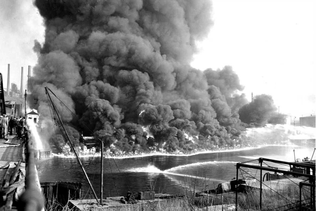
The Cuyahoga River was once one of the most polluted rivers in the United States. It has caught fire a total of 13 times dating back to 1868, including this blaze in 1952 which caused over $1.3 million in damages.
[ https://www.alleghenyfront.org/how-a-burning-river-helped-create-the-clean-water-act/ ]
Peg -- 2024 will be a total eclipse here
Annie Dillard's Classic Essay: 'Total Eclipse'

“Seeing a partial eclipse bears the same relation to seeing a total eclipse as kissing a man does to marrying him.”
RNsidersbuying -- you're obviously enjoying the Trump® combo
Trump® Ecstasy makes partying great again!™

The front of the orange tablets shows Mr Trump's face and exuberant hairstyle while the president's surname is written on the reverse.
25 August 2017
http://www.bbc.com/news/world-europe-41015254
goes great with:
Trump® Ass Gas™

Get Gassed!™
So Beats Having To Know Things And Think, It's Addictive!™
[(linked in) http://investorshub.advfn.com/boards/read_msg.aspx?message_id=133158812 and preceding (and any future following)]
Charlottesville Was The Most Traumatic Event Of My Young Life, But It Won’t Stop Me

I’ve been an activist since I was 13 years old, I’ve been to numerous protests but NOTHING was ever this bad! My physical injuries will eventually heal, but the mental trauma will last forever.
By Nupol Kiazolu
Head of the Youth Coalition for Black Lives Matter of Greater NY
08/21/2017
http://www.huffingtonpost.com/entry/charlottesville-most-traumatic-event-young-life_us_599af592e4b01f6e801feb64 [with comments]
*
KKK Leader Tells Afro-Latina Journalist He’ll ‘Burn’ Her Out Of His Property
Ilia Calderón said she’d “never felt so much hate, so much contempt in my life.” During the interview, Barker told Calderón that she was the first black person to ever set foot on his property. “I’m upset that I’ve seen you,” Barker told her. “I mean, I see you every day — all your type. I’ve been here over 20 years, and we’ve never had a black person or whatever you wanna call yourself, you’re a mongrel to me.” When Calderón defiantly asked if he was going to chase her off the property, he responded by saying: “No, we’re gonna burn you out.” Barker called Calderón a racial slur, which she calmly told him she found “offensive.” At one point he also told her: “Look at your eyes and look at my eyes. I’m way more superior than you’ll ever be.” Calderón asked both Barker and his wife, Amanda, if they were part of a hate group — both rejected the idea and described themselves as a Christian organization.
08/21/2017
http://www.huffingtonpost.com/entry/kkk-leader-tells-afro-latina-journalist-hell-burn-her-off_us_599b17a1e4b0771ecb0633a7 [with embedded videos, and comments]
*
Why Black Women Are Protesting A Statue Of This Famed Gynecologist
J. Marion Sims, the “father of modern gynecology,” has a disturbing history.

J. Marion Sims is known as the “father of modern gynecology,” and his statue currently stands at the New York Academy of Medicine in East Harlem.

J. Marion Sims was a gynecologist in the 1800s who purchased Black women slaves and used them as guinea pigs for his untested surgical experiments. He repeatedly performed genital surgery on Black women WITHOUT ANESTHESIA because according to him, "Black women don't feel pain.” Despite his inhumane tests on Black women, Sims was named “the father of modern gynecology”, and his statue currently stands right outside of the New York Academy of Medicine. #FightSupremacy
[ https://www.facebook.com/BYP100/photos/a.577719128946089.1073741828.576628419055160/1550909888293670 (with {over 18,000} comments)]
08/21/2017
http://www.huffingtonpost.com/entry/why-black-women-are-protesting-a-statue-of-this-famed-gynecologist_us_599adb63e4b0e8cc855ec8c7 [with embedded video, and comments]
*
Law Firm Boots Patent Attorney Who Owns Neo-Nazi Record Label On The Side

The label’s catalog includes a 2010 album called “Behead The Semite.” Then there’s Aryanwulf, whose songs include "Kill the Jews" and "At the Dawn of a New Aryan Empire.“ There’s also the Raunchous Brothers, whose rhyming poetics include such passages as, "You’re of no use to me, you disgraceful fucking dyke, so I’ll shove you in the oven like the glorious Third Reich.”
08/21/2017
http://www.huffingtonpost.com/entry/attorney-fired-neo-nazi-record_us_599b4b0de4b06a788a2b207d [with embedded video, and comments]
--
(linked in):
http://investorshub.advfn.com/boards/read_msg.aspx?message_id=60232115 and (the many) following;
http://investorshub.advfn.com/boards/read_msg.aspx?message_id=123731767 and preceding (and any future following);
http://investorshub.advfn.com/boards/read_msg.aspx?message_id=123777222 and preceding and following;
http://investorshub.advfn.com/boards/read_msg.aspx?message_id=132394623 and preceding and following;
http://investorshub.advfn.com/boards/read_msg.aspx?message_id=132767361 and preceding and following,
http://investorshub.advfn.com/boards/read_msg.aspx?message_id=133607071 and preceding and following
http://investorshub.advfn.com/boards/read_msg.aspx?message_id=133950773 and preceding and following
http://investorshub.advfn.com/boards/read_msg.aspx?message_id=133991457 and preceding (and any future following)
http://investorshub.advfn.com/boards/read_msg.aspx?message_id=133992074 and preceding and following
fastlizzy -- only partial here; no biggie -- sunshine became less bright for a while
we get a total here in 2024 -- that'll be more interesting (been through one before)

