 News
News  Market Data
  Discover
Support: 888-992-3836
Copyright © 2023 InvestorsHub Inc.


Register for free to join our community of investors and share your ideas. You will also get access to streaming quotes, interactive charts, trades, portfolio, live options flow and more tools.
SAD; CHINESE DROPPING LIKE FLIES ...
WATCH
https://www.bitchute.com/video/DMHfhhvpwXu3/
President Trump Rally *Live* ~ Warren, Mi. Sat. 10-1-2022, 7pm EDT.
https://www.rsbnetwork.com/video/watch-president-donald-trump-save-america-rally-live-in-warren-mi-10-1-22/
.jpg)
HURRICANE IAN WAS MAN MADE AND CONTROLLED. HERE IS HOW THEY DID IT. WEATHER WAREFARE
WATCH

https://www.bitchute.com/video/HbBNyu1h7mdI/
Military NWO Weather Weapons HARRP IN ACTION? - Making NWO Depopulation Weather -
WATCH

https://www.bitchute.com/video/1xROVifcrNd6/
Military Weather Weapons – Dane Wigington
By Greg Hunter On August 16, 2022 In Political Analysis 11 Comments
By Greg Hunter’s USAWatchdog.com.
https://usawatchdog.com/radical-drought-caused-by-military-weather-weapons-dane-wigington/


.jpg)


.jpg)
 )
) 


*Trump Rally *Live* ~ Warren, Mi. Sat. 10-1-2022, 7pm EDT.
https://www.rsbnetwork.com/video/watch-president-donald-trump-save-america-rally-live-in-warren-mi-10-1-22/
HURRICANE IAN WAS MAN MADE AND CONTROLLED. HERE IS HOW THEY DID IT. WEATHER WAREFARE
WATCH
https://www.bitchute.com/video/HbBNyu1h7mdI/
Military NWO Weather Weapons HARRP IN ACTION? - Making NWO Depopulation Weather -
WATCH
https://www.bitchute.com/video/1xROVifcrNd6/
Military Weather Weapons – Dane Wigington
By Greg Hunter On August 16, 2022 In Political Analysis 11 Comments
By Greg Hunter’s USAWatchdog.com.
https://usawatchdog.com/radical-drought-caused-by-military-weather-weapons-dane-wigington/
) Anyone know of any hurricane clean up stocks? There used to be some pennies hyping Hurricane affiliation, I think NMSG was one?
Powerful quake strikes off Japan
TOKYO (AP) -- A powerful earthquake struck near remote Japanese islands and shook most of the country Saturday evening, but it occurred well beneath the earth's surface and did not trigger a tsunami warning. Several people suffered non-life-threatening injuries, and there were no reports of deaths or major damage.
The magnitude-8.5 offshore quake struck off the Ogasawara islands at a depth of 590 kilometers (370 miles), the Japan Meteorological Agency said. The U.S. Geological Survey said the quake had a magnitude of 7.8 and a depth of 678 kilometers (421 miles).
The temblor was powerful enough to rattle most of Japan, from the southern islands of Okinawa to Hokkaido in the north. It caused buildings to sway in Tokyo - about 1,000 kilometers (620 miles) north of the Ogasawara islands - and temporarily disrupted some train services in the city. About 400 houses in Saitama prefecture, just north of the capital, were without power, according to the Tokyo Electric Power Co.
At Tokyo's Roppongi Hills shopping and business complex, elevators stopped soon after the earthquake struck the area, forcing hundreds of visitors to climb down the stairs. Among them were about 200 people who came to see the Star Wars exhibit on the 52nd floor.
In Saitama, a woman in her 70s sustained a minor head injury when a ceramic plate fell from a cupboard, local police said. In Kawasaki, just south of Tokyo, a 56-year-old office worker fell down when the quake caught him by surprise and suffered a rib injury, according to Japanese public broadcaster NHK.
Yoshiyuki Sasamoto, a municipal official on Chichijima island, which is part of the Ogasawara island group, told NHK that he initially felt a mild tremor, but when he thought it was over "there was a violent shaking and I couldn't even stand on my feet."
At an inn on the Ogasawara island of Hahajima, furniture shook violently, although nothing fell or broke, innkeeper Michiko Orita told NHK. "It was so frightening. The entire house shook and a Buddhist altar violently swayed like I have never experienced before," she said, adding that all her guests were safe.
The meteorological agency did not issue a tsunami warning because the quake struck so far beneath the earth's surface. Deep offshore earthquakes usually do not cause tsunamis, and generally cause less damage than shallow ones.
In March 2011, a magnitude-9.0 earthquake rocked northeastern Japan, triggering a tsunami that killed more than 18,500 people and ravaged much of the northern Pacific coast. The depth of that quake was just 24 kilometers (15 miles), according to the meteorological agency.
http://www.aol.com/article/2015/05/30/powerful-quake-strikes-off-japan-no-tsunami-warning/21189077/?icid=maing-grid7%7Cmain5%7Cdl11%7Csec1_lnk3%26pLid%3D1051850496
Count
Blackwater Snipers Killed Thousands Of Katrina Victims!
Thursday, July 10, 2014 7:03
http://beforeitsnews.com/alternative/2014/07/blackwater-snipers-killed-thousands-of-katrina-victims-2989736.html
http://notthesingularity.com/2567/did-special-forces-snipers-operate-in-new-orleans-after-katrina/
Three Dead After Strong Quake Shakes Mexico
XICO CITY – A 6.5-magnitude earthquake struck in Mexico's western Guerrero state Saturday night, shaking buildings and causing panic in the nation's capital and the Pacific resort of Acapulco. Officials said at least three people died, but there were no reports of widespread damage.
The U.S. Geological Service initially estimated the quake at magnitude at 6.8, but downgraded it to 6.7 and then 6.5. A quake of that magnitude is capable of causing severe damage, although the depth of this temblor lessened its impact.
The USGS said the quake occurred at a depth of 40.3 miles. It was centered about 26 miles southwest of Iguala in Guerrero and 103 miles south-southwest of Mexico City.
Mexico's Interior Department said the quake was felt in parts of nine states.
Humberto Calvo, undersecretary of Guerrero's Civil Protection agency, said three deaths had been reported in the state. He said one man was killed when a house's roof collapsed in Iguala, a second died in the small town of Ixcateopan and the driver of a cargo truck was killed by rocks that fell on the vehicle driving on the toll highway linking Acapulco with Mexico City.
Calvo said a secondary highway between the two cities was blocked in two places by rockslides.
High-rises swayed in the center of Mexico City for more than a minute, and shoppers were temporarily herded out of some shopping centers until the danger passed.
Mexico City's mayor, Marcelo Ebrard, reported by Twitter that no major damage had been reported. He said power failed in some parts of the city.
People in one part of Mexico City's upscale Condesa neighborhood ran out of their houses and gathered in the streets, hugging each other while some shook and began to cry.
On one street, a group of women joined hands in a circle, closed their eyes and began to pray.
"Please God, help us and let everything be OK," said one. "It's OK. It's OK. Everything is OK."
Parts of Mexico City rest on the shaky soil of a former lake bed, which tends to magnify the effect of earthquakes. An 8.1-magnitude quake in 1985 killed as many as 10,000 people in the city.
In Acapulco, which is in Guerrero, hundreds of anxious tourists congregated in the street after fleeing rocking buildings that are strung along the coastal boulevard. Patrons also left a movie theater complex.
Authorities said they found no structural damage and had no reports of injuries in the Pacific resort, which was about 87 miles from the quake's epicenter.
Rogelio Trujillo, chief of security at a Soriana department store in Acapulco, said perfume bottles, groceries and paintings had been shaken off shelves and customers ran out.
Alberto Orbe, a radio operator for the city's Civil Protection agency, said the office had received many phone calls from panicked residents.
The quake interrupted the annual silver festival in the tourist city of Taxco, midway between Acapulco and the capital.
A deep rumbling sound lasted for several seconds, then the whole city went dark as the ground shook. People ran out of hotels in the historic center of the old mining town and joined others who had been enjoying a band concert in the main plaza.
As people milled about, some illumination was provided from police pickup trucks doing security duty at the festival. After about 10 minutes, the band started up again and people began dancing.
The power was out for about two hours and cellphone service was sporadic. Some people sat on restaurant terraces dining by candlelight and the full moon.
Read more: http://www.foxnews.com/world/2011/12/10/strong-quake-shakes-mexico-city/?test=latestnews#ixzz1gFOmRzah
Correction, that wasn't a aftershock it was a 5.6 earthquake near Sparks Ok.
Oklahoma Earthquake: 5.6 Magnitude Temblor Hits State
11/ 6/11 08:25 AM ET Associated Press
SPARKS, Okla. — Oklahomans more accustomed to tornadoes than earthquakes suffered through a weekend of temblors that cracked buildings, buckled a highway and rattled nerves. One quake late Saturday was the state's strongest ever and jolted a college football stadium 50 miles away and was followed early Sunday by a jarring aftershock.
There were no reports in the hours after the quakes of any severe injuries or major devastation.
"That shook up the place, had a lot of people nervous," Oklahoma State wide receiver Justin Blackmon said of the late Saturday quake, the strongest of a series of quakes. "Yeah, it was pretty strong."
The magnitude 5.6 earthquake Saturday night was centered near Sparks, 44 miles northeast of Oklahoma City, and could be felt throughout the state and in Kansas, Missouri, Arkansas, northern Texas and some parts of Illinois and Wisconsin, said geophysicist Jessica Turner at the U.S. Geological Survey. A magnitude 4.7 quake early Saturday was felt from Texas to Missouri.
Turner told The Associated Press that the subsequent magnitude 4.0 quake that struck at 3:39 a.m. Sunday was an aftershock centered some 36 miles east of Oklahoma City in the same region. Like Saturday night's quake, she said it was another shallow quake occurring about 3 miles underground, but experts had no immediate explanation for the spurt in seismic activity.
Following the quakes or numerous small aftershocks, several homeowners and businesses reported cracked walls, fallen knickknacks and other minor damage. But in Shawnee, the fire department said one spire on the administration building at St. Gregory University had been damaged and another one was leaning, according to KWTV in Oklahoma City.
An emergency manager in Lincoln County near the epicenter said U.S. 62, a two-lane highway that meanders through rolling landscape between Oklahoma City and the Arkansas state line, crumpled in places when the stronger quake struck Saturday night. Other reports Sunday were sketchy and mentioned cracks in some buildings and a chimney toppled.
"Earthquake damage in Oklahoma. That's an anomaly right there," Todd McKinsey of Moore told The Oklahoman newspaper after the magnitude 5.6 temblor centered 50 miles away left him with cracked drywall.
Oklahoma typically has about 50 earthquakes a year, and 57 tornadoes, but a swarm of quakes east of Oklahoma City contributed to a sharp increase in the number of temblors. Researchers said 1,047 quakes occurred last year, prompting them to install seismographs in the area. A cause of the uptick wasn't known.
Saturday night's earthquake jolted Oklahoma State University's stadium shortly after the No. 3 Cowboys defeated No. 17 Kansas State. The crowd of 58,895 was still leaving when it hit, and players were in the locker rooms beneath the stands at Boone Pickens Stadium.
The temblor seemed to last the better part of a minute, rippling upward to the stadium press box.
"Everybody was looking around and no one had any idea," Oklahoma State quarterback Brandon Weeden said. "We thought the people above us were doing something. I've never felt one, so that was a first."
The magnitude 4.7 earthquake that struck the area early Saturday was also widely felt, but emergency officials said no injuries were reported at area hospitals right after that.
"Nothing is destroyed or anything like that," Prague City Police Department dispatcher Claudie Morton told the Tulsa World after the Saturday morning quakes.
A few hours before dawn Sunday, the latest quake set nerves on edge anew.
At the Prague Community Hospital in the region, registered nurse Jessie Plumb said no injured people had come into the emergency room by Sunday morning. But she said she and other hospital staffers felt the 4.0 magnitude quake before dawn while on the second floor of the building.
"It kind of gave a little bit of a shake, a little bit of rock `n roll," she told AP by phone. "I would say it was 20 or 25 seconds." She said she was anxious because of the number of quakes concentrated in her region in so short a span and the fact that they were so strong.
Saturday's late-night quake was slightly less in intensity than a temblor that rattled the East Coast on Aug. 23. That 5.8 magnitude earthquake was centered in Virginia and was felt from Georgia to Canada. No major damage was reported, although cracks appeared in the Washington Monument, the National Cathedral suffered costly damage to elaborately sculpted stonework, and a number of federal buildings were evacuated.
Turner said the Saturday night quake was Oklahoma's strongest on record.
USGS records show that a 5.5 magnitude earthquake struck El Reno, just west of Oklahoma City, in 1952 and, before Oklahoma became a state in 1907, a quake of similar magnitude 5.5 struck in northeastern Indian Territory in 1882.
She said an active spate of quakes began occurring in the region in February 2010 and added the latest activity appears to be part of that trend. She also said the magnitude 4.7 quake early Saturday appeared to be a prelude to Saturday night's more potent quake and Sunday's was an aftershock. "If these are going to continue to happen, we can't predict," she told AP.
But she said experts were still puzzling out why the latest quakes were concentrated in such a small geographic area around Sparks.
"The largest earthquake is a 5.6 and we call that the main shock," she said. "Everything before that 5.6 we consider a foreshock including the 4.7. Everything after the 5.6 we consider an aftershock."
Oklahoma Geological Survey researcher Austin Holland told Oklahoma City television station KOTV that the earthquake and aftershocks occurred on a known fault line.
Residents in Prague and Sparks felt an intense shaking, but for those farther away the quake was more of a dull rumble, he said.
"It shakes much more rapidly when you're closer to it," Holland said. "Because it's a large earthquake, it's going to rumble for a while."
The Prague police dispatcher Morton said her office was swamped with calls, mostly from jittery locals expressing their alarm. She said residents told her that picture frames and mirrors fell from walls and broke, drawers worked loose from dressers and objects tumbled out of cabinets.
"Oh, man. I've never felt anything like that in my life," Morton told the Tulsa newspaper. "It was the scariest thing. I had a police officer just come in and sit down and all the sudden the walls started shaking and the windows were rattling. It felt like the roof was going to come off the police department."
FOLLOW HUFFPOST GREEN ONFacebook:Like 69KTwitter:
Get Alerts CONTRIBUTETO THIS STORYSend Corrections
Send us a Link
Contact us
Send a Tip
Send Photos/Videos
Comment
Copyright 2011 The Local Paper. All rights reserved. This material may not be published, broadcast, rewritten or redistributed.
Tulsa Oklahoma had a 4.7 earthquake earlier this morning.
Tonight about 45 minutes ago we felt a aftershock in Texas.
i live about 20 mins from it and we just had another at about 1:07 am. im so tired, im afraid to go to sleep.
so, im up lurking ihub.
this sucks.
4.5 just hit, i ran out, but this time i was not on my 3rd level.. so it was not as bad as when i was upstairs the first time. but stuff was moved all around upstairs again. our house had some minor damage that is not covered from the first one.
im going to pull my truck out of the garage and keep my garage open in case i need to get out that way. i dont think my house can take this kind of shaking.
I felt it in Atlantic City NJ.
5.9 QUAKE STRIKES VIRGINIA!
http://news.blogs.cnn.com/2011/08/23/quake-hits-near-washington-d-c/
What's Really Going On In Haiti?
So, why are so many of us so quick to believe everything our government
and their toadies in the national media are telling us?
Are we so naïve as to believe that unregenerate politicians in
Washington, D.C., are incapable of the same evil acts of barbarity
and savagery that might be found in other parts of the world?
Are sinners less sinful because they happened to receive their
fallen nature from American bloodlines?.....
http://www.newswithviews.com/baldwin/baldwin564.htm
by Pastor Chuck Baldwin
God Bless
Report: US weapon test aimed at Iran caused Haiti quake
Sat, 23 Jan 2010 10:34:46 GMT
An unconfirmed report by the Russian Northern Fleets says the Haiti earthquake was caused by a flawed US Navy 'earthquake weapons' test before the weapons could be utilized against Iran..?..
bottom lines....
The US government, however, has chosen to stick to its position that HAARP is merely a program aimed at analyzing the Earth's ionosphere for the purpose of developing communications and surveillance technology.
http://www.presstv.ir/detail.aspx?id=116834§ionid=351020104
French minister accuses U.S. of 'occupying ' Haiti....
http://www.digitaljournal.com/article/285993
Report: US weapon test aimed at Iran caused Haiti quake
Sat, 23 Jan 2010 10:34:46 GMT
An unconfirmed report by the Russian Northern Fleets says the Haiti earthquake was caused by a flawed US Navy 'earthquake weapons' test before the weapons could be utilized against Iran.
United States Navy test of one of its 'earthquake weapons' which was to be used against Iran, went 'horribly wrong' and caused the catastrophic quake in the Caribbean, the website of Venezuela's ViVe TV recently reported, citing the Russian report.
After the report was released, Venezuelan President Hugo Chavez also made a similar claim, saying that a US drill, carried out in preparation for a deliberate attempt to cause an earthquake in Iran, had led to the deadly incident in Haiti, claiming more than 110,000 lives.
Though Russian Northern Fleets' report was not confirmed by official sources, the comments attracted special attention in some US and Russian media outlets including Fox news and Russia Today.
Russia Today's report said that Moscow has also been accused of possessing and utilizing such weapons.
In 2002, a Georgian Green Party leader claimed that Moscow had instigated an earthquake on Georgian territory, the TV channel said.
According to ViVe, the unconfirmed Russian report says earlier this month the US carried out a similar test in the Pacific Ocean, which also caused another 6.5 magnitude earthquake in an area near the town of Eureka, California.
The California quake resulted in no deaths or serious injury, but left many buildings damaged.
The Venezuelan news website said that the report also introduced the possibility that the US Navy may have had "full knowledge" of the damage that the test could cause.
The report also speculated that knowledge of the possible outcome was why the US military had pre-positioned the deputy commander of US Southern Command, General P. K. Keen, on the island so that he could oversee relief efforts if the need arose.
Based on the alleged report, the ultimate goal of the US weapons tests was to initiate a series of deadly earthquakes in Iran to topple the current Islamic system in the country.
The tests are believed to be part of the United States' High Frequency Active Auroral Research Program (HAARP), which has been associated with many conspiracy theories.
Other than being blamed for earthquakes, HAARP has also been associated with weather anomalies that cause floods, droughts and hurricanes.
Some sources have even linked the 7.8 magnitude quake that shook the Chinese city of Sichuan in May 12, 2008 with the program.
Allegations have been made that since the late 1970's, the US has 'greatly advanced' the state of its earthquake weapons to the point where it is now utilizing devices that employ a Tesla Electromagnetic Pulse, Plasma and Sonic technology, along with 'shockwave bombs.'
Russia has accused the US military of employing such devices in Afghanistan to trigger the devastating 7.2 magnitude earthquake that hit the country back in March, 2002.
In the mid-1990s the Russian State Duma issued a press release on HAARP, which was signed by 90 deputies. The statement said the US was "creating new integral geophysical weapons that may influence the near-Earth medium with high-frequency radio waves."
"The significance of this qualitative leap could be compared to the transition from cold steel to firearms, or from conventional weapons to nuclear weapons.”
“This new type of weapons differ from previous types in that the near-Earth medium becomes at once an object of direct influence and its component,” the statement explained.
In 1997, US Secretary of Defense William Cohen also expressed concern about activities that "can alter the climate, set off earthquakes, volcanoes remotely through the use of electromagnetic waves."
The US government, however, has chosen to stick to its position that HAARP is merely a program aimed at analyzing the Earth's ionosphere for the purpose of developing communications and surveillance technology.
http://www.presstv.ir/detail.aspx?id=116834§ionid=351020104
Land-building project in Lousiana shuts down
15 minutes ago
(AP:NEW ORLEANS) Six years after the Army Corps of Engineers hailed a land-building project near the mouth of the Mississippi River as a major step in saving coastal Louisiana, the project is being shut down after millions of dollars went into it.
Over the objections of scientists, a panel overseeing the effort to save coastal Louisiana voted Wednesday to close a river diversion at West Bay, a spot about 75 miles south of New Orleans. The cut in the river was supposed to create 10,000 acres of land. However, after six years and $33.3 million in work, it created little to no land.
Directing the Mississippi's flow into Louisiana's sinking coast through diversions is one of the chief methods being looked at to restore the river delta, one of the fastest eroding coastal areas in the world. South Louisiana has lost more than 2,000 square miles of land since the 1930s, an area roughly the size of Delaware.
The failure of the West Bay diversion highlights the problems federal and state governments face as they try to combat sea level rise and land loss. The project is being scrapped for reasons that have plagued other coastal restoration projects: the conflict between coastal restoration and maritime traffic, high costs, and untested scientific and engineering techniques.
The West Bay diversion is being closed because it led to shoaling of an anchorage spot for ships bound for New Orleans near Pilottown. The Army Corps estimated that it would cost more than $100 million to keep the anchorage free of mud; on Wednesday, a special task force said that cost was prohibitive.
Scientists on Thursday said the move was wrong-headed.
"For me, it's a step backward," said John T. Wells, a coastal geologist at the Virginia Institute of Marine Science who sits on a scientific advisory board looking at how to restore the Mississippi River delta.
Wells said closing the diversion was premature and that not enough time had passed to know for sure whether the diversion might have worked.
"From a scientific standpoint, this is a truly unique opportunity to gain an understanding if the diversions are going to be part of the tool bag," Wells said. He said expectations for the project's land-building capacity after six years were unreasonable.
Col. Alvin Lee, the corps' district engineer in New Orleans, said the diversion simply wasn't worth keeping open.
"It's a difficult decision to make but it was the right decision," Lee said. "It comes down to the benefits and costs."
He said the diversion was an experiment when it was constructed in 2003. "This was a study of a diversion and I think we've learned a significant amount from this diversion," Lee said.
Officials said they looked at a variety of alternatives to keep the diversion open, but that they were bound by legal agreements to maintain the Pilottown anchorage.
Sean Duffy, the president of the Gulf States Maritime Association, said the Pilottown anchorage has been in use for a century and serves as an important safe haven for ships, especially those in distress or caught in fog.
"Prior to the diversion being open, the anchorage never needed to be dredged," Duffy said. "Since the diversion, it has been dredged three times."
He said the maritime industry had hoped the diversion would be successful, but that it made no sense to keep it open because it didn't work as it was intended.
John Day, a coastal expert at Louisiana State University, said scrapping the West Bay project showed that coastal restoration was not a priority.
"It still means flood control and navigation have a much higher priority than coastal restoration," Day said. "The projections are that if we don't do anything, most of the coast will disappear. We have to do big things."
Now, officials are looking at diverting Mississippi water farther upriver, where river sediment may do more good and not get swept offshore, as may be happening at West Bay, which is next to the Gulf of Mexico.
"The idea of investigating in diversions farther upriver with better payout is a good decision," said Oliver Houck, a lawyer and coastal restoration expert at Tulane University in New Orleans. "It sort of shows that economic constraints force you to make better decisions."
Miss. court: Hurricane wind damage must be covered
32 minutes ago
(AP:JACKSON, Miss.) Insurance companies must cover damage from a hurricane's wind even if the home is later inundated by storm surge, the Mississippi Supreme Court ruled in a case that a couple filed after Hurricane Katrina.
In its 36-page unanimous ruling Thursday, Justice Michael Randolph said storm damage can be excluded from coverage by language in insurer's homeowner policies when it is caused by a combination of wind and water acting together.
But the court said that the exclusion wouldn't apply in the case that a Long Beach couple, Margaret and Magruder Corban, filed against United Services Automobile Association if it could be determined that wind damage happened first.
The Supreme Court said a jury must decide whether damage to the Corbans' home was caused by wind or water.
Lawyers on both sides said they were pleased.
"There's no question that the decision is a victory for Mississippi homeowners," said Christopher Van Cleave, a lawyer for the Corbans. "That doesn't mean there aren't still battles to be fought."
Paul Berry, a spokesman for San Antonio-based USAA, said the court "confirmed USAA's approach to handling Katrina claims in Mississippi was correct."
"Although other insurers may have taken different approaches, USAA has always paid damage caused solely by wind," he said. "We're also pleased that the court confirmed USAA's position, and decades of insurance law, that damage caused by storm surge is not covered."
Some of the most contentious insurance lawsuits spawned by Katrina dealt with properties that were reduced to slabs, making it difficult to determine if wind or water was responsible.
Insurance companies say their homeowner policies cover damage by a hurricane's wind but not its rising water, including wind-driven storm surge. Insurers also have maintained that damage from a combination of wind and flood water can be excluded from coverage by "anti-concurrent cause" language in their policies.
In a case against State Farm Fire and Casualty Co. after Katrina, U.S. District Judge L.T. Senter Jr. in Gulfport, Miss., ruled that this clause is ambiguous and couldn't be enforced. In 2007, however, the 5th U.S. Circuit Court of Appeals in New Orleans reversed Senter's ruling and upheld the policy language in that case.
Joseph Lavitt, a Berkeley Law School professor who teaches insurance law, said the Supreme Court disagreed with part of the 5th Circuit's ruling but didn't address whether insurers are liable for damage "when either the wind or the water could have caused the loss without the other and they acted at the same time."
"The Corbans' battle is far from over. Either party may yet prevail under today's ruling," he said.
getting rocked ...


Looks like the first named storm of this year's hurricane season is forming in the Caribbean. Good time to buy National Storm Management (NSMG).
Rhino
4.7 in California last night.
http://www.nbclosangeles.com/news/local/Earthquake-Rattles-Hawthorne-Area.html
another a.s.
3.3 Magnitude Quake
Rocks North Texas
Published : Saturday, 16 May 2009, 12:17 PM CDT
North Texas - An earthquake shook several North Texas Cities just before 11:30 this morning.
The U.S. Geological Society reported the 3.3 magnitude quake was felt in Dallas, Arlington, Hurst, Bedford and Euless. FOX 4 also received numberous calls, some from viewers in Irving who said they felt the quake. One woman who called in from Bedford reported feeling a shudder for about 3 seconds.
The last earthquake to hit North Texas was on October 31of 2008, and centered in Irving. That quake measured a magnitude 3.0 according to the U.S. Geological Society. Around the same time, another 2.5 magnitude quake centerd in Grand Prairie.
and now an aftershock
Magnitude 3.3 - NORTHERN TEXAS
2009 May 16 16:24:06 UTC
DetailsMapsWhere can I find...?
Earthquake Details
Magnitude 3.3
Date-Time Saturday, May 16, 2009 at 16:24:06 UTC
Saturday, May 16, 2009 at 11:24:06 AM at epicenter

Location 32.796°N, 97.091°W
Depth 5 km (3.1 miles) set by location program
Region NORTHERN TEXAS
Distances 6 km (4 miles) S (179°) from Euless, TX
7 km (4 miles) SE (141°) from Bedford, TX
9 km (6 miles) ESE (118°) from Hurst, TX
11 km (7 miles) NNE (16°) from Arlington, TX
28 km (18 miles) W (269°) from Dallas, TX
Location Uncertainty horizontal +/- 9 km (5.6 miles); depth fixed by location program
Parameters NST= 11, Nph= 11, Dmin=44.5 km, Rmss=0.86 sec, Gp= 94°,
M-type="Nuttli" surface wave magnitude (mbLg), Version=6
Source U.S. Geological Survey, National Earthquake Information Center:
World Data Center for Seismology, Denver
Event ID us2009gsba
http://earthquake.usgs.gov/eqcenter/recenteqsus/Maps/US2/32.34.-98.-96.php
Useful Information About Electro Magnetic Fields -
How Do I Measure EMFs?
A Gauss is a common unit of measurement of magnetic field strength. A Gauss meter is an instrument which measures the strength of magnetic fields. Inside a Gauss meter there is a coil of thin wire, typically with hundreds of turns. As a magnetic field radiates through the coil, it induces a current, which is amplified by the circuitry inside the Gauss meter.
Gauss meters may vary in the strength of the magnetic field they are capable of measuring. A meter used for measuring EMFs from power lines, transformers, substations and appliances around the home, for example, should be able to measure as low as .1 mg.
Gauss meters vary widely in price and accuracy. Meters have either a single axis coil or a triple axis coil. Single axis meters are much simpler than triple axis meters to manufacture and thus, are less expensive.
To use a single axis meter you must point the meter’s one sensor in three directions — -the x, y and z axis. Then, you combine the three readings in a mathematical equation to calculate the combined field strength. Obviously, its far easier and more accurate to use a 3-axis meter. Triple axis Gauss meters are quite accurate, but they are also more expensive.
Another thing to watch out for when purchasing or renting a Gauss meter is whether or not it is frequency weighted. Most meters will read the same EMF strength no matter what the frequency.
As the human body appears to be sensitive to both the field strength AND the frequency, Gauss meters used for biological purposes should be “frequency weighted”.
This means that if the field is different than 60 Hz the meter will consider the frequency and use it in calculating and displaying the EMF’s strength. This feature is why frequency weighted meters will show a higher EMF reading than those meters typically used by electricians and engineers.
http://www.healthfreedomusa.org/?p=503
Earth's Magnetic Field Reversal Puzzle Almost Complete -
by Mitch Battros - Earth Changes Media
Saturday, May 02, 2009
This is what I have been looking for over the past four years.
I believe it to be the missing piece which comes close to completing the puzzle. This could explain both the scientific theory of pole reversals, and Mayan prophecy of 2012.
Yes--- I believe this new scientific study is extraordinarily significant.
New studies reveal the Earth's magnetic field is not produced by a "dipole" alone. Study results and historical paleomagnetic data point to something called "quadrupolar".
First let's start with what is widely known and accepted (at least until now). Most every geo-scientist (if not all) agree the production of Earth's magnetic field is based on the "dipole theory". (see diagram below)
http://www.freedomsphoenix.com/Find-Freedom.htm?EdNo=001&At=0056193
La. signs $30 million Road Home contract -
9 minutes ago
(AP:BATON ROUGE, La.) Louisiana will pay up to $30 million
to the new contractor running the Road Home program
that doles out grants to homeowners with damage
from hurricanes Katrina and Rita, under a two-year
contract released Thursday by the Louisiana Recovery Authority.
The state announced in February that Hammerman and Gainer Inc.,
based in Lutcher, will manage the program, taking over
from heavily criticized ICF International Inc.
Hammerman and Gainer, one of ICF's largest subcontractors
working on the Road Home, took control of the program
April 20, the state recovery authority said in a statement.
The contract with the company includes 19 performance standards,
and the company faces fines for errors in files and for
not meeting certain benchmarks.
For example, Hammerman and Gainer must have a final error
rate of less than 5 percent or face a $10,000 fine for
each percentage point above that, according to the contract.
The Road Home has handed out $7.9 billion in grants to
more than 124,000 homeowners, from federal aid given
to Louisiana after Katrina and Rita struck in 2005.
ICF, the Fairfax, Va.-based company hired by former Gov. Kathleen Blanco's administration,
has been paid more than $867 million for its work so far,
but critics said homeowners were treated poorly and often
given less money than they should have received.
Rather than renew a contract with ICF, Gov. Bobby Jindal's
administration broke up the components of the Road Home
and solicited bids for new companies. Contractors other
than Hammerman and Gainer will collect and store Road Home
data and run a separate Road Home program to help
repair small rental property.
Virginia-based CGI Technologies and Solutions Inc.
will receive up to $40 million for providing Road Home data
storage and technology services for other hurricane recovery programs.
ACS State & Local Solutions Inc., based in Dallas, will
be paid up to $37.5 million to run the slow-moving program
to help small landlords rebuild rental property.
Whoa! 7.9 Mag earthquake TONGA REGION...
Event Page
MAP 4.9 2009/03/20 02:10:38 -22.862 -174.802 35.0 TONGA REGION
MAP 5.3 2009/03/19 20:33:58 -23.290 -174.623 35.0 TONGA REGION
MAP 7.9 2009/03/19 18:17:40 -23.021 -174.700 34.0 TONGA REGION
MAP 5.0 2009/03/16 15:25:20 -20.651 -175.775 81.1 TONGA

10-degree Map Centered at 25°S,175°W

Depth 34 km (21.1 miles) set by location program
Tectonic Summary
The broad-scale tectonics of the earthquake region are dominated by the relative convergence of the Pacific and Australia plates. The Pacific plate subducts westward beneath the Australia plate at the Tonga trench. At the latitude of the earthquake, the Pacific plate moves westward with respect to the interior of the Australia plate at a velocity of about 77 mm/year. The eastern edge of the broad Australia plate may itself be viewed as a collection of small plates or microplates that move with respect to each other and with respect to the Pacific plate and the Australia plate interior. In terms of numbers of earthquakes, the broad-scale Australia/ Pacific plate boundary is one of the most active in the world. Earthquakes occur on the thrust-fault boundary between the Australia and Pacific plates, within the Pacific plate, and within and on the boundaries of the small plates that together compose the eastern edge of the overall Australia plate.
http://www.prh.noaa.gov/ptwc/?region=0
Tsunami warning center has it listed as 7.7
 TSUNAMI BULLETIN NUMBER 003
 PACIFIC TSUNAMI WARNING CENTER/NOAA/NWS
 ISSUED AT 2008Z 19 MAR 2009

 THIS BULLETIN APPLIES TO AREAS WITHIN AND BORDERING THE PACIFIC
 OCEAN AND ADJACENT SEAS...EXCEPT ALASKA...BRITISH COLUMBIA...
 WASHINGTON...OREGON AND CALIFORNIA.

 ... TSUNAMI WARNING CANCELLATION ...

 THE TSUNAMI WARNING AND/OR WATCH ISSUED BY THE PACIFIC TSUNAMI
 WARNING CENTER IS NOW CANCELLED FOR

  TONGA / NIUE / KERMADEC IS / AMERICAN SAMOA / SAMOA /
  WALLIS-FUTUNA / FIJI

 THIS BULLETIN IS ISSUED AS ADVICE TO GOVERNMENT AGENCIES.  ONLY
 NATIONAL AND LOCAL GOVERNMENT AGENCIES HAVE THE AUTHORITY TO MAKE
 DECISIONS REGARDING THE OFFICIAL STATE OF ALERT IN THEIR AREA AND
 ANY ACTIONS TO BE TAKEN IN RESPONSE.

 AN EARTHQUAKE HAS OCCURRED WITH THESE PRELIMINARY PARAMETERS

  ORIGIN TIME -  1818Z 19 MAR 2009
  COORDINATES -  23.0 SOUTH  174.8 WEST
  DEPTH       -   10 KM
  LOCATION    -  TONGA ISLANDS REGION
  MAGNITUDE   -  7.7

 MEASUREMENTS OR REPORTS OF TSUNAMI WAVE ACTIVITY

  GAUGE LOCATION        LAT   LON    TIME        AMPL         PER
  -------------------  ----- ------  -----  ---------------  -----
  NIUE                 19.1S 169.9W  1911Z   0.04M /  0.1FT  06MIN

  LAT  - LATITUDE (N-NORTH, S-SOUTH)
  LON  - LONGITUDE (E-EAST, W-WEST)
  TIME - TIME OF THE MEASUREMENT (Z IS UTC IS GREENWICH TIME)
  AMPL - TSUNAMI AMPLITUDE MEASURED RELATIVE TO NORMAL SEA LEVEL.
         IT IS ...NOT... CREST-TO-TROUGH WAVE HEIGHT.
         VALUES ARE GIVEN IN BOTH METERS(M) AND FEET(FT).
  PER  - PERIOD OF TIME IN MINUTES(MIN) FROM ONE WAVE TO THE NEXT.

 EVALUATION

  SEA LEVEL READINGS INDICATE A TSUNAMI WAS GENERATED. IT MAY HAVE
  BEEN DESTRUCTIVE ALONG COASTS NEAR THE EARTHQUAKE EPICENTER. FOR
  THOSE AREAS - WHEN NO MAJOR WAVES ARE OBSERVED FOR TWO HOURS
  AFTER THE ESTIMATED TIME OF ARRIVAL OR DAMAGING WAVES HAVE NOT
  OCCURRED FOR AT LEAST TWO HOURS THEN LOCAL AUTHORITIES CAN ASSUME
  THE THREAT IS PASSED. DANGER TO BOATS AND COASTAL STRUCTURES CAN
  CONTINUE FOR SEVERAL HOURS DUE TO RAPID CURRENTS. AS LOCAL
  CONDITIONS CAN CAUSE A WIDE VARIATION IN TSUNAMI WAVE ACTION THE
  ALL CLEAR DETERMINATION MUST BE MADE BY LOCAL AUTHORITIES.

  NO TSUNAMI THREAT EXISTS FOR OTHER COASTAL AREAS IN THE PACIFIC
  ALTHOUGH SOME OTHER AREAS MAY EXPERIENCE SMALL SEA LEVEL CHANGES.
  THE TSUNAMI WARNING IS NOW CANCELLED FOR ALL AREAS COVERED BY
  THIS CENTER.

 THIS WILL BE THE FINAL BULLETIN ISSUED FOR THIS EVENT UNLESS
 ADDITIONAL INFORMATION BECOMES AVAILABLE.

 THE WEST COAST/ALASKA TSUNAMI WARNING CENTER WILL ISSUE PRODUCTS
 FOR ALASKA...BRITISH COLUMBIA...WASHINGTON...OREGON...CALIFORNIA.
 __________________________________________________________________________
TSUNAMI MESSAGE NUMBER   3
 NWS PACIFIC TSUNAMI WARNING CENTER EWA BEACH HI
 1009 AM HST THU MAR 19 2009

 TO - CIVIL DEFENSE IN THE STATE OF HAWAII

 SUBJECT - FINAL TSUNAMI ADVISORY

 THE TSUNAMI ADVISORY IS ENDED FOR THE STATE OF HAWAII EFFECTIVE
 AT 1009 AM HST.

 AN EARTHQUAKE HAS OCCURRED WITH THESE PRELIMINARY PARAMETERS

    ORIGIN TIME - 0818 AM HST 19 MAR 2009
    COORDINATES - 23.0 SOUTH  174.8 WEST
    LOCATION    - TONGA ISLANDS REGION
    MAGNITUDE   - 7.7  MOMENT

 MEASUREMENTS OR REPORTS OF TSUNAMI WAVE ACTIVITY

  GAUGE LOCATION        LAT   LON    TIME        AMPL         PER
  -------------------  ----- ------  -----  ---------------  -----
  NIUE                 19.1S 169.9W  1911Z   0.04M /  0.1FT  06MIN

  LAT  - LATITUDE (N-NORTH, S-SOUTH)
  LON  - LONGITUDE (E-EAST, W-WEST)
  TIME - TIME OF THE MEASUREMENT (Z IS UTC IS GREENWICH TIME)
  AMPL - TSUNAMI AMPLITUDE MEASURED RELATIVE TO NORMAL SEA LEVEL.
         IT IS ...NOT... CREST-TO-TROUGH WAVE HEIGHT.
         VALUES ARE GIVEN IN BOTH METERS(M) AND FEET(FT).
  PER  - PERIOD OF TIME IN MINUTES(MIN) FROM ONE WAVE TO THE NEXT.

 EVALUATION

  THE PACIFIC TSUNAMI WARNING CENTER HAS CANCELLED THE REGIONAL
  TSUNAMI WARNING IT ISSUED FOR ANOTHER PART OF THE PACIFIC. BASED
  ON ALL AVAILABLE DATA THERE IS NO DESTRUCTIVE TSUNAMI THREAT TO
  HAWAII AND THE ADVISORY FOR HAWAII IS ALSO CANCELLED.

  HOWEVER... SOME COASTAL AREAS IN HAWAII COULD EXPERIENCE SMALL
  NON-DESTRUCTIVE SEA LEVEL CHANGES AND STRONG OR UNUSUAL CURRENTS
  LASTING UP TO SEVERAL HOURS. THE ESTIMATED TIME SUCH EFFECTS
  MIGHT BEGIN IS

                      0236 PM HST THU 19 MAR 2009

 THIS WILL BE THE FINAL MESSAGE ISSUED FOR THIS EVENT UNLESS
 ADDITIONAL DATA ARE RECEIVED.
Ruminations on Ike: Why is it that my power is on?
An Inner Loop resident ponders the whimsy of fate and electrons in Ike's wake
By ROBERT I. MOORE
Copyright 2008 Houston Chronicle
Sept. 14, 2008, 10:19PM
I live in an older neighborhood, inside the 610 Loop and close to the Texas Medical Center, where quaint bungalows are torn down and million-dollar McMansions are constructed. It's a nice place to live.
After enduring the drama of Hurricane Ike early Saturday and monitoring the endless news coverage, I looked out my window and saw an elderly neighbor across the street wrestling with a half-fallen branch in the rain. Like a 50-year-old Eagle Scout, I ran over to give him assistance, hoping he would not injure himself.
Then, I learned that neighbors on the other side of my street did not have any power and that their power may be out for days.
During the early hours of the hurricane, my power had gone off spasmodically. I remember once, while looking out in the darkness at the house across the street, seeing deep blue flashes of light in the night sky. I thought that this was some strange type of lightning, but no — it was electrical transformers being knocked out by the force of the hurricane.
Before the storm, I thought to myself — whatever happens, I do not want to lose electricity!
I felt confident in my older home, which my family has lived in since 1938 and which has weathered many storms in the past. Growing up, I remember Hurricane Carla in 1961. I was in this house during Alicia, Allison, Rita and now Ike. I did board up some of the home's more venerable windows with limited materials.
During the night we did lose power — oh no! For about an hour or so we were in the dark, and then miraculously our lights came back on. Thank you very much!
On Saturday, after assisting my neighbor, I was drenched with rain and perspiration. I had spent this day of rest working blisters into my hands beginning the endless cleanup after Ike's fury subsided. On Saturday night I first learned that, unfortunately, several million in the Houston area had lost their power. The paper said more than 99 percent. Unbelievable! My parents, my wife's parents, family members, close friends — all were without power!
I had offered my fully powered home to my parents and other family members, but none of them came. I couldn't help but wonder: Why were we so fortunate when even my neighbors across the street were without power?
On Sunday morning, I approached my neighbors across the street offering whatever assistance I could give them. Two weeks earlier, I had purchased a couple bags of ice when Hurricane Gustav was brewing. I still had them. Prior to this hurricane, I had grabbed the Ozarka plastic water bottles from the recycling bin. I had filled them with water and put them in the freezer.
When I approached one of my neighbors, he gratefully accepted the supplies of ice and the frozen Ozarka water bottles.
I made it a point to keep in touch with family and friends all through the hurricane weekend, continually offering them assistance.
Sunday afternoon, my mother called to tell me their power was back on in Sharpstown. My dad had just had surgery at M.D. Anderson one week earlier. I was glad to hear that!
One of my siblings has power, and she lives in Sugar Land. Two others do not. One lives in Spring and is a Harris County sheriff's deputy.
The other lives at FM 1488 and I-45, just south of Conroe.
Some of my close friends are enduring the aftermath of Ike without electricity as well.
My wife's family is without power, too. They live in the Inwood area between 290 and 249, in northwest Houston. They are here and staying with us on Sunday night. My wife's sister and her husband rode out the hurricane with us in the house together. He works for the city of Sugar Land and has been working from daylight till dark since the storm subsided. She is pregnant and due in two weeks.
Now as Sunday closes, I sit on my front porch with my dog, sipping a margarita and listening to the emergency sirens in the background as military helicopters fly over. I can hear the buzz of chain saws in the distance.
I can't help but wonder: Why do I have electricity when my neighbors and so many others do not?
Moore, a native Houstonian, grew up in Sharpstown and graduated from Texas A&M. He works for Ambrose, McEnany and House, Architects. Readers can e-mail him at rimoore7@gmail.com.
http://www.chron.com/disp/story.mpl/editorial/outlook/6001639.html
Second Hand Ike Storm Stories:
1. Port Aransas - We had 4 feet of water in the house at the peak. Had to wade out to the dock to check on the boats, and all okay. Lots to do to clean this mess up. Corpus had 20 foot waves on Friday. Haven't seen that in years. We were a long way from where Ike hit land, so this was really a shocker for us.
2. Galveston -- My house was in the middle of the island. We don't know if it's destroyed, but we think it's just the first floor that was lost underwater. People are saying that most of the homes on our street were flooded, but are still standing. We are in SA now trying to get back; we heard that the G bridge has re-opened. UTMB is operational, but limited. I lost my car and motorcycle for sure, and most of my personal stuff was moved up the the second floor expecting this. Not sure what we will find when we get there... it's really sad, but I don't know what Galveston will be like when we get back. Don't know how the island can recover from this.
Salvation Army, American Red Cross Ask For Donations
Organizations' Relief Funds Take Financial Hit From Ike, Gustav
POSTED: 6:17 pm CDT September 14, 2008
UPDATED: 6:59 pm CDT September 14, 2008
FORT WORTH, Texas -- Back-to-back hurricanes Gustav and Ike have put a financial strain on thousands of evacuees -- and the organizations that provide assistance to them.
The American Red Cross and the Salvation Army work together to help people in times of need.
"They provide the shelter, we provide the food," a Salvation Army volunteer said.
The American Red Cross says its disaster relief fund faces a significant shortfall. Hurricane Gustav alone is expected to cost the organization about $70 million, and only 3 percent of that amount has been raised.
"Our disaster relief fund is lower than it's been in a long time," said Betsey Edmond, of the American Red Cross.
People can donate their loose change to the American Red Cross Relief Fund at Kroger grocery stores across North Texas. Donations can also be made by visiting www.redcross.org or calling 800-RED-CROSS.
The Salvation Army said it is also facing financial challenges because of the recent hurricanes.
"Our disaster resources are being depleted," Maj. Henry Gonzalez said.
The Salvation Army spends $53,000 a day providing three square meals to evacuees.
While some people may want to donate food, Gonzalez said financial donations make it easier for the Salvation Army to purchase the materials it needs.
Edmond also said monetary donations are preferred.
"The ARC has great partners, so we are able to stretch that dollar further than someone else can," she said.
It's also a question of logistics -- the Salvation Army doesn't have the warehouse space to keep non-perishable items.
The American Red Cross says North Texans can help by volunteering and donating money and blood.
Those interested in donating their time to local shelters should contact the American Red Cross. People who haven't previously volunteered can learn about training dates, times and locations at The Red Cross' Web site at www.redcrossdfw.org or its blog at www.redcrossdfwdisaster.wordpress.com
People who want to volunteer in other ways can contact the Volunteer Center of North Texas at 866-797-8268 or www.vcnt.org.
The Red Cross also says it is in need of blood donations. A blood mobile will be set up at the Dallas Area Chapter at 4800 Harry Hines Blvd. on Monday from noon to 5 p.m.
Donors can also visit the American Red Cross Blood Center at 1 Medical Parkway in Farmers Branch from 11 a.m. to 7 p.m. on Monday or schedule a blood donation by calling 800-GIVE LIFE or visiting www.givelife.org.
Evacuees said they appreciate the work done by the Red Cross and the Salvation Army.
Cedrea Townsend, an evacuee from Houston, said the people with the organizations are "real sweet and kind."
"They're very important, because we don't have nothing," she said. "We came with nothing, and they've helped us out."
re: Galveston and Ike -- this type of story will be making news for weeks. A lot of people expected the weak right turn -- and it was too little too late
God taught me lesson’ about taking Ike lightly
Galveston County Daily News - 1 hour, 0 minute ago
GALVESTON — Fletcher Harris, 85, always told anyone who would listen that he’s not the type of man who flees from a hurricane.
UBS says blood supply is critical
Blood supplies don't usually get used up at a faster rate during a hurricane than they do at any other time. But there is almost always a serious shortage of blood during and after a hurricane, as there is right now at United Blood Services.
That's because the people who normally donate are busy with storm preparation, cleanup or evacuation.
"Some of the strongest donor groups are in Erath and Delcambre and they're the ones who are usually hardest hit," said Susan Begnaud, executive director of United Blood Services.
Blood drives, which normally bring in a good portion of donations, are often canceled, as they were in advance of hurricanes Gustav and Ike.
"Another thing that hit us hard and will hit again this week," Begnaud said, "we have five locations - Lafayette, Baton Rouge, Thibodaux, Slidell and Morgan City, which have been greatly affected by the storms."
It takes a steady stream of donations - about 200 pints a day - to keep up with local needs. That dwindled to less than 100 pints a day in the past 10 days.
Although blood drives have been canceled last week, the UBS donor center has been open. Drives scheduled for the coming week will be held, if the facilities holding them are open, Begnaud said.
http://theadvertiser.com/apps/pbcs.dll/article?AID=/20080914/LIFESTYLE/809140325
Effects of Hurricane Ike in Texas
http://en.wikipedia.org/wiki/Effects_of_Hurricane_Ike_in_Texas
Contents [hide]
1 Hurricane preparations
2 Surge lower than predicted landfall
3 Aftermath
3.1 Galveston
3.2 Houston
3.3 Texas City
3.4 League City
3.5 Kemah, Seabrook and El Lago
3.6 Clear Lake and Nassau Bay
3.7 Corpus Christi
3.8 Other towns
3.9 Offshore ships and oil rigs
4 See also
5 Notes
6 References
7 External links
Ike did turn right and weaken, as almost all Texas hurricanes have done for years.
Unfortunately, the turn east and the weakening were too late and the intensity level did not decrease enough to spare Galveston Island. Galveston was hit harder than Carla and Alison. The surge water level was higher. Ike wiped out older structuctres that outlived both of those storms, according to reports.
For Crystal Beach and the Bolivar Peninsula, the late turn not only didn't help, it helped push water from G bay right over the Bolivar Peninsula and essentially wiped out 90% of the structures in Crystal Beach. This is really sad. Crystal Beach was a really, really beautiful place.
There are other communities that are impacted seriously -- about 10% of the 5 county area near Houston has electricity as I type this.
It's a slow motion disaster so far, however, because the worst news is yet to come from southeast of Houston.
Hurricane IKE at landfall - image

Hurricane Ike From Wikipedia, the free encyclopedia
http://en.wikipedia.org/wiki/Hurricane_Ike_(2008)
Hurricane Ike was the ninth named storm, and fifth hurricane of the 2008 Atlantic hurricane season.[1] It was a Cape Verde-type hurricane, as it started as a tropical disturbance off the coast of Africa near the end of August, then tracked south of Cape Verde and slowly developed. On September 1, it became a tropical storm west of the Cape Verde islands.[2][3] By the early morning hours of September 4, Ike was a Category 4 hurricane, hitting its peak of 145 mph (230 km/h) winds and a pressure of 935 mbar (27.61 inHg). That made it the most intense storm so far in the 2008 Atlantic hurricane season. At one point the diameter of Ike's tropical storm and hurricane force winds were 450 and 190 miles (720 and 305 km), respectively. Ike has been blamed for 101 deaths since its formation, primarily in Haiti, which was already trying to recover after the impact of three prior 2008 systems, Fay, Gustav, and Hanna. Damages from Ike are estimated at $27 billion (2008 USD)[4]
This image should be in the iBox of this thread, imo
Hurricane Ike
http://en.wikipedia.org/wiki/2008_Atlantic_hurricane_season
A tropical disturbance developed off the coast of Africa near the end of August. It tracked south of Cape Verde and slowly developed. On September 1 it became Tropical Depression Nine while west of the Cape Verde islands, it then intensified into a tropical storm, and was named Ike by the NHC. Ike developed an eye late on September 3 as it underwent explosive intensification, as it strengthened from a tropical storm to a Category 4 hurricane in twelve hours with an estimated pressure drop of 43 millibars (1.3 inHg), from 991 to 948 millibars (29.3 to 28.0 inHg); and a 24 hour pressure drop of 61 millibars (1.8 inHg), from 996 to 935 millibars (29.4 to 27.6 inHg). Ike weakened back to a Category 2 hurricane before re-intensifying back to Category 4 as confirmed by reconnaissance flight reports. It ripped across Grand Inagua Island and Grand Turk Island, where 80% of the buildings on that island were severely damaged or completely destroyed. It weakened into a strong Category 3 late in the afternoon of September 7 as it headed for landfall on the northeastern coastline of Cuba that evening.[23] In addition, the storm has killed at least 75 people in Haiti and 1 person in the Dominican Republic.[24]
By 5 a.m. EDT on September 8, Ike had weakened to a Category 2 while over Cuba, and to a category 1 shortly afterwards. It crossed into the Gulf of Mexico by 5 P.M. EDT on September 9, and was expected to make landfall between Surfside Beach, Texas and Crystal Beach, Texas, by early Saturday, September 13. The highest probability landfall point between San Luis Pass and the west end of Galveston had not changed within the last 24 hours (10 PM CDT, September 12, 2008). Massive flooding of Galveston Island had already occurred with many homes on the west end (not protected by seawall) already destroyed by a massive storm surge well in advance of the storm. As many as 13 houses or buildings were on fire, unable to be handled because of dangerous conditions. On Bolivar Peninsula, Texas dozens of people were rescued as flood waters exceeded 12 feet (3.7 m) above sea level. Flooding was also being seen in the region of Galveston bay.
Many large waves had already topped the Galveston Seawall which is 16 feet (4.9 m) above sea level. On top of an expected surge as high as 22 feet (6.7 m) near the important oil and gas refineries along the Houston Ship Channel, ocean waves as high as 20 feet (6.1 m) were expected along the coast. Ike later moved inland, and later that day weakened into a tropical storm. Damage from Ike is estimated at $27 billion (2008 USD), the third most destructive US Hurricane on record, behind 1992's Andrew and 2005's Katrina. [25] At least 99 deaths have been blamed on Ike.
2008 Atlantic hurricane season
http://en.wikipedia.org/wiki/2008_Atlantic_hurricane_season
The 2008 Atlantic hurricane season is an ongoing event in the annual cycle of tropical cyclone formation. The season officially started on June 1 and will run through November 30. These dates conventionally delimit the period of each year when most tropical cyclones form in the Atlantic basin, though the season began slightly early when Tropical Storm Arthur formed off the coast of Belize on May 30. The season has begun far more active than normal and has been particularly devastating for Haiti, where hundreds of people were killed by four straight tropical cyclones in August and September, which were named Fay, Gustav, Hanna, and Ike.
Golden Triangle Weather Hurricane info
http://www.ih2000.net/ira/bmt-wth.htm
Oriented towards Gulf of Mexico & Caribbean, but you can click on the images or other links to get info about other areas.
They don't know if they like Ike.
Unusual earthquakes measured off Oregon
By JEFF BARNARD, Associated Press Writer
2 hours, 50 minutes ago
http://news.yahoo.com/s/ap/20080412/ap_on_sc/earthquake_swarm_9;_ylt=AlLPWr9cf_sBDlCJAWv0skkE1vAI
GRANTS PASS, Ore. - Scientists listening to underwater microphones have detected an unusual swarm of earthquakes off central Oregon, something that often happens before a volcanic eruption — except there are no volcanoes in the area.
Scientists don't know exactly what the earthquakes mean, but they could be the result of molten rock rumbling away from the recognized earthquake faults off Oregon, said Robert Dziak, a geophysicist for the National Oceanic and Atmospheric Administration and Oregon State University.
There have been more than 600 quakes over the past 10 days in a basin 150 miles southwest of Newport. The biggest was magnitude 5.4, and two others were more than magnitude 5.0, OSU reported.
On the hydrophones, the quakes sound like low thunder and are unlike anything scientists have heard in 17 years of listening, Dziak said. Some of the quakes have also been detected by earthquake instruments on land.
The hydrophones are left over from a network the Navy used to listen for submarines during the Cold War. They routinely detect passing ships, earthquakes on the ocean bottom and whales calling to one another.
Scientists hope to send out an OSU research ship to take water samples, looking for evidence that sediment has been stirred up and chemicals that would indicate magma is moving up through the Juan de Fuca Plate, Dziak said.
The quakes have not followed the typical pattern of a major shock followed by a series of diminishing aftershocks, and few have been strong enough to be felt on shore.
The Earth's crust is made up of plates that rest on molten rock, which are rubbing together. When the molten rock, or magma, erupts through the crust, it creates volcanoes.
That can happen in the middle of a plate. When the plates lurch against each other, they create earthquakes along the edges.
In this case, the Juan de Fuca Plate is a small piece of crust being crushed between the Pacific Plate and North America, Dziak said.
The Dominican Reblublic is still trying to rebuild after the latest Hurricane.
Deep Blue Marine investors are collecting the following donations to be sent to the Dominican Reblublic:
50 hammers, regular old hammers (no wooden handles)
500 lbs nails (16 and 8 pennies)
300 sheets corigated roofing tin; 2.5 by 8 feet
40 rolls chicken wire, 3 ft
linens (sheets, pillow cases, towels, washcloths etc) as much as possible
100 cot mattresses
10 shovels (spade point)
soap
cleaning products
utensils, unbreakable forks, knives, plates, spoons, dishes, cups, tuperware, etc. (non disposable)
string, spools of twine, fish string, hemp, etc. as much as we can get
buckets; 5 gallon
basic sewing supplies, scissors, needles, thread
bolts of fabric, all kinds; canvas, etc
diapers; all sizes, disposable
clothing
men:
heavy working jeans, cotton work shirts, undershirts
women:
dresses, jeans, nice shirts
children:
regular kids clothing
shoes
enough baseball equipment to outfit two whole teams: gloves, balls, bats, hats, uniforms, etc.
100 basic first aid kits: band aids, neosporin, alcohol wipes, etc. already assembled is best
generic medicines
fever reducers
cold relievers
children vitamins
toiletry items: toothbrushes, toothpaste, feminine products, etc.
if in fact you are going to donate an item please contact either me or wayne and let us know the quantity, the product, and where you are at in the country (your address), we will let you know where to send it. i believe that i have posted my email allready but just in case: kerriblum@hotmail.com.
my cell phone is 801-750-7765, you can get me almost 24-7 on that. Wayne can be contacted by private message to waterboy. or you can private message Rustys mate and I will pass the information on and get back to you as to where to send the donation in your city or state.
There it is, let's get going, everything is handled as far as getting through customs, distribution will be handled soon. LET'S DO IT!!!!!!!!!!
We would appreciate everyone helping where ever they can. Perhaps emailing this information to family and friends.
This is to benefit those people in the Dominican Republic. Some of whom have lost everything they had, others just no insurance and no money to rebuild.
Please PM waterboy or Rustys mate if you are able to donate anything.
hey guys, going to add this board link to my new board as well!
just found it today!
Flossie heads for Hawaii
By JAYMES SONG, Associated Press Writer
Public schools closed and Hawaiians were warned to stock up on food and water as Hurricane Flossie roared toward the state early Tuesday. As if the storm wasn't enough, an 5.3 magnitude earthquake jolted the Big Island of Hawaii overnight.
The eye of the Category 3 storm, with maximum winds reaching 115 mph, was expected to pass less than 100 miles from the islands and bring strong winds and heavy rain.
The weather service placed the Big Island under a hurricane watch and a tropical storm warning. A flash flood watch was also issued for the island through Wednesday, with possible flash flooding in areas.
Gov. Linda Lingle signed an emergency disaster proclamation, which activates the Hawaii National Guard. Mayor Harry Kim also declared a state of emergency Monday as a precaution. All 56 public schools, as well as private schools, on the Big Island also were closed for Tuesday.
Just as preparations for the storm were under way, Hawaii got another scare: A magnitude 5.3 earthquake struck about 25 miles south of Hilo. There were no reports of injuries or damage in the Monday night quake, although it did cause a small landslide, according to Tom Brown, a spokesman for Hawaii County Civil Defense.
The Big Island is largely rural, with about 150,000 people, and most live in the west or northeast, not the southern portion expected to be hit hardest by the hurricane. Other islands are expected to get much less of the storm's wind and rain.
At 5 a.m. EDT, Flossie was about 260 miles south-southeast of Hilo and 455 miles southeast of Honolulu, the Central Pacific Hurricane Center said. The storm was moving west-northwest at about 15 mph.
Hurricane force winds of at least 74 mph extended outward up to 40 miles from the center of the storm, while tropical storm force winds of at least 39 mph extend outward up to 155 miles.
Meteorologists cautioned that even a slight change of course in the unpredictable storm could take it closer to land.
"We're not out of it, but this is too close for comfort," said Maj. Gen. Robert Lee, state adjutant general and Hawaii National Guard commander.
The move also provides access to emergency money.
Forecasters earlier had said cooler weather would weaken the storm to a Category 1 hurricane, with sustained wind of at least 74 mph, by the time it passes about 90 miles south of the Big Island of Hawaii on Tuesday.
But on Monday forecasters said they now expected a Category 3 hurricane, with little change in strength when it passes the island. Earlier in the day, Flossie had been a Category 4 storm with maximum sustained winds of 140 mph.
"The intensity has remained stronger than what was originally forecast, but the track has been pretty much right on," said Jim Weyman, the National Weather Service's meteorologist in charge in Honolulu.
Officials strongly urged residents statewide to prepare, including having a supply of food, water and disaster plans.
"If Flossie misses us, that's great. But we're still in hurricane season," said Ray Lovell, spokesman for the state Civil Defense Agency.
Parts of the Big Island, home to one of the world's most active volcanoes in Kilauea, likely will experience tropical storm-level winds and at least 10 to 15 inches of rain, Weyman said.
The last time a hurricane hit Hawaii was in 1992, when Iniki ravaged Kauai, killing six people and causing $2.5 billion in damage.
Meanwhile, a tropical depression in the far Eastern Atlantic — the fourth of the season — was 855 miles west-southwest of the southernmost Cape Verde Islands and about 1,660 miles east of the Lesser Antilles. It had maximum sustained winds at 35 mph and was moving at 21 mph.
Hurricane season runs from June 1 to Nov. 30. In May, forecasters said the Hawaiian Islands and the rest of the central Pacific faced a slightly below-average hurricane season, with just two or three tropical cyclones expected because of lower sea surface temperatures.
This is not so useful, but is from the source page. Proof that in life, there is no such thing as a "guarantee." Hurricanes are equal opportunity destroyers.
http://www.nhc.noaa.gov/pastprofile.shtml
Atlantic hurricane
http://en.wikipedia.org/wiki/Atlantic_hurricane
This is a great link and one I highly recommend!

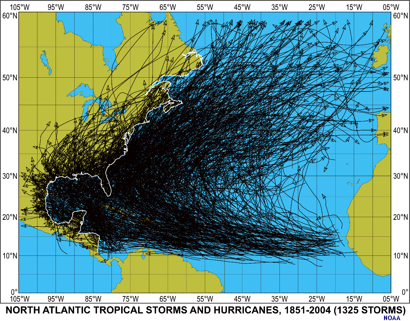
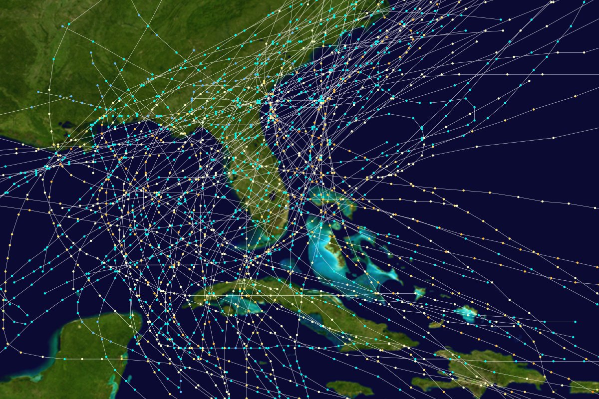
List of Florida hurricanes (1975-1999)
http://en.wikipedia.org/wiki/List_of_Florida_hurricanes_%281975-1999%29
Tracks of hurricanes over Florida from 1975 to 1999

List of Florida hurricanes (1950-1974)
http://en.wikipedia.org/wiki/List_of_Florida_hurricanes_%281950-1974%29
Tracks of hurricanes over Florida from 1950 to 1974

List of Florida hurricanes (1900-1949)
http://en.wikipedia.org/wiki/List_of_Florida_hurricanes_%281900-1949%29
Tracks of hurricanes over Florida from 1851 to 1899
http://en.wikipedia.org/wiki/List_of_Florida_hurricanes_%28pre-1900%29
Will take a while to load:
yup.
buying more candles.
auntie em????!!!!!!!!!!!
It looks like next month is the big one for chi-town. Get psyched!
Tornadoes in Chicago, by month

Tornadoes in Chicago, by time of day

1955-2006 from http://www.sws.uiuc.edu/atmos/statecli/Tornado_v2/chicagoarea.htm
|
Followers
|
13
|
Posters
|
|
|
Posts (Today)
|
0
|
Posts (Total)
|
1642
|
|
Created
|
08/28/05
|
Type
|
Free
|
| Moderator Burpzilla | |||
| Assistants SeriousMoney | |||
 ============================
Hurricane Katrina:
============================
Hurricane Katrina:

 Local newspapers, good articles/photos:
New Orleans Times-Picayune: http://www.nola.com
Jackson Clarion-Ledger: http://www.clarionledger.com/apps/pbcs.dll/frontpage
Biloxi Sun Herald: http://www.sunherald.com/mld/sunherald
How to Help: http://www.investorshub.com/boards/read_msg.asp?message_id=7836741
View the Front Pages of 41 countries, 406 newspapers: http://www.newseum.org/todaysfrontpages
Watch for the next storm: http://www.nhc.noaa.gov
Local newspapers, good articles/photos:
New Orleans Times-Picayune: http://www.nola.com
Jackson Clarion-Ledger: http://www.clarionledger.com/apps/pbcs.dll/frontpage
Biloxi Sun Herald: http://www.sunherald.com/mld/sunherald
How to Help: http://www.investorshub.com/boards/read_msg.asp?message_id=7836741
View the Front Pages of 41 countries, 406 newspapers: http://www.newseum.org/todaysfrontpages
Watch for the next storm: http://www.nhc.noaa.gov
| Volume | |
| Day Range: | |
| Bid Price | |
| Ask Price | |
| Last Trade Time: |


