Project Mohole was an ambitious attempt to drill through the Earth's crust into the Mohorovicic discontinuity, and to provide an Earth science complement to the high-profile Space Race. The project was initially led by the American Miscellaneous Society (AMSOC) with funding from the National Science Foundation (NSF). ------ One of the six submerged buoys used for dynamic positioning in Project Mohole. They were lowered to about 200 feet into a circular pattern. The CUSS I would then use sonar to manoeuvre itself in the centre of that circle.
Phase One was executed in spring 1961. Five holes were drilled off the coast of Guadalupe Island, Mexico, the deepest to 601 ft (183 m) below the sea floor in 11,700 ft (3,600 m) of water. This was unprecedented: not in the hole's depth but because of the depth of the ocean and because it was drilled from an untethered platform. Also, the core sample proved valuable, penetrating through Miocene-age sediments for the first time to reveal the lowest 13 m (44 ft) consisting of basalt.
Project Mohole contracted with Global Marine of Los Angeles for the use of its oil drillship CUSS I. A consortium of Continental, Union, Superior and Shell Oil Companies, CUSS had originally developed it in 1956 as a technological test bed for the nascent offshore oil industry. CUSS I was one of the first vessels in the world capable of drilling in water depth up to 11,700 ft (3,600 m), while maintaining a position within a radius of 600 ft (180 m). Project Mohole expanded its operational range by inventing what is now known as dynamic positioning.
Phase One proved that both the technology and expertise were available to drill into the Earth's mantle. It was intended as the experimental phase of the project, and did succeed in drilling to a depth of 601 feet below the sea floor.[1] However, deeper drilling never took place: an attempted shift of operational control to NSF proved unsatisfactory, AMSOC dissolved itself, phase two of the project was abandoned and the entire project discontinued by Congress, objecting to increasing costs in 1966.
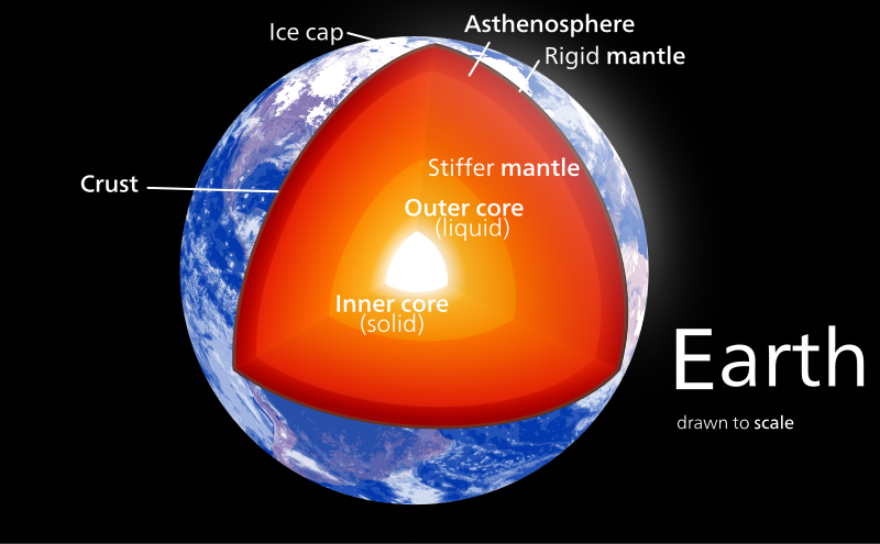
The interior structure of the Earth is layered in spherical shells, like an onion. These layers can be defined by either their chemical or their rheological properties. Earth has an outer silicate solid crust, a highly viscous mantle, a liquid outer core that is much less viscous than the mantle, and a solid inner core. Scientific understanding of Earth's internal structure is based on observations of topography and bathymetry, observations of rock in outcrop, samples brought to the surface from greater depths by volcanic activity, analysis of the seismic waves that pass through Earth, measurements of the gravity field of Earth, and experiments with crystalline solids at pressures and temperatures characteristic of Earth's deep interior.
This post was inspired by a call to Australian radio by an anti-global warming 'scientist' (he said he was) who said the earth's core was cooling. The scientist being interviewed on the radio asked the 'scientist' why he thought that. The 'scientist' said, "that's accepted science, isn't it?" The scientist said no.
In his explanation the scientist mentioned the Mohole project.
 Market Data
  Markets