Monday, December 09, 2013 10:54:58 PM
http://www.satelliteviews.net/cgi-bin/w.cgi?c=ke&UF=-2254033&UN=-3111436&DG=PLN
http://itouchmap.com/?c=ke&UF=-2254033&UN=-3111436&DG=PLN
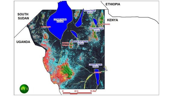
The proximity and in-trend relationship between the Lotikipi plain and the Abu Gabra Rift basins of southern Sudan suggest high oil and gas prospectivity. The southern Sudan basins are established petroleum provinces.Surface exposures of the sedimentary units with potential source and reservoir value, represented by the Cretaceous/Paleogene Lapur Formation of the Turkana Grits, give an indication of the sediments that might be encountered beneath the Lotikipi plain.
Gravity data, acquired earlier in the area, enabled the delineation of a sedimentary basin within the Block 11A area below the Lotikipi plain. The basin-fill is believed to be in excess of 5,000 meters, well above the threshold for sufficiently buried and mature organic matter for oil generation.

Recent ERHE News
- Form SC 13G - Statement of acquisition of beneficial ownership by individuals • Edgar (US Regulatory) • 02/06/2024 07:31:22 PM
- Form 8-K - Current report • Edgar (US Regulatory) • 12/08/2023 09:06:42 PM
Mass Megawatts Announces $220,500 Debt Cancellation Agreement to Improve Financing and Sales of a New Product to be Announced on July 11 • MMMW • Jun 28, 2024 7:30 AM
VAYK Exited Caribbean Investments for $320,000 Profit • VAYK • Jun 27, 2024 9:00 AM
North Bay Resources Announces Successful Flotation Cell Test at Bishop Gold Mill, Inyo County, California • NBRI • Jun 27, 2024 9:00 AM
Branded Legacy, Inc. and Hemp Emu Announce Strategic Partnership to Enhance CBD Product Manufacturing • BLEG • Jun 27, 2024 8:30 AM
POET Wins "Best Optical AI Solution" in 2024 AI Breakthrough Awards Program • POET • Jun 26, 2024 10:09 AM
HealthLynked Promotes Bill Crupi to Chief Operating Officer • HLYK • Jun 26, 2024 8:00 AM


