


Monday, January 11, 2010 5:54:32 PM
fuagf -- a very active area
=====
Recent Earthquakes on California's North Coast
Updated January 23, 1997
http://www.humboldt.edu/~geology/earthquakes/recent_eqks.html
Significant California Earthquakes
http://www.conservation.ca.gov/CGS/rghm/quakes/Pages/eq_chron.aspx
=====
right at the south end
=====

[ http://www.humboldtcounty.com/cats.php?cat=59#RoutesMap ]

[via http://en.wikipedia.org/wiki/Humboldt_County,_California ]
=====
of the Cascadia Subduction Zone
=====

[(from/more at) http://www.pnsn.org/HAZARDS/CASCADIA/cascadia_zone.html ]
=====
scene of recurrent giant megathrust earthquakes
=====
Giant earthquakes beneath Canada's West coast
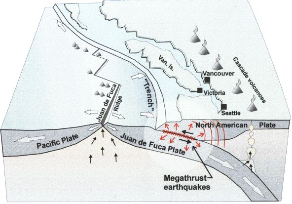
Figure 1.
The Juan de Fuca plate is produced by spreading at the Juan de Fuca ridge several hundred kilometres offshore. It moves landward and beneath the continent at an average rate of 40 mm/yr. Great earthquakes occur on the thrust fault contact. Cascade volcanoes such as Mt. Garibaldi and Mt. St. Helens are produced by melting above the downgoing plate where it reaches a depth of about 100 km.
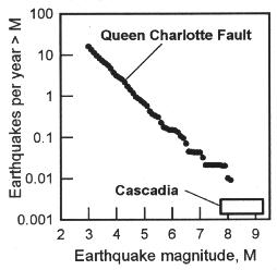
Figure 2.
Earthquakes produced by most fault zones follow the Gutenberg-Richter relation. The av erage number of earthquakes per year decreases with increasing magnitude. The Queen Charlotte transform (strike-slip) fault zone along the coast to the north of Vancouver Island is typical. The Cascadia thrust fault is unusual in that it produces no small earthquakes, only infrequent very large events.

Figure 3.
The Juan de Fuca plate lies offshore between Vancouver Island and northern California. Complex sub-plates are present at its north and south ends. The San Andreas transform fault extends to the south and the Queen Charlotte fault to the north. The barbed line marks where the subduction thrust fault approaches the sea floor. The Cascadia volcanoes (triangles) are limited to the region where the Juan de Fuca plate is underthrusting the continent. The stars mark M~7 historical earthquakes.
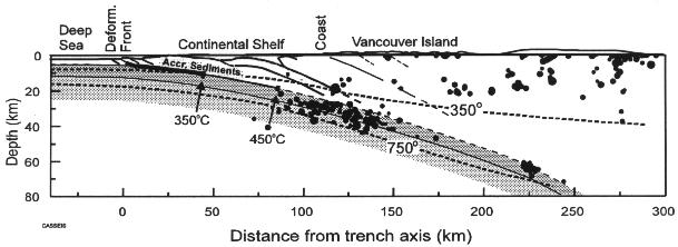
Figure 4.
Earthquakes are common in the continental crust of the northern Cascadia coastal region at depths less than 35 km, which corresponds to a maximum temperature of about 350°C. "Wadati-Benioff " earthquakes occur to a greater depth within the downgoing oceanic plate (to about 750°C) . However, no earthquakes have been detected on the subduction thrust fault. The circle sizes are proportional to the earthquake magnitudes.

Figure 5.
A trench cut through a coastal intertidal marsh exposes a peat layer, the remains of a former, now buried, marsh. The marsh abruptly subsided 1/2-1 m in a great earthquake about 300 years ago. The sand above the buried peat layer was swept into the subsided coastal region by the waves of the resulting great tsunami (after Clague and Bobrowsky, 1994a).

Figure 6.
6 m long core sample taken from the deep sea floor shows fine grained mud layers alternating with sandier layers. The latter are interpreted to have been deposited from submarine landslides triggered by g reat earthquakes. The mud layers formed by the slow continuous rain of finer sediment settling from the ocean. The volcanic ash at the bottom is dated as 7700 years old (after Adams, 1990).

Figure 7:
Top: Uplift and shortening, Bottom: Subsidence, extension, and rupture. Elastic deformation builds up between great earthquakes if the thrust fault is locked. The seaward edge of the continent is dragged down and a flexural bulge forms farther landward. During a great earthquake, there is uplift of the seaward edge and collapse of the flexural bulge. The abrupt uplift generates the tsunami, and the collapse of the bulge causes the subsidence recorded in buried coastal marshes.

Figure 8:
With the thrust fault locked, the 40 mm/yr convergence of the Juan de Fuca plate is taken up as elastic shortening across the continental margin. GPS measurements show Victoria to be moving landward at a rate of 7 mm/yr with respect to the stable North American continent (Penticton site) (after Dragert and Hyndman, 1995). The remainder of the shortening is across the continental shelf.

Figure 9:
Top: Uplift rates from levelling (small symbols) and tide gauges (large symbols) for three coastal regions of the Cascadia margin. Three model uplift profiles are shown for comparison (40+40 km etc. are the dimensions of the locked and transition zones). (Middle) Uplift rates from N. Cascadia compared to southwest Japan. The model curves are the predictions for the temperature-controlled locked and transition zones shown in cross-section in the lower diagram (bottom).

Figure 10:
Locations of the geodetic data that constrain the current deformation associated with the locked subduction thrust fault. The thick solid lines are repeated levelling, the squares are tide gauges, and the boxes are distance survey networks. The dashed lines mark the depth to the top of the subducting plate.

Figure 11:
Plan view of the extent of the locked and transition zones on the subduction thrust fault based on current deformation data.

Figure 12:
Cross-section through the northern Cascadia margin showing the geological structure and isotherms (lines of constant temperature). The landward limits of the locked and transition zones corresponds to temperatures of about 350°C and 450°C respectively.
[from/more at] http://gsc.nrcan.gc.ca/geodyn/mega_e.php [and http://earthquakescanada.nrcan.gc.ca/zones/cascadia/megafig-eng.php ]
---
Megathrust Earthquake - The Strain Build-Up
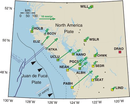
Using the Global Positioning System (GPS) of satellites, and a network of permanent GPS receivers, the relative motion of points on the earth's surface can be monitored at the level of a few millimetres per year. The arrows in this diagram show the measured annual rates and directions of motion of specific sites of the Western Canada Deformation Array (WCDA) relative to a reference site located at the Dominion Radio Astrophysical Observatory (DRAO) south of Penticton. Points on the outer coast of the North American Margin, which overly the locked portion of the Cascadia Subduction Zone, move at rates of over 10 mm/yr in a north-easterly direction. The fact that inland sites move at half that rate, or less, indicates that the outer margin is slowly being compressed like a giant spring. At the time of the next great earthquake it is expected that the accumulated compression will be totally released and that the outer coast of southern Vancouver Island will move up to 5 metres to the south-west.
More information on monitoring crustal deformation can be found on the Geodynamics Site [ http://www.pgc.nrcan.gc.ca/geodyn/_redirect_geodyn.html ].
http://earthquakescanada.nrcan.gc.ca/zones/cascadia/strain-eng.php
---
more at/via "Giant megathrust earthquakes", http://earthquakescanada.nrcan.gc.ca/zones/cascadia/mega-eng.php
=====
all of which is to set the stage for the following more recent developments in Cascadia Subduction Zone megathrust earthquake research -- first, re frequency, at least in the southern extent of the Zone:
=====
Big earthquake coming sooner than we thought, Oregon geologist says

Rob Witter, coastal geologist with the Oregon Department of Geology and Mineral Industries, looks for possible sand deposited by a tsunami in bog of Sitka spruce near Ecola Creek outside Cannon Beach. He was with a video crew from Oregon Public Broadcasting's "Oregon Field Guide" for a story that will air in October.
Oregon Department of Geology and Mineral Industries
By Jacob Arnold, The Oregonian
April 19, 2009, 9:32PM
The good news: New research is giving scientists a better handle on when the big one might strike the Pacific Coast.
The bad news: It probably will be sooner than we thought.
"The amount of devastation is going to be unbelievable," says Rob Witter, coastal geologist with the Oregon Department of Geology and Mineral Industries. "People aren't going to be ready for this. Even if they are prepared, they are going to be surprised by the level of devastation."
Witter spoke last week about the latest in earthquake and tsunami studies -- it's Earthquake and Tsunami Awareness Month -- as part of state and local efforts to educate the public on preparing for a megaquake of magnitude 9 or more. Witter and James Roddey, spokesman for the state agency, also will give a public talk Tuesday in Newport.
Witter says scientists are now in wide agreement that there's a 10 to 14 percent chance a powerful earthquake and tsunami will strike the Oregon coast in the next 50 years.
Why do they think that? The latest findings come from Chris Goldfinger, director of the Active Tectonics and Seafloor Mapping Lab at Oregon State University, Roddey says. But to understand Goldfinger's work, Roddey goes back to what he calls "one of the great scientific detective stories of the 20th century."
Twenty-five years ago, scientists didn't think the Cascadia subduction zone -- a place 50 to 75 miles off Oregon where two of the Earth's plates meet, one sliding under the other -- could produce earthquakes.
That changed after Brian Atwater, a renowned geologist with the U.S. Geological Survey, began in the mid-1980s to study earthquakes, eventually tracing a theory all the way to Japan, Roddey says.
Atwater studied a "ghost forest" -- dead trees in a tidal marsh -- by the Copalis River in Washington, and theorized that a megaquake had killed the cedars. But he needed more evidence.
That came when Japanese researchers published a paper in 1996 about a tsunami that struck Japan on Jan. 27, 1700. Atwater was so intrigued that he learned the language and traveled to Japan.
In 2003, he and a team of Japanese researchers published the book "The Orphan Tsunami" about their theory that the last megaquake struck the Oregon coast Jan. 26, 1700, spawning the tsunami that washed over Japan hours later.
"This was the final puzzle piece that convinced everyone we had the potential for great earthquakes," Roddey says. Work to understand just how great has gone on ever since.
Enter Goldfinger, the OSU researcher. "Chris has been able to go back 10,000 years, and by studying offshore landslides, he found that we've had about 20 of these magnitude 9-plus subduction zone earthquakes where the whole 600-mile-long fault ruptures," Roddey says.
Then he found 18 other quakes magnitude 8 to 8.5 in the southern part of the subduction zone. "So instead of 20 subduction zone earthquakes, we're up to 38," Roddey says.
And, Witter says, instead of thinking giant quakes occur every 500 years, Goldfinger's work puts the cycle at 300 to 350 years.
"We've almost doubled the probability of these events happening," Roddey says. "It just gives a whole lot more urgency to educate the folks at the coast that, 'Hey, you got to get ready.'"
Native Americans, Roddey says, have known this for centuries. Inhabiting the coast for 10,000 years, they passed stories of big quakes from generation to generation.
"They created a cultural tradition by retelling these events and legends," Roddey says. "We see that around the world. When the Sumatra earthquake struck (the Indian Ocean), the Andaman Islands were right in the middle of the rupture zone. There was huge ground shaking, but very few people died from the tsunami because they had also created this culture of awareness. They went to high ground. They survived the event."
Though the Sumatra and Cascadia subduction zones differ, Witter says, a tsunami here would be much the same.
"The geology and numerical models predict tsunamis could reach as high as 80 to 100 feet in Oregon, which is similar to the tsunami that struck Sumatra," Witter says. "We need to be very cautious and prepare for that event. It may not happen in a person's lifetime, but if it does, it's going to be equivalent to a Katrina-like event."
That doesn't mean we need to live in fear, though.
"Once you get prepared and you know where high ground is, once you've talked to your family about an emergency plan and talked about all those kinds of things, you've done your homework. You don't have to think about it again."
© 2009 Oregon Live LLC (emphasis added)
http://www.oregonlive.com/news/index.ssf/2009/04/big_earthquake_coming_sooner_t.html [with comments]
=====
and second, re just where they occur:
=====
Major Offshore Quake Could Surge Inland to Seattle Area
ScienceDaily (Jan. 2, 2010) — Large megathrust earthquakes occur on average every 550 years on the northern Cascadia subduction zone, where the Juan de Fuca tectonic plate subducts underneath the North American plate off the coast of Washington State. Scientists had thought that major earthquakes were likely to occur only offshore, but a new analysis by Chapman and Melbourne shows that a giant earthquake could extend deeper along the subduction zone, and thus farther inland.
The authors analyzed 15 small, nonearthquake periodic slip events known as episodic tremor and slip (ETS) detected between 1997 and 2008 to develop a model of seismogenic coupling between the two tectonic plates.
Their model accurately predicts the deformation of the overlying North American plate as measured by Global Positioning System stations and shows that seismic stress accumulation reaches to about 25 kilometers (15.5 miles) depth, or about 60 km (37.3 mi) inland, rather than stopping offshore at about 15 km (9.3 mi) depth, as had been thought. This indicates that the Seattle metropolitan areas could be subject to a magnitude 8.9 earthquake (from just the Washington State segment of Cascadia).
The authors conclude that results point to a need to reassess the Cascadia megathrust seismic hazard.
The research is published in Geophysical Research Letters. Authors include James S. Chapman and Timothy I. Melbourne: Department of Geological Sciences, Central Washington University, Ellensburg, Washington, USA
Copyright © 2010 ScienceDaily LLC (emphasis added)
http://www.sciencedaily.com/releases/2009/12/091230183449.htm
---
Scientist discovers tremor site closer to Seattle
By Sandra McCulloch, Times Colonist
December 16, 2009
The location of imperceptible earth tremors has a U.S. scientist suggesting Seattle could be at greater risk of damage from a major earthquake than previously thought.
The spot where the Pacific and Juan de Fuca plates are locked together is likely around 65 kilometres from Seattle, not 130 kilometres as previously thought, said Kenneth Creager, a University of Washington researcher at the annual meeting of the American Geophysical Union.
The location of locked plates gives seismologists an idea of where the next major earthquake will occur and the extent of damage it might cause, said John Cassidy, a seismologist with Natural Resources Canada.
The telltale “tremor and slip” events occur between the Pacific and Juan de Fuca plates every 14 to 15 months at various points off Vancouver Island, Cassidy said.
Over the 14 or so months, Vancouver Island “slips” slowly toward the mainland. Then, over two weeks, it changes direction and moves away a few millimetres, resulting in slow-moving tremors. The movements are too small to be felt, but they’re picked on up seismographs at the Pacific Geoscience Centre in Sidney.
“Our tremors that we can record are not earthquake tremors but a very distinct kind of shaking that is well recorded on Vancouver Island,” Cassidy said.
“We can locate those tremors quite accurately now and we have a good idea where they are occurring. Most of them tend to be very close to Victoria and the west coast of Vancouver Island. They continue up to Port Alberni and also northern Vancouver Island.”
The next episodic tremor will occur next summer. The tremor phase tends to align with the occurrence of bigger earthquakes, Cassidy said.
Tremor and slip movements are also evident in Japan, Cassidy said. A 1944 earthquake in Japan was contained to an area where tremors had been recorded.
“What they found was that the earthquake energy was limited to the region offshore of the tremors.”
While it’s one thing to learn where an earthquake will take place, it’s quite another to predict with accuracy when it will happen.
“We have earthquakes that occur in the North American plate, but we also have earthquakes in the ocean plate that is slipping beneath us.
“Then we also have these giant earthquakes offshore. They’re the rarest kinds of earthquakes but they’re the biggest.”
© Copyright (c) The Victoria Times Colonist (emphasis added)
http://www.timescolonist.com/news/Scientist+discovers+tremor+site+closer+Seattle/2345245/story.html
---
Tremors Between Slip Events: More Evidence of Great Quake Danger to Seattle

Seattle skyline with Mount Rainier in the background.
(Credit: iStockphoto/Natalia Bratslavsky)
ScienceDaily (Dec. 16, 2009) — For most of a decade, scientists have documented unfelt and slow-moving seismic events, called episodic tremor and slip, showing up in regular cycles under the Olympic Peninsula of Washington state and Vancouver Island in British Columbia. They last three weeks on average and release as much energy as a magnitude 6.5 earthquake.
Now scientists have discovered more small events, lasting one to 70 hours, which occur in somewhat regular patterns during the 15-month intervals between episodic tremor and slip events.
"There appear to be tremor swarms that repeat, both in terms of their duration and in where they are. We haven't seen enough yet to say whether they repeat in regular time intervals," said Kenneth Creager, a University of Washington professor of Earth and space sciences.
"This continues to paint the picture of the possibility that a megathrust earthquake can occur closer to the Puget Sound region than was thought just a few years ago," he said.
The phenomenon, which Creager discussed during a presentation at the annual meeting of the American Geophysical Union, is the latest piece of evidence as scientists puzzle out exactly what is happening deep below the surface near Washington state's populous Interstate 5 corridor. He noted that the work shows that tremor swarms follow a size distribution similar to earthquakes, with larger events occurring much less frequently than small events.
The Cascadia subduction zone, where the Juan de Fuca tectonic plate dips beneath the North American plate, runs just off the Pacific coast from northern California to the northern edge of Vancouver Island in British Columbia. It can be the source of massive megathrust earthquakes on the order of magnitude 9 about every 500 years. The last one occurred in 1700.
The fault along the central Washington coast, where the Pacific and Juan de Fuca plates are locked together most of the time but break apart from each other during a powerful megathrust earthquake, was believed to lie 80 miles or more from the Seattle area. But research has shown that the locked zone extends deeper and farther east than previously thought, bringing the edge of the rupture zone beneath the Olympic Mountains, perhaps 40 miles closer to the Seattle area. It is this locked area that can rupture to produce a megathrust earthquake that causes widespread heavy damage, comparable to the 2004 Indian Ocean earthquake or the great Alaska quake of 1964.
Episodic tremor and slip events appear to occur at the interface of the plates as they gradually descend beneath the surface, at depths of about 19 to 28 miles. The smaller tremors between slip episodes, what Creager refers to as inter-episodic tremor and slip events, appear to occur at the interface of the plates a little farther east and a few miles deeper.
"There's a whole range of events that take place on or near the plate interface. Each improvement in data collection and processing reveals new discoveries," Creager said.
Episodic tremor and slip events often begin in the area of Olympia, Wash., and move northward to southern Vancouver Island over a three-week period, but scientists have yet to pin down such patterns among the smaller tremors that occur between the slip events.
Because the two tectonic plates are locked together, stress builds at their interface as they collide with each other at a rate of about 4 centimeters (1.6 inches) a year. The slip events and smaller tremors ease some of that stress locally, Creager said, but they don't appear to account for all of it.
"Each one of these slip events puts more stress on the area of the plate boundary where megathrust earthquakes occur, which is shallower and farther to the west, bringing you closer to the next big event," he said. "There's nothing to tell you which one will be the trigger."
Since the slip events and intervening small tremors don't accommodate all of the stress built up on the fault, scientists are getting a better idea of just what the hazard from a megathrust earthquake is in the Seattle area. One benefit from that is the ability to revise building codes so structures will be better able to withstand the immense shaking from a great quake, particularly if the source is substantially closer to the city than it was previously expected to be.
"We'd like to go back and see how much slip has occurred in these slip events, compared to how much should have occurred," Creager said. "Then we'll know how much of that slip will have to be accommodated in a megathrust earthquake, or through other processes."
Copyright © 2009 ScienceDaily LLC (emphasis added)
http://www.sciencedaily.com/releases/2009/12/091215131332.htm [with comments]
=====
Recent Earthquakes on California's North Coast
Updated January 23, 1997
http://www.humboldt.edu/~geology/earthquakes/recent_eqks.html
Significant California Earthquakes
http://www.conservation.ca.gov/CGS/rghm/quakes/Pages/eq_chron.aspx
=====
right at the south end
=====

[ http://www.humboldtcounty.com/cats.php?cat=59#RoutesMap ]
[via http://en.wikipedia.org/wiki/Humboldt_County,_California ]
=====
of the Cascadia Subduction Zone
=====

[(from/more at) http://www.pnsn.org/HAZARDS/CASCADIA/cascadia_zone.html ]
=====
scene of recurrent giant megathrust earthquakes
=====
Giant earthquakes beneath Canada's West coast

Figure 1.
The Juan de Fuca plate is produced by spreading at the Juan de Fuca ridge several hundred kilometres offshore. It moves landward and beneath the continent at an average rate of 40 mm/yr. Great earthquakes occur on the thrust fault contact. Cascade volcanoes such as Mt. Garibaldi and Mt. St. Helens are produced by melting above the downgoing plate where it reaches a depth of about 100 km.

Figure 2.
Earthquakes produced by most fault zones follow the Gutenberg-Richter relation. The av erage number of earthquakes per year decreases with increasing magnitude. The Queen Charlotte transform (strike-slip) fault zone along the coast to the north of Vancouver Island is typical. The Cascadia thrust fault is unusual in that it produces no small earthquakes, only infrequent very large events.

Figure 3.
The Juan de Fuca plate lies offshore between Vancouver Island and northern California. Complex sub-plates are present at its north and south ends. The San Andreas transform fault extends to the south and the Queen Charlotte fault to the north. The barbed line marks where the subduction thrust fault approaches the sea floor. The Cascadia volcanoes (triangles) are limited to the region where the Juan de Fuca plate is underthrusting the continent. The stars mark M~7 historical earthquakes.

Figure 4.
Earthquakes are common in the continental crust of the northern Cascadia coastal region at depths less than 35 km, which corresponds to a maximum temperature of about 350°C. "Wadati-Benioff " earthquakes occur to a greater depth within the downgoing oceanic plate (to about 750°C) . However, no earthquakes have been detected on the subduction thrust fault. The circle sizes are proportional to the earthquake magnitudes.

Figure 5.
A trench cut through a coastal intertidal marsh exposes a peat layer, the remains of a former, now buried, marsh. The marsh abruptly subsided 1/2-1 m in a great earthquake about 300 years ago. The sand above the buried peat layer was swept into the subsided coastal region by the waves of the resulting great tsunami (after Clague and Bobrowsky, 1994a).

Figure 6.
6 m long core sample taken from the deep sea floor shows fine grained mud layers alternating with sandier layers. The latter are interpreted to have been deposited from submarine landslides triggered by g reat earthquakes. The mud layers formed by the slow continuous rain of finer sediment settling from the ocean. The volcanic ash at the bottom is dated as 7700 years old (after Adams, 1990).

Figure 7:
Top: Uplift and shortening, Bottom: Subsidence, extension, and rupture. Elastic deformation builds up between great earthquakes if the thrust fault is locked. The seaward edge of the continent is dragged down and a flexural bulge forms farther landward. During a great earthquake, there is uplift of the seaward edge and collapse of the flexural bulge. The abrupt uplift generates the tsunami, and the collapse of the bulge causes the subsidence recorded in buried coastal marshes.

Figure 8:
With the thrust fault locked, the 40 mm/yr convergence of the Juan de Fuca plate is taken up as elastic shortening across the continental margin. GPS measurements show Victoria to be moving landward at a rate of 7 mm/yr with respect to the stable North American continent (Penticton site) (after Dragert and Hyndman, 1995). The remainder of the shortening is across the continental shelf.

Figure 9:
Top: Uplift rates from levelling (small symbols) and tide gauges (large symbols) for three coastal regions of the Cascadia margin. Three model uplift profiles are shown for comparison (40+40 km etc. are the dimensions of the locked and transition zones). (Middle) Uplift rates from N. Cascadia compared to southwest Japan. The model curves are the predictions for the temperature-controlled locked and transition zones shown in cross-section in the lower diagram (bottom).

Figure 10:
Locations of the geodetic data that constrain the current deformation associated with the locked subduction thrust fault. The thick solid lines are repeated levelling, the squares are tide gauges, and the boxes are distance survey networks. The dashed lines mark the depth to the top of the subducting plate.

Figure 11:
Plan view of the extent of the locked and transition zones on the subduction thrust fault based on current deformation data.

Figure 12:
Cross-section through the northern Cascadia margin showing the geological structure and isotherms (lines of constant temperature). The landward limits of the locked and transition zones corresponds to temperatures of about 350°C and 450°C respectively.
[from/more at] http://gsc.nrcan.gc.ca/geodyn/mega_e.php [and http://earthquakescanada.nrcan.gc.ca/zones/cascadia/megafig-eng.php ]
---
Megathrust Earthquake - The Strain Build-Up

Using the Global Positioning System (GPS) of satellites, and a network of permanent GPS receivers, the relative motion of points on the earth's surface can be monitored at the level of a few millimetres per year. The arrows in this diagram show the measured annual rates and directions of motion of specific sites of the Western Canada Deformation Array (WCDA) relative to a reference site located at the Dominion Radio Astrophysical Observatory (DRAO) south of Penticton. Points on the outer coast of the North American Margin, which overly the locked portion of the Cascadia Subduction Zone, move at rates of over 10 mm/yr in a north-easterly direction. The fact that inland sites move at half that rate, or less, indicates that the outer margin is slowly being compressed like a giant spring. At the time of the next great earthquake it is expected that the accumulated compression will be totally released and that the outer coast of southern Vancouver Island will move up to 5 metres to the south-west.
More information on monitoring crustal deformation can be found on the Geodynamics Site [ http://www.pgc.nrcan.gc.ca/geodyn/_redirect_geodyn.html ].
http://earthquakescanada.nrcan.gc.ca/zones/cascadia/strain-eng.php
---
more at/via "Giant megathrust earthquakes", http://earthquakescanada.nrcan.gc.ca/zones/cascadia/mega-eng.php
=====
all of which is to set the stage for the following more recent developments in Cascadia Subduction Zone megathrust earthquake research -- first, re frequency, at least in the southern extent of the Zone:
=====
Big earthquake coming sooner than we thought, Oregon geologist says

Rob Witter, coastal geologist with the Oregon Department of Geology and Mineral Industries, looks for possible sand deposited by a tsunami in bog of Sitka spruce near Ecola Creek outside Cannon Beach. He was with a video crew from Oregon Public Broadcasting's "Oregon Field Guide" for a story that will air in October.
Oregon Department of Geology and Mineral Industries
By Jacob Arnold, The Oregonian
April 19, 2009, 9:32PM
The good news: New research is giving scientists a better handle on when the big one might strike the Pacific Coast.
The bad news: It probably will be sooner than we thought.
"The amount of devastation is going to be unbelievable," says Rob Witter, coastal geologist with the Oregon Department of Geology and Mineral Industries. "People aren't going to be ready for this. Even if they are prepared, they are going to be surprised by the level of devastation."
Witter spoke last week about the latest in earthquake and tsunami studies -- it's Earthquake and Tsunami Awareness Month -- as part of state and local efforts to educate the public on preparing for a megaquake of magnitude 9 or more. Witter and James Roddey, spokesman for the state agency, also will give a public talk Tuesday in Newport.
Witter says scientists are now in wide agreement that there's a 10 to 14 percent chance a powerful earthquake and tsunami will strike the Oregon coast in the next 50 years.
Why do they think that? The latest findings come from Chris Goldfinger, director of the Active Tectonics and Seafloor Mapping Lab at Oregon State University, Roddey says. But to understand Goldfinger's work, Roddey goes back to what he calls "one of the great scientific detective stories of the 20th century."
Twenty-five years ago, scientists didn't think the Cascadia subduction zone -- a place 50 to 75 miles off Oregon where two of the Earth's plates meet, one sliding under the other -- could produce earthquakes.
That changed after Brian Atwater, a renowned geologist with the U.S. Geological Survey, began in the mid-1980s to study earthquakes, eventually tracing a theory all the way to Japan, Roddey says.
Atwater studied a "ghost forest" -- dead trees in a tidal marsh -- by the Copalis River in Washington, and theorized that a megaquake had killed the cedars. But he needed more evidence.
That came when Japanese researchers published a paper in 1996 about a tsunami that struck Japan on Jan. 27, 1700. Atwater was so intrigued that he learned the language and traveled to Japan.
In 2003, he and a team of Japanese researchers published the book "The Orphan Tsunami" about their theory that the last megaquake struck the Oregon coast Jan. 26, 1700, spawning the tsunami that washed over Japan hours later.
"This was the final puzzle piece that convinced everyone we had the potential for great earthquakes," Roddey says. Work to understand just how great has gone on ever since.
Enter Goldfinger, the OSU researcher. "Chris has been able to go back 10,000 years, and by studying offshore landslides, he found that we've had about 20 of these magnitude 9-plus subduction zone earthquakes where the whole 600-mile-long fault ruptures," Roddey says.
Then he found 18 other quakes magnitude 8 to 8.5 in the southern part of the subduction zone. "So instead of 20 subduction zone earthquakes, we're up to 38," Roddey says.
And, Witter says, instead of thinking giant quakes occur every 500 years, Goldfinger's work puts the cycle at 300 to 350 years.
"We've almost doubled the probability of these events happening," Roddey says. "It just gives a whole lot more urgency to educate the folks at the coast that, 'Hey, you got to get ready.'"
Native Americans, Roddey says, have known this for centuries. Inhabiting the coast for 10,000 years, they passed stories of big quakes from generation to generation.
"They created a cultural tradition by retelling these events and legends," Roddey says. "We see that around the world. When the Sumatra earthquake struck (the Indian Ocean), the Andaman Islands were right in the middle of the rupture zone. There was huge ground shaking, but very few people died from the tsunami because they had also created this culture of awareness. They went to high ground. They survived the event."
Though the Sumatra and Cascadia subduction zones differ, Witter says, a tsunami here would be much the same.
"The geology and numerical models predict tsunamis could reach as high as 80 to 100 feet in Oregon, which is similar to the tsunami that struck Sumatra," Witter says. "We need to be very cautious and prepare for that event. It may not happen in a person's lifetime, but if it does, it's going to be equivalent to a Katrina-like event."
That doesn't mean we need to live in fear, though.
"Once you get prepared and you know where high ground is, once you've talked to your family about an emergency plan and talked about all those kinds of things, you've done your homework. You don't have to think about it again."
© 2009 Oregon Live LLC (emphasis added)
http://www.oregonlive.com/news/index.ssf/2009/04/big_earthquake_coming_sooner_t.html [with comments]
=====
and second, re just where they occur:
=====
Major Offshore Quake Could Surge Inland to Seattle Area
ScienceDaily (Jan. 2, 2010) — Large megathrust earthquakes occur on average every 550 years on the northern Cascadia subduction zone, where the Juan de Fuca tectonic plate subducts underneath the North American plate off the coast of Washington State. Scientists had thought that major earthquakes were likely to occur only offshore, but a new analysis by Chapman and Melbourne shows that a giant earthquake could extend deeper along the subduction zone, and thus farther inland.
The authors analyzed 15 small, nonearthquake periodic slip events known as episodic tremor and slip (ETS) detected between 1997 and 2008 to develop a model of seismogenic coupling between the two tectonic plates.
Their model accurately predicts the deformation of the overlying North American plate as measured by Global Positioning System stations and shows that seismic stress accumulation reaches to about 25 kilometers (15.5 miles) depth, or about 60 km (37.3 mi) inland, rather than stopping offshore at about 15 km (9.3 mi) depth, as had been thought. This indicates that the Seattle metropolitan areas could be subject to a magnitude 8.9 earthquake (from just the Washington State segment of Cascadia).
The authors conclude that results point to a need to reassess the Cascadia megathrust seismic hazard.
The research is published in Geophysical Research Letters. Authors include James S. Chapman and Timothy I. Melbourne: Department of Geological Sciences, Central Washington University, Ellensburg, Washington, USA
Copyright © 2010 ScienceDaily LLC (emphasis added)
http://www.sciencedaily.com/releases/2009/12/091230183449.htm
---
Scientist discovers tremor site closer to Seattle
By Sandra McCulloch, Times Colonist
December 16, 2009
The location of imperceptible earth tremors has a U.S. scientist suggesting Seattle could be at greater risk of damage from a major earthquake than previously thought.
The spot where the Pacific and Juan de Fuca plates are locked together is likely around 65 kilometres from Seattle, not 130 kilometres as previously thought, said Kenneth Creager, a University of Washington researcher at the annual meeting of the American Geophysical Union.
The location of locked plates gives seismologists an idea of where the next major earthquake will occur and the extent of damage it might cause, said John Cassidy, a seismologist with Natural Resources Canada.
The telltale “tremor and slip” events occur between the Pacific and Juan de Fuca plates every 14 to 15 months at various points off Vancouver Island, Cassidy said.
Over the 14 or so months, Vancouver Island “slips” slowly toward the mainland. Then, over two weeks, it changes direction and moves away a few millimetres, resulting in slow-moving tremors. The movements are too small to be felt, but they’re picked on up seismographs at the Pacific Geoscience Centre in Sidney.
“Our tremors that we can record are not earthquake tremors but a very distinct kind of shaking that is well recorded on Vancouver Island,” Cassidy said.
“We can locate those tremors quite accurately now and we have a good idea where they are occurring. Most of them tend to be very close to Victoria and the west coast of Vancouver Island. They continue up to Port Alberni and also northern Vancouver Island.”
The next episodic tremor will occur next summer. The tremor phase tends to align with the occurrence of bigger earthquakes, Cassidy said.
Tremor and slip movements are also evident in Japan, Cassidy said. A 1944 earthquake in Japan was contained to an area where tremors had been recorded.
“What they found was that the earthquake energy was limited to the region offshore of the tremors.”
While it’s one thing to learn where an earthquake will take place, it’s quite another to predict with accuracy when it will happen.
“We have earthquakes that occur in the North American plate, but we also have earthquakes in the ocean plate that is slipping beneath us.
“Then we also have these giant earthquakes offshore. They’re the rarest kinds of earthquakes but they’re the biggest.”
© Copyright (c) The Victoria Times Colonist (emphasis added)
http://www.timescolonist.com/news/Scientist+discovers+tremor+site+closer+Seattle/2345245/story.html
---
Tremors Between Slip Events: More Evidence of Great Quake Danger to Seattle

Seattle skyline with Mount Rainier in the background.
(Credit: iStockphoto/Natalia Bratslavsky)
ScienceDaily (Dec. 16, 2009) — For most of a decade, scientists have documented unfelt and slow-moving seismic events, called episodic tremor and slip, showing up in regular cycles under the Olympic Peninsula of Washington state and Vancouver Island in British Columbia. They last three weeks on average and release as much energy as a magnitude 6.5 earthquake.
Now scientists have discovered more small events, lasting one to 70 hours, which occur in somewhat regular patterns during the 15-month intervals between episodic tremor and slip events.
"There appear to be tremor swarms that repeat, both in terms of their duration and in where they are. We haven't seen enough yet to say whether they repeat in regular time intervals," said Kenneth Creager, a University of Washington professor of Earth and space sciences.
"This continues to paint the picture of the possibility that a megathrust earthquake can occur closer to the Puget Sound region than was thought just a few years ago," he said.
The phenomenon, which Creager discussed during a presentation at the annual meeting of the American Geophysical Union, is the latest piece of evidence as scientists puzzle out exactly what is happening deep below the surface near Washington state's populous Interstate 5 corridor. He noted that the work shows that tremor swarms follow a size distribution similar to earthquakes, with larger events occurring much less frequently than small events.
The Cascadia subduction zone, where the Juan de Fuca tectonic plate dips beneath the North American plate, runs just off the Pacific coast from northern California to the northern edge of Vancouver Island in British Columbia. It can be the source of massive megathrust earthquakes on the order of magnitude 9 about every 500 years. The last one occurred in 1700.
The fault along the central Washington coast, where the Pacific and Juan de Fuca plates are locked together most of the time but break apart from each other during a powerful megathrust earthquake, was believed to lie 80 miles or more from the Seattle area. But research has shown that the locked zone extends deeper and farther east than previously thought, bringing the edge of the rupture zone beneath the Olympic Mountains, perhaps 40 miles closer to the Seattle area. It is this locked area that can rupture to produce a megathrust earthquake that causes widespread heavy damage, comparable to the 2004 Indian Ocean earthquake or the great Alaska quake of 1964.
Episodic tremor and slip events appear to occur at the interface of the plates as they gradually descend beneath the surface, at depths of about 19 to 28 miles. The smaller tremors between slip episodes, what Creager refers to as inter-episodic tremor and slip events, appear to occur at the interface of the plates a little farther east and a few miles deeper.
"There's a whole range of events that take place on or near the plate interface. Each improvement in data collection and processing reveals new discoveries," Creager said.
Episodic tremor and slip events often begin in the area of Olympia, Wash., and move northward to southern Vancouver Island over a three-week period, but scientists have yet to pin down such patterns among the smaller tremors that occur between the slip events.
Because the two tectonic plates are locked together, stress builds at their interface as they collide with each other at a rate of about 4 centimeters (1.6 inches) a year. The slip events and smaller tremors ease some of that stress locally, Creager said, but they don't appear to account for all of it.
"Each one of these slip events puts more stress on the area of the plate boundary where megathrust earthquakes occur, which is shallower and farther to the west, bringing you closer to the next big event," he said. "There's nothing to tell you which one will be the trigger."
Since the slip events and intervening small tremors don't accommodate all of the stress built up on the fault, scientists are getting a better idea of just what the hazard from a megathrust earthquake is in the Seattle area. One benefit from that is the ability to revise building codes so structures will be better able to withstand the immense shaking from a great quake, particularly if the source is substantially closer to the city than it was previously expected to be.
"We'd like to go back and see how much slip has occurred in these slip events, compared to how much should have occurred," Creager said. "Then we'll know how much of that slip will have to be accommodated in a megathrust earthquake, or through other processes."
Copyright © 2009 ScienceDaily LLC (emphasis added)
http://www.sciencedaily.com/releases/2009/12/091215131332.htm [with comments]

Greensburg, KS - 5/4/07
"Eternal vigilance is the price of Liberty."
from John Philpot Curran, Speech
upon the Right of Election, 1790
F6
Discover What Traders Are Watching
Explore small cap ideas before they hit the headlines.


