Saturday, September 19, 2020 11:54:18 AM
Why Is the Heart of Hurricane Season in September?

By Tiffany Means
July 19, 2019
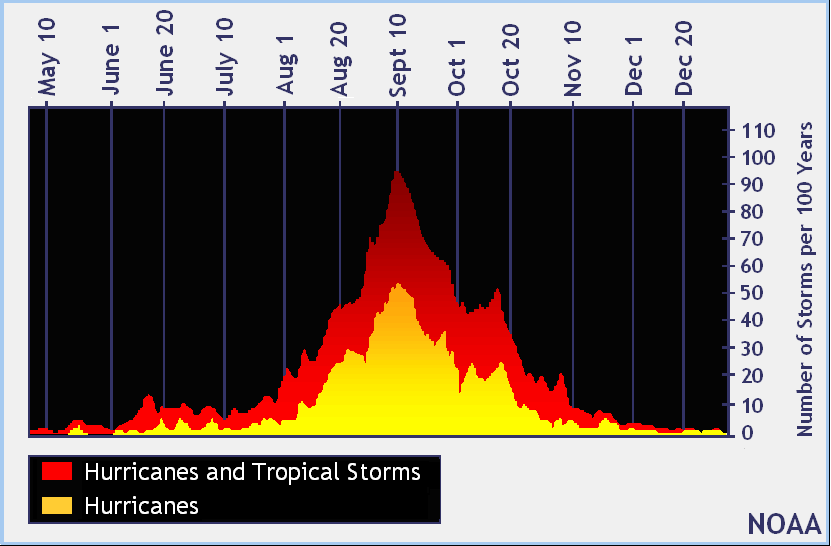
The Atlantic hurricane season begins on June 1, but an equally important date to mark on your calendar is September 1—the start of the most active month for hurricane activity. Since official record keeping of hurricanes began in 1950, over 60% of all Atlantic named storms have developed in the months of August or September.
What is it about late August and September that produces a flurry of tropical cyclones within the Atlantic Ocean?
Generation of Storm Seedlings
One of the reasons why cyclone activity climbs is the hyperactive African Easterly Jet (AEJ). The AEJ is an east-to-west oriented wind, much like the jet stream that flows across the US. As you may remember, temperature contrasts drive weather, including the flow of wind. The AEJ flows across Africa into the tropical Atlantic Ocean, thanks to the contrast in temperature between the dry, hot air over the Sahara Desert and the cooler, humid air over the forested areas of central Africa and the Gulf of Guinea.
Since the flow near the AEJ goes faster than that further away in the surrounding air, what happens is that eddies begin to develop due to these differences in speed. When this happens, you get what's called a "tropical wave"—an unstable kink or wave in the main flow pattern that is visible on satellite as clusters of thunderstorms. By providing the initial energy and spin needed for a hurricane to develop, tropical waves act like "seedlings" of tropical cyclones. The more seedlings the AEJ generates, the more chances there are for tropical cyclone development.
Sea Temperatures Still in Summer Mode
Of course, having a storm seedling is only half of the recipe. A wave won't automatically grow into a tropical storm or hurricane, unless several of the atmosphere's other conditions, including sea surface temperatures (SSTs), are favorable.
While temperatures may be cooling off for us land-dwellers as fall begins, SSTs in the tropics are just reaching their peak. Because water has a higher heat capacity than land, it heats more slowly, which means the waters that have spent all summer absorbing the sun's warmth are just reaching their maximum warmth at summer's end.
Sea surface temperatures must be 82°F or warmer for a tropical cyclone to form and thrive, and in September, temperatures across the tropical Atlantic average 86°F, nearly 5 degrees warmer than this threshold.
Seasonal Peak
When you look at hurricane climatology, you'll see a sharp increase in the number of named storms forming between late August into September. This increase typically continues until September 10-11, which is thought of as the season's peak. "Peak" doesn't necessarily mean multiple storms will form at once or be active across the Atlantic on this particular date, it simply highlights when the bulk of named storms will have occurred by. After this peak date, storm activity typically declines gently, with another five named storms, three hurricanes, and one major hurricane occurring on average by the season's November 30 end.
Most Atlantic Hurricanes at Once
Although the word "peak" doesn't necessarily point to when the greatest number of cyclones will happen at once, there are several occasions when it did.
The record for most hurricanes to ever occur at the same time in the Atlantic basin occurred in September 1998, when as many as four hurricanes—Georges, Ivan, Jeanne, and Karl—simultaneously spun across the Atlantic. As for the most tropical cyclones (storms and hurricanes) to ever exist at one time, a maximum of five occurred on September 10-12, 1971.
Peak Locations
Cyclone activity not only heats up in September but the activity in places where you can expect cyclones to spin up increases, as well. In late summer and early fall, there's generally an increased chance that storms will develop in the Caribbean Sea, along the Eastern Atlantic Seaboard, and in the Gulf of Mexico.
By November, cold fronts and increasing wind shear—two disrupters to tropical development—penetrate into the Gulf of Mexico, Atlantic, and sometimes into the western Caribbean Sea as well, which spells the end of the peak August-October period.
VIDEO: Watch Now: All About Hurricanes (3:07)
https://www.thoughtco.com/september-heart-of-hurricane-season-4079924
Join the InvestorsHub Community
Register for free to join our community of investors and share your ideas. You will also get access to streaming quotes, interactive charts, trades, portfolio, live options flow and more tools.


