 News
News  Market Data
  Discover
Support: 888-992-3836
Copyright © 2023 InvestorsHub Inc.


Hilander
![]()
Register for free to join our community of investors and share your ideas. You will also get access to streaming quotes, interactive charts, trades, portfolio, live options flow and more tools.
Register for free to join our community of investors and share your ideas. You will also get access to streaming quotes, interactive charts, trades, portfolio, live options flow and more tools.
I'll take The Dime!
Not Today - Next Week:
Would love to monitor the board today but can't.

Sorry man, I'm traveling, no time to play today.
Your good at flying solo - keep up the good work!
OK - I asked Mick the question for you.
Request from Dizzydon:
At this point in time, Dizzydon can't join the Berlin Board for discussion.
I'm his courrier pigeon today with a message.
Please post answer's at CHDO board:
http://investorshub.advfn.com/boards/read_msg.asp?message_id=22588565
Posted by: dizzydon
In reply to: Hilander who wrote msg# 35689 Date:9/4/2007 5:04:12 PM
Post #of 35701
I've only got a free subcription Hilander;
when I went to the Berlin Exchange Board I discovered only paid I-HUB subscibers can post on it.
Could you ask Mick if shorting,especially naked shorting,over in Germany could result in the stock going on the SHO Threshold list's here?
Thanks Again
<@@>
[_____]
Have A Nice BIG PAYDAY!
We're on the train and ready to go.
Its just a matter of who wants to average down, anybody?
Just One of the Problems of OTCBB Stocks:
This is one of the problems with trading OTCBB stocks.
Apparently anyone at any time can decide to pirate shares and sell them on the Berlin Exchange.
Its not fair trading and tends to kill the stock price from moving upward.
Unless China Direct can release good news to move the company forward, we are stuck in limbo with no place to go.

Come on baby, lets go!
Recent dialogue on CHDO Board this am:
Mick, you might wanna check out the dialogue going on at the China Direct board:
http://investorshub.advfn.com/boards/read_msg.asp?message_id=22577733
Investors interested and wanna know more about the Berlin Exchanges.
Your the expert and possibly you have some words of wisdom for them.
Check it out at:
Posted by: dizzydon
In reply to: Hilander who wrote msg# 35685 Date:9/4/2007 12:27:18 PM
Post #35686 of 35689
Thanks;
are there really 4 different exchanges in Germany or is there an overlap of some sort that makes it a good deal less significant then if there were?
Ask Mick - He's the Expert:
Mick has done a lot of research in regard to the Berlin Exchange.
He would know better than me due to his recent research findings.
He's a great guy and am sure he would field any of your questions or point you in the right direction.
Then possibly you could report your findings for all to learn from, we would all appreciate your efforts.
http://investorshub.advfn.com/boards/board.asp?board_id=10210
Berlin Stock Exchange = Pirated Shares:
Its never a good sign when a companies shares show up on the Berlin Exchange.
Hopefully, the company knows about it and will hire attorneys to issue a seise & decist order immediately.
Mick's board explains the problem.
Its definitely worth a read.
Then you can decide if you wanna post it here.
Berlin Stock Exchange Board.
Here's a new board recently started by Mick which holds a lot of good info & links:
http://investorshub.advfn.com/boards/board.asp?board_id=10210
This Baby should be turning North SOON!
What's taken soo long?

Where's the news we've been expecting?
I know, patience, patience, patience...
Need More Volume:
Someone's still buying on the cheap.
Sure would like to get some news of any kind.
Good, bad or indifferent, it makes no difference to me.
We need a turn-around to make this ballgame interesting.
Maybe the storms will make a difference in this baby coming alive?
Which Board?
Can you post it here?

I'd love to read it and anything else related to getting us out of the doldrums!
My Pleasure, Looking Forward to Tomorrow, Good night.
Signing Off for Today - Goodbye.
Very Good Public Service:
Congratulations Mick, I gotta hand it to ya, you are providing a very valuable public service to the private investor community.

Now, we can quickly check our stocks to see if they're being illegally traded.
Cheers, To a job well done!!!
You've provided a wealth of useful information.
Now its up to us to follow up on the research to see what you've uncovered.
Thank you for setting this all up!
Best Regards,
Hilander
GREAT NEWS:
We're safe. - No matches came up for SGCR!
As of now, there is no listing on the Berlin Exchange.
I have faith, hope & trust that it will stay that way!!!
Here's where I went to make the click:
http://www.berlinstockmarket.com/

Here's what the search says:
The Berlin Stock Market
http://www.berlinstockmarket.com/quotes.php?symbols=sgcr
Local Berlin time is Thursday, August 30, 2007, 10:16pm - Market opens in 10 hours, 44 minutes
Indicies
DAX 7519.94 80.76 (1.09%)
Dow 13238.73 50.56 (0.38%)
MDAX 10128.42 177.77 (1.79%)
Nasdaq 2565.30 2.14 (0.08%)
TECDAX 903.00 4.00 (0.44%)
S&P 500 1457.64 6.12 (0.42%)
Euro to US Dollar Exchange Rate 1.3625
Quotes
Enter a US stock symbol and receive a quote for the security on both the US and Berlin stock markets.
Symbol(s):
Database of Low Float stocks
The symbol SGCR is not in my database.
The administrator has been notified and this symbol will be added soon if it is actually traded on the Berlin exchange.
Do Not have time right Now:
Mick, don't have time right now to click it.

I'll have to get back to you later, I'm on a long distance phone call.
Then it'll be time for another cuppa coffee.
Don't let me get ahead of you!
Here's the $64,000 Question for the day:
Ref: Question from Spark:
"Hi I see you all over SSWM...was it dilution that brought it down so low? If so do you know the current size of the float? Thanks."
Answer from Hilander:
I KNOW BUGS has been diluted but don't know by how much.
I DO NOT know about the dilution with SSWM?
I'll ask the question at the BUGS message board.
Stop by for the answer:
http://investorshub.advfn.com/boards/board.asp?board_id=3756
The current Outstanding Shares & Float as of today:
Outstanding Shares: 163.738 M
Float: 146.268 M
Does anyone have the OS count previously?
If so we can compare it and see if there has been any dilution.
Anyone who knows the previous OS & Float, please step forward.

Here's a free cup of coffee for the person who has the answer!
OK, thanks, I'll check it out.
Whiskey & Gunpowder:
Clean water is the Earth's most precious resource.

http://www.whiskeyandgunpowder.com/ppc/WaterInvestingReport.html?gclid=CMv0rcv8nY4CFSXCYAodtnc7Rg
And clean water is quietly becoming one of the most critical
resource issues in the world economy...
The global fresh water crisis makes the oil “crisis” look like no problem at all. That’s why the profits you could make in water investments will dwarf the gains made by oil stocks in the past few years…
The Global Water Crises Presents a
Tremendous Opportunity for Investors
In Your Free Report You’ll Discover…
Water Investment #1: The Simplest Way to
Profit From the Entire Global Water Crisis…
With a Single Stock
Water Investment #2: A Water Play Set to Explode From the Coming Government-Mandated Explosion
in Infrastructure Spending
After you sign up, you’ll begin receiving the Whiskey and Gunpowder free eletter, and we’ll send you Your Exclusive Water Investment Brief…
Blue Gold: Two Blockbuster Water Plays
Ready to Burst Wide Open
Despite the recent stunning performance of water stocks, they still have a long way to go. Obviously, the worldwide water problem won’t go away. You can be sure that these water stocks will have a healthy run when the rest of the investing world starts paying attention.
Poor Performance:
OK, let me understand you correctly.
You have not verified if SGCR is being traded in Berlin?
Candlestick Study Material:
Have you seen this?
If not, here's some good reference material on candlesticks.
This is good stuff. Grab a cuppa coffee and read for awhile.
JAPANESE CANDLESTICKS - History:
http://www.candlesticker.com/Default.asp
NEUTRAL REVERSAL PATTERNS - MEDIUM RELIABILITY (Doji found here)
http://www.candlesticker.com/Neutral.asp
BEARISH REVERSAL PATTERNS - HIGH RELIABILITY:
http://www.candlesticker.com/Bearish.asp
BULLISH REVERSAL PATTERNS - HIGH RELIABILITY:
http://www.candlesticker.com/Bullish.asp
These candlestick patterns are posted inside Americanbulls.com (used by day traders)
http://www.americanbulls.com/StockPage.asp?CompanyTicker=SSWM&MarketTicker=OTC&TYP=S
Nice L2 Chart:
Please post the link where you found the L2 chart.
I'd like to use for future reference.
TIA!
Posting on BUGS Board:
Ref: "Maybe we can move our posts to the BUGS Board for the next week".
Great, Lets go for it.
I think posting on the BUGS board's a good idea.
It would give us a chance to learn what they're doing + pick up some additonal knowledge along the way.
In the process we're bound to learn something that would help our trading strategy at SSWM.
Go for it, I'll see you there.

In regard to the share price of SSWM:
Yes I've learned a stock will not rally until its time or it will just fall back down again.
Why?
Because there's not enough momentum to keep it going.
We Just gotta be patient.
When the MM'ers are ready to take this baby up, it'll go and not until. They have to play their little games with shorting and manipulating the stock down until they get there positions set.
I know I'm not big enough or have enough money to influence this market but the MM'ers do, they're the ones in the drivers seat.
Sometimes I have to remind myself, I'm just a little fish trying to catch a ride on top of a whale without getting eaten.
Good Morning Mick - You night Owl:
Very nice board.
I can see you put a lot of time and effort into setting this all up.
Very Good Work Indeed!
Keep It UP, we're just about out of the doldrums.
In September, things should start coming ALIVE.
Question:
Just curious, did you do the click on SGCR at the Berlin Exchange to see if they're being shorted?

Lets Go Greens - Time to Rally!
I'm ready to get across this bridge!

Closing Volume = 117,116 with 0.00% Gain:
The Greens finish up the day with little to no selling pressure from the Reds.
Last Green Buy Order Filled @ CLosing:
That was a Long buyen on the cheap. - Very smart buyer!
Depth/Level II for Sub Surface Waste Management of Delaware Inc.
8/29/2007 5:23 PM
SSWM Last: 0.007 Change: -0.001(-12.50%) Volume: 3.6 m Last Trade: 3:48
Time & Sales
Price Size Exch Time
0.007 1,771,667 shares OBB 15:48:38
Watch Out Shorties:
Here we come!

THE GREENS ARE GATHERING STRENGTH!
Re-Posted at your Service Sir:
Rhino, I posted this for you at SWWM since you should be running outta posts for the day.
When you gonna buy the up-date so you can keep up with the veterans?
http://investorshub.advfn.com/boards/read_msg.asp?message_id=22467136
Re-Post from Hurricane Board:
Posted by: Rhinoman712
In reply to: None Date:8/29/2007 3:35:02 PM
Post #6854 of 6855
http://investorshub.advfn.com/boards/read_msg.asp?message_id=22466586
I GOT THIS BABY LOCKED IN ON MY RADAR!!!

Ready Aim ...
Re-Post from Hurricane Board:
Posted by: Rhinoman712
In reply to: None Date:8/29/2007 3:35:02 PM
Post #6854 of 6855
http://investorshub.advfn.com/boards/read_msg.asp?message_id=22466586
Dr. Jeff Masters' WunderBlog
Last Updated: 2:37 PM GMT on August 29, 2007 — Last Comment: 7:29 PM GMT on August 29, 2007 All Blogs This Blog
Powered by WunderSearch ®
Katrina's 2nd anniversary, and the tropical update
Posted by: JeffMasters, 10:19 AM EDT on August 29, 2007
A tropical wave midway between Africa and the Lesser Antilles (94L) has changed little since yesterday. QuikSCAT data from 4:47am EDT this morning shows a poorly organized system with a weak, elongated circulation. Top winds were 25 knots (29 mph). Visible satellite loops show a limited amount of disorganized thunderstorm activity. Wind shear is a favorable 5-10 knots over 94L, and should not be a problem for it until Friday or Saturday. By then, 94L will be moving through the Lesser Antilles Islands, and may encounter high wind shear if it is far enough north to feel the winds of an upper-level low pressure system that will be just north of Puerto Rico.
The presence of a large, dusty area of dry air surrounding its north side is the main thing holding back 94L. This dry air is being sucked into the circulation and is interfering with the storm's organization. When the dry air encounters a thunderstorm inside 94L, this denser dry air gets incorporated into the thunderstorm's downdraft, accelerating the downdraft, and creating arc-shaped surface cumulus clouds that mark the downdraft's position as it spreads out along the ocean surface (Figure 1). The presence of these arc-shaped surface clouds is usually a good sign that a storm is struggling with dry air and will not intensify significantly for at least the next 12 hours.
Water vapor satellite loops of the region show that 94L has not significantly moistened its environment. As the storm continues further west, it should be able to gradually do so, allowing it more of a chance to get organized. The system should track through the Lesser Antilles Islands on Friday, which is the earliest day I expect it could become a tropical depression. None of the reliable computer models make a believable forecast showing 94L developing into a tropical depression before it reaches the Lesser Antilles. The GFDL develops 94L into a tropical storm once it makes it into the central Caribbean south of the Domincan Republic, and this is a believable forecast, if 94L hangs together and makes it into the central Caribbean. The Hurricane Hunters are on call to investigate 94L on Friday.

Figure 1. Visible satellite image of 94L, show arc-shaped outflow boundaries from thunderstorm downdrafts.
South Carolina low
An area of low pressure has developed a few hundred miles off the South Carolina coast, along an old frontal boundary. This disturbance has been designated "95L" by NHC this morning. QuikSCAT showed a sharp wind shift but no closed circulation around 95L this morning at 6:34am EDT, and measured winds as high as 50 mph. Wind shear is about 15 knots over the disturbance, which is drifting south into a region where wind shear is expected to remain low enough to allow some development this week. I do think 95L will become a tropical depression, and most of the computer models also agree on this. The models disagree substantially on 95L's track, though. Steering currents will be weak in its vicinity, and 95L may spend a number of days wandering erratically. The Hurricane Hunters will investigate 95L Thursday afternoon.
Coast of Africa
The UKMET model is indicating the possible development of a tropical depression by Friday off the coast of Africa. There is a large surge of moisture with at least one strong tropical wave embedded in it coming off the coast of Africa this week, and it would be no surprise to see this wave develop into a tropical depression.
Katrina, two years later
Two years ago today, on August 29, 2005, Hurricane Katrina smashed into the Gulf coast with Category 3 winds and an incredible storm surge up to 27.8 feet high. Wunderblogger Mike Theiss was at ground zero in Gulfport, Mississippi during Katrina, and has posted a blog this morning on his experience, complete with some very compelling photos. His video of the storm surge washing into the hotel he was at is the most amazing storm video I've ever seen.
Margie Kieper's Katrina's Storm Surge feature on our tropical page provides an extraordinarily detailed 16-part examination of each portion of the coast devastated by Katrina. Margie is scheduled to be a guest on the Talking Tropics Internet radio show Thursday night to talk about Katrina's storm surge. Check the listings to see if there are any last minute changes.
![]()
The photo above was taken from Part 8: Lakeshore to Waveland, MS of Katrina's storm surge. An excerpt from the text:
I found an astonishing photo, of the peak of the surge in Waveland, which didn't appear to be faked, but I'm pretty much of a skeptic. The photo had this caption, "Photo taken in Waveland, MS, just North of the Railroad Tracks during Katrina around 9 AM by Judith Bradford." Note that it is being taken from the second floor window of a home, and that the water is close to the roof line of the first floor. There is a man perched on what is left of a home across the street, wearing a tiny life jacket and clutching a neon green pool noodle. There are electric lines running down from a pole to a home from left to right. In the distance on the right is a home with water up to the roof line. It is likely after 9am, as the bulk of the surge came between 9 and 10 am (that is when most of the fatalities occurred along the Mississippi coast), and probably the eye is already overhead, as the water is relatively calm and there appears to be little wind or rain, even though the pine trees are bent from the recent force of the eyewall winds.
The information provided by the Bradfords regarding the surge was very specific. The power went out at around 6:30am at their Waveland home on the morning of the 29th. They were staying in the home for a couple of reasons; first, because the home had not received any water at all from Camille, and, secondly, because both work in the medical field and needed to be available after the storm. At almost exactly 8:30am, water started coming over the railroad track embankment, from the coast, and into their yard.
Their home is 18 inches off the ground, and the first floor has 8-foot ceilings. There is an 18-inch truss between the 1st and 2nd floors, and this is what saved their 2nd floor from being flooded. In a matter of only five to ten minutes the water came up six feet, and quickly filled the first floor after that. Judith said that is why they saved so little from the first floor; they had no time to get anything. She first tried to shut the living room front door, but the force of the water burst the door open. She grabbed a camera and the Bradfords and their children ran upstairs. They marked the high water mark (HWM) on the inner stairwell showing how high the water came ? a little more than six more inches into the truss, which is a total of 10 feet of surge.
They saved two other people besides the man who was floating by on the roof in the photo. He was a chef named Glen, holding a four month old dachshund named Pinky, in the surge. He had lost his other dog and three cockatiels when his mother's home collapsed. The roof wedged against their van, underwater, and stopped, so they were able to save him. Bill Bradford told me when he swam out to rescue that man, that the water was so warm it seemed almost hot. He said the current was nothing like white water, but was a gentle continuous flow.
Because their home is right by the railroad tracks, it is not as high in elevation as I had thought. It is around 17 feet elevation. That is close to the HWM observed in Pass Christian, 27 feet.
With such a good quality HWM, I wondered why their house was not surveyed. Judith Bradford told me that no one from the federal government seemed to realize their house was there. The road leading up to Jeff Davis (they own 6 ½ acres and raise miniature horses, which were drowned in their stables when the surge came) was filled with debris. The teams doing Search and Recovery for bodies didn't even check the house because they didn't know it was there; it was a good thing the family survived!
The water started to go down sometime after 11am, and by noon was about chest high, and by 2pm about waist-deep. The water finally left the house completely by about 4 or 5 pm that evening. She believes the railroad track embankment kept the water from receding faster. "
I'll have an update Thursday morning, unless there's a major change in 94L or 95L. My thoughts and prayers are with all those affected by Hurricane Katrina today. Let us not forget what happened two years ago.
Jeff Masters
You Guessed It!
I'm planning on hitting a home run with SSWM!

Go Baby Go!
Very Interesting ? Indeed:
These are the water & oil stocks I'm betten on.
Their all in the doldrums currently.
So, the prices are still cheap.
THESE ARE THE OIL STOCKS I'M BETTEN ON.

RIGHT NOW, ITS THE REDS AGAINST THE GREENS AND THE GREENS ARE GETTEN READY TO SCORE A FIELD GOAL!
Lastly but not Leastly:
Thats it for today.

Complements of the "Masked Coffee Man" at:
http://investorshub.advfn.com/boards/board.asp?board_id=2398
General Hurricane Watch Data Post #4:
List of Most intense Pacific Hurricanes:
Costliest Eastern Pacific Hurricanes:
Cost refers to total estimated property damage.
Rank Hurricane Season Cost (2007 USD)
1 Pauline 1997 $9.6 billion
2 Iniki 1992 $2.6 billion
3 Iwa 1982 $664 million
4 Kathleen 1976 $144–577 million
5 Norma 1981 $303 million
Category 5 Pacific Hurricanes:
Name ... Season
Patsy 1959
"Mexico" 1959
Ava 1973
Emilia 1994
Gilma 1994
John 1994
Guillermo 1997
Linda 1997
Elida 2002
Hernan 2002
Kenna 2002
Loke 2006
Full Article:
http://en.wikipedia.org/wiki/List_of_notable_tropical_cyclones
General Hurricane Watch Data Post #3:
List of Most intense Atlantic Hurricanes:
Most intense Atlantic hurricanes
Intensity is measured solely by central pressure
Rank Hurricane Season Min. pressure
1 Wilma 2005 882 mbar (hPa)
2 Gilbert 1988 888 mbar (hPa)
3 "Labor Day" 1935 892 mbar (hPa)
4 Rita 2005 895 mbar (hPa)
5 Allen 1980 899 mbar (hPa)
6 Katrina 2005 902 mbar (hPa)
7 Camille 1969 905 mbar (hPa)
Mitch 1998 905 mbar (hPa)
9 Dean 2007 906 mbar (hPa)
10 Ivan 2004 910 mbar (hPa
Costliest U.S. Atlantic hurricanes
Cost refers to total estimated property damage.
Rank Hurricane Season Cost (2005 USD)
1 Katrina 2005 $81.2 billion
2 Andrew 1992 $44.9 billion
3 Wilma 2005 $20.6 billion
4 Charley 2004 $15.4 billion
5 Ivan 2004 $14.6 billion
Deadliest Atlantic hurricanes
Rank Hurricane Season Fatalities
1 "Great Hurricane" 1780 22,000
2 Mitch 1998 11,000 – 18,000
3 "Galveston" 1900 8,000 – 12,000
4 Fifi 1974 8,000 – 10,000
5 "Dominican Republic" 1930 2,000 – 8,000
6 Flora 1963 7,186 – 8,000
7 "Pointe-a-Pitre" 1776 6,000+
8 "Newfoundland 1775 4,000 – 4,163
9 "Okeechobee" 1928 4,075+
10 "San Ciriaco" 1899 3,433+
Most intense landfalling U.S. hurricanes
Intensity is measured solely by central pressure
Rank Hurricane Season Landfall pressure
1 "Labor Day" 1935 892 mbar (hPa)
2 Camille 1969 909 mbar (hPa)
3 Katrina 2005 920 mbar (hPa)
4 Andrew 1992 922 mbar (hPa)
5 "Indianola" 1886 925 mbar (hPa)
6 "Florida Keys" 1919 927 mbar (hPa)
7 "Okeechobee" 1928 929 mbar (hPa)
8 Donna 1960 930 mbar (hPa)
9 "New Orleans" 1915 931 mbar (hPa)
Carla 1961 931 mbar (hPa)
Full Article:
http://en.wikipedia.org/wiki/List_of_notable_tropical_cyclones
General Hurricane Watch Data Post #2:
List of Huricane's since 1851 to 2005:
List of US Hurricanes:
http://www.aoml.noaa.gov/hrd/hurdat/ushurrlist.htm
Chronological List of All Hurricanes which Affected the Continental
United States: 1851-2005.(Updated from Jarrell et al. 1992 and reflecting official
HURDAT reanalysis changes through 1914. Note that from 1915 through 1979, no
official wind speed estimates are currently available. Document revised in May 2006)
Year Month States Affected Highest Saffir- Central Max. Name
and Category by Simpson U.S. Pressure Winds
States Category
1851 Jun TX, C1 1 977 mb 80 kt -----
1851 Aug FL, NW3; GA, 1 3 960 100 “Great Middle Florida”
1852 Aug FL, SW1 1 977 80 -----
1852 Aug AL, 3; MS, 3; LA, 2; FL, NW1 3 961 100 “Great Mobile”
1852 Sep FL, SW1 1 985 70 -----
1852 Oct FL, NW2; GA, 1 2 969 90 “Middle Florida”
1853 Oct * GA, 1 1 965 70 -----
1854 Jun TX, S1 1 985 70 -----
1854 Sep GA, 3; SC, 2; FL, NE1 3 950 100 “Great Carolina”
1854 Sep TX, C2 2 969 90 “Matagorda”
1855 Sep LA, 3; MS, 3 3 950 110 “Middle Gulf Shore”
1856 Aug LA, 4 4 934 130 “Last Island”
1856 Aug FL, NW2; AL, 1; GA, 1 2 969 90 “Southeastern States”
1857 Sep & NC, 1 1 961 80 -----
1858 Sep NY, 1; CT, 1; RI, 1; MA, 1 1 976 80 “New England”
1859 Sep AL, 1; FL, NW1 1 985 70 -----
1860 Aug LA, 3; MS, 3; AL, 2 3 950 110 -----
1860 Sep LA, 2; MS, 2; AL, 1 2 969 90 -----
1860 Oct LA, 2 2 969 90 -----
1861 Aug * FL, SW1 1 970 70 “Key West”
1861 Sep NC, 1 1 985 70 “Equinoctial”
1861 Nov NC, 1 1 985 70 “Expedition”
1865 Sep LA, 2; TX, N1 2 969 90 “Sabine River-Lake Calcasieu”
1865 Oct FL, SW2; FL, SE1 2 969 90 -----
1866 Jul TX, C2 2 969 90 -----
1867 Jun SC, 1 1 985 70 -----
1867 Oct LA, 2; TX, S1, N1; FL, NW1 2 969 90 “Galveston”
1869 Aug TX, C2 2 969 90 “Lower Texas Coast”
1869 Sep LA, 1 1 985 70 -----
1869 Sep RI, 3; MA, 3; NY, 1; CT, 1 3 963 100 “Eastern New England”
1869 Oct & ME, 2; MA, 1 2 965 90 “Saxby’s Gale”
1870 Jul AL, 1 1 985 70 “Mobile”
1870 Oct * FL, SW1, SE1 1 970 70 “Twin Key West (I)”
1870 Oct FL, SW1 1 977 80 “Twin Key West (II)”
1871 Aug FL, SE3, NE1, NW1 3 955 100 -----
1871 Aug FL, SE2, NE1 2 965 90 -----
1871 Sep FL, NW1 1 985 70 -----
1873 Sep FL, NW1 1 985 70 -----
1873 Oct FL, SW3, SE2, NE1 3 959 100 -----
1874 Sep FL, NW1; SC, 1; NC, 1 1 985 70 -----
1875 Sep TX, C3, S2 3 960 100 -----
1876 Sep NC, 1; VA, 1 1 980 80 -----
1876 Oct FL, SW2, SE1 2 973 90 -----
1877 Sep LA, 1; FL, NW1 1 985 70 -----
1877 Oct FL, NW3; GA, 1 3 960 100 -----
1878 Sep FL, NW2, SW2, NE1; SC, 1; GA, 1 2 970 90 -----
1878 Oct NC, 2; VA, 1; MD, 1; DE, 1; 2 963 90 -----
NJ, 1; PA, 1
1879 Aug NC, 3; VA, 2 3 971 100 -----
1879 Aug TX, N2; LA, 2 2 964 90 -----
1879 Sep LA, 3 3 950 110 -----
1880 Aug # TX, S3 3 931 110 -----
1880 Aug FL, SE2, NE1, NW1 2 972 90 -----
1880 Sep NC, 1 1 987 70 -----
1880 Oct FL, NW1 1 985 70 -----
1881 Aug GA, 2; SC, 1 2 970 90 -----
1881 Sep NC, 2 2 975 90 -----
1882 Sep FL, NW3; AL, 1 3 949 100 -----
1882 Sep LA, 2; TX, N1 2 969 90 -----
1882 Oct FL, NW1 1 985 70 -----
1883 Sep NC, 2; SC, 1 2 965 90 -----
1885 Aug SC, 3; NC, 2; GA, 1; FL, NE1 3 953 100 -----
1886 Jun TX, N2; LA, 2 2 973 85 -----
1886 Jun FL, NW2; GA, 1 2 973 85 -----
1886 Jun FL, NW2 2 973 85 -----
1886 Jul FL, NW1 1 985 70 -----
1886 Aug TX, C4 4 925 135 “Indianola”
1886 Sep # TX, S1, C1 1 973 80 -----
1886 Oct LA, 3; TX, N2 3 955 105 -----
1887 Jul FL, NW1 1 981 75 -----
1887 Aug * NC, 1 1 946 65 -----
1887 Sep TX, S2 2 973 85 -----
1887 Oct LA, 1 1 981 75 -----
1888 Jun TX, C1 1 985 70 -----
1888 Aug FL, SE3, SW1; LA2 3 945 110 -----
1888 Sep & MA, TS TS 985 55 -----
1888 Oct FL, NW2, NE1 2 970 95 -----
1889 Sep LA, 1 1 985 70 -----
1891 Jul TX, C1, N1 1 977 80 -----
1891 Aug FL, SE1 1 985 70 -----
1893 Aug NY, 1 1 986 75 “Midnight Storm”
1893 Aug GA, 3; SC, 3; NC, 1; FL, NE1 3 954 100 “Sea Islands”
1893 Sep LA, 2 2 973 85 -----
1893 Oct LA, 4; MS, 2; AL, 2 4 948 115 “Chenier Caminanda”
1893 Oct SC, 3; NC, 2; VA, 1 3 955 105 -----
1894 Sep FL, SW2, NE1; SC, 1; VA, 1 2 975 90 -----
1894 Oct FL, NW3; GA, 1; NY, 1; RI, 1 3 955 105 -----
1895 Aug # TX, S1 1 973 65 -----
1896 Jul FL, NW2 2 973 85 -----
1896 Sep RI, 1; MA, 1 1 985 70 -----
1896 Sep FL, NW3, NE3; GA, 2; SC, 1; 3 960 110 -----
NC, 1; VA, 1
1897 Sep LA, 1; TX, N1 1 981 75 -----
1898 Aug FL, NW1 1 985 70 -----
1898 Aug GA, 1; SC, 1 1 980 75 -----
1898 Oct GA, 4; FL, NE2 4 938 115 -----
1899 Aug FL, NW2 2 979 85 -----
1899 Aug NC, 3 3 945 105 -----
1899 Oct NC, 2; SC, 2 2 955 95 -----
1900 Sep TX, N4 4 936 125 “Galveston”
1901 Jul NC, 1 1 983 70 -----
1901 Aug LA, 1; MS, 1; AL, 1 1 973 80 -----
1903 Sep FL, SE1, NW1 1 976 80 -----
1903 Sep NJ, 1; DE, 1 1 990 70 -----
1904 Sep SC, 1 1 985 70 -----
1904 Oct FL, SE1 1 985 70 -----
1906 Jun FL, SW1, SE1 1 979 75 -----
1906 Sep SC, 1; NC, 1 1 977 80 -----
1906 Sep MS, 2; AL, 2; FL, NW2; LA, 1 2 958 95 -----
1906 Oct FL, SW3, SE3 3 953 105 -----
1908 May & NC, TS TS 989 55 -----
1908 Jul NC, 1 1 985 70 -----
1909 Jun TX, S2 2 972 85 -----
1909 Jul TX, N3 3 959 100 “Velasco”
1909 Aug # TX, S1 1 955 65 -----
1909 Sep LA, 3; MS, 2 3 952 105 “Grand Isle”
1909 Oct FL, SW3, SE3 3 957 100 -----
1910 Sep TX, S2 2 965 95 -----
1910 Oct FL, SW2 2 955 95 -----
1911 Aug FL, NW1; AL,1 1 985 70 -----
1911 Aug SC, 2; GA, 1 2 972 85 -----
1912 Sep AL, 1; FL, NW1 1 988 65 -----
1912 Oct TX, S2 2 973 85 -----
1913 Jun TX, S1 1 988 65 -----
1913 Sep NC, 1 1 976 75 -----
1913 Oct SC, 1 1 989 65 -----
1915 Aug TX, N4 4 945 ----- “Galveston”
1915 Sep FL, NW1 1 988 ----- -----
1915 Sep LA, 4 4 931 ----- “New Orleans”
1916 Jul MS, 3; AL, 3 3 948 ----- -----
1916 Jul MA, 1 1 ----- ----- -----
1916 Jul SC, 1 1 980 ----- -----
1916 Aug TX, S3 3 948 ----- -----
1916 Oct AL, 2; FL, NW2 2 972 ----- -----
1916 Nov FL, SW1 1 ----- ----- -----
1917 Sep FL, NW3 3 958 ----- -----
1918 Aug LA, 3 3 955 ----- -----
1919 Sep FL, SW4; TX, S4 4 927 ----- -----
1920 Sep LA, 2 2 975 ----- -----
1920 Sep NC, 1 1 ----- ----- -----
1921 Jun TX, C2 2 979 ----- -----
1921 Oct FL, SW3, NE2 3 952 ----- “Tampa Bay”
1923 Oct LA, 1 1 985 ----- -----
1924 Sep FL, NW1 1 985 ----- -----
1924 Oct FL, SW1 1 980 ----- -----
1925 No-De FL, SW1 1 ----- ----- -----
1926 Jul FL, NE2 2 967 ----- -----
1926 Aug LA, 3 3 955 ----- -----
1926 Sep FL, SE4, SW3, NW3; AL, 3 4 935 ----- “Great Miami”
1928 Aug FL, SE2 2 ----- ----- -----
1928 Sep FL, SE4, NE2; GA, 1; SC, 1 4 929 ----- “Lake Okeechobee”
1929 Jun TX, C1 1 982 ----- -----
1929 Sep FL, SE3, NW2 3 948 ----- -----
1932 Aug TX, N4 4 941 ----- “Freeport”
1932 Sep AL, 1 1 979 ----- -----
1933 Jl-Au # TX, S2; FL, SE1 2 975 ----- -----
1933 Aug NC, 2; VA, 2 2 971 ----- -----
1933 Sep TX, S3 3 949 ----- -----
1933 Sep FL, SE3 3 948 ----- -----
1933 Sep NC, 3 3 957 ----- -----
1934 Jun LA, 3 3 962 ----- -----
1934 Jul TX, S2 2 975 ----- -----
1935 Sep FL, SW5, NW2 5 892 ----- “Labor Day”
1935 Nov FL, SE2 2 973 ----- -----
1936 Jun TX, S1 1 987 ----- -----
1936 Jul FL, NW3 3 964 ----- -----
1936 Sep NC, 2 2 ----- ----- -----
1938 Aug LA, 1 1 985 ----- -----
1938 Sep NY, 3; CT, 3; RI, 3; MA, 3 3 946 ----- “New England”
1939 Aug FL, SE1, NW1 1 985 ----- -----
1940 Aug TX, N2; LA, 2 2 972 ----- -----
1940 Aug GA, 2; SC, 2 2 970 ----- -----
1941 Sep TX, N3 3 958 ----- -----
1941 Oct FL, SE2, SW2, NW2 2 975 ----- -----
1942 Aug TX, N1 1 992 ----- -----
1942 Aug TX, C3 3 950 ----- -----
1943 Jul TX, N2 2 969 ----- -----
1944 Aug NC, 1 1 990 ----- -----
1944 Sep NC, 3; VA, 3; NY, 3; CT, 3; 3 947 ----- -----
RI, 3; MA, 2
1944 Oct FL, SW3, NE2 3 962 ----- -----
1945 Jun FL, NW1 1 985 ----- -----
1945 Aug TX, C2 2 967 ----- -----
1945 Sep FL, SE3 3 951 ----- -----
1946 Oct FL, SW1 1 980 ----- -----
1947 Aug TX, N1 1 992 ----- -----
1947 Sep FL, SE4, SW2; MS, 3; LA, 3 4 940 ----- -----
1947 Oct GA, 2; SC, 2; FL, SE1 2 974 ----- -----
1948 Sep LA, 1 1 987 ----- -----
1948 Sep FL, SW3, SE2 3 963 ----- -----
1948 Oct FL, SE2 2 975 ----- -----
1949 Aug * NC, 1 1 980 ----- -----
1949 Aug FL, SE3 3 954 ----- -----
1949 Oct TX, N2 2 972 ----- -----
1950 Aug AL, 1 1 980 ----- Baker
1950 Sep FL, NW3 3 958 ----- Easy
1950 Oct FL, SE3 3 955 ----- King
1952 Aug SC, 1 1 985 ----- Able
1953 Aug NC, 1 1 987 ----- Barbara
1953 Sep ME, 1 1 ----- ----- Carol
1953 Sep FL, NW1 1 985 ----- Florence
1954 Aug NY, 3; CT, 3; RI, 3; NC, 2 3 960 ----- Carol
1954 Sep MA, 3; ME, 1 3 954 ----- Edna
1954 Oct SC, 4; NC, 4; MD, 2 4 938 ----- Hazel
1955 Aug NC, 3; VA, 1 3 962 ----- Connie
1955 Aug NC, 1 1 987 ----- Diane
1955 Sep NC, 3 3 960 ----- Ione
1956 Sep LA, 2; FL, NW1 2 975 ----- Flossy
1957 Jun TX, N4; LA, 4 4 945 ----- Audrey
1959 Jul SC, 1 1 993 ----- Cindy
1959 Jul TX, N1 1 984 ----- Debra
1959 Sep SC, 3 3 950 ----- Gracie
1960 Sep FL, SW4; NC, 3; NY, 3; FL, NE2; 4 930 ----- Donna
CT, 2; RI, 2; MA, 1; NH, 1; ME, 1
1960 Sep MS, 1 1 981 ----- Ethel
1961 Sep TX, C4 4 931 ----- Carla
1963 Sep TX, N1 1 996 ----- Cindy
1964 Aug FL, SE2 2 968 ----- Cleo
1964 Sep FL, NE2 2 966 ----- Dora
1964 Oct LA, 3 3 950 ----- Hilda
1964 Oct FL, SW2, SE2 2 974 ----- Isbell
1965 Sep FL, SE3; LA, 3 3 948 ----- Betsy
1966 Jun FL, NW2 2 982 ----- Alma
1966 Oct FL, SW1 1 983 ----- Inez
1967 Sep TX, S3 3 950 ----- Beulah
1968 Oct FL, NW2, NE1 2 977 ----- Gladys
1969 Aug LA, 5; MS, 5 5 909 ----- Camille
1969 Sep ME, 1 1 980 ----- Gerda
1970 Aug TX, S3 3 945 ----- Celia
1971 Sep LA, 2 2 978 ----- Edith
1971 Sep TX, C1 1 979 ----- Fern
1971 Sep NC, 1 1 995 ----- Ginger
1972 Jun FL, NW1; NY, 1; CT, 1 1 980 ----- Agnes
1974 Sep LA, 3 3 952 ----- Carmen
1975 Sep FL, NW3 3 955 ----- Eloise
1976 Aug NY, 1 1 980 ----- Belle
1977 Sep LA, 1 1 995 ----- Babe
1979 Jul LA, 1 1 986 ----- Bob
1979 Sep FL, SE2, NE2; GA, 2; SC, 2 2 970 ----- David
1979 Sep AL, 3; MS, 3 3 946 ----- Frederic
1980 Aug TX, S3 3 945 100 Allen
1983 Aug TX, N3 3 962 100 Alicia
1984 Sep * NC, 3 3 949 100 Diana
1985 Jul SC, 1 1 1002 65 Bob
1985 Aug LA, 1 1 987 80 Danny
1985 Sep AL, 3; MS, 3; FL, NW3 3 959 100 Elena
1985 Sep NC, 3; NY,3; CT,2; NH,2; ME,1 3 942 90 Gloria
1985 Oct LA, 1 1 971 75 Juan
1985 Nov FL, NW2 2 967 85 Kate
1986 Jun TX, N1 1 990 75 Bonnie
1986 Aug NC, 1 1 990 65 Charley
1987 Oct FL, SW1 1 993 65 Floyd
1988 Sep LA, 1 1 984 70 Florence
1989 Aug TX, N1 1 986 70 Chantal
1989 Sep SC, 4 4 934 120 Hugo
1989 Oct TX, N1 1 983 75 Jerry
1991 Aug RI, 2; MA, 2; NY, 2; CT, 2 2 962 90 Bob
1992 Aug FL, SE5, SW4; LA, 3 5 922 145 Andrew
1993 Aug * NC, 3 3 960 100 Emily
1995 Aug FL, NW2, SE1 2 973 85 Erin
1995 Oct FL, NW3 3 942 100 Opal
1996 Jul NC, 2 2 974 90 Bertha
1996 Sep NC, 3 3 954 100 Fran
1997 Jul LA, 1; AL, 1 1 984 70 Danny
1998 Aug NC, 2 2 964 95 Bonnie
1998 Sep FL, NW1 1 987 70 Earl
1998 Sep FL, SW2; MS, 2 2 964 90 Georges
1999 Aug TX, S3 3 951 100 Bret
1999 Sep NC, 2 2 956 90 Floyd
1999 Oct FL, SW1 1 987 70 Irene
2002 Oct LA, 1 1 963 80 Lili
2003 Jul TX, C1 1 979 80 Claudette
2003 Sep NC, 2; VA, 1 2 957 90 Isabel
2004 Aug * NC, 1 1 972 70 Alex
2004 Aug FL, SW4, SE1, NE1; SC,1; NC,1 4 941 130 Charley
2004 Aug SC, 1 1 985 65 Gaston
2004 Sep FL, SE2, SW1 2 960 90 Frances
2004 Sep AL, 3; FL, NW3 3 946 105 Ivan
2004 Sep FL, SE3, SW1, NW1 3 950 105 Jeanne
2005 Jul LA, 1 1 991 65 Cindy
2005 Jul FL, NW3 3 946 105 Dennis
2005 Aug FL, SE1; LA, 3; MS, 3; AL, 1 3 920 110 Katrina
2005 Sep * NC, 1 1 982 65 Ophelia
2005 Sep FL, SW1; LA, 3; TX, N2 3 937 100 Rita
2005 Oct FL, SW3; FL, SE2 3 950 105 Wilma
Notes:
States Affected and Category by States Affected: The impact of the
hurricane on individual U.S. states based upon the Saffir-Simpson Scale
(through the estimate of the maximum sustained surface winds at each state).
(TX S-South Texas, TX C-Central Texas, TX N-North Texas, LA-Louisiana,
MS-Mississippi, AL-Alabama, FL NW-Northwest Florida, FL SW-Southwest
Florida, FL SE-Southeast Florida, FL NE-Northeast Florida, GA-Georgia,
SC-South Carolina, NC-North Carolina, VA-Virginia, MD-Maryland, DE-Delaware,
NJ-New Jersey, NY-New York, PA-Pennsylvania, CT-Connecticut, RI-Rhode Island,
MA-Massachusetts, NH-New Hampshire, ME-Maine. In Texas, south refers to the
area from the Mexican border to Corpus Christi; central spans from north of
Corpus Christi to Matagorda Bay and north refers to the region from north of
Matagorda Bay to the Louisiana border. In Florida, the north-south dividing
line is from Cape Canaveral [28.45N] to Tarpon Springs [28.17N]. The
dividing line between west-east Florida goes from 82.69W at the north Florida
border with Georgia, to Lake Okeechobee and due south along longitude 80.85W.)
Highest U.S. Saffir-Simpson Category: The highest Saffir-Simpson Hurricane
Scale impact in the United States based upon estimated maximum sustained
surface winds produced at the coast.
Central Pressure: The observed (or analyzed from peripheral pressure
measurements) central pressure of the hurricane at landfall.
Maximum Winds: Estimated maximum sustained (1-min) surface (10 m) winds to
occur along the U. S. coast. Winds are estimated to the nearest 10 kt for the
period of 1851 to 1885 and to the nearest 5 kt for the period of 1886 to date.
(1 kt = 1.15 mph.)
* - Indicates that the hurricane center did not make a U.S. landfall (or
substantially weakened before making landfall), but did produce the indicated
hurricane force winds over land. In this case, central pressure is given for
the hurricane's point of closest approach.
& - Indicates that the hurricane center did make a direct landfall, but that
the strongest winds likely remained offshore. Thus the winds indicated here
are lower than in HURDAT.
# - Indicates that the hurricane made landfall over Mexico, but also caused
sustained hurricane force surface winds in Texas. The strongest winds at
landfall impacted Mexico, while the weaker maximum sustained winds indicated
here were conditions estimated to occur in Texas. Indicated central pressure
given is that at Mexican landfall.
Additional Note: Because of the sparseness of towns and cities before 1900 in
some coastal locations along the United States, the above list is not complete
for all states. Before the Gulf of Mexico and Atlantic coasts became settled,
hurricanes may have been underestimated in their intensity or missed completely
for small-sized systems (i.e., 2004’s Hurricane Charley). The following list
provides estimated dates when accurate tropical cyclone records began for
specified regions of the United States based upon U.S Census reports and other
historical analyses. Years in parenthesis indicate possible starting dates for
reliable records before the 1850s that may be available with additional research:
Texas-south – 1880, Texas-central – 1851, Texas-north – 1860, Louisiana – 1880,
Mississippi – 1851, Alabama < 1851 (1830), Florida-northwest – 1880,
Florida-southwest – 1900, Florida-southeast – 1900, Florida-northeast – 1880,
Georgia < 1851 (1800), South Carolina < 1851 (1760), North Carolina < 1851 (1760),
Virginia < 1851 (1700), Maryland < 1851 (1760), Delaware < 1851 (1700), New
Jersey < 1851 (1760), New York < 1851 (1700), Connecticut < 1851 (1660), Rhode
Island < 1851 (1760), Massachusetts < 1851 (1660), New Hampshire < 1851 (1660),
and Maine < 1851 (1790).
General Hurricane Watch Data Post #1:
I found some research this morning I thought this board would enjoy.
Here we Go:
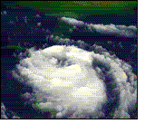
Satellite animation of Hurricane Georges, which struck the Mississippi Gulf coast in 1998.
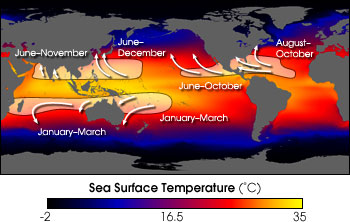
When does hurricane season start?
The Atlantic hurricane season is from June 1 to November 30, but most hurricanes occur during the fall months. The Eastern Pacific hurricane season is from May 15 to November 30. (Above is a graphic that shows you when hurricanes are most active across parts of the world.)
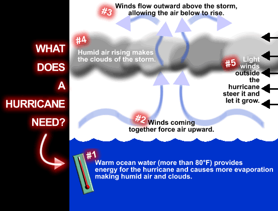
How do hurricanes form?
Hurricanes only form over really warm ocean water of 80°F or warmer. The atmosphere (the air) must cool off very quickly the higher you go. Also, the wind must be blowing in the same direction and at the same speed to force air upward from the ocean surface. Winds flow outward above the storm allowing the air below to rise. Hurricanes typically form between 5 to 15 degrees latitude north and south of the equator. The Coriolis Force is needed to create the spin in the hurricane and it becomes too weak near the equator, so hurricanes can never form there.
(Graphic Credit: UCAR)
BTW, that was a great buy @ 0.009!
I wish I was so lucky.
I've owned SSWM for one year+.
I look at it this way, I will pay long term capital gains tax in lieu of short term.
There's more than one way to skin this cat.


