Register for free to join our community of investors and share your ideas. You will also get access to streaming quotes, interactive charts, trades, portfolio, live options flow and more tools.
Dangerous Rapidly Intensifying Landfalling Hurricanes Like Michael and Harvey May Grow More Common
Dr. Jeff Masters · October 12, 2018, 4:33 PM EDT

https://www.wunderground.com/cat6/Dangerous-Rapidly-Intensifying-Landfalling-Hurricanes-Michael-and-Harvey-May-Grow-More-Common
Above: Homes and businesses along US 98 are left in devastation by Hurricane Michael on October 12, 2018 in Mexico Beach, Florida. Image credit: Mark Wallheiser/Getty Images.
As Hurricane Michael sped northwards on October 9 towards a catastrophic landfall on Florida’s Panhandle, the mighty hurricane put on an phenomenal display of rapid intensification. Michael’s winds increased by 45 mph in the final 24 hours before landfall, taking it from a Category 2 hurricane with 110 mph winds to an extremely dangerous high-end Category 4 storm with 155 mph winds. It was a disturbing déjà vu of what had happened just one year earlier. On August 25, 2017, Hurricane Harvey rapidly intensified by 40 mph in the 24 hours before landfall, from a Category 1 storm with 90 mph winds to a Category 4 storm with 130 mph winds.
Harvey flood

Figure 1. Hurricane Harvey hit Texas as a Category 4 hurricane with 130 mph winds on August 25, 2017, then stalled over Houston for three days, dumping over 50” of rain. Harvey caused $125 billion in damage, and killed 89 people. Above: People walk down a flooded street as they evacuate their homes after the area was inundated with flooding from Hurricane Harvey on August 28, 2017 in Houston, Texas. Image credit: Joe Raedle/Getty Images.
Extreme rapid intensification rates expected to become more common
In a 2016 paper, “Will Global Warming Make Hurricane Forecasting More Difficult?” (available here from the Bulletin of the American Meteorological Society), MIT hurricane scientist Kerry Emanuel explained that not only will global warming make the strongest hurricanes stronger, it will also increase how fast they intensify. Troublingly, intensification rates don’t increase linearly as the intensity of a storm increases--they increase by the square power of the intensity. Thus, we can expect future hurricanes to intensify at unprecedented rates, and the ones that happen to perform their rapid intensification just before landfall will be extremely dangerous.
Dr. Emanuel used a computer model that generated a set of 22,000 landfalling U.S. hurricanes during the recent climate period of 1979 - 2005, then compared their intensification rates to a similar set of hurricanes generated in the climate expected at the end of the 21st century. For the future climate, he assumed a business-as-usual approach to climate change—the path we are currently on. The analysis found that the odds of a hurricane intensifying by 70 mph or greater in the 24 hours just before landfall were about once every 100 years in the climate of the late 20th century. But in the climate of the year 2100, these odds increased to once every 5 - 10 years. What’s more, 24-hour pre-landfall intensifications of 115 mph or more—which were essentially nonexistent in the late 20th Century climate—occurred as often as once every 100 years by the year 2100. The major metropolitan areas most at risk for extreme intensification rates just before landfall included Houston, New Orleans, Tampa/St. Petersburg, and Miami.
In an email, Dr. Emanuel said: “My own work shows that rates of intensification increase more rapidly than intensity itself as the climate warms, so that rapidly intensifying storms like Michael may be expected to become more common." Moreover, he added, "My work on Hurricane Harvey and a few other heavy rain-producing hurricanes such as Florence, together with much previous work by others on the subject, strongly suggests that hurricane-related flooding will increase as the climate continues to warm.”
A dangerous scenario: a rapidly intensifying hurricane making landfall
Hurricanes like Michael and Harvey that rapidly intensify just before landfall are among the most dangerous storms there are, since they can catch forecasters and populations off guard, risking inadequate evacuation efforts and large casualties. Lack of warning and rapid intensification just before landfall were key reasons for the high death toll of the most intense hurricane on record to hit the U.S--the 1935 Labor Day hurricane in the Florida Keys. That storm intensified by 80 mph in the 24 hours before landfall, topping out as a Category 5 hurricane with 185 mph winds and an 892 mb pressure at landfall. At least 408 people were killed, making it the eighth deadliest hurricane in U.S. history. Another rapidly intensifying hurricane at landfall, Hurricane Audrey of June 1957, was the seventh deadliest U.S. hurricane, killing at least 416. Audrey’s winds increased by 35 mph in the 24 hours before landfall near the Texas/Louisiana border, when it was a Category 3 hurricane with 125 mph winds. Lack of warning and an unexpectedly intense landfall were cited as key reasons for the high death toll.
Of course, nowadays we have satellites and radar and regular hurricane hunter flights and advanced computer forecast models, so the danger of another Audrey or 1935 Labor Day hurricane taking us by surprise is lower. Or is it? All of that fancy technology didn’t help much for 2007’s Hurricane Humberto, which hit Texas as a Category 1 storm with 90 mph winds. Humberto had the most rapid increase in intensity in the 24 hours before landfall of any Atlantic hurricane since 1950: 65 mph. A mere 18 hours before landfall, the National Hurricane Center (NHC) predicted a landfall intensity of just 45 mph, increasing that estimate to 65 mph in a forecast issued 6 hours later. It’s fortunate that Humberto was not a stronger system, or the lack of warning could have led to serious loss of life.
Historical records show that since 1950, the greatest 24-hour intensification rates prior to a U.S. landfall were:
Humberto, 2007 (65 mph increase)
King 1950 (60 mph increase)
Eloise 1975 (60 mph increase)
Danny 1997 (50 mph increase)
Michael 2018 (45 mph increase)
Harvey 2017 (40 mph increase)
Cindy 2005 (40 mph increase)

BREAKING Hurricane Michael Destroys Homes Florida Aftermath Drone Raw Footage October 11 2018 News
u2bheavenbound
Published on Oct 11, 2018
ex....
HAARP Ring Storm Center Only, Hurricane Michael!!!!
The Slade Published on Oct 11, 2018
HURRICANE MICHAEL: A Geoengineered Superstorm Targeting Tallahassee and
Florida Panhandle—Why!
Lucid Dreamer
Published on Oct 11, 2018
911 "Open Your Eyes" Hurricane Michael Physicist Admits Government Weather Control on CBS News
Hurricane Michael Discussion: 10:20 PM ET Oct 8, 2018
hurricanetrack Published on Oct 8, 2018
I am in Florida now getting ready for the field mission to cover hurricane
Michael. Before I get some much needed sleep, here are a few thoughts on
Michael...
HURRICANE MICHAEL HEADED STRAIGHT TOWARDS GULF COAST XIII
James Munder
USA TODAY Published on Oct 8, 2018
There's A "Big Wave" Coming And They're Silent About It..(2018-2019)
145,418 views
THAT IS IMPOSSIBLE
Published on Oct 3, 2018
Mysterious Cosmic Rays Shooting Out Of Antarctica Could Shatter Standard Physics Model ???
The Real MLordandGod
Published on Oct 4, 2018
7 Lighting & Thunder Storms last night came through~ one right after another ~ 12 to 18 minutes apart > high winds > some damage in some counties
Thanks Bob
Major Hurricane ROSA, high-impact event for the U.S.
https://www.theweathernetwork.com/news/articles/major-hurricane-rosa-tropical-storm-national-hurricane-center-california-arizona-canada-ontario-impact-flooding-eastern-pacific-season/113184/
God Bless America
45 this last Sunday of October 2018 @ 7:50am
You've had enough rain already. Feeling blessed here!
Florence Rain arrived @ 12 noon Today @ the foot of Mt Nittany
over looking PSU
over 6's so far this month ~ 56 hours of rain
Still raining since Saturday 10am ~ Flood warning out
Thanks for sharing
Cal Fire Pilot Shortage
blancolirio
Published on Sep 6, 2018
Raining ~ working on our 1st inch for Sept.
Rain last night & this am and afternoon
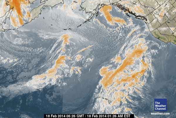
Jumping ahead three weeks to February 18, we see a storm system coming
right from Hawaii and tracking straight as an arrow toward California
and Oregon on what is called the 'Pineapple Express'
Sub Tropical storm route.
bottom lines;
As we predicted, the only significant precipitation to hit the West
Coast this winter will be from storms formed over generally
radiation-free waters in the area of the Hawaiian Islands.

https://rense.com/general96/pacstorms.html
Well said mr40; Very interesting, they should be able o put an end to
hurricanes on the gulf and east coasts too.
ex....
How The Pacific Storms Of
2013-2014 Were Trashed
2-18-14
https://rense.com/general96/pacstorms.html
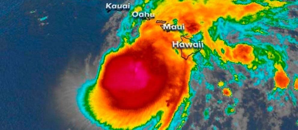
Watch Hurricane Lane Be Destroyed By HAARP-Like EMF
Just Before It Was To Hit The US Military Bases On Oahu - Photos
By Jeff Rense

Proof Of Total Weather Control By The US Military - ? -
https://rense.com/general96/H/poof-of-total-weather-control-by-the-us-military.htm
https://rense.com/
Scientist Who Designed HAARP Confirms EVERYTHING / WEATHERTEC -
This Is Devastating The Caribbean And Nothing Can Stop It?
According to National Weather Service @ Penn State, the total rainfall this summer came to 20.35 inches, beating the old record of 19.83 inches back in 2003
ILLUMINATI NWO MASS GEO ENGINEERING - IRREFUTABLE AGENDA OF BIOLOGICAL & CLIMATE WARFARE
Raining Cats & Dogs again > Flood warding's
Total Rain was 8.4 inches @ the foot of mountain over looking PSU for the month of July 2018
CARR FIRE Northern California Wildfire 2018 July - Pray For Redding
Fishing is good for ones health!
Good Fishing
back here most of time too @
Spring Creek
Penns Creek
Bald Eagle
and few more places
J Carter lives to come here to fish
Haven't seen rain here.
High 80's low 90's fishing weather.
over 4" so far this month & rain coming today
HAARP is activating the Pacific Ring of Fire
Rothschild owns Weather Control Media and knows HAARP #2
We been blessed with good May and now June doing well. Rain has been light with good temps. Watching that garden I need a good harvest this year.


WEATHER LINKS & DISCUSSION
AWESOME VIDEO:
NEW >>>
INCREDIBLE TORNADO VIDEO!! >>>>>>
http://www.youtube.com/watch?v=DNL7ASvl4k4&eurl=http%3A%2F%2Ftornadovideos%2Enet%2F
http://www.ultimatechase.com/Hail_Video.htm
THE PERFECT STORM:
http://www.ncdc.noaa.gov/oa/satellite/satelliteseye/cyclones/pfctstorm91/pfctstorm.html
WEATHER SITES:
http://moe.met.fsu.edu/cyclonephase/ukm/fcst/archive/06082800/7.html
http://www.weather.com/
http://www.nws.noaa.gov/
http://www.stormtrack.org/
http://home.accuweather.com/index.asp?partner=accuweather
http://www.noaa.gov/
http://www.theweathernetwork.com/ (CANADA)
http://www.wunderground.com/
http://www.esdim.noaa.gov/weather_page.html
http://cirrus.sprl.umich.edu/wxnet/
http://www.intellicast.com/
http://members.aol.com/Accustiver/wxworld_sites.html
http://earthquake.usgs.gov/recenteqsww/Quakes/quakes_all.html
http://www.almanac.com/
MY FAVORITE SITES:
http://www.globalsecurity.org/eye/pic-2005.htm
http://vortex.plymouth.edu/usheat.gif
http://www.wunderground.com/satellite/vis/1k/US.html
http://www.srh.noaa.gov/ridge/ffc.shtml
http://www.iww.is/art/shs/pages/thumbs.html
http://www.skeetobiteweather.com/index.asp
http://www.noaanews.noaa.gov/stories2005/s2540.htm

**This picture was taken up the street from me >>>

[B]DOWNTOWN ATLANTA TORNADO >>>[/B]

SUPER STORM of 1993


| Volume | |
| Day Range: | |
| Bid Price | |
| Ask Price | |
| Last Trade Time: |
