


Monday, November 18, 2013 8:01:02 PM
Antarctica iceberg separates from Pine Island Glacier and is moving to open waters
The bad news continues for our planets air conditioner. Iceberg B-31, estimated to be 35 by 20 km or the size of Virginia Beach or Singapore, has cracked and is moving away from the coast.
“In mid-October 2011, NASA scientists working in Antarctica discovered a massive crack across the Pine Island Glacier, a major ice stream that drains the West Antarctic Ice Sheet. Extending for 19 miles (30 kilometers), the crack was 260 feet (80 meters) wide and 195 feet (60 meters) deep.”
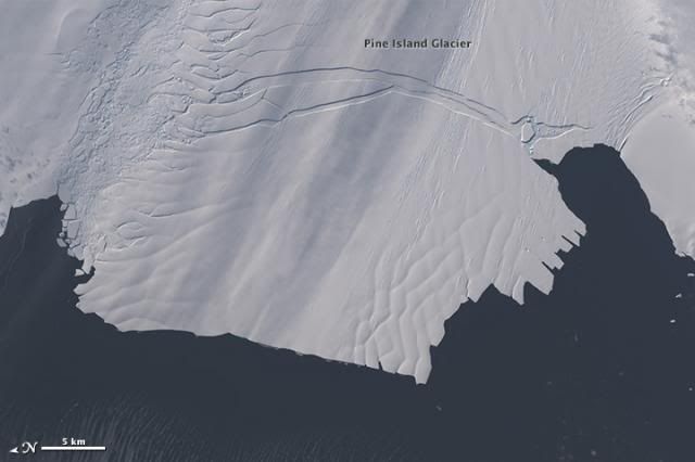
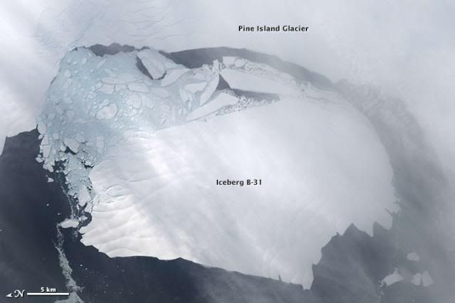
Scientists first detected a rift in the glacier in October 2011. By July 2013, infrared and radar images showed that the crack had cut completely across the ice shelf to the southwestern edge. New images now show that Iceberg B-31 is finally moving away from the coast, with open water between the iceberg and the edge of Pine Island Glacier.
Pine Island Glacier 2013: Nov. 10
This MODIS image taken by NASA’s Aqua satellite on Nov. 10, 2013, shows an iceberg that was part of the Pine Island Glacier and is now separating from the Antarctica continent. What appears to be a connection point on the top left portion of the iceberg is actually ice debris floating in the water.
The original rift that formed the iceberg was first observed in October 2011 but as the disconnection was not complete, the “birth” of the iceberg had not yet happened. It is believed the physical separation took place on or about July 10, 2013, however the iceberg persisted in the region, adjacent to the front of the glacier.
Image credit: NASA
According to The Watchers:
http://thewatchers.adorraeli.com/2013/11/18/major-iceberg-cracks-off-pine-island-glacier/
Scientists have been studying Pine Island Glacier closely because there is evidence that warmer seawater below the shelf will cause the ice grounding line to retreat and the glacier to thin and speed up. The shelf of Pine Island Glacier has been moving forward at roughly 4 kilometers per year. Pine Island Glacier is the longest and fastest flowing glacier in the Antarctic, with vast icebergs being calved from ice shelf every 6-10 years. Previous notable events occurred in 2007 and 2001.
NASA reports:
“It is hard to predict with certainty where and when these things will drift,” said NASA glaciologist Kelly Brunt. “Icebergs move pretty slowly, and watching this iceberg will be a waiting game.”http://visibleearth.nasa.gov/view.php?id=82392
The shelf of Pine Island Glacier has been moving forward at roughly 4 kilometers per year, so the calving of this iceberg is not necessarily a surprise, noted Tom Wagner, NASA’s cryosphere program manager. Such events happen about every five or six years, though Iceberg B-31 is about 50 percent larger than previous ones in this area. Scientists have been studying Pine Island Glacier closely because there is evidence that warmer seawater below the shelf will cause the ice grounding line to retreat and the glacier to thin and speed up.
If Pine Island Bay clears of ice by the annual sea ice minimum in February–March, then Iceberg B-31 could move out into the Southern Ocean. (Click here for a wider view of Antarctica and the sea ice blocking the path.) Once it leaves the bay, the iceberg is likely to get caught up in the flow of the “coastal counter current”—which flows counterclockwise around Antarctica—or the “circumpolar current,” which is larger, wider, and flows clockwise.
Which way it goes depends on the vertical shape and depth of the iceberg, according to NASA scientist emeritus Robert Bindschadler. “Where it is going depends on the deeper currents into which its keel extends,” he said. Researchers have found that larger icebergs with deeper keels tend to drift with the deeper, cyclonic circumpolar current, while sea ice and smaller bergs with shallower keels tend to drift with the coastal counter current.
“If you ever throw a stick into a mountain stream, you would see an erratic flow as it spins, accelerates, and decelerates,” Bindschadler said. “I imagine a similarly variable current field working on the iceberg's keel. This iceberg is like a very, very big stick.”
Pine Island Glacier study or PIG is as an active and ongoing project of NASA. http://pigiceshelf.nasa.gov/
This project’s official title is "Ocean-Ice Interaction in the Amundsen Sea: the Keystone to Ice-Sheet Stability". A real mouthful, but it captures the essence of what we intend to do, where we will do it and why we feel it is important to do it. Various other measurements have captured the West Antarctic ice sheet changing very rapidly in the region where it flows into the Amundsen Sea, one of the sectors of the Southern Ocean. The spatial pattern strongly suggests that the cause of this change is weaker ice shelves, the floating apron of ice that fringe the perimeter of the ice sheet. Our hypothesis is that warm water is melting the undersides of these ice shelves decreasing the "back pressure" from the ice shelves to help hold the ice sheet. Less backpressure means the ice sheet can flow faster. Faster flow-smaller ice sheet-higher sea levels-slow motion coastal flooding worldwide.
There is even more depressing news from the West Antarctica ice shelf, which I will diary soon. Meanwhile, the climate change enablers continue to play their fiddles while our planet burns.
http://www.dailykos.com/story/2013/11/18/1256561/-Antarctica-iceberg-separates-from-Pine-Island-Glacier-and-is-moving-to-open-waters
The bad news continues for our planets air conditioner. Iceberg B-31, estimated to be 35 by 20 km or the size of Virginia Beach or Singapore, has cracked and is moving away from the coast.
“In mid-October 2011, NASA scientists working in Antarctica discovered a massive crack across the Pine Island Glacier, a major ice stream that drains the West Antarctic Ice Sheet. Extending for 19 miles (30 kilometers), the crack was 260 feet (80 meters) wide and 195 feet (60 meters) deep.”

Scientists first detected a rift in the glacier in October 2011. By July 2013, infrared and radar images showed that the crack had cut completely across the ice shelf to the southwestern edge. New images now show that Iceberg B-31 is finally moving away from the coast, with open water between the iceberg and the edge of Pine Island Glacier.

Pine Island Glacier 2013: Nov. 10
This MODIS image taken by NASA’s Aqua satellite on Nov. 10, 2013, shows an iceberg that was part of the Pine Island Glacier and is now separating from the Antarctica continent. What appears to be a connection point on the top left portion of the iceberg is actually ice debris floating in the water.
The original rift that formed the iceberg was first observed in October 2011 but as the disconnection was not complete, the “birth” of the iceberg had not yet happened. It is believed the physical separation took place on or about July 10, 2013, however the iceberg persisted in the region, adjacent to the front of the glacier.
Image credit: NASA
According to The Watchers:
http://thewatchers.adorraeli.com/2013/11/18/major-iceberg-cracks-off-pine-island-glacier/
Scientists have been studying Pine Island Glacier closely because there is evidence that warmer seawater below the shelf will cause the ice grounding line to retreat and the glacier to thin and speed up. The shelf of Pine Island Glacier has been moving forward at roughly 4 kilometers per year. Pine Island Glacier is the longest and fastest flowing glacier in the Antarctic, with vast icebergs being calved from ice shelf every 6-10 years. Previous notable events occurred in 2007 and 2001.
NASA reports:
“It is hard to predict with certainty where and when these things will drift,” said NASA glaciologist Kelly Brunt. “Icebergs move pretty slowly, and watching this iceberg will be a waiting game.”http://visibleearth.nasa.gov/view.php?id=82392
The shelf of Pine Island Glacier has been moving forward at roughly 4 kilometers per year, so the calving of this iceberg is not necessarily a surprise, noted Tom Wagner, NASA’s cryosphere program manager. Such events happen about every five or six years, though Iceberg B-31 is about 50 percent larger than previous ones in this area. Scientists have been studying Pine Island Glacier closely because there is evidence that warmer seawater below the shelf will cause the ice grounding line to retreat and the glacier to thin and speed up.
If Pine Island Bay clears of ice by the annual sea ice minimum in February–March, then Iceberg B-31 could move out into the Southern Ocean. (Click here for a wider view of Antarctica and the sea ice blocking the path.) Once it leaves the bay, the iceberg is likely to get caught up in the flow of the “coastal counter current”—which flows counterclockwise around Antarctica—or the “circumpolar current,” which is larger, wider, and flows clockwise.
Which way it goes depends on the vertical shape and depth of the iceberg, according to NASA scientist emeritus Robert Bindschadler. “Where it is going depends on the deeper currents into which its keel extends,” he said. Researchers have found that larger icebergs with deeper keels tend to drift with the deeper, cyclonic circumpolar current, while sea ice and smaller bergs with shallower keels tend to drift with the coastal counter current.
“If you ever throw a stick into a mountain stream, you would see an erratic flow as it spins, accelerates, and decelerates,” Bindschadler said. “I imagine a similarly variable current field working on the iceberg's keel. This iceberg is like a very, very big stick.”
Pine Island Glacier study or PIG is as an active and ongoing project of NASA. http://pigiceshelf.nasa.gov/
This project’s official title is "Ocean-Ice Interaction in the Amundsen Sea: the Keystone to Ice-Sheet Stability". A real mouthful, but it captures the essence of what we intend to do, where we will do it and why we feel it is important to do it. Various other measurements have captured the West Antarctic ice sheet changing very rapidly in the region where it flows into the Amundsen Sea, one of the sectors of the Southern Ocean. The spatial pattern strongly suggests that the cause of this change is weaker ice shelves, the floating apron of ice that fringe the perimeter of the ice sheet. Our hypothesis is that warm water is melting the undersides of these ice shelves decreasing the "back pressure" from the ice shelves to help hold the ice sheet. Less backpressure means the ice sheet can flow faster. Faster flow-smaller ice sheet-higher sea levels-slow motion coastal flooding worldwide.
There is even more depressing news from the West Antarctica ice shelf, which I will diary soon. Meanwhile, the climate change enablers continue to play their fiddles while our planet burns.
http://www.dailykos.com/story/2013/11/18/1256561/-Antarctica-iceberg-separates-from-Pine-Island-Glacier-and-is-moving-to-open-waters
Join the InvestorsHub Community
Register for free to join our community of investors and share your ideas. You will also get access to streaming quotes, interactive charts, trades, portfolio, live options flow and more tools.

