


Wednesday, December 07, 2011 12:34:43 AM
Boffins: Japan was hit by 'double-wave' tsunami
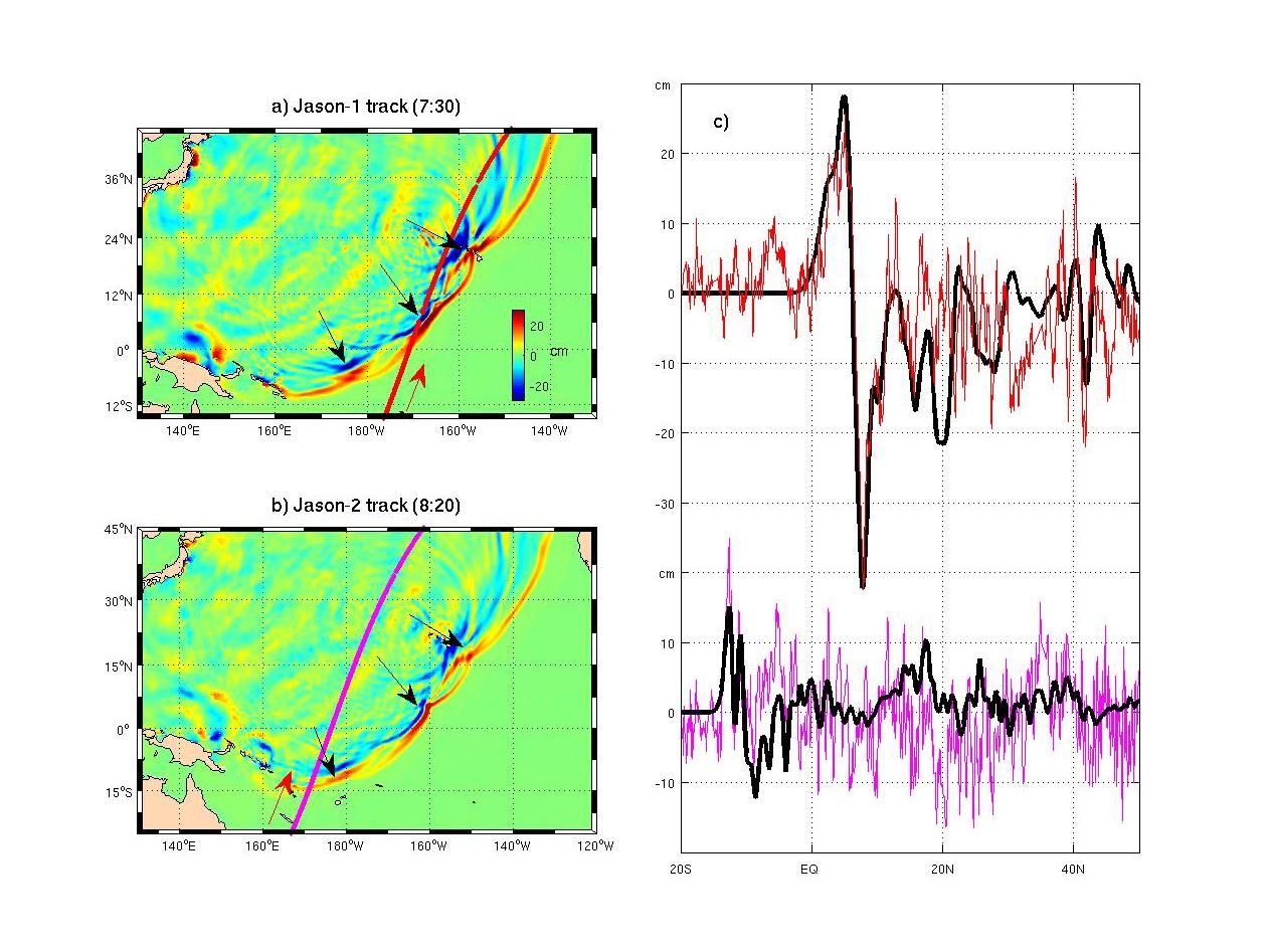
Merging tsunami data from two satellites.
Credit: NASA/JPL-Caltech/Ohio State University
Two became one
By Brid-Aine Parnell
Posted in Environment, 6th December 2011 10:22 GMT
Boffins from NASA and Ohio State University have discovered that the tsunami that hit Japan in March 2011 was a so-called ‘merging tsunami’.
The idea of a merging tsunami, where two or more wave fronts join to form a single wave capable of travelling long distances, has long been hypothesised, but never before confirmed.
NASA and European radar satellites captured at least two wave fronts on the day of the Japanese tsunami, which merged to form a single double-high wave far out at sea that could travel to the coast without losing power.
The two fronts were pushed together by ocean ridges and undersea mountain chains near the tsunami’s origin.
The data gathered could help scientists to improve tsunami forecasts.
"It was a one in 10 million chance that we were able to observe this double wave with satellites," principal investigator Y Tony Song said.
"Researchers have suspected for decades that such 'merging tsunamis' might have been responsible for the 1960 Chilean tsunami that killed about 200 people in Japan and Hawaii, but nobody had definitively observed a merging tsunami until now," he added.
"It was like looking for a ghost. A NASA-French Space Agency satellite altimeter happened to be in the right place at the right time to capture the double wave and verify its existence."
The trouble with tsunami forecasts now is that while the underwater earthquake that is the origin of the event can be pinpointed, the waves themselves often seem to go off in random directions, causing massive destruction in some places but leaving nearby areas unharmed.
The researchers think that ridges and underwater mountains can deflect parts of the initial tsunami wave to form a number of wave fronts.
Current hazard maps that try to predict where tsunamis will hit only take into consideration sea-floor topography near shorelines, but this research suggests scientists might be able to create maps that also take into account ridges and mountains far from shore.
"Tools based on this research could help officials forecast the potential for tsunami jets to merge," Song said. "This, in turn, could lead to more accurate coastal tsunami hazard maps to protect communities and critical infrastructure."
© Copyright 2011 The register
http://www.theregister.co.uk/2011/12/06/merging_tsunami_japan_nasa/ [comments at http://forums.theregister.co.uk/forum/1/2011/12/06/merging_tsunami_japan_nasa/ ]
===
NASA Finds 'Merging Tsunami' Doubled Japan Destruction
RELEASE : 11-405
Dec. 5, 2011
WASHINGTON -- NASA and Ohio State University researchers have discovered the major tsunami generated by the March 2011 Tohoku-Oki quake centered off northeastern Japan was a long-hypothesized "merging tsunami." The tsunami doubled in intensity over rugged ocean ridges, amplifying its destructive power at landfall.
Data from NASA and European radar satellites captured at least two wave fronts that day. The fronts merged to form a single, double-high wave far out at sea. This wave was capable of traveling long distances without losing power. Ocean ridges and undersea mountain chains pushed the waves together along certain directions from the tsunami's origin.
The discovery helps explain how tsunamis can cross ocean basins to cause massive destruction at some locations while leaving others unscathed. The data raise hope that scientists may be able to improve tsunami forecasts.
Research scientist Y. Tony Song of NASA's Jet Propulsion Laboratory in Pasadena, Calif., and professor C.K. Shum of The Ohio State University discussed the data and simulations that enabled them to piece the story together at a media briefing Monday, Dec. 5, at the American Geophysical Union meeting in San Francisco.
"It was a one in 10 million chance that we were able to observe this double wave with satellites," Song said. He is the principal investigator in the NASA-funded study.
"Researchers have suspected for decades that such 'merging tsunamis' might have been responsible for the 1960 Chilean tsunami that killed about 200 people in Japan and Hawaii, but nobody had definitively observed a merging tsunami until now,” Song said. It was like looking for a ghost. A NASA-French Space Agency satellite altimeter happened to be in the right place at the right time to capture the double wave and verify its existence."
The NASA-Centre National d'Etudes Spaciales Jason-1 satellite passed over the tsunami on March 11, as did two other satellites -- the NASA-European Jason-2 and the European Space Agency's EnviSAT. All three carry radar altimeters, which measure sea level changes to an accuracy of a few centimeters. Each satellite crossed the tsunami at a different location, measuring the wave fronts as they occurred. Jason-1 launched 10 years ago this week on Dec. 7, 2001.
"We can use what we learned to make better forecasts of tsunami danger in specific coastal regions anywhere in the world, depending on the location and the mechanism of an undersea quake," Shum said.
The researchers think ridges and undersea mountain chains on the ocean floor deflected parts of the initial tsunami wave away from each other to form independent jets shooting off in different directions, each with its own wave front.
The sea floor topography nudges tsunami waves in varying directions and can make its destruction appear random. For that reason, hazard maps that try to predict where tsunamis will strike rely on sub-sea topography. Previously, these maps considered only topography near a particular shoreline. This study suggests scientists may be able to create maps that take into account all undersea topography, even sub-sea ridges and mountains far from shore.
Song and his team were able to verify the satellite data through model simulations based on independent data, including GPS data from Japan and buoy data from the National Oceanic and Atmospheric Administration's Deep-ocean Assessment and Reporting of Tsunamis program.
"Tools based on this research could help officials forecast the potential for tsunami jets to merge," Song said. "This, in turn, could lead to more accurate coastal tsunami hazard maps to protect communities and critical infrastructure."
For more information about presentations at the American Geophysical Union meeting, visit:
http://www.nasa.gov/agu
Steve Cole
Headquarters, Washington
202-358-0918
stephen.e.cole@nasa.gov
Alan Buis
Jet Propulsion Laboratory, Pasadena, Calif.
818-354-0474
alan.buis@jpl.nasa.gov
http://www.nasa.gov/home/hqnews/2011/dec/HQ_11-405_AGU_Tsunami.html
===
Tsunami distorted perception of danger in Japan
Wed 2011/12/07 09:40 JST
The excessive media exposure of the devastating tsunami that struck Japan in March had an unexpected effect. It distorted the perception Japanese have over what is dangerous and what not when it comes to this kind of disasters, making future prevention more difficult, according to a Japanese professor.
Surveys conducted before and after the March disaster showed how perception shifted among Japanese. When asked “What height of a tsunami would you consider dangerous?” about 70 percent of the respondents of a survey conducted before the March tsunami answered “less than 3 meters”, which is the correct answer.
“A 2-meter-high tsunami can completely destroy your house," said [ http://www.livescience.com/17311-japan-tsunami-danger-misperception-agu.html ] Satoko Oki, an assistant professor at the Earthquake Research Institute, University of Tokyo.
The same question was asked in April in a similar survey, but only 45 percent of the respondents answered correctly.
"So the damage lowered the risk assessment, it did not teach a lesson, but instead, it made the Japanese people more vulnerable than before," Oki said.
Because Japanese kept hearing the high numbers indicating the height of the waves over and over again, they started to evaluate the risks posed by tsunamis against those numbers, she explained. To avoid that people associate a smaller height with less danger, Oki recommended that public reports, including press reports, should present the real danger of small tsunamis, and not only the values registered in March.
Copyright 2011 The Tokyo Times
http://www.tokyotimes.co.jp/post/en/2788/Tsunami+distorted+perception+of+danger+in+Japan.html [no comments yet]
===
Japanese People Less Likely to Evacuate During Future Tsunamis

Tsunami flooding the Sendai Airport in Japan.
Samuel Morse/USAF
[full-sized at http://www.af.mil/shared/media/photodb/photos/110313-F-NW653-528.jpg ]
By Adam Mann December 5, 2011 | 5:09 pm
Disasters are supposed to teach people valuable lessons. But new research shows that following the Tohoku earthquake and subsequent tsunami [ http://www.wired.com/wiredscience/2011/03/japan-earthquake-and-tsunami-update-stunning-videos-and-images/ ] on March 11, 2011, Japanese residents have become less likely to evacuate during a dangerous event.
“A gigantic tsunami did not teach a lesson to the public, leaving people more vulnerable than before,” said Satoko Oki of the University of Tokyo’s Earthquake Research Institute [ http://www.eri.u-tokyo.ac.jp/eng/ ] who presented the findings Dec. 5 at the 2011 American Geophysical Union meeting [ http://sites.agu.org/fallmeeting/ ].
The magnitude 9.0 Tohoku earthquake and tsunami — the largest in Japanese history –- were responsible for more than 15,000 deaths and an estimated $210 billion in property damage.
After the 2010 Chilean earthquake, almost exactly one year before the Tohoku disaster, Oki asked Japanese residents a set of questions related to tsunami preparedness. At the time, roughly 70 percent correctly identified that a 10-foot tsunami is a hazard and 60 percent said they would evacuate in the event of one that tall. Even 1.5 feet of swiftly moving water can carry a person off and drown them, and waves only 6.5 feet high can wash away or destroy wooden houses.
But when the same questions were asked again one month after the Tohoku disaster, the numbers had nearly halved. Only 45 percent of respondents knew that a 10-foot tsunami was hazardous and only 31 percent said they would evacuate if they heard a warning that one was coming. People mostly misidentified a 16-foot tsunami as the point at which to evacuate. Such public perception could become dangerous in the case of future earthquakes and tsunamis.
Oki speculated that the reason for the strange result has to do with a psychological effect called the anchoring heuristic [ http://en.wikipedia.org/wiki/Anchoring ]. “Laypersons are highly inclined to make a judgment based on previous information given to them,” she said.
The effect holds even if the information is unrelated. The size of the number seems to be the important factor. For example, if people are first told that 1,100 people die every year from electrocution, and then asked to estimate the total causalities from floods they will provide a lower answer than people who are first told that 10,000 people are killed in car accidents each year. The higher number becomes an “anchor point,” prompting higher estimates.
With a month of Japanese headlines over and over exclaiming at the record-breaking 130-foot tsunami, the public’s approximations of dangerous tsunami heights inched upward. The solution, Oki said, is to include proper information alongside the enormous tsunami figures. News reports could save future lives if they added one phrase: a 6.5-foot tsunami could wash away your house.
Wired.com © 2011 Condé Nast Digital
http://www.wired.com/wiredscience/2011/12/tsunami-wrong-ideas/ [with comments]

Greensburg, KS - 5/4/07
"Eternal vigilance is the price of Liberty."
from John Philpot Curran, Speech
upon the Right of Election, 1790
F6
Join the InvestorsHub Community
Register for free to join our community of investors and share your ideas. You will also get access to streaming quotes, interactive charts, trades, portfolio, live options flow and more tools.

