 News
News  Market Data
  Discover
Support: 888-992-3836
Copyright © 2023 InvestorsHub Inc.


Register for free to join our community of investors and share your ideas. You will also get access to streaming quotes, interactive charts, trades, portfolio, live options flow and more tools.
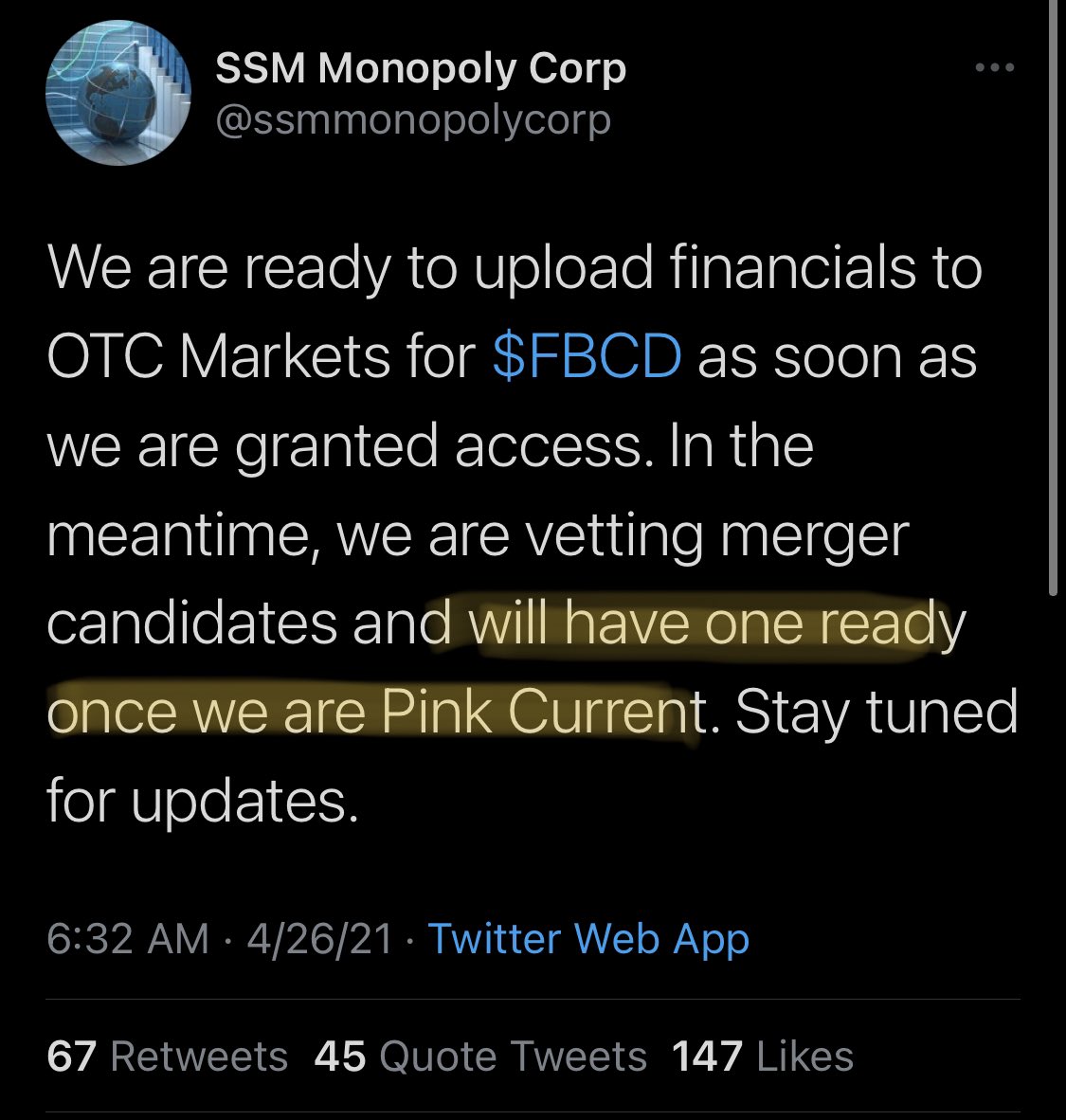
FBCD Now Pink Current - Reinstated - Now_Merger_Ready!
https://www.otcmarkets.com/stock/FBCD/disclosure
Custodian said they would have a merger company ready to go once Pink Current... I think we hear something this week/soon!
also $AWGI $ILIM $INCT $ACCR $AABB & POSSIBLE COMEBACK $ARCS
$ARCS
Trend Table & Recent EOD Signals
https://otcbb.swingtradebot.com/equities/ARCS:OTC
ADX Long Term Intermediate Term Short Term
Strong Up Down Down
Date Alert Name Type % Chg
Jan 29 Narrow Range Bar Range Contraction 0.00%
Jan 29 NR7 Range Contraction 0.00%
Jan 29 Wide Bands Range Expansion 0.00%
Jan 28 20 DMA Resistance Bearish 5.56%
Jan 28 Spinning Top Other 5.56%
Jan 28 Narrow Range Bar Range Contraction 5.56%
Jan 28 Wide Bands Range Expansion 5.56%
Jan 27 Fell Below 20 DMA Bearish 5.56%
Jan 27 1,2,3 Pullback Bullish Bullish Swing Setup 5.56%
Jan 27 Narrow Range Bar Range Contraction 5.56%
everything is greenland north Technical Analysis for DRGV - Dragon Capital Group Corp
https://otcbb.swingtradebot.com/equities/DRGV:OTC
$DRGV What do you think? Is see the screener rating is a B. I have been picking up shares based on the owner of the ticker. I am interested to see what happens with Quanleep going forward. Thanks for your help!
$AWGI Very Strong Up Up Up
Date Alert Name Type % Chg
Jan 29 Spinning Top Other 0.00%
Jan 29 Calm After Storm Range Contraction 0.00%
Jan 29 Wide Bands Range Expansion 0.00%
Jan 28 180 Bullish Setup Bullish Swing Setup -5.97%
Jan 28 Pocket Pivot Bullish Swing Setup -5.97%
Jan 28 Calm After Storm Range Contraction -5.97%
Jan 28 Upper Bollinger Band Walk Strength -5.97%
Jan 28 Wide Bands Range Expansion -5.97%
Jan 27 Wide Range Bar Range Expansion 8.62%
Jan 27 Upper Bollinger Band Walk Strength 8.62%
was this a reinstatment after it was revoked?
$AAWC Reinstated in Jan... Seems to be getting ready here... Filings could drop anytime now...
$ARVY Sizzling Multi-Day Runner! Brand New Reinstatement Play!
Delawre SOS Filings Just Out!
Harry Haining Zhang just took control and is who Just paid 15yrs Taxes ($53,698) and reinstated AVRY...
The Delaware SOS was called to confirm that there had been a change of control and was told that
Haining Zhang Filed Reinstatement, paid taxes and filed annual list...
$ADIA Easy Multi-Bagger From These Levels! New_Custodian_Play!
- Filings Out Last Thursday Afternoon
- Targets = .05/.10/.25
- Word just spreading on this ground floor custodianship
- Can Move Fast = Only 13.8m float...
- CEO with MJ Connections
- Same Custodian that just did $OCSM .005 to a high of.024 so far.
- Court Record:
https://www.clarkcountycourts.us/Portal/Case/CaseDetail?eid=qaTxcrW8UxKptMhrmbs8bQ2&tabIndex=3
- ADIA Ihub DD Page:
https://investorshub.advfn.com/Adia-Nutrition-Inc-ADIA-17566/
DEEL $042 NOW SUDDEN FILINGS OUT >>>R/M? https://www.otcmarkets.com/stock/DEEL/disclosure
1 WEEK AGO >>>>
+ DEEL J. ARCARO Shell REINSTATED 08/09/2019 08/12/2019 + J. Acaro Shell since 3 weeks!! R/M next?
UNRG Major MMJ Players Taking over...
https://investorshub.advfn.com/boards/read_msg.aspx?message_id=150849133
Milo1 Member Level Saturday, 08/31/19 06:38:08 PM
Re: zeekhoe post# 325 0
Post # of 329
We do know a few very important details here:
1) A 23M NOL is worth 7M+ to the right company straight off the top. Currently with the PPS @ .023 we have a market cap of only $713,000 (ridiculously low). We should have a CONSERVATIVE MINIMUM valuation of 7M here.
2) They are moving a profitable company into this shell to take advantage of the the NOL
3) Douglas DiSanti is a hedge fund operator in the MJ world (just like the owner of DCGD)
4) The soon to be custodian of this shell (there is no one to contest as the previous owner has passed away) does not do this as a business (like Lazar) where they gain a custodianship to sell to someone else at a hit and miss rate of success to the investor. This is a targeted shell acquired for a specific purpose related to the MJ hedge fund, or profitable alternative MJ business.
This is about as sure as it gets in the OTC world. Follow the DD, it leads to a possible incredible payday, and don't be surprised if you see Justin Costello drop in here and purchase a few shares as well. It is right up his alley of investment.
GL all, we are early, and we are golden!
Have a good three day weekend!
+ DEEL 0275 J. Arcaro Shell REINSTATED 08/09/2019 08/12/2019 + J. Acaro Shell since 3 weeks!! R/M next? DEEL next SOLI type mover?
20190091283 Certificate of Reinstatement
https://esos.nv.gov/EntitySearch/BusinessFilingHistroyOnline
Link of filing https://www.clarkcountycourts.us/Portal/Case/CaseDetail?eid=4xB2x1bzJKNVgM6xsjnR2Q2&tabIndex=3
WSGF Must see: Now Official Lazar Shell.. Newest & Cheapest...60mil OS at .01~ With this SS we can .25+ Quickly
https://www.clarkcountycourts.us/Portal/Case/CaseDetail?eid=hpaiRI2tB9zgw60keQgjGQ2&tabIndex=3
https://www.otcmarkets.com/stock/WSGF/security
WSGF Security Details
Share Structure
Market Cap Market Cap
450,119
08/21/2019
Authorized Shares
Not Available
Outstanding Shares
60,015,872
11/14/2011
Restricted
Not Available
Unrestricted
Not Available
Held at DTC
Not Available
Float
Not Available
Par Value
0.00
THANK YOU EVER SO MUCH---DEEL
++ DEEL $0135 Reinstate!! + J. Acaro Shell since 2 weeks and now a Reinstated filing. J. Acaro is the ultimate 15-12G Shell to R/M maker on OTC-market with a unbelievable successful history. Seems DEEL the next one if i read this News. R/M filings now anytime possible I think. Around 50m O/S is ultra low. Maybe next CYPE mover. $0.1-$0.5 possible? Think monsta breakout coming.
DEEL REINSTATED 08/09/2019 08/12/2019 20190091283 Certificate of Reinstatement
https://esos.nv.gov/EntitySearch/BusinessFilingHistroyOnline
Link of filing https://www.clarkcountycourts.us/Portal/Case/CaseDetail?eid=4xB2x1bzJKNVgM6xsjnR2Q2&tabIndex=3
OTCMarkets/SEC filings will start to hit shortly
$WSGF ACTIVE! WOW this one is going FAST!
Court date set for August 14th. Os of 60m, float is probably micro
Is a Reinstatement when a company goes thru a SEC Suspension, then a Delisting? Basically becomes a Shell and sits until Reinstatement(First)?
TIA
David Lazar has a custodianship hearing on Monday for TRDX, been fun over there the last few days. Take a look.
REEI (.0037) Revival just showed Friday after-hours NV-SOS:
https://www.nvsos.gov/SOSEntitySearch/corpActions.aspx?lx8nvq=iqYPNbzui2bLRIJsBYS82g%253d%253d&CorpName=REE+INTERNATIONAL%2c+INC
SOUL$$$ 0.0004 LOW SS REINSTATEMENT> 
Happy to announce that Phantasma is live on Delta Direct! All the latest SOUL updates will now be directly available on @get_delta! Make sure to enable notifications for our Direct updates so you never miss out. #DeltaDirect #PhantasmaChain $SOUL #Bitcoin #Crypto pic.twitter.com/UkXFN1Zx3v
— Phantasma (@PhantasmaChain) December 3, 2018
11-26-2018 $COBI reinstatement today after market close moving forward >>/
Dated 26 November 2018
https://www.nvsos.gov/SOSEntitySearch/corpActions.aspx?lx8nvq=Dd9LVkPVph4PiqUmOkkfkw%253d%253d&CorpName=MOTION+ENTERTAINMENT+GROUP+INC
A LOT OF ROOM FOR GROWTH HERE REINSTATEMENT, CHILL REMOVED,FINANCIALS COMING AND GGII BOTTOM IS IN
INTERESTING/ FROM AH FRIEND/ ->NEW E-Waste & IT-CLOUD CONTRACTS
https://investorshub.advfn.com/boards/read_msg.aspx?message_id=143359108
Quote:
Our E Waste division expanded its customer base with some notable new clients we started servicing this quarter including SAG AFTRA (The Screen Actors Guild), the Health SAG Producers, Las Virgins Water District and a large law firm based in San Francisco.
->Increasing revenues for IT-CLOUD division by over 70%
Quote:
The Cloud and Managed Services division has just concluded the installation of a new hardware configuration and high-end programming package for one of our clients, increasing July revenues for that division by over 70%
->ADDING NEW segment of the recycling business resulting additional profit
Quote:
Currently our E waste division sub contracts the collection and disposal of paper and cardboard recycling and as a result generates low profit margins. We are currently looking at expansion into managing this segment of the recycling business with our own trucks and equipment.
$IDGC/ Not Sure Who Owns What Wit $IDGC ????? if IDGC STILL OWNS PART OF $RSHN , $IDGC IS AH GEM AGAIN.
$IDGC DO SHOW 7 MIL $ENTI IN THEIR PORT.
EDGAR Search Results / $NBRI
https://www.sec.gov/cgi-bin/browse-edgar?action=getcompany&CIK=0001450524&owner=exclude&count=40
PARTIAL
Filings Format Description Filing Date File/Film Number
15-12G Documents Securities registration termination [Section 12(g)]
Acc-no: 0001185185-18-000180 (34 Act) Size: 11 KB 2018-02-09 000-54213
18592696
NT 10-Q Documents Notification of inability to timely file Form 10-Q or 10-QSB
Acc-no: 0001185185-17-002397 (34 Act) Size: 26 KB 2017-11-15 000-54213
171205531
NT 10-Q Documents Notification of inability to timely file Form 10-Q or 10-QSB
Acc-no: 0001185185-17-001775 (34 Act) Size: 26 KB 2017-08-15 000-54213
171033889
NT 10-Q Documents Notification of inability to timely file Form 10-Q or 10-QSB
Acc-no: 0001185185-17-001186 (34 Act) Size: 26 KB 2017-05-15 000-54213
17845073
8-K Documents Current report, items 3.02 and 9.01
Acc-no: 0001185185-17-000868 (34 Act) Size: 25 KB 2017-04-07 000-54213
17750106
NT 10-K Documents Notification of inability to timely file Form 10-K 405, 10-K, 10-KSB 405, 10-KSB, 10-KT, or 10-KT405
Acc-no: 0001185185-17-000738 (34 Act) Size: 36 KB 2017-03-31 000-54213
17730256
8-K Documents Current report, items 1.02 and 9.01
Acc-no: 0001185185-17-000103 (34 Act) Size: 16 KB 2017-01-20 000-54213
17539111
Investor Relations / $NBRI
http://www.northbayresources.com/investors.html
Stock Quote:
NBRI
Corporate:
North Bay Resources Inc.
PO Box 162
Skippack, PA 19474 USA
Tel: 215-661-1100
FAX: 484-961-8018
email: corporate (at) northbayresources.com
Capital Structure:
Authorized Shares: 7,500,000,000
Shares Outstanding: 3,359,811,499 as of July 17, 2018
Float: 3,359,653,389 as of July 17, 2018
Transfer Agent:
Colonial Stock Transfer Company, Inc.
66 Exchange Place, Suite 100
Salt Lake City, UT 84111
Tel: 801-355-5740
Auditor/Accountant:
M&K CPAS, PLLC
13831 Northwest Freeway
Suite 575
Houston, TX 77040
SEC Filings:
SEC Filings
Board of Directors & Officers / $NBRI
http://www.northbayresources.com/corp.html
Mission
We seek to acquire, develop, and exploit natural resource properties with extensive reserves of precious metals, including gold, silver, platinum, and palladium, as well as base metals, including copper, zinc, lead, molybdenum, etc.
Strategy
Our business plan is based on the Generative Business Model, which is designed to leverage our properties into near-term revenue streams even during the earliest stages of exploration and development. This provides our shareholders with multiple opportunities to profit from discoveries while preserving our capital and minimizing the risk involved in exploration and development.
Management
Perry Leopold ? President & CEO, Chairman
Perry Leopold, the Company?s President, CEO, and Chairman of the Board, has led a number of successful enterprises over the past 35 years in a diverse number of fields, ranging from the arts and technology to finance and natural resources. In February 2006, Mr. Leopold was engaged as CEO to engineer the company's total corporate restructuring and lead its re-emergence as the natural resources company formerly known as Enterayon, Inc. Mr. Leopold subsequently designed the company's generative business model and incorporated state-of-the-art technology to assist in cost-efficient acquisition targeting, which has resulted in over 50 acquisitions of high-quality mining properties throughout British Columbia. Educated at the University of Pennsylvania, Mr. Leopold is also the founder and President of Speebo Inc., a privately-owned exploration and development company. In addition, he is currently serving as President of Circular Logic, Inc, a registered Commodity Trading Advisor (CTA) and Commodity Pool Operator (CPO) firm specializing in commodity trading system development.
Geological Reports / $NBRI
http://www.northbayresources.com/reports.html
Mount Washington: NI 43-101 Technical Report, April 4, 2018
Tulameen Platinum Assessment Report, Sep 20, 2016
Coronation Gold: Assessment Report, August 15, 2016
Mount Washington: NI 43-101 Technical Report, August 10, 2016
Mount Washington: NI 43-101 Technical Report, Sept 15, 2014
Tulameen Platinum Assessment Report, Sep 29, 2013
Brett West: 2013 HMC Geochem Survey, Sep 22, 2013
Brett West: 2011 HMC Geochem Survey, Feb 24, 2012
Coronation Gold: Assessment Report, Nov 9, 2012
Crescent REE: Assessment Report, Apr 19, 2013
Zeballos Gold: NI 43-101 Technical Report, May 25, 2011
RARE EARTH STUFF/ Crescent / $NBRI
http://www.northbayresources.com/crescent.html
Niobium, Tantalum, REE
Crescent REE Assessment Report - April 2013
The Crescent Property covers the former Tantalizing and PEG claims in southeastern British Columbia, and comprises 933 contiguous acres located approximately 3 kilometres northwest of Crescent Valley, BC and 24 kilometres west of Nelson, BC. The project area also includes another REE prospect located approximately one mile due east of the Crescent and covering an additional 466 contiguous acres formerly known as the JAK claim group. The local infrastructure is excellent, as the property is situated near the Slocan River, is road accessible, and close to powerlines.
Historical assessment work dating back to 1956 and on file with British Columbia have documented that the Crescent Property contains pegmatites with high grade pockets of niobium and tantalum. According to BC MINFILE 082FSW272, “two of the larger quartzose pegmatite-greisen zones, 300 metres apart, measure 20 by 30 metres and 8 by 30 metres. They consist predominantly of coarse-grained feldspar with minor quartz and muscovite and contain niobium-tantalum oxide minerals. The black radioactive minerals are likely samarskite and ilmenorutile or niobium rutile. They occur as disseminations in reddish feldspar and patches up to 5 centimetres across. A chunk of samarskite assayed 5.8% uranium, 2.5% thorium, 25.7% niobium and 9.8% tantalum (Minister of Mines Annual Report 1956, page 77). In 1967, a sample from the area assayed 2.2% niobium, 0.14% uranium and 0.32% yttrium (Metcalfe, 1967). A more recent grab sample from 1985 assayed 1.25% Nb2O5 and 0.14% Ta2O5 (Assessment Report 14652).”
In 2002, a work program was conducted on the adjacent PEG claim 300 metres to the north of the Crescent Nb-Ta occurrence and presently covered by the Company’s claim area. One of the objectives of the 2002 program was to assess the presence of rare earth elements (“REE”). Eight rock geochemical samples and one silt sample were collected and analyzed by Acme Laboratories using an ultratrace ICPMS and by Actlabs using neutron activation for Ta, Nb, Cs, Rb, Sn, Be, Li, U, Th, Sr, La, T, Ga and REE’s. In general, the samples consisted of coarse grained pegmatitic or megacrystic potassium and plagioclase feldspars and quartz with minor amounts of micaceous minerals. Some samples were a coarse grained leucocratic biotite quartz monzonite. Geochemical results indicate anomalies in Ta, Nb, Rb, Be, U, Th, La, Ti and REE’s.
The assay tables contained in BC Assessment Report 26855 reports anomalous indications of almost all known REE’s. In particular, sample number 20773 collected from the southern portion of the claim closest to the Crescent Nb-Ta occurrence contained 7.4 ppm Ta, 5.69 ppm Nb, 3.4 ppm Be, 102.5 ppm U, 501.4 ppm Th, 99.0 ppm La, and highly anomalous REE’s. Sample 20770 was anomalous for Th (81.7 ppm), La (91.0 ppm), and some of the REE’s. Sample 20772 contained 26.6 ppm Rb, 1.9 ppm Sn, 11.9 ppm Li, 29.6 ppm Sr, 0.103% Ti, 6.1 ppm Ga and some REE anomalies. The table below shows the best composite assay results from the samples, including several minerals often associated with REE deposits.
Name Symbol PPM Type*
Lanthanum La 99.00 LREE
Cerium Ce 206.40 LREE
Praseodymium Pr 29.58 LREE
Neodymium Nd 109.57 LREE
Samarium Sm 45.21 LREE
Europium Eu 0.75 HREE
Gadolinium Gd 42.48 HREE
Terbium Tb 5.80 HREE
Dysprosium Dy 28.16 HREE
Holmium Ho 3.71 HREE
Erbium Er 10.40 HREE
Thulium Tm 1.76 HREE
Ytterbium Yb 14.04 HREE
Lutetium Lu 1.72 HREE
Yttrium Y 148.88 HREE
Strontium Sr 29.60
Titanium Ti 1490.00
Gallium Ga 6.40
Cesium Cs 1.07
Rubidium Rb 53.90
Beryllium Be 3.40
Lithium Li 15.10
* LREE stands for light rare earth elements (La-Sm)
HREE stands for heavy rare earth elements (Eu-Y)
Zippa Mountain Wollastonite / $NBRI
http://www.northbayresources.com/zippa.html
Wollastonite, Nepheline Syenite, Feldspar, Titanium, Gold
The Zippa Mountain Wollastonite Property (a/k/a ISK Wollastonite, MINFILE 104B 384 and MINFILE 104B 123) covers 2,456 hectares (6,066 acres) approximately 240 km northwest of the town of Smithers, BC and about 70 km northeast of Wrangell, Alaska. .
According to BC Assessment Report 25449, six wollastonite deposits have been discovered and evaluated in the vicinity of Zippa Mountain. These are the Bril, Cliff, Bartnick, Glacier, Brys, and Slimjaw deposits. The geological resource estimate for all six wollastonite showings is 50 million tonnes.
The North Bay claims contain four of these deposits; the Cliff, Bartnick, Brys, and Slimjaw. Of these, the Cliff (so named because it represents a 100 metre plus cliff of high-grade wollastonite) is considered the best, and is estimated to contain 2 million tonnes of open pittable, high aspect ratio ore grading 80% wollastonite. As well, a pre-feasibility study contained in Assessment Report 24540 states that samples from all of the deposits show high-grade wollastonite, but it ranked the Cliff and Bartnick deposits as the best targets, as both are amenable to low-cost surface mining. The pre-feasibility study, which was completed prior to the adoption of NI 43-101 standards and is therefore considered a historical assessment, concluded that:
samples from one deposit - the Cliff - at ISK wollastonite indicates the existence of 75 to 80% pure wollastonite
beneficiation trials show this can be concentrated and recovered by standard magnetic separation and flotation to give 96% wollastonite with a brightness of at least 87% IS0
grinding trials have yielded acicular material of which 50% has an aspect ratio greater than 15:1
there is an inferred two million raw tonnes of wollastonite above ground in the Cliff Deposit; two much larger deposits have been identified which also indicate high grade raw material
a production concept of simple bench mining, slurry pipeline transport of the crushed raw wollastonite to the tidal Stikine River and then barging to a suitable port is proposed
ISK wollastonite is insoluble in water, does not contain leachable metallics and incapable of causing acid rock drainage; the immediate environment does not indicate sensitivities
the above factors all combine to indicate ISK Wollastonite can meet all market specifications and offer the opportunity for a profitable commercial operation and be confirmed in due course to be a world class deposit
detailed work is now justified to establish the environmental and infrastructure baselines and continuity of wollastonite quality in the deposits in anticipation of a bulk sampling programme as a prelude to application for a mining lease
Wollastonite is an industrial commodity, and is the only naturally occurring, non-metallic, white acicular mineral. Because of its unique cleavage properties, wollastonite breaks down during crushing and grinding into lath-like or needle-shaped particles of varying acicularity. This particle morphology imparts high-strength and is of considerable importance in many markets and applications, ranging from plastics and ceramic tile to vehicle brake pads, bowling balls, car bumpers, thermal insulation board, paints, and protective industrial coating. It is also used as a replacement for short-fibre milled fiberglass and short-fibre asbestos. The combination of high brightness and low gas release when heated creates a major demand in the ceramics industry, and the brilliant whiteness is of major importance to its use in the coatings industry and filler markets.
Market prices for domestically produced acicular wollastonite range from $205 to $1,984 per metric ton (Source: U.S. Geological Survey, 2008 Minerals Yearbook: Wollastonite, September 2009). The key variable is the grade, with the highest grade wollastonite used in the plastics and ceramics industries commanding the highest prices. To put this in perspective, the intrinsic value of the Company’s Cliff deposit alone, which by itself is estimated to contain 2 million tonnes of raw high-grade wollastonite, is the virtual equivalent of between 300,000 and 3,000,000 ounces of gold at current market prices.
The reference to gold by inference is not without basis. It should be noted that the northern slope as well as the western portions of the Zippa Mountain Property near the Bartnick deposit have previously been intermittently explored for gold (Source: BC Assessment Report 16954). This is an area where glaciers have been continually receding and exposing new outcrops each year, creating the potential for new discoveries as more outcrops become exposed. Zippa Mountain is approximately 7 miles due west of Barrick’s Snip gold mine (MINFILE 104B 250), which produced over 1 million ounces of gold and 4 million ounces of silver between 1991 and 1999. Less than one mile east of the Snip Mine is the current Bronson Slope project (MINFILE 104B 077). In 2008 Skyline Gold released a NI 43-101 compliant report with resource estimates of 225.1 million tonnes containing 2.6 million ounces of gold, 16 million ounces of silver, 38 million pounds of molybdenum, and 695 million pounds of copper. Given the close proximity of the Zippa Mountain property to these gold producing areas, a new discovery of gold around Zippa Mountain is within the realm of possibility once wollastonite extraction operations commence and further exploration programs are expanded.
Pine River Vanadium / $NBRI
http://www.northbayresources.com/pine.html
Vanadium
Pine River Vanadium covers 1,810 acres and is located in the Pine River Valley, approximately 700 kilometres northeast of Vancouver and about 600 kilometres northwest of Edmonton, Alberta. While its location is remote, the property has excellent infrastructure with regard to both transportation and energy. A paved highway passes through and alongside the claims, which also runs parallel with the Pine River. The B.C. Railway crosses on the opposite side of the valley as does the Peace River Power transmission line. Natural gas and oil pipelines also follow the highway through the valley.
Sampling documented in MINFLE 093O 009 and Assessment Report 20372 has thus far defined a vanadium-bearing zone with a length of 200 metres and an estimated true width of 100 metres. Over 40 samples were assayed, with yields ranging in value from 0.219 to 0.47% vanadium, and up to 0.83% vanadium pentoxide (V2O5). The deposit is estimated to contain at least several million tonnes, though these estimates are very preliminary and based on an examination of a very small portion of the overall property.
Research by the Company thus far indicates that North Bay now holds the only property in British Columbia where vanadium is the primary resource. Besides its traditional uses, such as in the manufacture of high-strength and super-light steel alloys, vanadium has in recent years seen ever-increasing demand for use in the next generation of high-capacity batteries that can be charged and recharged indefinitely. Hybrid cars, as well as large-scale wind and solar energy installations, all benefit from vanadium batteries to make these technologies more efficient, cost-effective, and environmentally-friendly. Its use in alternative energy is one of the reasons that Discover Magazine recently called vanadium “the element that could change the world”.
Lancers Mountain Gold / $NBRI
http://www.northbayresources.com/lancers.html
Gold, Silver, Lead, Zinc, Molybdenum
Lancers Mountain Gold is located approximately 160 miles northwest of Vancouver, and is characterized by gold, silver, lead, zinc, copper, and molybdenum mineralization. As documented in MINFILE 092N 051, there are at least four major gossanous zones with an average size measuring 50 by 50 metres. On the northeast flank of Lancers Mountain a select grab sample from a trench cut in a silicified felsic dyke assayed 35,513 grams (1,141 ounces) per tonne silver, 56.6 grams (1.81 ounces) per tonne gold, 1.2% zinc and 0.39% lead.
The property also includes the Hannah prospect (MINFILE 092N 028). The Hannah is a showing of gold, silver, copper and molybdenum mineralization in altered intrusive rocks located 8 kilometres southeast of Lancers Mountain. Assay results from 64 channel and chip samples revealed that gold and molybdenum were more significant than copper and silver. The average assay for gold was 1 gram per tonne (maximum 11.3), and for molybdenum was 0.087% (maximum 1.25%).
Another important area is the Discovery zone where a shear zone in the quartz monzonite stock is intruded by felsic to intermediate porphyritic dykes. The zone has been explored by diamond drilling and trenching; with one 1 metre section in a trench assaying 18 grams per tonne gold, 44 grams per tonne silver and 3.26% copper.
Elsewhere on the property in the Conductor "F" zone, the sheared contact between a feldspar porphyry dyke and silicified monzonite is marked by strong sulphide mineralization. A select grab sample from here assayed 126 grams (4.05 ounces) per tonne gold and over 1% copper, and a 2-metre channel sample averaged 85 grams (2.73 ounces) per tonne gold, 51 grams per tonne silver, and over 1% copper (Assessment Report 18202).
Despite some very high though sporadic geochemical results, most exploration efforts thus far in the area have not yet defined significant widths of economic mineralization, although the potential at depth is not discounted. It should be noted that the property is characterized by rugged terrain and harsh weather conditions that have severely limited exploration to date. The Company believes that despite its lack of infrastructure, the remarkably high assays such as 4.05 ounces per tonne gold in the Conductor zone and 1,141 ounces per tonne silver on Lancers Mountain make the property an attractive exploration target and a suitable joint-venture prospect of merit.
Cherry Gold / $NBRI
http://www.northbayresources.com/cherry.html
Gold, Silver
Cherry Gold is a road-accessible property that covers 1,788 acres located 9 kilometres east of Cherryville BC and 50 kilomtres east of Vernon BC. The property is within the Monashee Gold Camp, and was previously known as the Hilton Claim Group.
The primary target area is known as the Bulldozer Trench. According to MINFILE 082LSE063, there are 2 mineralized shear zones in the Bulldozer Trench; the Cherry and the Hilton shears. BC Assessment Report 11892 documents that samples from this area have assayed up to 158 grams (5.08 ounces) per tonne gold and 1251 grams (40.22 ounces) per tonne silver. Samples of the Cherry shear where no quartz veining is present assayed up to 20 grams per tonne gold, 1.05 per cent lead and 76 grams per tonne silver over 90 metres. These samples are confirmed in Assessment Report 18706, which concludes that the property “has good potential for hosting an economic gold deposit”. As well, both of these mineralized shear zones are open along strike and down dip.
A second target zone has been identified near the northwestern border of the property, and which is within 250 metres of the past-producing True Blue mine. As documented in MINFILE 082LSE035, assays from the True Blue were reportedly as high as 100,000 grams (3,215 ounces) per tonne silver.
Lynx Gold / $NBRI
http://www.northbayresources.com/lynx.html
Gold, Silver
The Lynx Gold Property covers 2,200 acres and is located approximately 75 miles southeast of Vernon, BC. The property consists of the Kismet, Mountain View, Iron Ball, Snowdrop and Dewdrop claims.
The known gold-bearing veins are fissure type, and have been observed to also contain molybdenite. According to BC MINFILE 082LSE055 and BC Assessment Report 10530, bulldozer trenching was conducted in 1980, and in 1981 a $216,000 drill program completed 8 diamond drillholes totalling 1608 metres. A chip sample from the face of the Kismet vein assayed 35.65 grams (1.15 ounces) per tonne gold and 2.06 grams per tonne silver. On the Dewdrop, west of the Iron Ball, opencuts have uncovered north-striking quartz fissure veins containing similar minerals in granite. Several cuts to the east of the Kismet tunnel have uncovered other fissure veins in the granite.
BC Assessment Report 10530 also documents that a new vein was discovered near drill hole H-7-81 hosting gold, pyrite and molybdenum. This vein assayed 5.83 grams per tonne gold and 55.19 grams per tonne silver from a selected surface grab sample. In a drill intersection the vein assayed 3.77 grams per tonne gold over 0.6 metres The best intersection was from hole H-4-81, about 80 metres north-northeast of the Kismet adit. The sample assayed 28.52 grams (0.92 ounces) per tonne gold, 13.4 grams per tonne silver and 0.01 per cent copper across 1.07 metres. This hole probably intersected the extension of the Kismet vein. The report concludes that the property shows potential for economic lengths and widths of gold mineralization in a favorable geological environment, and that the gold bearing veins warranted further diamond drill testing.
Argo Gold / $NBRI
http://www.northbayresources.com/argo.html
Gold, Silver
The Argo Gold Property is located 10 kilometres west of the south end of Tatlayako Lake, approximately 168 miles northwest of Vancouver. It covers 1,292 acres, and includes ten reverted crown grants.
The mineralized area of economic interest covers several square kilometres immediately south of Ottarasko Creek. The strike length is estimated as being at least 3 kilometres long, and is up to 300 metres in width. The target prospects are known as the Langara, the Standard, and the Argo.
On the Langara prospect, government records contained in MINFILE 092N 036 show that the typical average assay of chip samples taken across the widths of veins and adit zones is 6 grams per tonne gold and 70 grams per tonne silver. BC Assessment Report 16959 also documents that one quartz vein grab sample assayed 26.75 grams per tonne gold and 39.5 grams per tonne silver. Another grab sample documented in the same report assayed 2.52 per cent copper, 3.13 per cent zinc and 0.33 per cent lead, although high values of these base metals are reported to be very sporadic.
On the Standard prospect, the mineralization is described in government records as “massive”, with assays of up to 19.2 grams per tonne gold and 20.6 grams per tonne silver (MINFILE 092N 037).
Typical samples from the namesake Argo prospect averaged 8 grams per tonne gold, 34 grams per tonne silver, and up to 0.43 per cent copper (MINFILE 092N 038; Assessment Reports 16959, 17980).
Rachel / $NBRI
http://www.northbayresources.com/rachel.html
Gold, Silver
The Rachel Property is located approximately 17 kilometres northwest of Salmo, British Columbia, and consists of 3 contiguous claim units covering 358 hectares (885 acres).
Previous exploration of the property as documented in Assessment Report 19021 has revealed a possible extension of the vein strike length of over 1100 metres and assays of up to 7.36 oz/t gold and 21.32 oz/t silver, with two notable and more recent samples documented in Assessment Report 24507 that assayed 24,523.50 grams (788.54 ounces) per tonne gold and 5706 grams (183.47 ounces) per tonne silver, respectively.
Source:
BC Ministry of Mines MINFILE No 082FSW299, Assessment Report 19021, Assessment Report 24507
Gold Hill Project / $NBRI
http://www.northbayresources.com/salmo.html
Gold, Silver
The Gold Hill Project (formerly known as the Salmo Gold Property) is located in southeastern British Columbia and covers approximately 5,940 acres northwest of Salmo, BC. The property includes the Gold Hill mine, and the area surrounding the Silver Dollar-Lucky Boy mines. The Gold Hill mine’s past production averaged over 29.47 grams per tonne gold and 54.11 grams per tonne silver, while production figures from the Silver Dollar and the Lucky Boy workings averaged 9.39 grams per tonne gold and 335 grams (10.78 ounces) per tonne silver. More recent exploration has identified and outlined a potential strike length extension of over 2600 metres, with reported assays from underground workings grading as high as 57.81 grams (1.85 ounces) per tonne gold and 3790 grams (121 ounces) per tonne silver (Assessment Report 18766).
Source:
BC Ministry of Mines MINFILE No 082FSW204. 082FSW207, 082FSW373, 082FSW205
Rare Earth Metals-Mining / $NBRI
http://www.northbayresources.com/tor.html
Platinum, Palladium, Rhodium, Gold, Silver
The Tor prospect is located in southeastern British Columbia, approximately 8 kilometres north of the Tulameen River. During the late 1800’s, the Tulameen District was the most important producer of platinum in North America. Platinum was recovered with the placer gold from the Tulameen River and her tributaries, including Granite, Cedar, Slate, Britton and Lawless Creeks. The platinum occurred as a fine, hard, silver-white lustrous metal with a high specific gravity in the sluice boxes and gold pans, along with the gold and heavy concentrations of black sands (magnetite and chromitite). In some areas there was more platinum than gold in the concentrates, and platinum nuggets up to 0.5 ounces were reportedly found.
The occurrence is hosted in a sequence of dacitic to basaltic, variably porphyritic flows and agglomerates of the Middle and Upper Cretaceous Spences Bridge Group. These volcanics show minor epidote, carbonate and argillic alteration. Minor epidote and calcite veining are also evident.
Two samples of drill core assayed 150 and 110 grams per tonne silver respectively (Assessment Report 20739, certificate of analysis, hole 90-5, 66.2 and 122.0 metres). Both samples also assayed less than 0.005 gram per tonne gold, less than 0.015 gram per tonne platinum and up to 0.0001 per cent copper. The shallower sample is of andesite/basalt with local epidote and minor carbonate alteration, and the deeper sample is of basaltic agglomerate with epidote alteration.
Additional drilling in the vicinity yielded anomalous values in gold and platinum group elements. One hole assayed 16.5 grams per tonne gold and 11.0 grams per tonne platinum over 6.1 metres (George Cross News Letter No. 224 (November 21), 1991, hole No. 7, sample 1, 121.9 to 128.0 metres). A second section of core yielded 16.7 grams per tonne gold, 2.93 grams per tonne platinum, 2.50 grams per tonne palladium and 1.75 grams per tonne rhodium over 12.2 metres (George Cross News Letter Nos. 234 (December 5), 235 (December 6), 1991, hole No. 7, samples 2 and 3, 128.0 to 140.2 metres).
Assay results of a 22-kilogram composite drill core sample from hole 92-01 taken intermittently from the 167-metre diamond-drill hole yielded 10.31 grams per tonne gold, 0.65 gram per tonne platinum, 0.58 gram per tonne palladium and 0.17 gram per tonne rhodium (George Cross News Letter No. 228 (November 26), 1992).
Source: BC MINFILE 092HNE170
$NBRI Truax Gold
Gold, Silver
http://www.northbayresources.com/truax.html
Truax Gold (MINFILE 092JNE060) is a road-accessible property located near Gold Bridge and Bralorne, BC, approximately 150 miles north of Vancouver.
According to BC Assessment Report 27094 filed in January 2003, numerous mineral occurrences are documented on the property, with sampling near Mt. Truax yielding assay results averaging 3.5 grams per tonne gold, 1730 grams (55.62 ounces) per tonne silver; 1.41% antimony, and 7.31% lead. The same report also documents that previous exploration is known to have yielded assays as high as 4.46 ounces of gold per tonne.
The Company notes that the nearby Bralorne and Pioneer deposits have collectively produced over 4.1 million ounces of gold, making this the largest gold producing camp in British Columbia.
#2/ Fraser River Platinum / $NBRI
Gold, Platinum, Iridium
http://www.northbayresources.com/fraser.html
The Fraser River Platinum property, located 3 km northwest of Lytton BC in an area known as the Van Winkle Bar, covers 413 contiguous hectares (1,020 acres) centered on the Van Winkle Bar, and traversing 4.5 km along the Fraser River. Platinum and iridium are known to occur in the black sands of Van Winkle Bar. The source rocks are believed to be Carboniferous-Jurassic Cache Creek Complex volcanic and sedimentary rocks to the north, where the company has also staked claims. According to BC Open File 1986-7, the sands of the Van Winkle Bar have assayed up to 5681.1 grams (182.67 ounces) per tonne platinum.
On February 19, 2009, it was announced that gold had been discovered during the first phase of test excavations 400 metres northwest of the Van Winkle Bar along an old river channel situated 75 metres higher than the existing Fraser River channel. Prior to this there were no substantive indications of gold mineralization in the Fraser River deposit.
Initial reports from the site indicated that the first two test pits revealed visible gold in the black sands within two feet of the surface. The general matrix of the bench placer is described as having fine gold and platinum disbursed throughout the deposit, but at low concentrations. However, pay streaks within the general deposit are distributed in bands throughout the orebody, and are much more concentrated, especially closer to the original erosion channel. The orebody has been termed a "low velocity deposit," and a textbook example for carrying pay streaks at several depths and not just near the erosion channel.
Further exploration work conducted by North Bay in 2009 confirmed the initial findings and resulted in average assays of 520 grams per tonne gold, 5.38 grams per tonne platinum, and .04 grams per tonne palladium from black sand concentrate.
During the first week of March, 2012, an exploration and soil sampling program on the Fraser River property was conducted under the supervision of Ms. Agathe Bernard, B.Sc. to further block out and assess the deposit area. The sampling occurred at the margins along a boulder area that runs north to south, with each sample consisting of 0.3 cubic yards of material. The samples were collected and shipped to ALS Labs in Vancouver for analysis, and the assay results received from the first 7 samples analyzed were as follows:
SAMPLE
DESCRIPTION Au
(g/t) Pt
(g/t)
PS12-VW1-120312 2.36 0.008
PS12-VW2-120312 0.11 0.025
PS12-VW3-120312 0.493 nil
PS12-VW4-120312 1.625 0.005
PS12-VW5-120312 3.26 nil
PS12-VW6-120312 5.68 0.206
PS12-VW7-120312 2.59 0.427
AVERAGE 2.303 0.096
The Company notes that these samples were all unconcentrated, consisting only of raw in-place bank material. As such, these raw samples represent what would be expected from one bank cubic yard of gravel. In addition, the Company notes that metal values in placer deposits often increase substantially with increase in depth towards bedrock, which in the case of the Fraser is expected to be approximately 75 meters below the surface. On a per yard basis, these results are significantly higher than the assays achieved by the Company in 2009 from an area further north of the current work area, and confirms our belief that the Fraser River project is an economical resource that can be mined profitably for many years.
Sources: BC Open File 1986-7 MINFILE 092ISW078
Fraser River Platinum / $NBRI
Gold, Platinum, Iridium
http://www.northbayresources.com/fraser.html
The Fraser River Platinum property, located 3 km northwest of Lytton BC in an area known as the Van Winkle Bar, covers 413 contiguous hectares (1,020 acres) centered on the Van Winkle Bar, and traversing 4.5 km along the Fraser River. Platinum and iridium are known to occur in the black sands of Van Winkle Bar. The source rocks are believed to be Carboniferous-Jurassic Cache Creek Complex volcanic and sedimentary rocks to the north, where the company has also staked claims. According to BC Open File 1986-7, the sands of the Van Winkle Bar have assayed up to 5681.1 grams (182.67 ounces) per tonne platinum.
On February 19, 2009, it was announced that gold had been discovered during the first phase of test excavations 400 metres northwest of the Van Winkle Bar along an old river channel situated 75 metres higher than the existing Fraser River channel. Prior to this there were no substantive indications of gold mineralization in the Fraser River deposit.
Initial reports from the site indicated that the first two test pits revealed visible gold in the black sands within two feet of the surface. The general matrix of the bench placer is described as having fine gold and platinum disbursed throughout the deposit, but at low concentrations. However, pay streaks within the general deposit are distributed in bands throughout the orebody, and are much more concentrated, especially closer to the original erosion channel. The orebody has been termed a "low velocity deposit," and a textbook example for carrying pay streaks at several depths and not just near the erosion channel.
Further exploration work conducted by North Bay in 2009 confirmed the initial findings and resulted in average assays of 520 grams per tonne gold, 5.38 grams per tonne platinum, and .04 grams per tonne palladium from black sand concentrate.
During the first week of March, 2012, an exploration and soil sampling program on the Fraser River property was conducted under the supervision of Ms. Agathe Bernard, B.Sc. to further block out and assess the deposit area. The sampling occurred at the margins along a boulder area that runs north to south, with each sample consisting of 0.3 cubic yards of material. The samples were collected and shipped to ALS Labs in Vancouver for analysis, and the assay results received from the first 7 samples analyzed were as follows:
SAMPLE
DESCRIPTION Au
(g/t) Pt
(g/t)
PS12-VW1-120312 2.36 0.008
PS12-VW2-120312 0.11 0.025
PS12-VW3-120312 0.493 nil
PS12-VW4-120312 1.625 0.005
PS12-VW5-120312 3.26 nil
PS12-VW6-120312 5.68 0.206
PS12-VW7-120312 2.59 0.427
AVERAGE 2.303 0.096
The Company notes that these samples were all unconcentrated, consisting only of raw in-place bank material. As such, these raw samples represent what would be expected from one bank cubic yard of gravel. In addition, the Company notes that metal values in placer deposits often increase substantially with increase in depth towards bedrock, which in the case of the Fraser is expected to be approximately 75 meters below the surface. On a per yard basis, these results are significantly higher than the assays achieved by the Company in 2009 from an area further north of the current work area, and confirms our belief that the Fraser River project is an economical resource that can be mined profitably for many years.
Sources: BC Open File 1986-7 MINFILE 092ISW078
Monte Cristo / $NBRI
Platinum, Palladium, Gold, Silver
http://www.northbayresources.com/montecristo.html
The Monte Cristo and Chilco Properties (collectively referred to as the Monte Cristo Property) are located in a wide section of the Lillooet River Valley, approximately 31 kilometers northwest of the north end of Harrison Lake, BC, and comprise three contiguous staked claims covering approximately 4 kilometers of placer resources along the Lillooet River. Historical assessment of the mineralization of the property describes precious metal bearing sands that cover a 400 to 800 meter wide section of the Lillooet River valley. These post-Pleistocene sands are said to contain gold and platinum in submicron sized particles. As recorded by the BC Ministry of Mines MINFILE No 092GNE013 and 092GNE019, the sands are estimated to contain inferred reserves of 22.7 million tonnes down to a depth of 30 meters, and that a 1.4 kilogram sample of sand, taken at least a meter below surface, assayed 2.47 grams per tonne gold, 4.80 grams per tonne silver, 2.77 grams per tonne platinum, and 2.71 grams per tonne palladium.
On February 14, 2012, our JV partner, Devlin's Bench Mining Ltd and P. Wright Contracting Ltd (“PWC”) began an exploration and sampling program on the Monte Cristo property under the supervision of Ms. Agathe Bernard, B.Sc.. The initial goal of the work program was to verify the presence of submicron size metals in the sand material along the Lillooet River, which was previously indicated by work conducted in 1970 by G.L. Kirwin, B.Sc., and J.M. Ashton, P.Eng., as documented in BC Assessment Report 2589. Instead, the crew unexpectedly found an abundance of visible gold, with some particles as large as one millimeter.
In her initial report from the field, Ms. Bernard stated, "The first round of soil sampling was exceptionally promising, showing visible gold flakes in 10 out of 17 samples collected. Most of the samples consisted of 60-90% fine to medium grained dark gray sand, with 10-30% sub angular light gray fine gravel. Most of the darker fraction correlated with high magnetite concentration, which is a favorable indication for gold accumulation at the site and is almost invariably present in placer gold deposits."
The first 17 samples of black sand were concentrated on site using a Keen concentrator and reduced in volume by approximately 20 to 1000 times to concentrate the fine part of the sample. The concentration was supervised by Ms. Bernard, and the samples were sent to ALS Labs in Vancouver for analysis. The assay results are reported as follows:
SAMPLE Weight Au Au Ag Ag Pt Pd
DESCRIPTION kg g/t g/t (diluted)** g/t g/t (diluted)** g/t g/t
PS17-120216 0.12 75.30 3.77 20.20 1.01 nil 0.003
PS01-120215 0.04 NSS* NSS NSS NSS NSS NSS
PS02-120215 0.06 79.80 3.99 0.06 0.00 nil 0.002
PS03-120215 0.04 71.70 3.59 nil nil nil 0.001
PS04-120215 0.08 5.66 0.28 23.00 1.15 0.012 0.005
PS05-120215 0.16 3.32 0.17 1.84 0.09 nil 0.003
PS06-120215 0.12 27.40 1.37 nil nil nil 0.003
PS07-120215 0.02 65.30 3.27 2.18 0.11 nil 0.006
PS08-120215 0.02 71.30 3.57 nil nil nil 0.004
PS09-120215 0.08 9.47 0.47 4.13 0.21 nil 0.002
PS10-120215 0.06 0.76 0.04 0.09 0.00 nil 0.003
PS11-120215 0.08 1.76 0.09 0.24 0.01 0.005 0.004
PS12-120216 0.14 112.50 5.63 nil nil nil nil
PS13-120516 0.04 60.80 3.04 nil nil nil 0.003
PS14-120216 0.06 8.94 0.45 nil nil 0.067 0.004
PS15-120516 0.1 114.00 5.70 nil nil nil nil
PS16-120216 0.08 74.80 3.74 65.10 3.26 nil nil
* NSS is non-sufficient sample size
** As the samples were concentrated, only the very fine and heavy particulate were analyzed.
This magnifies the values from real concentration 20 to 1000 times. The estimated diluted values
indicate what would be expected from a raw bank cubic yard of material prior to concentration
processing.
The Company notes that metal values in placer deposits often increase substantially with increase in depth towards bedrock, which in the case of the Monte Cristo is expected to be well over 100 feet below the surface. These assay results from near-surface samples are therefore considered quite significant.
Historical Assessment
As reported in BC Ministry of Mines Assessment Report 2589 in 1970, "An estimated 25 million tons of alluvial sand underlie the property to a depth of 100 feet from the surface, and although depth of the sands is unknown at this point, indications are that this figure can be increased substantially". The report goes on to say that "precious metal values persist to a depth of 100 feet and, in fact, values increase with increasing depth". Another section of the same report postulates that probable reserves are 50 million tons. The assessment report can be accessed directly at ARIS 2589
The following are among the formal conclusions stated by G.L. Kirwin, B.Sc., and J.M. Ashton, P.Eng., the geologists who authored and certified the Assessment Report:
That silver, gold, platinum, and allied metals exist in submicron size particles along with the possibility of sponge iron in economic proportion and values in the raw sand of the Lillooet River area.
That many producing mines in the world today derive source from submicron size metals in sand material.
That metal values are reasonably consistent throughout the sand having been derived from a common source and deposited under similar conditions, and thus it is highly probable the subject property contains vast quantities of precious metals.
That original samples show very low grade gold values, while more recent findings show an ounce of gold per ton from many assays.
That metal values increase substantially with increase in depth.
That sand is alluvial, not glacial, indicating full contributions of metals throughout.
That sands are amenable to open cut operations in an area of easy access with abundant water supply and source of electric power with direct access to Pacific Ocean ports.
That a probable 50 million tons of sand to depth 100 feet from surface underlie the Chilco property. Inferred faulting adds further depth potential.
The report closes with the following statement:
"The depth of alluvium is unknown at this time. However, as the Lillooet River occupies a probable fault zone, potential for a deep alluvium deposit exists. Samples have been taken as deep as 130 feet elsewhere along the River without encountering bedrock. As concentrations of metals in alluvial deposits normally increase with depth reaching a maximum on or close to underlying bedrock, it becomes significant that values were obtained near surface. Deeper sampling would probably yield higher metal value."
Zeballos Gold / $NBRI
Gold, Silver
>> Zeballos Gold 43-101 Technical Report <<
Overview
http://www.northbayresources.com/zeballos.html
The Zeballos Gold Property covers 2,514 contiguous acres (1,017 hectares) approximately three kilometers north of the village of Zeballos on the west coast of Vancouver Island in southwestern British Columbia. The property encompasses five past-producing gold mines with high-grade assays of gold mineralization. Three of these, the Golden Gate, Tagore, and Beano mines, are on open ground unencumbered by crown grants, and one, Gold Field (a/k/a Spud Valley) is on reverted crown grants. These resources will be the primary focus initially.
The Golden Gate mine (MINFILE 092L 005) features a sulphide-rich vein system that is known to be over 168 metres in length. A 0.9 metre channel sample returned 25.4 grams (0.81 ounces) per tonne, and diamond drilling has encountered a 9.8 metre intercept of 9.6 grams per tonne gold, including a 1.5 metre section assaying 135.7 grams (4.36 ounces) per tonne gold and 44.2 grams per tonne silver.
The Tagore mine (MINFILE 092L 006) is situated approximately 1 kilometer due west of the Golden Gate. Limited mining in the past is documented to have averaged 2.86 ounces per tonne gold and 4.64 ounces per tonne silver.
The Beano mine (MINFILE 092E 002) is situated 1.5 kilometers southeast of the Golden Gate mine. Samples of massive pyrrhotite in the area have assayed up to 321.7 grams (10.34 ounces) per tonne gold and 6.8 grams per tonne silver over narrow widths.
The Gold Field Mine (MINFILE 092L 211) is situated 2.5 kilometers due east of the Golden Gate mine. Production from the Gold Field's Spur vein totalling 24,130 tonnes averaging 9.6 grams per tonne gold. The Goldfield vein produced 63,500 tonnes grading 11.7 grams per tonne gold. Recent work on the AT, Linton and Linton North veins returned values up to 109.3 grams per tonne gold over 0.24 metres (Sample G20), 24.8 grams per tonne gold over 0.31 metres (Sample G12) and 223.5 grams per tonne gold over 0.64 metres (Sample G18), respectively. Drifting on the Linton North vein followed it for 61 metres. The average gold content over 59.0 metres was 12.07 grams per tonne over an average width of 1.2 metres. Historical reserves (non-43-101 compliant) in 4 veins (combined with the Roper deposit, 092L 013) are 220,429 tonnes grading 10.7 grams per tonne gold. In view of an unsuccessful 1989 mill test, the reserve figure of 49,890 tonnes in old workings grading 4.6 grams per tonne gold reported in 1942 near the end of the mine life, may be more credible.
A 2003 report by the British Columbia Ministry of Mining (MEMPR) entitled "Gold Opportunities in Southwest BC" states that “9.15 million grams Au were produced from 18 underground Au-quartz deposits in the Zeballos District on northwest Vancouver Island. Three deposits host resources totaling 395,000 tonnes @ 12.83 g/t Au containing 5 million grams Au. The district has potential for very high grade (150 g/t ) Au-skarn deposits evidenced by production grades from Beano (092E002) & Tagore (092L006).” As has been noted above, North Bay now holds a 100% ownership position in both the Beano and Tagore deposits.
In 2004, a report published by the British Columbia Geological Survey states in its introduction that despite its history as an important gold producer in the 1930’s and 1940’s, the Zeballos mining camp remains “in all likelihood significantly underexplored” (Source: Geological Fieldwork 2004, Paper 2005-1; Marshall, D., Close, S., Podstawskyj, N. and Aichmeier, A.; Gold Mineralization and Geology in the Zeballos Area, Nootka Sound, Southwestern British Columbia).
From 1998 to 2007, most of the Zeballos property was owned and explored by Newmex Minerals Inc., with the primary focus on the areas surrounding the crown-granted Privateer mine. Despite the results of a 2005 NI 43-101 report that recommended continued work on the property, Newmex decided to shift its focus from precious metals to oil and gas production (Source: Newmex Minerals press release August 10, 2005). Newmex subsequently changed its name to BlackPearl Resources Inc. in 2006, and in 2007 elected to let the Zeballos property lapse. It has since changed hands between several vendors, and a recent forfeiture allowed North Bay to claim the majority of it.
Tulameen Platinum Project / $NBRI
Platinum, Palladium, Rhodium, Gold, Silver, Olivine
http://www.northbayresources.com/lodestone.html
Reports: 2016 Prospecting Survey and Assessment Report - Sep 20, 2016
Reports: 2013 Prospecting Survey and Assessment Report - Sep 29, 2013
The Tulameen Platinum Project is located below Grasshopper Mountain along a 4.5 km stretch of the Tulameen River and Britton Creek, near the village of Tulameen and approximately 22 km west-northwest on a straight line from Princeton, BC. Including a large block of claims 10 km to the south of the river along Newton Creek, the property covers a total of 1,258 hectares (3,110 acres). During the late 1800?s, the Tulameen District was the most important producer of platinum in North America.
The Tulameen Platinum Project covers a sizeable part of the dunite core of the ultramafic unit (Alaskan-type) that hosts platinum, iridium, rhodium and osmium mineralization, and which is often accompanied by chromite and magnetite. It is this part of the dunite core that has been eroded by the Tulameen River over time and resulted in the release of most of the 20,000 ounces platinum that had been historically mined by placer operations along the Tulameen River and its tributaries. It is thus our belief that the Company?s Tulameen Platinum Project property hosts the source of most of the historical placer platinum production in the Tulameen District.
Previous drilling and assays of drill core and chip samples in the area of the Company's "D" claims are documented to have returned consistently significant platinum values. BC Assessment Report 27009 filed with British Columbia in 2002 describes a channel sample that returned an assay of 7.78 grams per tonne platinum over 3.5 metres, including 10.17 grams per tonne platinum across 2.0 metres in chromitiferous dunite. Assay results for chromium were reported to be very high, ranging from 8.67% to 24.97% chromium. In two other zones, the best samples ran 15 grams per tonne platinum in one zone, while results from diamond drill core analysis in the second zone returned platinum values of 30.89 grams per tonne over 3.05 metres. In addition, sampling of two historic quarries obtained values ranging from 8 to 64 grams (2.06 ounces) per tonne platinum (BC Assessment Report 27009, pages 19-25).
The northern portion of the property features several other known platinum-bearing zones. The Ridge Zone (MINFILE 092HNE207) is a platinum-chromite showing that outcrops along a northwest-trending ridge on the southern slopes of Grasshopper Mountain.
According to BC Assessment Report 17170, samples from the Ridge Zone has assayed up to 1.45 grams per tonne platinum. This zone has a strike length of 150 metres and a width of 50 metres, with an average assay of 0.55 grams per tonne platinum. The Ridge Zone connects with two adjacent platinum-chromite occurrences known as the Creek Zone and the South Zone. Samples collected from the South Zone, which has a strike length of approximately one kilometer, assayed up to 1.4 grams per tonne platinum. In between the Ridge Zone and the South Zone, the Creek Zone assayed up to 4.4 grams per tonne platinum (Newmont Exploration). The Creek Zone has a strike length measuring 600 metres (0.37 miles) long and a width of 60 metres.
In 2009, an assessment on an adjacent claim near Olivine Mountain yielded assays as high as 26.94 and 15.97 grams per tonne platinum from samples taken within 100 metres of the Company?s claim boundary (AR 28750). The samples had been collected from an extension of the platiniferous dunite rocks that extend south from Olivine Mountain.
The H&H showing on Hines Creek lies approximately 3 kilometres due east of the main zones. According to MINFILE 092HNE205, a grab sample from the H&H analyzed 3.6% copper, 0.066 grams per tonne gold, 17.1 grams per tonne silver, 0.247 grams per tonne platinum, and 0.730 grams per tonne palladium (Assessment Report 17280, page 9, sample W461). A quartz vein up to 10 centimetres wide outcrops 50 metres to the south. A grab sample of this vein assayed 0.810 grams per tonne gold and 0.025 grams per tonne platinum (BC Assessment Report 17280, page 9, sample W637).
Olivine Resource & Opportunity
In addition to the well-established evidence of extensive Platinum Group Metals (PGM) mineralization on the property, the Company notes that the ground covered by the Tulameen Platinum Project is believed to also host a 15 million tonne drill-delineated historical resource of olivine. An industrial mineral, olivine is a magnesium iron silicate that is also known as peridot and chrysolite. As documented in MINFILE 092HNE189 and the aforementioned BC Assessment Report 27009, the resource estimate for the Olivine deposit was initially compiled in 1989 by Dia Met Minerals Ltd., the company led by Charles Fipke that discovered the first diamond mine in North America. The reports states, "The industrial mineral potential for olivine was evaluated by diamond drilling in an area located immediately northeast of the confluence of the Tulameen River and Britton Creek by Dia Met Minerals during the period from 1986 to 1989. Dia Met re-sampled an area recognized as having potential for olivine from the CANMET study, and on the basis of these results, thirty-one (31) percussion drill holes totaling 4,626 feet were completed. The drill core was submitted for LOI (loss on ignition) tests. Dia Met outlined a zone containing 15 million tonnes in the category of geologically indicated reserve, including marginal grade, to a depth of 170 meters, with a surface dimension of 105 meters by 270 meters along the north side of the Tulameen River within the dunite core of the Tulameen complex." The Company notes that the Dia Met drilling has not yet been verified since the Company acquired the property. It is therefore considered a historical estimate and it should not be relied upon. The Company also reiterates that the Tulameen Platinum Project property covers a sizeable part of the dunite core of the Tulameen Ultramafic complex, and to date only a small portion of it has been assessed for its olivine content. As such, it is expected that additional deposits of commercial grade olivine are yet to be defined upon further exploration and evaluation.
Olivine is used in foundries, refractories, sand blasting, soil conditioning and heat storage units, and sells for $50 to $100 per ton, depending on the grade. More importantly, and of great interest to the Company, the olivine mineralization derived from the dunites is known to also have potential application as raw feed for mineral CO2 sequestration to help moderate global warming by slowing the growth of carbon emissions in the atmosphere. In the global carbon market, each ton of carbon sequestered is called a carbon credit. Using sequestration, companies can buy or generate these credits, which are then sold or traded by companies to offset their own carbon dioxide (CO2) emissions. The Company continues to research this potential new opportunity to take advantage of the carbon credit market, and will report further findings and developments as we proceed forward.
Sources: BC Assessment Report 27009, BC Assessment Report 17170, BC Assessment Report 29903 , BC MINFILE 092HNE128, BC MINFILE 092HNE207, BC MINFILE 092HNE205, BC MINFILE 092HSE159, BC MINFILE 092HSE232 BC MINFILE 092HNE189
Analysis of PGE Mineralization in Tulameen District

| Volume | |
| Day Range: | |
| Bid Price | |
| Ask Price | |
| Last Trade Time: |

