Tuesday, October 24, 2017 8:36:56 AM
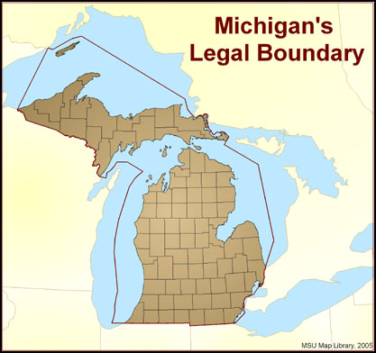
Few published maps show Michigan’s true boundary. Michigan’s legal boundary does not stop at the shoreline of the four Great Lakes that encircle it, but extends into them to include almost 40,000 square miles of water, comprising 40% of Michigan’s area. Most maps of Michigan show only the upper and lower peninsulas plus a few major islands. The U.S. Geological Survey recognizes 420 named islands in the Great Lakes belonging to Michigan.
Since statehood, eight challenges to the boundary have resulted in adjustments that relinquished territory to Minnesota, Wisconsin, and Ohio, but gained territory from Canada.

https://lib.msu.edu/exhibits/map/miboundaries.jsp
Never argue with a fool, onlookers may not be able to tell the difference. - Mark Twain
FEATURED NanoViricides Reports that the Phase I NV-387 Clinical Trial is Completed Successfully and Data Lock is Expected Soon • May 2, 2024 10:07 AM
ILUS Files Form 10-K and Provides Shareholder Update • ILUS • May 2, 2024 8:52 AM
Avant Technologies Names New CEO Following Acquisition of Healthcare Technology and Data Integration Firm • AVAI • May 2, 2024 8:00 AM
Bantec Engaged in a Letter of Intent to Acquire a Small New Jersey Based Manufacturing Company • BANT • May 1, 2024 10:00 AM
Cannabix Technologies to Deliver Breath Logix Alcohol Screening Device to Australia • BLO • Apr 30, 2024 8:53 AM
Hydromer, Inc. Reports Preliminary Unaudited Financial Results for First Quarter 2024 • HYDI • Apr 29, 2024 9:10 AM


