 News
News  Market Data
  Discover
Support: 888-992-3836
Copyright © 2023 InvestorsHub Inc.


Register for free to join our community of investors and share your ideas. You will also get access to streaming quotes, interactive charts, trades, portfolio, live options flow and more tools.
SMXMF registration revoked:
https://www.sec.gov/litigation/opinions/2021/34-92943.pdf
SEC Suspension for severely delinquent Financials:
https://www.sec.gov/litigation/suspensions/2020/34-87980.pdf
Order:
https://www.sec.gov/litigation/suspensions/2020/34-87980-o.pdf
Admin. Proceeding:
https://www.sec.gov/litigation/admin/2020/34-87979.pdf
Anything happening with this company? Their email is dead. They haven't reported in years.
$SMXMF: Seeing some volume here today
Something in the works ?
$0.002
$SMXMF
SMXMF is severely delinquent in filing their Financials and corporate filing obligations to the SEC. On Feb. 20, 2015 the SEC suspended 8 stocks from the Delinquent SEC Filers list, and it is likely that more delinquent Filers will be suspended.
Since Jan 1st, 2010 the SEC has suspended over 1290 stocks for Financials delinquencies. All of those Suspended stocks had their stock registrations revoked.
Shareholders should contact the company and pressure the Mgmt to file their delinquent Financials because ALL shareholders would be wiped out IF the SEC suspends the stock.
SMXMF is on the list of delinquent filers:
http://investorshub.advfn.com/boards/read_msg.aspx?message_id=110680509
$SMXMF > Technical bounce watch this week >
SMXMF has hit the ol' scanner and has a fair chance of a bounce at these levels. Stocks that have declined this badly almost always retrace higher, bounce or dip some and come right back to this point before a further decline.
Contacting me with the fundamentals about the company does not change my criteria for scanning stocks.
If you just started shorting this stock, it might be a bad idea as this is totally oversold!

All of the "FASTLANE's BOMB's AWAY! SCANS" are of my own opinion and not to be used as investment advice.

$SMXMF - Investorshub Trades ~ http://ih.advfn.com/p.php?pid=trades&symbol=SMXMF
$SMXMF - Investorshub Board Search ~ http://investorshub.advfn.com/boards/getboards.aspx?searchstr=SMXMF
$SMXMF - Investorshub PostStream ~ http://investorshub.advfn.com/boards/poststream.aspx?ticker=SMXMF
$SMXMF - Investorshub Messages ~ http://investorshub.advfn.com/boards/msgsearch.aspx?SearchStr=SMXMF
$SMXMF - Investorshub Videos ~ http://ih.advfn.com/p.php?pid=ihvse&ihvqu=SMXMF
$SMXMF - Investorshub News ~ http://ih.advfn.com/p.php?pid=news&btn=s_ok&ctl00%24sb3%24tbq1=Get+Quote&as_values_IH=&ctl00%24sb3%24stb1=Search+iHub&symbol=SMXMF&s_ok=OK&from_month=3&from_day=15&from_year=2012&order=desc&selsrc%5B%5D=prnca&selsrc%5B%5D=prnus&selsrc%5B%5D=zacks&selsrc%5B%5D=money2&selsrc%5B%5D=djn&selsrc%5B%5D=bw&selsrc%5B%5D=globe&selsrc%5B%5D=edgar&selsrc%5B%5D=mwus&force=1&last_ts=1331855999&p_n=1&p_count=&p_ts=1331794260


Regular Candlestick Chart: http://stockcharts.com/h-sc/ui?s=SMXMF&p=D&b=3&g=0&id=p04384940601

Regular Candlestick Chart: http://stockcharts.com/h-sc/ui?s=SMXMF&p=W&b=3&g=0&id=p04384940601


PennyStockTweets ~ http://www.pennystocktweets.com/stocks/profile/SMXMF

OTC Markets Company Info ~ http://www.otcmarkets.com/stock/SMXMF/company-info
$SMXMF - OTC Markets Charts ~ http://www.otcmarkets.com/stock/SMXMF/chart
$SMXMF - OTC Markets Quote ~ http://www.otcmarkets.com/stock/SMXMF/quote
$SMXMF - OTC Markets News ~ http://www.otcmarkets.com/stock/SMXMF/news
$SMXMF - OTC Markets Financials ~ http://www.otcmarkets.com/stock/SMXMF/financials
$SMXMF - OTC Markets Short Sales ~ http://www.otcmarkets.com/stock/SMXMF/short-sales
$SMXMF - OTC Markets Insider Disclosure ~ http://www.otcmarkets.com/stock/SMXMF/insider-transactions
$SMXMF - OTC Markets Research Reports ~ http://www.otcmarkets.com/stock/SMXMF/research

Google Finance Summary ~ http://www.google.com/finance?q=SMXMF
$SMXMF - $SMXMF - Google Finance News ~ http://www.google.com/finance/company_news?q=SMXMF
$SMXMF - Google Finance Option chain ~ http://www.google.com/finance/option_chain?q=SMXMF
$SMXMF - Google Finance Financials ~ http://www.google.com/finance?q=SMXMF&fstype=ii#
$SMXMF - Google Finance Historical prices Daily ~ http://www.google.com/finance/historical?q=SMXMF
$SMXMF - Google Finance Historical prices Weekly ~ http://www.google.com/finance/historical?q=SMXMF&histperiod=weekly#

Y! < Company >
$SMXMF - Y! Profile ~ http://finance.yahoo.com/q/pr?s=SMXMF+Profile
$SMXMF - Y! Key Stat's ~ http://finance.yahoo.com/q/ks?s=SMXMF+Key+Statistics
$SMXMF - Y! Headlines ~ http://finance.yahoo.com/q/h?s=SMXMF+Headlines
$SMXMF - Y! Summary ~ http://finance.yahoo.com/q?s=SMXMF
$SMXMF - Y! Historical Prices ~ http://finance.yahoo.com/q/hp?s=SMXMF+Historical+Prices
Y! Order Book ~ http://finance.yahoo.com/q/ecn?s=SMXMF+Order+Book
Y! Message Boards ~ http://messages.finance.yahoo.com/mb/SMXMF
Y! Market Pulse ~ http://finance.yahoo.com/marketpulse/SMXMF
Y! Technical Analysis ~ http://finance.yahoo.com/q/ta?s=SMXMF+Basic+Tech.+Analysis
Y! < Analyst Coverage >
Y! Analyst Opinion ~ http://finance.yahoo.com/q/ao?s=SMXMF+Analyst+Opinion
Y! Analyst Estimates ~ http://finance.yahoo.com/q/ae?s=SMXMF+Analyst+Estimates
Y! Research Reports ~ http://finance.yahoo.com/q/rr?s=SMXMF+Research+Reports
Y! Star Analysts ~ http://finance.yahoo.com/q/sa?s=SMXMF+Star+Analysts
Y! < Ownership >
Y! Major Holders ~ http://finance.yahoo.com/q/mh?s=SMXMF+Major+Holders
Y! Insider Transactions ~ http://finance.yahoo.com/q/it?s=SMXMF+Insider+Transactions
Y! Insider Roster ~ http://finance.yahoo.com/q/ir?s=SMXMF+Insider+Roster
Y! < Financials >
Y! Income Statement ~ http://finance.yahoo.com/q/is?s=SMXMF+Income+Statement&annual
Y! Balance Sheet ~ http://finance.yahoo.com/q/bs?s=SMXMF+Balance+Sheet&annual
Y! Cash Flow ~ http://finance.yahoo.com/q/cf?s=SMXMF+Cash+Flow&annual

FINVIZ ~ http://finviz.com/quote.ashx?t=SMXMF&ty=c&ta=0&p=d

CandlestickChart ~ http://www.candlestickchart.com/cgi/chart.cgi?symbol=SMXMF&exchange=US

$SMXMF - Barchart Quote ~ http://barchart.com/quotes/stocks/SMXMF?
Barchart Detailed Quote ~ http://barchart.com/detailedquote/stocks/SMXMF
Barchart Options Quotes ~ http://barchart.com/options/stocks/SMXMF
Barchart Technical Chart ~ http://barchart.com/charts/stocks/SMXMF&style=technical
Barchart Interactive Chart ~ http://barchart.com/charts/stocks/SMXMF&style=interactive
Barchart Technical Analysis ~ http://barchart.com/technicals/stocks/SMXMF
Barchart Trader's Cheat Sheet ~ http://barchart.com/cheatsheet.php?sym=SMXMF
Barchart Barchart Opinion ~ http://barchart.com/opinions/stocks/SMXMF
Barchart Snapshot Opinion ~ http://barchart.com/snapopinion/stocks/SMXMF
Barchart News Headlines ~ http://barchart.com/news/stocks/SMXMF
Barchart Profile ~ http://barchart.com/profile//SMXMF
Barchart Key Statistics ~ http://barchart.com/profile.php?sym=SMXMF&view=key_statistics

OTC: American Bulls ~ http://www.americanbulls.com/StockPage.asp?CompanyTicker=SMXMF&MarketTicker=OTC&TYP=S
NASDAQ: American Bulls ~ http://www.americanbulls.com/StockPage.asp?CompanyTicker=SMXMF&MarketTicker=NASD&TYP=S
NYSE: American Bulls ~ http://www.americanbulls.com/StockPage.asp?CompanyTicker=SMXMF&MarketTicker=NYSE&Typ=S

Marketwatch Profile ~ http://www.marketwatch.com/investing/stock/SMXMF/profile
Marketwatch Analyst Estimates ~ http://www.marketwatch.com/investing/stock/SMXMF/analystestimates
Marketwatch Historical Quotes ~ http://www.marketwatch.com/investing/stock/SMXMF/historical
Marketwatch Financials ~ http://www.marketwatch.com/investing/stock/SMXMF/financials
Marketwatch Overview ~ http://www.marketwatch.com/investing/stock/SMXMF
Marketwatch SEC Filings ~ http://www.marketwatch.com/investing/stock/SMXMF/secfilings
Marketwatch Picks ~ http://www.marketwatch.com/investing/stock/SMXMF/picks
Marketwatch Hulbert ~ http://www.marketwatch.com/investing/stock/SMXMF/hulbert
Marketwatch Insider Actions ~ http://www.marketwatch.com/investing/stock/SMXMF/insideractions
Marketwatch Options ~ http://www.marketwatch.com/investing/stock/SMXMF/options
Marketwatch Charts ~ http://www.marketwatch.com/investing/stock/SMXMF/charts
Marketwatch News ~ http://bigcharts.marketwatch.com/news/symbolsearch/symbolnews.asp?news=markadv&symb=SMXMF&sid=1795093&framed=False

The Lion ~ http://thelion.com/bin/aio_msg.cgi?cmd=search&msg=&si=1&tw=1&tt=1&rb=1&ih=1&fo=1&iv=1&yf=1&sa=1&fb=1&gg=1&symbol=SMXMF

Search NYSE ~ http://www.nyse.com/about/listed/lcddata.html?ticker=SMXMF

StockTA ~ http://www.stockta.com/cgi-bin/analysis.pl?symb=SMXMF&num1=567&cobrand=&mode=stock

StockHouse ~ http://www.stockhouse.com/financialtools/sn_overview.aspx?qm_symbol=SMXMF
StockHouse Delayed LII ~ http://www.stockhouse.com/financialtools/sn_level2.aspx?qm_page=46140&qm_symbol=SMXMF

AlphaTrade ~ http://tools.alphatrade.com/index.php?t1=mc_quote_module&t2=mc_quote_module2&t3=historical&template=historical2html&sym=SMXMF&client_id=2740&a_width=680&a_height=1000&language=english&showVol=1&chtype=8

Reuters ~ http://www.reuters.com/finance/stocks/companyOfficers?symbol=SMXMF.PK&WTmodLOC=C4-Officers-5

StockWatch ~ http://www.stockwatch.com/Quote/Detail.aspx?symbol=SMXMF®ion=U

Search NASDAQ ~ http://www.nasdaq.com/symbol/SMXMF
NASDAQ Divy History ~ http://www.nasdaq.com/symbol/SMXMF/dividend-history
NASDAQ Short Interest ~ http://www.nasdaq.com/symbol/SMXMF/short-interest
NASDAQ Institutional Ownership ~ http://www.nasdaq.com/symbol/SMXMF/institutional-holdings
NASDAQ FlashQuotes ~ http://www.nasdaq.com/aspx/flashquotes.aspx?symbol=SMXMF&selected=SMXMF
NASDAQ InfoQuotes ~ http://www.nasdaq.com/aspx/infoquotes.aspx?symbol=SMXMF&selected=SMXMF
NASDAQ After Hours Quote ~ http://www.nasdaq.com/symbol/SMXMF/after-hours
NASDAQ Pre-Market Quote ~ http://www.nasdaq.com/symbol/SMXMF/premarket
NASDAQ Historical Quote ~ http://www.nasdaq.com/symbol/SMXMF/historical
NASDAQ Option Chain ~ http://www.nasdaq.com/symbol/SMXMF/option-chain
NASDAQ Company Headlines ~ http://www.nasdaq.com/symbol/SMXMF/news-headlines
NASDAQ Press Releases ~ http://www.nasdaq.com/symbol/SMXMF/news-headlines
NASDAQ Sentiment ~ http://www.nasdaq.com/symbol/SMXMF/sentiment
NASDAQ Analyst Summary ~ http://www.nasdaq.com/symbol/SMXMF/analyst-research
NASDAQ Guru Analysis~ http://www.nasdaq.com/symbol/SMXMF/guru-analysis
NASDAQ Stock Report ~ http://www.nasdaq.com/symbol/SMXMF/stock-report
NASDAQ Competitors ~ http://www.nasdaq.com/symbol/SMXMF/competitors
NASDAQ Stock Consultant ~ http://www.nasdaq.com/symbol/SMXMF/stock-consultant
NASDAQ Stock Comparison ~ http://www.nasdaq.com/symbol/SMXMF/stock-comparison
NASDAQ Call Transcripts ~ http://www.nasdaq.com/symbol/SMXMF/call-transcripts
NASDAQ Annual Reports ~ http://www.nasdaq.com/aspx/annualreport.aspx?symbol=SMXMF&selected=SMXMF
NASDAQ Financials ~ http://www.nasdaq.com/symbol/SMXMF/financials
NASDAQ Revenue & Earnings Per Share (EPS) ~ http://www.nasdaq.com/symbol/SMXMF/revenue-eps
NASDAQ SEC Filings ~ http://www.nasdaq.com/symbol/SMXMF/sec-filings
NASDAQ Ownership Summary ~ http://www.nasdaq.com/symbol/SMXMF/ownership-summary
NASDAQ Institutional Ownership ~ http://www.nasdaq.com/symbol/SMXMF/institutional-holdings
NASDAQ (SEC Form 4) ~
--------- All Trades ~ http://www.nasdaq.com/symbol/SMXMF/insider-trades
--------- Buys ~ http://www.nasdaq.com/symbol/SMXMF/insider-trades/buys
--------- Sells ~ http://www.nasdaq.com/symbol/SMXMF/insider-trades/sells

The Motley Fool ~ http://caps.fool.com/Ticker/SMXMF.aspx
The Motley Fool Earnings/Growth ~ http://caps.fool.com/Ticker/SMXMF/EarningsGrowthRates.aspx?source=itxsittst0000001
The Motley Fool Ratios ~ http://caps.fool.com/Ticker/SMXMF/Ratios.aspx?source=itxsittst0000001
The Motley Fool Stats ~ http://caps.fool.com/Ticker/SMXMF/Stats.aspx?source=icasittab0000006
The Motley Fool Historical ~ http://caps.fool.com/Ticker/SMXMF/Historical.aspx?source=icasittab0000004
The Motley Fool Scorecard ~ http://caps.fool.com/Ticker/SMXMF/Scorecard.aspx?source=icasittab0000003
The Motley Fool Statements ~ http://caps.fool.com/Ticker/SMXMF/Statements.aspx?source=icasittab0000009

MSN Money ~ http://investing.money.msn.com/investments/stock-ratings?symbol=SMXMF

YCharts ~ http://ycharts.com/companies/SMXMF
YCharts Performance ~ http://ycharts.com/companies/SMXMF/performance
YCharts Dashboard ~ http://ycharts.com/companies/SMXMF/dashboard

InsideStocks Opinion ~ http://www.insidestocks.com/texpert.asp?sym=SMXMF&code=XDAILY
InsideStocks Profile ~ http://www.insidestocks.com/profile.asp?sym=SMXMF&code=XDAILY
InsideStocks Quote ~ http://www.insidestocks.com/quote.asp?sym=SMXMF&code=XDAILY
InsideStocks Projection ~ http://charts3.barchart.com/procal.asp?sym=SMXMF

Zacks Quote ~ http://www.zacks.com/stock/quote/SMXMF
Zacks Estimates ~ http://www.zacks.com/research/report.php?type=estimates&t=SMXMF
Zacks Company Reports ~ http://www.zacks.com/research/report.php?type=report&t=SMXMF

Knobias ~ http://knobias.10kwizard.com/files.php?sym=SMXMF

StockScores ~ http://www.stockscores.com/quickreport.asp?ticker=SMXMF

Trade-Ideas ~ http://www.trade-ideas.com/StockInfo/SMXMF/HOT_TOPIC.html

Morningstar ~ http://performance.morningstar.com/stock/performance-return.action?region=USA&t=SMXMF&culture=en-US
Morningstar Shareholders ~ http://investors.morningstar.com/ownership/shareholders-overview.html?t=SMXMF®ion=USA&culture=en-us
Morningstar Transcripts~ http://www.morningstar.com/earnings/NoTranscript.aspx?t=SMXMF®ion=USA
Morningstar Key Ratios ~ http://financials.morningstar.com/ratios/r.html?t=SMXMF®ion=USA&culture=en-US
Morningstar Executive Compensation ~ http://insiders.morningstar.com/trading/executive-compensation.action?t=SMXMF®ion=USA&culture=en-us
Morningstar Valuation ~ http://financials.morningstar.com/valuation/price-ratio.html?t=SMXMF®ion=USA&culture=en-us

CCBN (Thompson Reuters) ~ http://ccbn.aol.com/company.asp?client=aol&ticker=SMXMF

TradingMarkets ~ http://pr.tradingmarkets.com/?lid=leftPRbox&sym=SMXMF

OTCBB ~ http://www.otcbb.com/asp/SiteSearch.asp?Criteria=SMXMF&searcharea=e&image1.x=0&image1.y=0

Insidercow ~ http://www.insidercow.com/history/company.jsp?company=SMXMF&B1=Search%21

Forbes News ~ http://search.forbes.com/search/find?tab=searchtabgeneraldark&MT=SMXMF
Forbes Press Releases ~ http://search.forbes.com/search/find?&start=1&tab=searchtabgeneraldark&MT=SMXMF&pub=businesswire,prnewswire&searchResults=pressRelease&tag=pr&premium=on
Forbes Web ~ http://search.forbes.com/search/web?MT=SMXMF&start=1&max=10&searchResults=web&tag=web&sort=null

YouTube Symbol Search ~ http://www.youtube.com/results?search_query=SMXMF

Buy-Ins ~ http://www.buyins.net/tools/symbol_stats.php?sym=SMXMF

Quotemedia ~ http://www.quotemedia.com/results.php?qm_page=47556&qm_symbol=SMXMF

Earnings Whispers ~ http://www.earningswhispers.com/stocks.asp?symbol=SMXMF
Bloomberg Snapshot ~ http://investing.businessweek.com/research/stocks/snapshot/snapshot.asp?ticker=SMXMF
Bloomberg People ~ http://investing.businessweek.com/research/stocks/people/people.asp?ticker=SMXMF
Financial Times ~ http://markets.ft.com/Research/Markets/Tearsheets/Summary?s=SMXMF
Investorpoint ~ http://www.investorpoint.com/ enter "SMXMF" and click search.
Hotstocked ~ http://www.hotstocked.com/ enter "SMXMF" and click search.
Raging Bull ~ http://ragingbull.quote.com/mboard/boards.cgi?board=SMXMF
Hoovers ~ http://www.hoovers.com/search/company-search-results/100003765-1.html?type=company&term=SMXMF
DD Machine ~ http://www.ddmachine.com/default.asp?m=stocktool_frame.asp?symbol=SMXMF
SEC Form 4 ~ http://www.secform4.com/insider/showhistory.php?cik=SMXMF
OTCBB Pulse ~ http://www.otcbbpulse.com/cgi-bin/pulsequote.cgi?symbol=SMXMF
Failures To Deliver ~ http://failurestodeliver.com/default2.aspx enter "SMXMF" and click search.
http://www.coordinatedlegal.com/SecretaryOfState.html
http://regsho.finra.org/regsho-Index.html
http://www.shortsqueeze.com/?symbol=SMXMF&submit=Short+Quote%99
~ $SMXMF ~ Daily Par Sar Buy Signal ~ Criteria alert triggered during a recent trading session!

$SMXMF has just triggered the "Parabolic SAR Buy Signals" scan criteria at Stockcharts.com
~ http://tinyurl.com/SAR-BUY ~


For a more in Depth study and DD profile, similar to the one contained in this link: ~ http://tinyurl.com/DDexample ~
Click the following link and type ticker or brief message asking me about the DD: ~ http://tinyurl.com/GET-THE-DD ~
What does the scan "Parabolic SAR Buy Signals" mean? Below is an image example and study link.
~ http://stockcharts.com/school/doku.php?id=chart_school:technical_indicators:parabolic_sar ~

To find other similar posts of "SMXMF" utilize the links that follow.
Search MACDgyver's "Parabolic SAR Buy Signals" posts: ~ http://investorshub.advfn.com/boards/msgsearchbymember.aspx?searchID=251916&srchyr=2013&SearchStr=ParSarBuyScan ~
Search MACDgyver's posts for symbol "SMXMF": ~ http://investorshub.advfn.com/boards/msgsearchbymember.aspx?searchID=251916&srchyr=2013&SearchStr=SMXMF ~
Search Ihub for "SMXMF" posts: ~ http://investorshub.advfn.com/boards/msgsearch.aspx?SearchStr=SMXMF ~
For more in depth training and information visit Chartschool on the Stockcharts page.
~ http://stockcharts.com/school/doku.php?id=chart_school ~

Also don't forget the Ihub Edu Channel.
~ http://investorshub.advfn.com/boards/education.aspx ~


c
~ $SMXMF ~ Parabolic SAR Buy Signals ~ Criteria alert for last trading session!

$SMXMF has just triggered the "Parabolic SAR Buy Signals" scan criteria at Stockcharts.com
~ http://tinyurl.com/SAR-BUY ~
For a more in Depth study and DD profile, similar to the one contained in this link: ~ http://tinyurl.com/DDexample ~
Click the following link and type ticker or brief message asking me about the DD: ~ http://tinyurl.com/GET-THE-DD ~
What does the scan "Parabolic SAR Buy Signals" mean? Below is an image example and study link.
~ http://stockcharts.com/school/doku.php?id=chart_school:technical_indicators:parabolic_sar ~
To find other similar posts of "SMXMF" utilize the links that follow.
Search FaStlane's "Parabolic SAR Buy Signals" posts: ~ http://investorshub.advfn.com/boards/msgsearchbymember.aspx?searchID=251916&srchyr=2011&SearchStr=ParSarBuyScan ~
Search FaStlane's posts for symbol "SMXMF": ~ http://investorshub.advfn.com/boards/msgsearchbymember.aspx?searchID=251916&srchyr=2011&SearchStr=SMXMF ~
Search Ihub for "SMXMF" posts: ~ http://investorshub.advfn.com/boards/msgsearch.aspx?SearchStr=SMXMF ~
For more in depth training and information visit Chartschool on the Stockcharts page.
~ http://stockcharts.com/school/doku.php?id=chart_school ~
Also don't forget the Ihub Edu Channel.
~ http://investorshub.advfn.com/boards/education.aspx ~
NEWS RELEASE – No. 1-12 March 22, 2012
SAMEX EXPLORATION UPDATE, LOS ZORROS PROJECT, CHILE
SAMEX is steadily advancing the exploration program at its Los Zorros property in Chile. Drilling since mid December includes over 4700 meters in 11 holes (two holes are currently in progress) and has variably encountered anomalous and massive sulphide mineralization including; pathfinder minerals, favourable sedimentary intervals and structurally controlled mineralization. Program highlights include:
• Milagro Project - Drill hole MW-12-01, located on the western edge of the Milagro gravity anomaly, encountered 22 meters of semi-massive to massive sulphide and oxide mineralization, composed of pyrite, magnetite, hematite and chalcopyrite. Logging and sampling is in progress, which will be followed by assaying. A 400 meter step out drill hole, MW-12-02 positioned more central within the Milagro gravity anomaly, has been started to follow up this encouraging intersection.
• Nora Project, Target Zones C/D - Logging, sampling and assaying have been completed on the four holes within the project area, N-11-01A, B, C and N-11-02A. Results are discussed below. Please also see PDF graphics plate at www.samex.com for map and section views.
• Nora Project, Target Zones A/B - Three deep holes have been drilled, N-11-03, -04, N-12-05 and a fourth N-12-06 is in progress. Logging, sampling and assaying are in progress and will be reported when completed.
• Lora SE Project - Two holes, LSE-12-01, -02 were drilled in this project area to test geophysical gravity low, resistivity and chargeability anomalies - intercepts of mineralized quartz-eye diorite porphyry and altered mineralized sediments were encountered. Logging, sampling and assaying are in progress and will be reported when completed.
• Cinchado Project - One deep drill hole SP-12-01, has been completed from the east side of Cinchado towards the west and underneath the old San Pedro gold mine. Logging, sampling and assaying are in progress and will be reported when completed.
• Drill pads have been prepared for continuation of drilling at the Virgen del Carmen, Colorina, Milagro, Florida, and the Salvadora project areas. Additional drill pads are in the process of being constructed in other project areas.
• A new road to access the more northern Cresta de Gallo area is under construction along the eastern range front region of the property. Current drilling at the Los Zorros Property is exploring for gold and silver at multiple project areas within the Company’s extensive land holdings that now cover more than 100 square kilometers. This round of drilling is following up exploration results from earlier drilling and is also testing anomalies identified by the Titan-24 geophysical survey which was completed last year.
Nora Project, Target Zones C/D - SAMEX has been drilling in the Nora Project area which hosts a complex swarm of copper-gold-mineralized barite veins and a series of broad zones of anomalous gold. Assay results have been received and compiled for four of the holes (DDH-N-11-01A, -01B, - 01C and N-11-02A) drilled in Zone C and Zone D of the Nora Project area. The holes were designed to follow-up on a significant interval of high-grade gold mineralization (15.96 g/t over 7.66 meters) in pyritized and silicified diorite-clast breccia intercepted in drill hole N-04-05 during 2004, and to test a target concept to determine if a gold-mineralized breccia mantos/stratigraphic unit was possibly widespread beneath the area.
A set of three drill holes (DDH-N-11-01A, N-11-01B, N-11-01C) were drilled at various angles from the same pad location (drill pad N-11-01) in order to test the concept of a mantos/stratigraphic control. A fourth drill hole (DDH-N-11-02A) was positioned to drill steeply southeastward across the target interval in similar fashion to the nearby original 2004 “discovery” drill hole. Three of the holes (DDH-N-11-01A, N-11-01B, and N-11-02A) holes made successful intact intersections through the targeted stratigraphic interval of “black silica” matrix diorite breccia, and hole N-11-01C intersected a similar layer much higher in the hole than anticipated - but the intersections in these mantos/stratigraphic units did not have any significant gold content.
However, highly anomalous amounts of gold and silver with highly anomalous copper were intersected from the surface (or near surface) to depths of about 40.0 to 60.0 meters in all three of the holes (DDH-N-11-01A, N-11-01B, N-11-01C) drilled from drill pad N-11-01) (see Table below). These shallow intersections appear to be related to two strongly quartz-sericite-pyrite altered vein/fault zones which trend through the vicinity of the drill pad (N-11-01). The respective true widths of these intersections can only be estimated to be between 5 to 16 meters because the orientation of the drill holes is angled at a very acute angle (<100 to 200) to the steep westward dip of the vein/faults, thus smearing out the highly fractured intersections (see cross section figure). Because of the highly fractured rock, core recovery in these intervals was overall poor. Other intervals of anomalous gold and copper were also intersected at greater depths in these holes and appear to be related to quartzsericite-pyrite altered vein/faults.
The additional information gleaned in these recent drill holes suggests that the interval of high-grade gold mineralization intersected in 2004 may be related to one of the steep (near vertical) fault/vein structures – perhaps comprising part of the wide mineralized quartz-sericite-pyrite alteration halo - instead of being part of a mantos-style (near horizontal/stratigraphic) layer. The intervals of highly anomalous gold and silver with highly anomalous copper in these new holes all appear to be associated with quartz-sericite-pyrite altered fault/veins (vertical/steep oriented structures).
The complex swarm of copper-gold-mineralized barite veins and broad zones of anomalous gold present at surface in the Nora Project area may be leakage up from deeper-seated mineralization in vertical/steep oriented structures beneath the area. The recent drill holes (DDH-N-11-01A, -01B, - 01C) were oriented as steep-angle holes in order to test through mantos-style (near horizontal/stratigraphic) layers; however, a program of low-angled holes would need to be considered in order to test the nature and true width of vertical/steep oriented structures at depth in prospective Zones C and D and in the broader and more-strongly veined prospective Zone A.
The Los Zorros land holdings now cover a 15 kilometer-strike of the prospective range front/anticline along which mineralization is exposed in old-time piquenero underground workings, open cuts, trenches and pits situated in the Colorina, Nora, Virgen del Carmen, Cresta de Gallo, and Trueno project areas that are yet to be systematically explored by SAMEX.
SAMEX is making steady progress in exploring this large and complex district and continues to develop a clearer understanding of the controls and influences that gave rise to mineralization on the property. SAMEX is well funded to advance the exploration of its high-priority precious metal projects at Los Zorros, while bringing forward numerous additional targets in the district. The Company holds a portion of its working capital in the form of gold and silver bullion.
The geologic technical information in this News Release was prepared by Robert Kell, Vice-President Exploration for SAMEX MINING CORP. and Philip Southam, Geologist. Mr. Kell and Mr. Southam are “qualified persons” pursuant to Canadian Securities National Instrument 43-101 concerning Standards Of Disclosure For Mineral Projects.
http://www.samex.com/files/6513/3245/3928/NR1-12-Mar22.pdf
SAMEX Answers Sasco
Date : 12/21/2011 @ 4:11PM
One of our shareholders, Sasco Investments, of Houston, Texas, published a letter on December 15, 2011 critical of SAMEX (TSX:VENTURE:SXG)(OTCBB:SMXMF) management and the speed of exploration work on SAMEX's Los Zorros property.
We are deeply disappointed with Sasco and its principal, Mr. Sadeghpour.
As a major investor, Sasco and Mr. Sadeghpour have been given extensive access to SAMEX's geological team and management - under terms of a confidentiality agreement (which may now be in breach) - they know - or ought to know - full well the things they now say are untrue.
Also, while SAMEX has always been open to comments and ideas from Sasco or other shareholders - even critical or misguided ones - Sasco has chosen to communicate by demands and defamatory letters - not by dialogue and discussion.
Sasco first contacted the Board with its complaints by letter dated December 12, 2011 making much the same complaints as in its "open letter". The Board met the next day (December 13), and, because of the nature of the complaints, formed an independent committee to deal with them. The Committee sent Sasco a letter on December 14, 2011 offering to engage in open and frank discussion. Instead of making a phone call, Sasco chose to publish its "open letter" on December 15, 2011, and has yet to respond to our invitation.
Sasco's action has left us little choice but to respond publicly and in writing.
While we take exception to most of Sasco's letter, there a few points on which we both agree. We agree that Los Zorros is an impressive property. We agree that it should be explored aggressively. We appreciate Sasco's confidence in our geological team which Sasco says is 'brilliant'. What we do not agree on is that Sasco/Sadeghpour - who to our knowledge have no experience or qualifications in geology - can run our drill programs better than our professional geological team.
Some of Sasco's comments are disingenuous or merely petty. Sasco criticizes the SAMEX website, yet Mr. Sadeghpour personally told SAMEX not to bother changing it. (Incidentally, we do agree the website needed updating. We already had a web designer working on it - as Mr. Sadeghpour knew. The new website is now up and running.)
Other Sasco comments are either seriously misinformed or outright false and misleading.
Sasco makes much of saying SAMEX delayed drilling on the "Nora" portion of the Los Zorros Property "for 10 months". He claims SAMEX "affirmed it would start drilling on the Nora project early in the first quarter of 2011". Sasco then goes on to say first, that drilling did not commence until November 2011 and then, in the next sentence, says that drilling did not resume until July 2011 after completion of the Titan 24 testing in February, 2011.
Aside from being confusing, this comment is completely disingenuous and misleading. Sasco knows full well why drilling was paused in February and resumed in July and why Nora was not drilled in the first quarter of 2011, and fully agreed with those decisions at the time. Sasco had several tours of the Property with SAMEX's chief geologist and CEO, and was fully informed of the activities of the Company during the time period in question.
The facts speak for themselves.
Drilling carried on at Los Zorros until February 3, 2011, then paused to allow completion and interpretation of Titan 24 geophysics survey announced on December 17, 2010. Sasco and its advisors strongly supported completion of the Titan 24 survey to help interpret and model the very complex and varied geology at Los Zorros. After receiving the Titan 24 results in early April, 2011, our geological team spent the next several weeks correlating geophysical results with existing geological data and models. As a result, our team identified a new target at Cinchado - which we announced on April 18, 2011 as our next top priority drilling target. Mr. Sadeghpour evidently agreed with our conclusion because the next day he purchased more than 2.4 million SAMEX shares in the market at prices in excess of $1.00, and continued to buy shares afterwards.
Our geological team continued the process of analysis, modeling, preparation of prioritized drill targets and construction of drill pads in May and June 2011. Drilling recommenced early July 2011 at Cinchado, as announced, and has continued since then at various Los Zorros projects in accordance with the drilling plan established by our professional geological team. The team decided for various reasons (and Sasco and its advisors agreed) to prioritize drilling at Cinchado first and then on other parts of Los Zorros before moving to Nora. This timing had nothing to do with delaying a program or extending 'salary longevity' as Sasco falsely claims - it had everything to do with prudent exploration.
Sasco's comments on hiring new geologists and adding drill rigs are both disingenuous and misleading. Sasco is well aware that SAMEX has been actively recruiting geologists throughout 2011. Exploration activity worldwide has been at an all time high in our industry, making the hiring of experienced geologists very difficult. SAMEX has now hired three additional geologists (for a total of five), and is seeking to hire a sixth. SAMEX practice has been to have two geologists for each rig to ensure adequate supervision and logging - something Sasco knew and agreed with. Our fourth geologist started December 4, only 5 days before the second rig started at Nora.
Sasco also makes a number of comments about SAMEX management and the SAMEX board which are not only false and defamatory, but completely reckless in their disregard for the truth.
Sasco claims SAMEX management is deliberately slowing the pace of work to stretch out their salaries rather than focusing on drilling. Not only is this claim baseless, it also defies common sense. All of SAMEX management have significant share and option positions - they stand to gain much more from a discovery than from years of collecting a salary. In fact, there were sound reasons for pausing drilling until after completion and analysis of geophysics, and there were many other things - both technical and administrative - SAMEX management needed to complete prior to resuming drilling.
In its closing sentence, Sasco says our mission is "drilling our prized projects in Chile". On this we must disagree. While we 'prize' our projects, our mission is not drilling, it is discovery - discovery of a major gold deposit. That takes thoughtful and systematic exploration - something we will continue to do.
Sasco claims none of the six directors adequately represent investors. This is utterly false and completely slanderous. The current board have been directors for over 16 years, other than Malcolm Fraser, who was only elected this year. Every year for the last 16 years more than 90% of all shares voted supported these directors. Until very recently, Sasco and Sadeghpour expressed strong support for the Board, and in fact voted for re-election of the Board at the AGM on June 7, 2011. It is only now, when it suits their purpose, that they make this false and defamatory allegation.
Sasco claims stock options are 'handed out like party favours'. Nothing could be further from the truth. In fact, although TSX policy allows junior companies to grant up to 20% of their issued shares as options, SAMEX options have never reached 10%. While TSX policy permits option grants at a discount to market price (the typical practice for junior exploration companies), almost all SAMEX options have been granted at, or more typically, well above the prevailing market price.
Further, Sasco's proposed plan to improve management - moving the President and CEO to Chile - is seriously misguided. SAMEX is a Canadian public company with a Tier 1 TSX-V listing. Of the 1,600+ mining issuers on the TSX/TSX-V, the vast majority have head offices in Canada. There is good reason for this practice. Canadian public mining companies have extensive regulatory and reporting obligations in Canada, and need to be close to regulators, professional advisors and financing sources here in Canada. While we do maintain a significant office in Copiapo, Chile managed full time by a Chilean mining engineer, we believe that moving our CEO to Chile would seriously hamper meeting our regulatory and other obligations.
Finally, while Sasco talks of 'broken promises' by SAMEX management, when it comes to mis-statements and broken promises, Sasco and Mr. Sadeghpour have themselves indulged in a 'whopper'. Prior to investing in November, 2010 and multiple times since Sasco and Sadeghpour promised to support management and the existing board of directors for at least five years. Numerous drafts of voting agreements were prepared and exchanged - always with the assurance by Sasco and Sadeghpour that they were ready to sign, with only minor changes. Yet now Sasco and Mr. Sadeghpour are seeking to use their voting power to replace half the board with their own nominees. We understand the pressures that can come from exploration challenges and difficult markets, but a promise is a promise. If Sasco and Sadeghpour cannot be trusted to keep their word on this, can they be trusted on anything else?
While Sasco and Sadeghpour's conduct make us suspicious of their motives, we remain open for discussion and again extend our offer to Sasco to engage in open and frank communication with a view to resolving any legitimate concerns.
However, whatever Sasco's decision or response, SAMEX management wishes to assure its shareholders that they will continue to do whatever is necessary to further and protect the interest of all SAMEX shareholders, both large and small.
For And On Behalf Of The Board Of Directors,
Jeffrey Dahl, President
http://www.samex.com/files/9613/2450/1440/NR10-11-Dec21.pdf
Financials for quarter ending March 31, 2011:
http://www.sec.gov/Archives/edgar/data/766504/000113717111000362/financials.htm
Key points:
* 122,285,219 outstanding shares. Increase of 2,817,500 shares based on warrant exercises.
* $668,596 spent on Los Zorros exploration, mapping, etc.
SMXMF's chart has been heating up since the July 11, 2011 PR announcing that drilling will recommence on Los Zorros. I'm bummed that I missed this announcement while on vacation.

SAMEX TO RESUME DRILLING AT LOS ZORROS DISTRICT, CHILE
Drilling will resume shortly at Los Zorros in Chile where SAMEX is exploring for multiple precious metal deposits within a district of widespread occurrences of gold, silver, copper and barite.
The drilling is following up exploration results from earlier drilling and a Titan-24 geophysical survey which refined understanding of existing project targets and also outlined important new targets (see News Release No. 4-11 dated April 18, 2011 "SAMEX Makes Exploration Breakthrough At Cinchado; Multiple Gold Intercepts At Milagro & Milagro Pampa – Los Zorros District, Chile" and graphic plates at www.samex.com). Drilling will start in the Cinchado Project area and is also planned for the high priority Nora Project. In addition, other targets outlined by the Titan 24 geophysical survey and recent reconnaissance work may be tested later in the program.
The Los Zorros property holdings consist of multiple project areas that cover approximately 80 square kilometers within a district of scattered numerous small mines and prospects where there was
sporadic attempts at small-scale production for gold and copper-silver in the past. The property is situated at the convergence of important geologic and structural features and significant gold and
copper-silver mineralized areas of Cinchado, Nora, Milagro, and Milagro Pampa. There are also many other mineral occurrences at Los Zorros yet to be systematically explored by SAMEX including: La
Florida and Lora (gold and copper-gold), Virgen de Carmen and Colorina (copper-silver; possible deeper-seated gold and copper-gold), and Salvadora and Cresta de Gallo (barite vein systems with possible deeper-seated gold and copper-gold). In addition to these areas, SAMEX is strategically expanding its Los Zorros land holdings over prospective geologic features in the surrounding area.
SAMEX is well funded to advance the exploration of its high-priority precious metal projects at Los Zorros, while bringing forward numerous additional targets in the district.
“Jeffrey Dahl”
http://www.samex.com/news/aa-news-2011/NR7-11-Jul8.pdf
Samex mentioned in May 2011 Clive Maund interview:
TGR: What about the Chilean economy, especially as it pertains to mining?
CM: Chile is actually a far more fiscally prudent country than the U.S. It does not have careening deficits, and the workforce is obliged to contribute to a private pension scheme that has in fact grown in value far more than government schemes in countries like the U.S. That means the Chilean government is not on the hook for massive pension obligations, as many other governments around the world are. Those governments will probably renege on these obligations, at least in part, by a combination of inflation and fiddling the inflation statistics.
Chile is very mining friendly and has a sophisticated infrastructure to support mining companies conducting operations. In addition, environmental factors are not such a concern here as most of the mining operations and prospects are located in northern Chile. The north is a rather sparsely populated desert but with towns dotted around to provide amenities, logistical support and a skilled workforce. It is still not widely appreciated that there is a line of hills or low mountains between the Andes and the coast that harbor massive as-yet-undiscovered copper-gold deposits that will be relatively easy to mine and much less complicated and expensive than Barrick Gold Corp.'s (TSX:ABX; NYSE:ABX) massive Pascua-Lama operation. That project is perched on Chile's border with Argentina, high in the Andes. To get an idea of the potential of these deposits located in this line of hills, you need only look at Codelco's (Corporacion Nacional del Cobre de Chile) massive
Chuquicamata Chuquicamata
open-pit copper mine near Calama, which is the biggest open-pit copper mine in the world, or Freeport-McMoRan Copper & Gold Inc.'s (NYSE:FCX) giant Candelaria open-pit and underground mine near Copiapo.
TGR: You have an on-the-ground view of what's happening in Chile. Are there some small-cap names with favorable projects in Chile?
CM: One that is coming along very nicely and continues to look most promising is Samex Mining Corp. (TSX.V:SXG; OTCBB:SMXMF). I have personally inspected its properties north and south of Copiapo with the company's chief geologist. I started the current bull market in this stock by recommending it to subscribers at $0.12 almost two years ago and, after a steady advance, it spiked for about a month on positive drilling results. Samex has tied up two nice parcels of excellent properties on that line of hills I mentioned earlier, which are actually very close to Freeport's Candelaria operation. These properties have huge potential, so there's a lot more upside for this stock with the company now undertaking a drilling program to define the potential of the properties.
http://www.gold-speculator.com/gold-report/55865-clive-maund-mitigate-investment-risk-until-end-dollar-rally.html
Thanks for sharing the information. Hope they start drilling next month.
Talked with management today after first post.
I had a great conversation today with Samex management, and wanted to share with other stakeholders. Management answered all questions, explained in detail the vision for company in relation to existing projects and future ventures. I am more excited than ever before with the potential and direction of Samex Mining. They expect more drill results late summer from multiple mines that should be extremely beneficial to all shareholders.
Does anyone have information on when Samex will be releasing the updates on the Cinchado drilling. Initially the Titan 24 was not available on the last drill results, but once they used it it allowed then to pinpoint new drilling spots.
Any info would be greatly appreciated
Need a high volume day to push back above the 50ma and create support. ?
March 16, 2011 warrants extended to 2012
SAMEX MINING CORP. ("SXG")
BULLETIN TYPE: Warrant Term Extension
BULLETIN DATE: February 28, 2011
TSX Venture Tier 1 Company
TSX Venture Exchange has consented to the extension in the expiry date of the following warrants:
Private Placement:
# of Warrants: 2,871,250
Original Expiry Date of Warrants: March 16, 2009, extended to March 16, 2011
New Expiry Date of Warrants: March 16, 2012
Exercise Price of Warrants: $1.00
These warrants were issued pursuant to a private placement of 5,742,500 shares with 5,742,500 share purchase warrants attached, which was accepted for filing by the Exchange effective March 16, 2007.
$1.00 is always somewhat of a barrier. Once broken the mystic fades and we can get on with business.
Looks like SMXMF is gapping up today. .988 x .101 in pre-market.
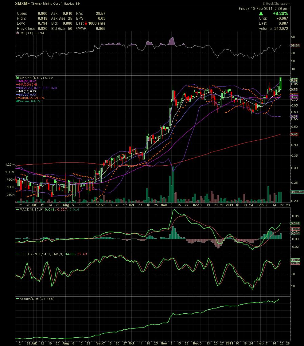
Nice day so far! SMXMF finally broke that stubborn resistance in the .83 range. Now trading at .89 on strong volume. Chart is looking beautiful right now. A close at this level would set up a strong week next week.
16 Month Old Report on Samex, but still good information.
SAMEX MINING CORP: A Very Special Report
By Clive Maund
Published: October 28, 2009 by GoldSpeculator
------------------------------------------------------------------
On 17th October 2009 the Maund brothers, senior independant geologist Nigel Maund and stockmarket analyst Clive Maund visited Samex Mining Corp's Chimberos prospect in northern Chile with Samex President and Director Jeff Dahl and VP Exploration and Director Robert Kell. A complete assessment of the geologic potential of the prospect was undertaken by Nigel Maund and an update on the potential for the stock based on technical analysis has been added by Clive Maund. What follows below is a two part article featuring this work.
PART 1: Nigel Maund's Fundamental Analysis of SAMEX MINING CORP.
by Nigel H Maund
BSc(Hons)Lond. MSc, DIC, MBA, F.AusIMM, F.AIG, F.SEG, MIMMM
Westralian Exploration Consultants Limited (Australia) – Principal Geologist
TICKER – SXG.V
SAMEX MINING CORP: CHIMBEROS Cu – Au – Ag PROSPECT REVIEW - CHILE
“THE GEOLOGIC SCENE IS SET FOR A MAJOR IOCG DISCOVERY”
The writer visited the Chimberos Prospect in Region III of Chile with this website owner Clive Maund and SAMEX Directors, Mr. Jeff Dahl and Mr. Rob Kell on the 17th October 2009. A complete geologic review of the prospect was undertaken with a view to its overall exploration potential.
The location of the Chimberos Prospect is given on Plate 2 below together with other SAMEX properties in the region. SAMEX tenement holdings over this prospect are given on Plate 4 further down the page. A substantial Chilean mining company, Sociedad Contractuel Minera Carola (Carola), holds title to the balance of the ground over the Chimberos prospect. This company is currently mining one of the long established Punte del Cobre copper – gold mines immediately south and east of the regional centre of Copiapo (150,000 inhabitants) in Region III of Chile, as shown on Plate 2. The latter has produced more than 140Mt at a grade of nearly 2% Cu and 0.4 g/t Au, from extensive underground mines, working vein breccia and stacked manto deposits, developed on the NE flank of the large Candeleria open pit copper – gold mine, which is now owned and operated by Freeport McMoRan. Carola currently has three large diamond rigs drilling 600m to 800m deep and steep angled holes, as shown on Plates 1 and 4, in an initial 10,000m program. Their target is a Candelaria type IOCG (Iron Oxide Copper Gold) porphyry system with associated Punte del Cobre type higher grade copper – gold manto and vein breccia deposits which occur as stacked systems astride high angle to vertical input feeder structures. The Candeleria / Punte del Cobre system hosts a resource of some 5 to 7 Mt of copper metal and 3 to 5 M oz gold, making it a Class II copper – gold resource. This counts as a major exploration target.

Plate 1: A Sociedad Contractuel Minera Carola truck mounted diamond rig drilling an angled hole towards and near the boundary of SAMEX tenements at the Chimberos prospect - Chile
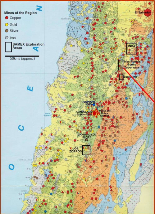
Plate 2: The location of the Buena Esperanza – Tres Puntas (Chimberos) Prospects – Region III – Chile – Metallogenic Geologic Map (SERNAGEOMIN). Red line points to Chimberos prospect.
The Candelaria Mine, illustrated on Plate 9, contains greater resources than the out-of-date published reserves of 450Mt at 1.0% Cu and 0.30 g/t Au and is the most significant mineral deposit in Chile’s Coastal Cordillera belt. Owing to the complex tenement holdings around Candelaria, Freeport’s scope for reserve expansion around the drilled out deposit is somewhat restricted. Hence, the reserve does not reflect the full scale of the Candeleria resource. The latter is thought to be in the vicinity of 1 Gt of similar grades from exploration drilling undertaken on adjacent ground.
SAMEX has to date largely focused their activities on securing all the tenements and in undertaking exploration work at their “Los Zorros” complex of prospects located some 60km south of Copiapo. Rob Kell has been assembling the SAMEX tenement package in Chile based on sound geologic area selection principles and his own extensive industry experience. The Chimberos prospect was built around the old Buena Esperanza silver – copper mines shown on Plate 2 and illustrated on Plates 3 and 4. These workings have extracted high grade silver and copper ores, principally as native silver, oxides and from disseminated metal sulfides, including freibergite – cuprite – chalcocite and chalcopyrite over more than 120 years. The workings extend to depths of up to 150m below surface in substantial vertical shafts and Buena Esperanza was the third largest silver producer up until the establishment of the huge mechanized porphyry copper mines in Chile. The structure that controls the vein and manto style deposits at Buena Esperanza can be traced along strike for more than 6km to the mine workings at Tres Punta to the north, and hence is a major geologic feature. At surface the mineral assemblage is high level epithermal to upper mesothermal with localized high grade gold – silver veining and replacement bodies, and copper – gold – silver. However, at depth it is strongly suspected that this mineralization style will morph into Punte del Cobre copper - gold type structure – lithology controlled steep vein breccia and gently dipping stacked “manto” replacement deposits offering significant tonnage potential.

Plate 3: A view south along the Buena Esperanza silver - gold - copper workings located entirely within SAMEX tenements at the Chimberos Prospect. The structural control to mineralization is apparent on the plate.
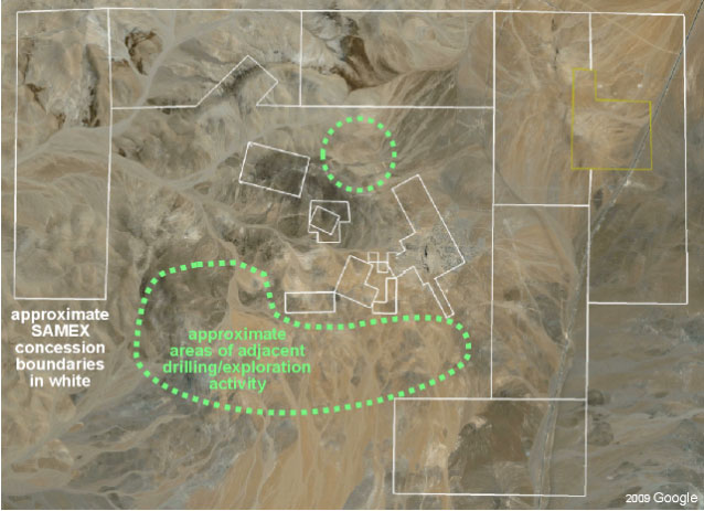
Plate 4: A Google Earth image showing the location of SAMEX tenements and areas where Sociedad Contractuel Minera Carola are currently drilling in their Phase 1 diamond drilling program.
Furthermore, and perhaps more significantly, the hydrothermal alteration envelope, in terms of mineralogy and scale, identified by SAMEX, and substantiated by the writer, points to a major IOCG system of the Candelaria type developed at unknown depth beneath the Chimberos project. However, the expected depth is unlikely to be more than a few hundred meters, given the hydrothermal alteration mineral assemblage and sheer scale of the alteration developed, as apparent on Plate 8. The geologic stratigraphy exposed on the property reveals members of the Abundancia Formation which comprises a sequence of interbedded limestones and andesitic volcaniclastic rocks. This formation is underlain by the main ore host at Punte del Cobre and Candeleria mines; i.e., the Punte del Cobre formation, which comprises a suite of andesitic volcanic lavas, tuffs, agglomerates and lahars (collectively known as volcaniclastics). At Chimberos, the writer observed major hydrothermal alteration and skarn development in the Abundancia Formation members with coarse andradite (garnet) – epidote – chlorite – carbonate ± specular hematite skarn rocks suggestive of proximal development to the heat source. This tabular gently south dipping skarn body is immediately underlain by substantial manto copper – gold mineralisation, developed over a distance of 1.5km as chrysocolla, cuprite, chalcocite and chalcopyrite as shown on Plates 5 and 6. This mineralization underlies the SAMEX tenements. There is evidence exposed on the Chimberos prospect of stacked skarn and copper – gold manto bodies typical of the Punte del Cobre style of mineralization. These areas have never been tested by drilling.
Table 1, below, has been prepared to summarize for the investor the main features of the Chimberos prospect. From Plate 4 above, it is apparent that SAMEX possesses a strategic tenement holding in the unfolding exploration play currently underway. Furthermore, the location of any resource defined by exploration drilling within 2 to 4 km from an “A” class asphalted road could hardly be better. The only problem the writer can foresee will be the availability of water. The terrain itself poses no problems to exploration or subsequent development.
SAMEX’s strategy should now be focused towards drill testing the deeper potential of the Buena Esperanza mine workings for Punte del Cobre copper – gold – silver mineralization where a substantial tonnage of stacked manto deposits may be expected. SAMEX are very well placed to benefit from the positive results of the unfolding IOCG exploration play currently underway, as Carola will be strongly constrained in any potential mine development by the SAMEX ground holding, as evidenced on Plate 4.

Plate 5: Copper Manto development immediately beneath the andradite garnet – epidote – carbonate – hematite skarn with blue (chrysocolla) – cuprite – chalcocite (grey) and ochreous hematite – limonite developed in the oxide zone after copper sulfides.
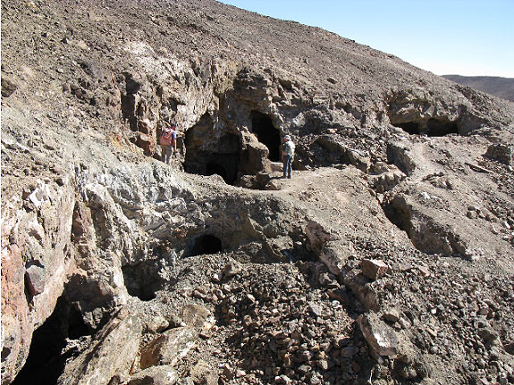
Plate 6: Extensive local miner (picaneros) workings developed within the copper gold manto immediately beneath the andradite – grossular – epidote – carbonate – hematite skarn at the Chimberos prospect.

Plate 7: Coarse euhedral andradite - grossular garnet IOCG skarn developed on the SAMEX Chimberos prospect – Abundancia Formation – Chile – skarn ridge shown on Plate 8 below.

Plate 8: A view south from the coarse andradite garnet – epidote – chlorite – hematite – carbonate skarn manto overlooking the main exploration target area currently being drill tested by Sociedad Contractuel Minera Carola for Candelaria – Punte del Cobre style copper – gold mineralization.
Table 1: Assessment Criteria for the SAMEX Chimberos Prospect
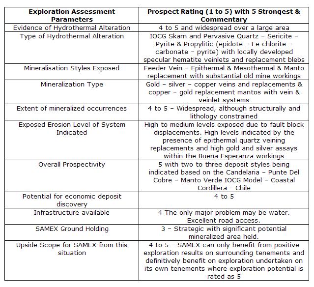

Plate 9: A view of Freeport McMoRan’s “Candeleria” open pit copper – gold (IOCG) mine near Copiapo – Region III Chile. This picture provides some idea of the target being sought within the Chimberos prospect area.
PART 2: Clive Maund's Technical Analysis of SAMEX MINING CORP.
by Clive Maund
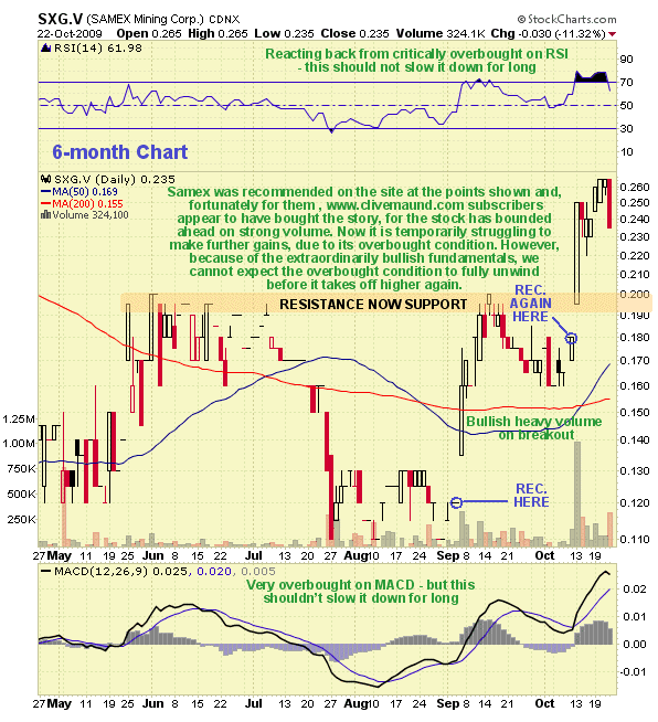
Samex Mining is a stock that is still in the earliest stages of a major bullmarket advance. On its 3-year chart we can see that it has just started to emerge from a low Flat Pan base, which formed above a clear line of support after it finally hit bottom in October last year after a severe decline. The upside volume buildup that preceded the breakout, and the heavy volume on the breakout, which have driven the On-balance Volume line up, are signs that an important uptrend is beginning. What typically happens in a situation like this is that the stock takes off like a rocket as the market gets its collective head around the sudden improvement in fortunes and outlook for the company, and after a large percentage gain stalls out and runs off sideways for many months consolidating, which gives the steadily improving fundamentals of the company "time to catch up" and justify the higher stock price. This is the dynamic that creates the common and bullish Pan & Handle base pattern. On the Samex chart we see the price starting to ascend from the completed Pan - it should now ascend rapidly, probably to the resistance level in the 50 - 60 cent area - but possibly considerably higher due to its spectacular fundamentals, before it runs off sideways probably for many months forming a "Handle" to complete the Pan & Handle base formation, giving the company time to improve its situation on the ground.

On the 6-month chart we can see recent action in more detail. Here we see where the stock was first recommended on Clive Maund due solely to the correct assessment of its technical condition. After that the writer was shown around the Los Zorros goldfield by company senior geologist Rob Kell and saw at first hand the huge potential of this prospect. This led to the second recommendation of the stock in October at the strategic point shown following a reaction, and principally on technical grounds, as price - volume action following the first recommendation had been very bullish. Then Nigel Maund arrived from Australia and in addition to visiting Los Zorros we inspected the astonishing Chimberos prospect in the company of Rob Kell and CEO Jeff Dahl, where we witnessed the neighbour's diamond drilling rigs in action close to Samex's tenements. Returning to the chart we see that following the 2nd recommendation of the stock it soared, this time on huge volume as it broke out from the Pan base, since which time it inched higher before reacting back to ease the overbought condition. While further consolidation or reaction would be helpful before the advance resumes, this is considered to be one of those rare cases where the outlook for the company is improving so rapidly - and the market's appreciation of this fact - that the stock price could continue to advance, overbought or not, with only the briefest of pauses for consolidation or minor reaction. Even in the event of a general market cave-in it is considered unlikely that the price will drop back below the new support at the 20 cent level. Thus anyone wishing to take positions in the stock should not expect to see more than a minor reaction - waiting for a larger one may involve missing it completely.
For the benefit of those who require a little guidance regarding the outlook for the stock price in the event of a major discovery being made, the following chart shows what happened to the stock price of Arequipa after it made a major discovery...

Chimberos is not the only promising prospect in Samex Mining's possession. Look out for another Special Report in due course on the wholly owned Los Zorros goldfield which is also in the same rich coastal belt in northern Chile, not far south of Freeport's giant Candelaria copper mine.
Hurricane Rick! Thank you! Hope the rest of day doesnt blow it. Lol
Either way, you are correct. The party is just getting started.
Good call Mr. GP!!! Keep in mind there are only 7 board marks right now and you and I are the only ones posting. I have a feeling that will change in short order.
Since no one ekse is in here to pat me on the back, I'll pat myself for such a good call.....pat pat pat!
Still a screaming buy.
I think there is some big money coming into SMXMF.
It has above $1.00 written all over it.
Really sweet day today, up over 11% on more than 500K (more than 5x the recent average volume). The price kept bumping its head on the .83 resistance line. This move probably got SMXMF on more people's radars today. If we have a follow through on volume tomorrow, we should bust through .83 and head for blue skies.
Volume keeps coming. Screaming buy here for higher high.
Worth a read here at the very least:
http://blogs.miis.edu/trade/2011/01/11/chinas-big-move-into-latin-america/
Lots of jostling on LII today. It had been dormant for weeks. Nice to see buying volume come in...the most we've had since December and it's only 1:00.
Volume is Key. and it is here with more coming it appears.
That it is. Nice relative volume too. If we break .83, it should run.
Looks spot on to me. I was hoping to get a few around .70 but these shares are held tight.
Annotated SMXMF chart. We're in the middle of a bullish reversal looking to break out. Resistance at .83 and then we break out. If trend continues we should break out some time within the week. Could use some more volume though. Chart looks good though.
Samex: In Search of a World Class Discovery
Adrian Douglas
Published 11/15/2010
Samex announced on Sept. 29 it had started its long-anticipated drilling campaign at several of the project areas at Los Zorros district in Chile.
On Oct. 15 the company made an eye-popping announcement it had arranged a private placement and on Nov. 3 announced the financing had successfully closed. What is so surprising is that at a time when juniors have been finding it hard to raise financing, Samex has not only secured a large $8.8 million of capital injection but has priced it at almost 40% above the stock price prior to the initial announcement. Jeff Dahl, president and CEO, said in the news release that this will allow the company to not only expand its exploration efforts but to accelerate them too. I have not seen any other junior achieve such a large financing under such favorable terms in recent years.
In the last year I have reviewed over 800 junior mining companies; while a handful have good exploration prospects, in my opinion, none come close to the potential that Samex has to discover a world class gold deposit (defined as being in excess of 5 million ounces of gold). It appears the company has attracted investors who hold a similar view.
In the January 2008 Morgan Report at www.silver-investor.com, Dave Morgan commented:
“Over many years, SAMEX has patiently accumulated an excellent group of quality gold-silver-copper exploration prospects located in some of the most prospective mineral belts in Chile and Bolivia. With the continuing strong metals markets supporting the exploration sector, the company stands out as an important contender for the next big discovery.”
The company has diligently advanced its geological field work since then which has led to a much better understanding of the geological model at Los Zorros. This is exciting to say the very least.
It is five years since the company completed its Phase 1 exploration drilling program. Many investors are not aware of the significant successes of that program. The company made two impressive gold discoveries. However, these discoveries were announced in news releases that had totally mundane headlines:
On Jan. 25, 2005, the company issued a release with the incredibly bland title of “Exploration Drilling Update - Exploration Area II - Los Zorros Property, Chile”
This release described a gold discovery of over 97 meters of 0.3 grams per tonne (g/tonne) of gold in which 4.7 meters had an impressive grade of 2.6 g/tonne of gold and 15.9 g/tonne of silver. The target A of Exploration Area II, where the discovery was made, was later identified as “Milagro”.
This was followed on April 5, 2005, with a release with the equally low key title of “Exploration Drilling Update - Exploration Area III - Los Zorros Property, Chile”
This unexciting headline gave no clue as to the outstanding high grade gold discovery announced within the news release. Drill hole DDH-N-04-05 in Target E (later to be identified as “Nora”) intersected two high-grade intervals, each having true widths of 1.53 meters, and containing gold of 35.4 g/mt (1.1 ozs per tonne) and 40.1 g/mt (1.25 ozs per tonne) respectively. These intervals were in a larger mineralized intercept that averaged 15.96 g/mt gold (1/2 oz per tonne) over a true width of 7.66 meters (25 feet).
So why didn’t Samex shout from the roof-tops about these stunningly good gold discoveries? Reading between the lines, the company was at the time involved in broader strategic land acquisition activities and most likely didn’t want to be disadvantaged in those negotiations. This notion is supported by the fact that the exploration areas were initially identified only as Exploration Areas I through VII with alphabetic letters to denote each target within the area. While Samex did successfully complete its acquisition of the targeted land positions on favorable terms the downside to this has been that many investors are unaware what outstanding gold discoveries were made in Phase 1.
In addition to the drill-hole gold discoveries, extensive surface trenching has revealed anomalous gold occurrences distributed across the property. For example, at Nora trenching yielded gold grades ranging from 0.1 g/tonne to an eye-popping 17.8 g/t.
But the most tantalizing aspect of this developing exploration story is the geological work that has been done since 2009 that has sought to understand the geological mechanisms that have been responsible for the gold deposition and that now underpin the on-going second phase of exploration.
The geological model is considered to be an analog of the Carlin Trend in Nevada. Such a hypothesis is supported by observations of geological phenomena on a large scale (regional), medium scale (district) and on a small scale (geology and mineralization).
The very nature by which Carlin-style deposits are formed infers the potential for laterally extensive mineralization and as a result the possibility of world class gold deposits.
The Carlin Trend is North America's most prolific gold-producing district and hosts the second-largest known gold resources in the world, after the Witwatersrand in South Africa. More than 100 million ounces of proven and probable reserves occur on the Carlin Trend and there may be up to 180 million ounces of resources.
Gold deposits have their origins in magmatic intrusions. In general the magmatic intrusion into a host rock creates massive fracturing of the rock. Water from an aquifer interacts with the hot magma giving rise to hydrothermal processes which percolate and concentrate mineral rich fluids. Over millions of years gold mineralization is deposited which fills the fractures and cracks in the host rock. This leads to rich gold veins that can be mined. If such deposits become exposed to the surface at high altitude then rivers and streams can erode the deposit and carry placers or fine grains of gold and deposit them in an alluvial plain or river delta.
Because the hydrothermal process deposits minerals in the cracks and fissures generated by the magmatic intrusion the mineralization is localized near to the intrusion. The Carlin-style deposition, however, is a variation on the typical hydrothermal process and requires a very particular geologic environment for it to occur. Carlin-style deposits typically have very large areal extent giving rise to multi-million ounce gold deposits.
The mechanics of a Carlin-style deposit are broadly described below and shown graphically in Figure 1. A fault or dyke is created in the earth’s crust by tectonic movement such as by strike/slip or wrench faulting. Such a fault has lateral displacement but very little vertical displacement of the fault blocks. Volcanic activity deposits an impermeable “cap rock” over the area which seals off the upper aperture of the fault. At some later stage magma squeezes into the fault. If an aquifer is present then a hydrothermal process commences and hot mineral enriched fluids percolate in the fault. If the faulted block contains a permeable layer, as pressure builds in the cap-rock sealed fault the mineral enriched fluids will flow into the permeable layer or layers. Such layers are typically quartz bearing calcitic siltstones. The hot and corrosive hydrothermal fluids dissolve the inter-granular calcite which increases the siltstone permeability and porosity while the quartz grains prevent the formation from collapsing. Over millions of years the formation is invaded with rich mineralized fluids which eventually crystallize into gold rich minerals that fill the void between the quartz grains. Unlike vein style deposits the gold is distributed throughout the rock in a micro-crystalline form and is often not visible to the naked eye and is only identified by laboratory assays.
The nature of the Carlin-style deposition means that deposits can be high grade and be volumetrically very large as has been demonstrated by the Carlin trend itself that has already produced more than 50 million ounces of gold and has underground mine grades that average more than 10 g/tonne and near surface open pit grades of more than 6 g/tonne.
Dr. Ken Snyder is a retired geologist who explored Nevada for more than 30 years and discovered the Ken Snyder (a.k.a. Midas) mine site on the Carlin Trend. He describes the Carlin-style deposition process as follows:
“it was also important to have silty quartz component siltstones as host rocks. The gold bearing fluids were slightly acidic, which dissolved the calcite and made the rocks more porous. There needed to be enough quartz within the siltstones to prevent their increased permeability from collapsing the rock. Once gold-bearing fluid came in contact with the carbonates in the rock, this changed the chemistry during the cool-down period and gold dropped out. Successive waves of gold-bearing fluids may have continually pulsed through these same rock formations over millions of years to build up gold mineralization within them”
The details of the geology at Los Zorros are too complex for an in-depth discussion in this article but I will summarize some of the key observations that justify the application of a Carlin-style geological model.
What is so unique about Los Zorros that the conditions exist there for Carlin-style gold deposits? A clue to this can be seen from the map of Chile shown in Figure 3. The circles on the map are mines. About 30% of the mines on the map fall on a very narrow north-south trend as indicated by the dashed blue line. This almost certainly implies there is a low displacement subterranean fault that is associated with this pronounced linear feature. There is no noticeable fault when looking at a Google Earth satellite map. But it should be noted that with a few small exceptions, none of the major Carlin faults or Cortez faults in Nevada are obvious from the ground or by aerial pictures or satellite reconnaissance, having been covered over by many events in relatively recent geological history, to include volcanic activity and the creation of cross rifts. I mentioned earlier that a strike/slip fault or a wrench fault covered by a cap rock is a general model for a Carlin environment.
Almost 60% of the mines in Figure 3 fall in the pink shaded area that trends NNE-SSW. This roughly corresponds to a cretaceous sedimentary-volcanic belt. This belt contains many horizons that are calcitic siltstones as well as thick overlying gabro. There is a confluence of these two geological features at Los Zorros. This represents the key macro-scale elements required for Carlin-style deposition: A buried fault overlain with volcanic cap rock and within the fault block, permeable calcitic siltstones that could have been invaded with mineral rich hydrothermal fluids. If this is the macro-level geological process that has given rise to the gold that has already been encountered at Los Zorros it would indicate that Los Zorros is ideally situated in the confluence of the regional geological features for such Carlin-style gold deposits.
The Los Zorros property is very large covering approximately 80 square kilometers. The property contains at least seven very prospective project areas any of which could potentially host world class gold discoveries.
The company is considering employing the latest state-of-the-art earth imaging technology to assist in fine tuning the exploration program. This technology is the Titan 24 developed by Quantec Geoscience. Embracing the use of such revolutionary geophysical tools certainly sets Samex apart from the majority of its peers.
The result of a four-year effort to develop advanced tools for very precise and deep subsurface information, the array-based Titan 24 Deep Earth Imaging system is the most advanced electrical earth imaging technology. The system images conductive mineralization, disseminated mineralization, alteration, structure and geology to 700 meters and beyond for reliable and cost-effective targeting of drill holes.
Measuring the parameters of DC (resistivity), IP (chargeability) and MT (magnetotelluric resistivity), Titan 24 measures to depths of 750 meters with IP and can explore beyond 1.5 kilometers with MT data. The depth of investigation coupled with the multi-parameter data make the system the best option available for obtaining subsurface pre-drilling information related to geologic structure and for the direct detection of mineral deposits.
Without a doubt the current drilling program at Los Zorros is what many long time Samex investors have been waiting for. The high-grade gold discoveries that were encountered over large intercepts in the phase 1 drilling campaign and the high-anomalous gold occurrences in surface trenching along with substantial geological field work have culminated in a Carlin-style geological model being postulated as the best description of the Los Zorros geology. If the model is substantiated by drill testing then the implications are that the gold discoveries already encountered could be part of a very big gold deposit or multiple deposits like the clustered gold deposits in the Carlin district.
In addition the company in a January 21, 2010, news release already outlined the potential for the Cinchado project that was not part of the Phase 1 exploration. It is, however, the first project being tested in the current drilling program. The information can be extrapolated to infer a target that could potentially host 3-4 million ounces of gold.
There are no guarantees in exploration but a junior that has such large prospective properties hosting multiple targets, having already made significant gold discoveries, having properties in a mining friendly country such as Chile, having a well experienced and knowledgeable exploration team headed up by someone of the caliber and track record of Rob Kell (vice president ofeExploration) certainly shortens the odds.
Samex has recently trading at approximately $0.50 on the TSX (SXG.V) and on the US Bulletin Board (SMXMF.OB). This puts its market capitalization at less than 50 million dollars. Considering that would indicate that Samex is undervalued and if the Phase 1 gold discoveries can be added to and extended, Samex could enjoy outstanding price appreciation in the very near future.
I don’t know of another junior mining company that has acquired 100% ownership of a district-sized property that incorporates multiple projects that each have the potential to host world class gold discoveries, is located close to a major highway and power lines and is in a mining friendly jurisdiction. The world-wide average for gold grade in producing mines is just two grams/tonne. It is, therefore, rare for a junior explorer to successfully hit good intercepts that contain gold mineralization in excess of one ounce of gold per tonne (32 grams/tonne) let alone achieve it in Phase 1 of exploration drilling.
Even if a junior has such phenomenal potential, the major obstacle to success is very often a lack of funds to prove up a discovery. Samex with its latest substantial private placement has resolved that problem and in doing so has shown a clean pair of heels to its peers by securing it at almost 40% above recent average market price which is no doubt being lauded by its shareholders.
Taken altogether Samex provides an extraordinary opportunity for speculative investors.
Samex: In Search of a World Class Discovery
Yes....i'm serious.
SMXMF has formed my now famous Flying
Dragon chart pattern. Very Bullish.
BUYINS.NET, http://www.buyins.net, a leading provider of Regulation SHO compliance monitoring, short sale trading statistics and market integrity surveillance, has updated coverage on SAMEX MINING (OTCBB:SMXMF) after releasing the latest short sale data through September 3, 2010. The total aggregate number of shares shorted since August 2009 is approximately 6.14 million shares. An average of 27.69% of daily volume is short selling. The SqueezeTrigger price for all (OTCBB:SMXMF) shares shorted is $0.32. A short squeeze is expected to begin when SMXMF closes above $0.32.
SAMEX Mining Corp.: "Los Zorros Gold Property Overview" Video-Gram
ABBOTSFORD, BRITISH COLUMBIA, Sep. 18, 2009 (Marketwire) -- A new video-gram entitled "Los Zorros Gold Property Overview" has been added to the SAMEX (TSX VENTURE:SXG)(OTCBB:SMXMF) website at www.samex.com. The video-gram utilizes maps, photographs and graphics to provide a brief overview of the Company's Los Zorros property in Chile.
The Los Zorros Property covers approximately 80 square kilometers of an old mining district of numerous small, gold, silver and copper mines and showings. This single property holding hosts a number of highly prospective project areas such as the "Nora Project", the "Cinchado Project", the "Milagro Pampa Project" and the "Milagro Project" that are being explored for gold deposits by SAMEX. Each of these targets represent an important separate project area for SAMEX. In addition, numerous other mineralized areas, which have yet to be rigorously investigated and explored, have also been identified within the property position and in close vicinity to these major gold targets. The "Los Zorros Gold Property Overview" video-gram is designed to acquaint the viewer with the location of various prospective areas within the property.
A common exploration strategy is to explore for new mineral deposits in areas where minerals have previously been found or mined and it's not unusual for numerous ore deposits to be clustered in districts or along trends. With these concepts in mind, SAMEX is exploring for multiple precious metal deposits that may be clustered beneath the widespread gold, silver and copper occurrences in this old mining district.
Information in the "Los Zorros Gold Property Overview" video-gram is summary in nature and should be considered together with more detailed documents and information upon which it is based that can be viewed in the Company's publicly filed documents at www.sedar.com and the SAMEX website at www.samex.com.
Jeffrey Dahl, President
The TSX Venture Exchange has neither approved nor disapproved of the information contained herein.
Source: Marketwire Canada (September 18, 2009 - 3:19 PM EDT)
News by QuoteMedia
i'm holding until gold goes over $1,000/oz
|
Followers
|
8
|
Posters
|
|
|
Posts (Today)
|
0
|
Posts (Total)
|
69
|
|
Created
|
03/17/04
|
Type
|
Free
|
| Moderators | |||

SMXMF on US OTC Market: http://www.otcmarkets.com/stock/SMXMF/quote
SXG on the Toronto Stock Exchange http://www.tsx.com/en/
Website: http://www.samex.com/
news http://www.samex.com/news/News.html
financials http://www.samex.com/financials/financials.htm
coreshack http://www.samex.com/Coreshack/corehome.htm
request info http://www.samex.com/request_info.htm
tour a quick profile http://www.samex.com/tour/quick_profile.htm
122,285,219 Outstanding Shares as of March 31, 2011
SAMEX - A Close-Up View of the Prospects by Adrian Douglas (2008)
SAMEX - The Elephant Hunters by Adrian Douglas (2006)
SAMEX PROPERTIES

LOS ZORROS PROPERTY, CHILE
The Los Zorros Property in the Atacama region of northern Chile is located approximately 60 kilometers south of the city of Copiapo, Chile. Although gold is the primary focus of SAMEX's exploration at Los Zorros, important values of silver and copper are also present in certain target areas. The Los Zorros property holding consists of multiple project areas that cover approximately 80 square kilometers within a district of scattered numerous small mines and prospects where there was sporadic attempts at small-scale production for gold and copper-silver in the past. The Company's Chilean subsidiary, Minera Samex Chile, S.A., has mineral rights to 65 exploitation mining concessions that cover an area of approximately 7,782 hectares that comprise the Los Zorros property in Chile. The Company acquired the concessions by a combination of staking and acquisition through government auctions (approximately 6,049 hectares), a purchase agreement (1,429 hectares), and by the exercise of two purchase option contracts (209 hectares and 95 hectares). Metal-laden hydrothermal fluids thought to be derived from the younger porphyritic intrusions, likely expelled out along fault structure pathways and into favorable sedimentary intervals to form the significant gold and copper-silver mineralized areas of Cinchado, Nora, Milagro, and Milagro Pampa. There are also many outlying mineral occurrences at Los Zorros yet to be systematically explored by SAMEX including: La Florida and Lora (gold and copper-gold), Virgen de Carmen and Colorina (copper-silver; possible deeper-seated gold and copper-gold), and Salvadora and Cresta de Gallo (barite vein systems with possible deeper-seated gold and copper-gold).

The Los Zorros property contains numerous large-sized gold, silver and copper targets on a single property holding and thus represents a very important, strategic opportunity for SAMEX. The property is geologically well-situated within the highly prospective mining belt that contains the copper-gold ore bodies of the Punta del Cobre District (150 million cumulative tonnes with an average grade of 1.5% copper, 0.2 to 0.6 g/mt gold, 2 - 8 g/t silver), the large Candelaria mine (460 million tonnes containing 0.82% copper, 0.22 g/mt gold, 3.1 g/mt silver), the large, mined-out Chanarcillo silver deposit (+100 million ounces of silver), plus many smaller copper-gold and gold ore bodies which still locally support mining operations. Infrastructure for large mining activity is readily available in the area with power, transportation, water, communications and manpower all within advantageously close distances. Because of the large size of the property, and the fact that our exploration is still in progress, the information and ideas behind the targets currently being developed must be considered as an evolving picture. The possibility of defining further new targets and project areas on the property remains strong.
What has been revealed geologically at Los Zorros has provided SAMEX with strong impetus to explore for multiple precious metal deposits that may be clustered beneath the widespread precious metal occurrences in this little-explored district of historic small mining activity.
During 2004, we completed 8,617 meters of diamond core drilling in 26 holes, 10,800 meters of bulldozer trenching in 65 trenches and more than 3,100 trench and surface samples/assays; and an additional 1,865 meters of trenching (10 trenches/559 samples) during 2005. With the Company's land position now satisfactorily expanded, the Company is using the historic names of the various mines and landmarks to identify the various project areas.
| Old Project Area | New (Historic) Property Name | Commodity | Phase I (2004-2005) Results |
| Exploration Area I | Lora | Copper, Gold, Moly | |
| | Lora S.E. | | |
| Exploration Area II | Milagro | Gold, Silver | DDH-ML-04-01 with 2.579 g/mt gold over 4.4 meters true width |
| | Milagro Pampa | Gold, Silver, Copper | |
| | Florida | | |
| | West Florida | Gold | Trench TMW-10 with .405 g/mt gold over 138 meters |
| Exploration III | Nora | Gold | DDH-N-04-05 with 15.96 g/mt gold over 7.66 meter; Trench TN-9 with 0.757 g/mt gold over 131 meters; Trench TN-3 with 0.558 g/mt gold over 117 meters |
| Exploration IV | Cinchado | Gold, Silver, Copper | Values ranging from 0.05 to 9.5 g/mt gold in 151 rock-chip samples of breccia in the open-cut of the old San Pedro mine |
| Exploration V | Salvadora | Gold, Silver, Copper | |
| Exploration VI | Colorina | Gold, Silver, Copper | |
| Exploration VII | Virgen del Carmen | Gold, Silver, Copper |
Our first phase exploration, trenching and drilling during 2004 and 2005 was conducted in the Nora, Milagro, and Lora areas, which are only a portion of the project areas at the Los Zorros property. SAMEX resumed exploration at the Los Zorros Property in 2009. The encouraging results from phase I exploration, trenching and drilling during 2004-2005 provide important guides for our current exploration that is focused on designing future exploration drilling programs for these areas. As described below, the Los Zorros property contains numerous significant project areas on a single property holding and thus represents a very important, strategic opportunity for SAMEX. The Cinchado, Colorina, Virgin del Carmen, and Salvadora areas at Los Zorros have yet to be explored by drilling. The Milagro, Nora, Cinchado and Milagro Pampa projects are being simultaneously advanced and prepared for a drilling program to test multiple large gold targets for Carlin-style ore bodies. A "Milagro Gold Project" graphics plate with map-views, cross-section and photos has been posted on the SAMEX website at www.samex.com for viewing in conjunction with this summary information.
CINCHADO
Our exploration work at the Los Zorros Property during 2009 identified a significant Carlin-type breccia- and sediment-hosted gold exploration target in the Cinchado Project area. The target is positioned in a large down-faulted structural block adjacent to an up-thrown fault block containing a wedge-shaped breccia body. This 40-meter thick breccia was historically exploited for gold on a small scale at the San Pedro mine. Detailed exploration work by SAMEX indicates that the gold mineralized breccia of the San Pedro mine may be a small, faulted-off portion of a more extensive breccia body beneath the Cerro (Mt.) Cinchado area.
The San Pedro Mine is situated at the south end of Cerro Cinchado, a prominent, isolated mountain. A review of the results of numerous surface, underground chip and bulk samples taken by the previous owner during underground mining activities between 1979 and 1987, and before the onset of open-cut mining, show historical gold grades in the breccia ranging from 0.2 to 37 grams/tonne with an average grade of around 3.2 grams/tonne. A former mine operator who conducted open cut mining of the breccia from 1991 to 1993 also reported an average grade of just over 3 grams/tonne. These historic results have not been verified by SAMEX. However, continuous rock-chip sampling by SAMEX of breccia exposures left around the pit walls (71 samples) gave an average gold content of 1.905 g/mt and a range of gold values of 0.037 to 9.5 grams/tonne with 38 of the samples (53%) containing greater than 1 gram/tonne gold.
The breccia of the San Pedro mine is composed of clasts including jasperoid silica, altered calcareous siltstone, skarn, several igneous rock types, limestone, and breccia. The gold-mineralized breccia body is a nearly flat to gently dipping wedge-shaped body which can be traced out eastward to distal parts with negligible gold content, but containing a characteristic suite of anomalous Cu, Ag, Zn and anomalous pathfinder metals (As, Sb, Hg) with much coarse-bladed barite deposition.
Of particular importance, geologic mapping has found that these same distal features (including a zone of breccia/brecciated limestone in-filled with abundant coarse-bladed barite, jasperoid mantos layers, jasperoid (+/-barite) veins/veinlets with 40 anomalous copper and pathfinder metal content) can be traced in outcrop in continuous fashion for 1,200 meters semi-circular distance around the entire east and north sides of Cerro Cinchado (the down-faulted block). The evidence in these distal outcrops provides significant credence for the gold exploration target defined at Cinchado. Jeffrey Dahl, President and CEO remarked, "The San Pedro breccia and these distal breccia outcrops could be the flared-out edge to a large, central, mineralized breccia beneath the dome-shaped Cerro Cinchado - this may be just the tip of the iceberg. If our exploration confirms this model, it could have a very positive impact on the Company."
NORA - High Grade Gold Target
Nora is a large area hosting a complex swarm of numerous copper-gold-mineralized barite veins and a series of broad zones of anomalous gold we exposed by trenching. The upper oxide parts of some principal veins of the swarm have been mined historically on a small scale for gold, copper and barite. Exploration work we carried out at Nora during 2004 included: geologic mapping and surface outcrop rock-chip sampling mostly across principal vein structures (193 samples), approximately 2,000 meters of trenching (14 trenches/520 channel samples), and 3,799.5 meters of core drilling in 10 holes, and during 2005, an additional 1,865 meters of trenching (10 trenches/559 samples).
During phase I drilling at Nora, an impressive, mantos-style (layered), high-grade gold intersection (15.96 g/mt gold over 7.66 meters or 0.51 oz/mt over 25.12 ft.) was made in drill hole DDH-04-05. The intersected gold mineralization occurs in a complicated package of volcaniclastic detrital rocks, volcanic breccia, and minor siliclastic sedimentary rocks. The highest grades of gold occur within a distinctly layered clastic sequence and specifically within two, closely spaced, unique black-matrix breccia sub-intervals which have been silicified and contain abundant disseminated pyrite and minor chalcopyrite. A 250-meter wide alteration halo surrounds the gold mineralized interval and consists of a narrow outer chloritic zone and thick interior zone of silica-clay-pyrite with scattered veinlets of quartz-pyrite+/-chalcopyrite. Coincident with the alteration halo are numerous anomalous to highly anomalous values of copper, mercury, and silver and many elevated (>25 ppb to <100 ppb range) to anomalous (>100 ppb range) gold values. This alteration and geochemical expression suggests strong and widespread mineralizing processes were associated with the deposition of the gold-rich interval.
Importantly, the high-grade, gold-mineralized interval is possibly widespread beneath the NORA area. The substantial width of the haloes of both the associated hydrothermal alteration and anomalous values of copper, mercury, and silver, plus elevated to anomalous gold surrounding the gold-mineralized interval in DDH-N-04-05, indicate a strong mineralizing system that could have produced an extensive gold ore body of moderate- to high-grade nature. This may be supported by the presence at the surface, of numerous copper-gold-mineralized barite veins and a series of north-trending broad zones of anomalous gold exposed by trenching which may be leakage up from the deeper seated, high-grade, gold-mineralized mantos. These anomalous gold zones may prove to comprise an important guide to deeper seated high-grade gold mineralization. The area of veins and anomalous gold zones measures 1,200 meters by 1,000 meters and if the gold-rich mantos layer extends beneath much of this prospective area, a large target could be present. This target potential is conceptual in nature, there has been insufficient exploration to define a mineral resource at Nora and it is uncertain if further exploration will result in discovery of a mineral resource within the NORA area.
MILAGRO
Milagro is an area where gold was previously mined on a small scale at the Milagro Mine via open cut methods. The gold mineralization within the small local mine workings occurs with distinct clay alteration and silicification and may be muchmore extensive beneath surrounding areas to the previous mining activity. PIMA analyses of altered tuff samples from the mine area show mineral assemblages typical of high-level epithermal gold-mineralized systems (opaline, silica, silica-jarosite, alunitehalloysite-montmorillonite, smectite-kaolinite, serecite-pyrophyllite, illite-silica, gypsum-silica and jarosite silica).
During recent exploration during the first quarter of 2010 in the Milagro Project area, an elongate outcrop of jasperoid/silica breccia was sampled and returned precious metal values ranging from 0.39 to 2.01 grams/tonne gold and 3.1 to 28 grams/tonne silver (eight chip samples, each across approx. 0.5 meters). The discovery of this Carlin-style jasperoid/silica breccia occurrence may have positive implications for the overall extent and target size of the Milagro Project area, where our phase I drill hole ML-04-01 encountered 97.3 meters averaging 0.302 g/t gold, including 2.579 g/t gold over 4.7 meters (previously reported in 2005).
Importantly, the outcropping gold-bearing leakage features provide strong credence to extend the area previously considered prospective at the Milagro Project, an additional kilometer to the southeast. The target implications will be incorporated into the ongoing exploration program and be reported on in greater detail in the future.
At the Milagro Project, a dense gabbro sill caps gold mantos layers and a +/-90-meter-thick underlying breccia, which also contains highly anomalous gold. The capping gabbro sill appears to have acted as a barrier to ascending mineralizing fluids, which then pooled and spread out beneath it in favorable stratigraphic intervals producing gold-mineralized mantos and a thick breccia layer. The gabbro and underlying thick gold-mineralized package of mantos and breccia are open down-dip in a southeast direction and have not yet been drill tested.
At the northwest end of the project area one of the gold-mineralized mantos layers is exposed in shallow open cuts at the historic Milagro mine. Earlier phase I exploration drilling was limited to only two core holes near the Milagro mine to initially determine the character and geologic features of the gold mineralization. It is highly encouraging to observe Carlin-style precious metal mineralized jasperoid/silica breccia in outcrop more than a kilometer away to the southeast. It demonstrates that mineralizing fluids leaked upwards along fault-controlled pathways through the capping gabbro and suggests the area of gold mineralization beneath the gabbro may be more extensive.
Similar Carlin-style gold mineralization and alteration features have also been observed at the neighbouring Nora and Cinchado Project areas of the Los Zorros Property. Importantly, SAMEX's exploration work at the Los Zorros property has corroborated many geologic features as being analogous to the Carlin Trend district in Nevada. These observations and results have significant implications for target models and exploration programs going forward. Geologic fieldwork, in part is focused on finding and mapping the distribution of these leakage features to help guide future exploration drilling efforts.
MILAGRO PAMPA
The Milagro Pampa area hosts a stockwork-veined, sericite-clay-quartz-altered/pyritized gabbro sill with strongly anomalous copper-gold-silver and mercury content which is concealed beneath pampa cover and was discovered during Phase I drilling in hole ML-04-03. The strong alteration, anhydrite and quartz-pyrite stockwork veining, and highly anomalous copper content intersected suggests that Milagro Pampa is near the center of the intrusive porphyry source of the mineralizing system. The hole did not quite reach and penetrate through the floor of an altered and mineralized gabbro body, but garnet skarn xenolith blocks comprising the last twenty meters suggest that the hole was stopped near the floor contact with underlying rock. The strong alteration, pyritization and variable anomalous copper over the entire length of the hole may comprise the outer halo to substantial gold-copper mineralization hosted in altered porphyry and layered skarnoid sedimentary and volcaniclastic rocks that likely underlie the gabbro body.
In light of the gold mineralization being concentrated just below the floor of the gabbro unit at the Milagro Mine, exploration results make a strong case to test for copper-gold mineralization underlying the gabbro in the Milagro Pampa area. The fault bounded prospective area of Milagro Pampa measures 1000 meters by 500 meters with the top of the target becoming progressively deeper in a down-dip direction to the east (ranging approximately 400 to 500 meters vertical depth).
FLORIDA
To the east of West Florida target lies the Florida target. Phase 1 drilling of four holes F1, F2, ML6, and ML7 revealed a sequence of sedimentary rocks overlying a sequence of evaporite (gypsum-anhydrite) rocks. The underlying sequence including the lower part of the anhydrite unit is replaced by variable amounts of banded massive pyrite and specular hematite. The altered packages of sedimentary rock below and above the gypsum-anhydrite unit were found to contain anomalous amounts of silver, copper, mercury, and arsenic. Upper and lower subintervals of anomalous gold importantly also occur within the altered sedimentary rock packages. The geological setting of reactive calcareous sedimentary rocks, the character of the alteration (silicification) and the geochemical signature of prominently anomalous amounts of pathfinder metals: mercury and arsenic suggest that the intersected thick mantos interval could be the more-distal, low-grade part to a large epithermal gold-silver deposit. Drilling a series of vertical holes spaced at 150 meters apart will be required during a phase-two drill program to determine if there is a gradient of improving gold and silver grades which can be followed into a discovery.
WEST FLORIDA
West Florida is an area where Phase I trenching and sampling exposed silicified and clay-altered quartz-eye porphyritic intrusion with significantly anomalous gold content including a 138-meter interval averaging 0.405 g/mt. The gold mineralized/altered intrusion intrudes up through a little-altered, thick diorite sill and coincides with a well-defined gravity low. The surface outcropping, oval-shaped area of gold mineralized quartz-eye porphyritic dacite intrusion encompasses approximately 200 meters wide by 400 meters long. Similar altered/mineralized porphyritic intrusion outcrops/daylights elsewhere in the vicinity, indicating the target extends over a much greater distance beneath the surrounding area.
LORA
The Lora project at Los Zorros is situated in an area of pampa and low-lying hills with numerous prospected showings of fault-hosted, fracture-controlled and veinleted, oxide-copper mineralization. Bulldozer trenching exposed a large copper-gold-molybdenum
anomaly within variably leached rocks over an area measuring approximately 1,000-meters long and 800-meters wide (open-ended to the east) with anomalous copper (>250 ppm), gold (>100 ppb) and elevated molybdenum (>10 ppm) in trench (see table below) and outcrop samples.
The geologic setting of this target has been disclosed by trenching to be porphyritic diorite and quartz diorite which has been strongly hypogene altered (clay-silica and sericite-pyrite) and cut by later igneous dikes. Strong supergene effects have produced secondary clays plus iron-oxide and oxide-copper minerals. The oxide-copper mineralization occurs in all rock types mostly as copper wad and chysocolla along abundant fractures, structurally controlled wide zones of multiple orientation, and as strong disseminations in altered diorite. The original copper mineralization appears likely to have been comprised of goldbearing, copper sulfide (chalcopyrite) associated with the hypogene alteration within the porphyritic dioritic rocks.
During our phase-one drilling program in 2004, six core drill holes tested only a portion of the porphyry intrusions, encountering long intervals of low-grade copper/gold mineralization in each hole. Drilling was principally along a 500-meter-long fence of four inclined holes (P1, P2, P3, P4) which were spaced on an east-west line, systematically testing across the central part of the large copper/gold anomaly defined earlier by trenching. Two additional inclined holes (P5 and P6) were drilled 200-meters southwest, and 400-meters south of the fence, respectively. Evaluation of the drill data suggests that this mineralization may represent the low-grade, distal zone or outer halo to more intensely altered and better mineralized parts of the porphyry copper/gold system within the Lora area. Further exploration is required in the Lora area to search for higher grade oxide and secondary sulfide mineralization which may be advantageously positioned at shallow depths and for proto-ore zones of combined high copper/gold grade with significant width.
COLORINA
Colorina is an area of strong hydrothermal alteration with geochemical values of gold, silver and copper that are characteristic of the high-level part, or outer halo, of a possible deeper seated epithermal, precious metal system. A unique feature of the alteration found in the Colorina area is its unusually high sodium enrichment which is similarly reported to occur associated with the large copper/gold deposits of the Candelaria and Punta del Cobre District situated 40 kilometers north of Los Zorros. The area of alteration is hosted in a thick diorite sill and measures 1500-meters (north-south) by 400- to 800-meters across (east-west). The center of the alteration is just outboard in low-lying pampa to the west of a higher, range-front mine where barite breccia and mantos-hosted oxide-copper-silver mineralization was exploited on a small scale. The alteration is characterized by hematite-clay-silica with later fracture-controlled superimposed clay-silica. This style of alteration and weakly anomalous gold, silver, copper suggests a position above perhaps deeper seated, gold-copper-silver (Candelaria-type), or goldsilver (Andacollo-type) mantos- and related vein zone-hosted mineralization similar to other ore bodies in this lower Cretaceous geologic belt.
Initial reconnaissance chip sampling (44 samples) of scattered outcrops of clay-red hematite altered and silicified porphyry and diorite in the area showed common elevated (0.022 to 0.082 ppm) levels of gold with anomalous silver (1 to 6.1 ppm). Eight samples contained weakly to moderately anomalous gold values (0.173 to 1.22 ppm) with anomalous silver (1.9 to 8.4 ppm), and mercury (110 to 1180 ppb). Higher gold values (two samples, 4.73 ppm and 5.19 ppm) are restricted to a meter-wide, oxide copper-mineralized (to 3.04% copper) northeast-trending structure. High sodium values (most >3%) and strongly depleted calcium (most <0.5%) and magnesium (most <0.2%) in the samples suggest the colorful alteration includes a peculiar sodic metasomatism which is noted to importantly occur associated with the copper-gold deposits at Punta del Cobre and Candelaria located in this same geologic belt. Also in this area, barite-bearing mantos-hosted and breccia-hosted silver and oxide-copper mineralization to several meters thick occurs, replacing a limestone unit just above the zone of altered porphyritic rock. Samples across the mantos and breccia are polymetallic in character containing anomalous copper (0.32% to 1.06%), silver (11.1 to 49.3 ppm), and zinc (1365 ppm to 9230 ppm). Detectible elevated gold values (0.011 to 0.055 ppm) are also present with markedly anomalous amounts of arsenic (2490 ppm to 2560 ppm), mercury (260 to 950 ppb), and antimony (112 to 304 ppm). An intensive program of detailed sampling and trenching has not yet been conducted. However, spot, outcrop chip sampling was extended northward, and a channel cut was taken along a 300-meter-long reconnaissance trench, located 400 meters north of the core area. This east-west oriented bulldozer trench exposed numerous altered zones with widths from a meter to over 50 meters which are separated by intervals of weakly altered to unaltered diorite. Continuous sampling along the trench wall was carried out at 5-meter-long intervals across all rock types. The geochemical analytical results from this trench and other samples within the target area show the common presence of elevated to anomalous gold and silver, high amounts of sodium, and many samples also contain low-level anomalous copper and mercury.
VIRGEN DEL CARMEN
The Virgin del Carmen area is situated along the same range front as the Colorina area and includes an area of previous small mining of oxide-copper-silver-mineralized mantos and breccia which is similar to that exploited at the small mine in the Colorina area. Additional exploration is required to further evaluate the outlying pampa to the west of the Virgen del Carmen mine for alteration/geochemical indications of a target of deeper seated, epithermal, gold-silver-copper
mineralization.
SALVADORA
The Salvadora area is a barite vein system hosted in andesite and volcaniclastic rocks. The system is +700 meters long and nearly 300 meters wide. Historic barite mining activity to shallow depths (+/- 15 meters) focused on steepdipping veins that averaged a meter in width. Barite is commonly associated with gold, silver and gold-silver deposits in epithermal environments. This area requires drilling to test the down-dip character of the veins for possible gold, silver, and copper content. The presence of complicated minor veining locally in outcrops suggests potential for a bulk-tonnage target comprised of spaced major veins with intervening rocks containing abundant minor veins/veinlets.
INCA PROPERTY, CHILE
The INCA property in the Atacama region of Chile is located approximately 90 kilometers north of the city of Copiapo, Chile and 6.0 kilometers east of the paved highway that connects Copiapo to Diego Del Amargo and the El Salvador Mine. The INCA property and the Company's exploration camp are located about 6 kilometers east of the village of Inca de Oro along a government maintained gravel road leading to the San Pedro de Cachiyuyo district. The INCA property is favorably situated from both a geological and a logistical perspective, being close to important transportation routes, power lines and general mining infrastructure.
Historically, the INCA project area has been the center of small mining activity primarily for production of oxide-copper and some secondary enriched copper sulfide ores. This area hosts variably sized breccia pipes with outcropping, or historically mined copper, molybdenum and gold mineralization and the exploration objective has been to search beneath and around this area for substantial deposits of copper with important gold, silver and molybdenum credits.
During 2006 we completed the construction and equipping of a camp and exploration office at the INCA project and compiled extensive maps of the project area. We also conducted more than 30 line-kilometers of IP geophysical survey over six survey lines. In 2007 we conducted additional geophysical surveys and a program of bulldozer trenching, sampling and assaying was completed. Blasting and bulldozer work was conducted to prepare access roads and drill pads for a Phase I core drilling program. The core-drilling program completed 10,309 meters of drilling in 35 holes, with an average hole length of approximately 300 meters. Generally the program was designed to test shallow targets proximal to existing historic mine workings and coincident with IP geophysical anomalies, for areas of stock-work veining, breccia bodies, and disseminated and/or porphyry style copper-gold-molybdenum mineralization. More specifically the program was set up to test, in systematic fashion, two principal target zones including: the Delirio-Tucumana breccia complex (14 holes) and the Puntilla-San Antonio vein system with a coincident strong IP expression (8 holes). Other target areas received more cursory drilling attention and these include: San Antonio-Providencia (7 holes), Magallanes (2 holes), Manto Cuba-San Pedro (2 holes) and Jardinera (2 holes).
The size and shape of the Providencia mine breccia pipe is not fully exposed by mining and could be over 80 meters across. The pipe is well mineralized with chalcopyrite and abundant accessory pyrite; our initial rock chip-channel samples in the mined areas were taken as a series of both vertical and several horizontal oriented lines. The copper (total) grade of initial chip-channel sampling (25 samples) shows a range via mine level of 1.24% to 2.94% copper with an overall average of 2.16% copper. The presence of strong sericite alteration, anomalous amounts of silver, lead, zinc, and antimony and position of the roof indicate that this level is at the top of the pipe and that very little of the pipe has actually been mined out. A target size of over 10 million metric tonnes is tentatively outlined for this mine-exposed breccia pipe.
The Providencia mine breccia pipe has a distinct IP signature and occurs within what appears to be a cluster of additional concealed, possibly well-mineralized breccia pipes with similar or stronger IP responses, which were disclosed by our regional IP survey. The Providencia breccia cluster is a highly prospective area 1600 meters long by 500 meters across - with several separate IP targets for copper-molybdenum-gold mineralization hosted by sulfide-bearing breccia pipes/elongate tapered bodies and perhaps out into surrounding veinleted zones. One set of our exploration core drill tests on one of the IP anomalies discovered a concealed, faulted part of a breccia pipe (Providencia West) with indications that it contains significant copper and molybdenum mineralization and anomalous silver, lead, and zinc content. This breccia pipe is positioned 700 meters to the west of the Providencia mine where an outcropping sheeted vein swarm with oxide-copper mineralization and tourmalinized/silicified pods of breccia are present over a large area in the monzonite cap above the pipe. Additional drilling is required in the Providencia area to test for other concealed breccia pipes with the objective of discovering multiple ore bodies and the potential deeper source from which these pipes have emanated.
The Company plans to conduct additional meetings and property tours with interested parties in its continuing efforts to arrange a joint venture or sale of all or a portion of the INCA property. Of note, several kilometers to the west, Chilean miner, Codelco, is planning to advance the development of their Inca de Oro ore body, which could serve to further enhance the value of our prospects.
==============================================
| Volume | |
| Day Range: | |
| Bid Price | |
| Ask Price | |
| Last Trade Time: |


