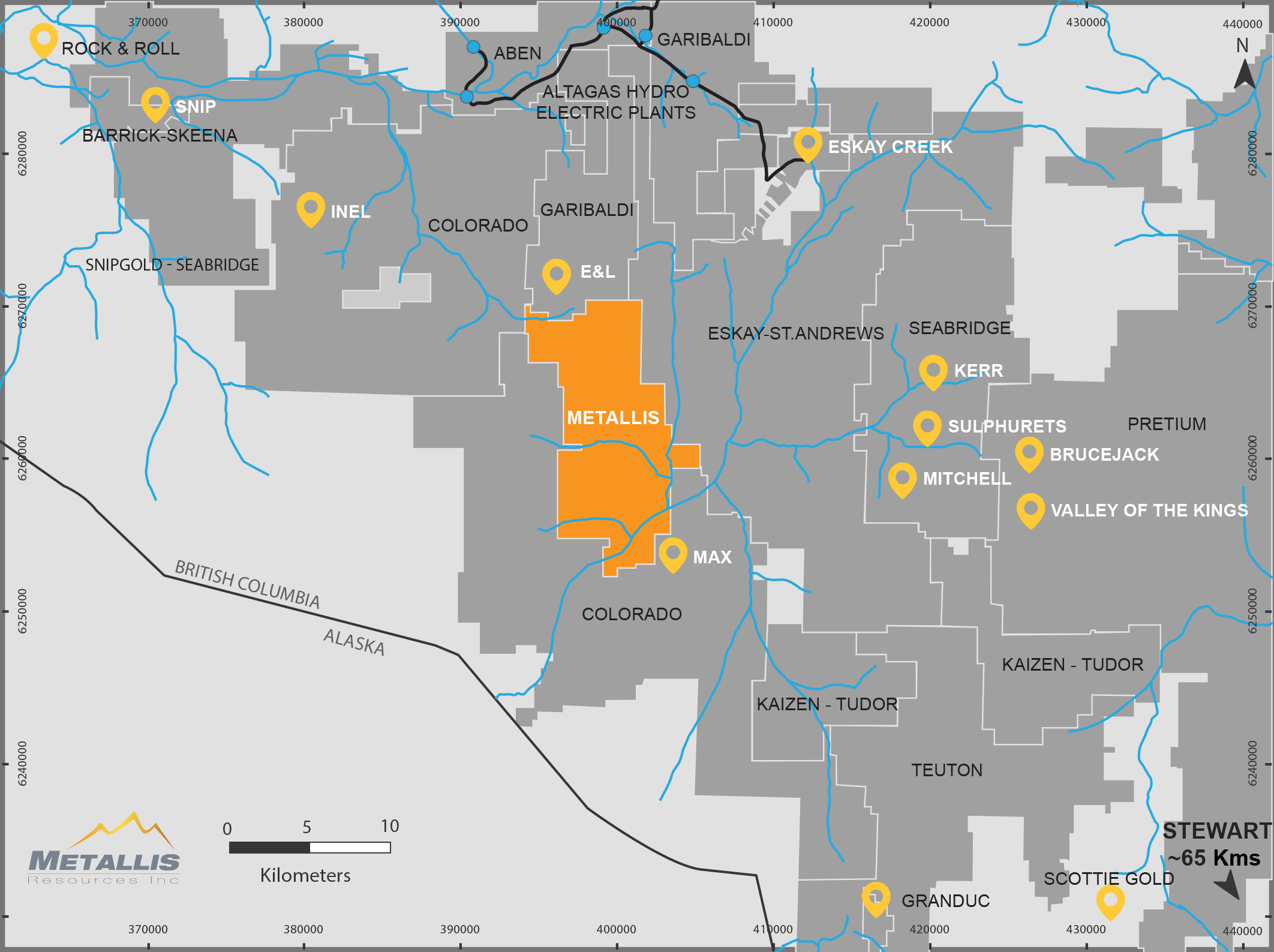
The Unuk River area has attracted prospectors, geologists and entrepreneurs in search of mineral deposits since 1893 (Grove, 1986). The earliest reported work around Kirkham property was in 1929, when “two claims [were] located, carrying free gold on the surface to the amount of $10 to the ton” (17 g/tonne) on Glacier (Fewright) Creek (BCDM Annual Report, 1929, p. C112). Exploration of the area has been concentrated in a few waves including
Initial exploration of accessible areas in the 1920s and 1930s, on foot or float planes out of Stewart.
Helicopter gossan reconnaissance in the 1950s and 1960s.
Porphyry copper exploration in the 1970s.
Gold exploration in the early 1980s and opening of Snip and Eskay Creek mines in the early 1990s.
Significant Exploration Work and Results
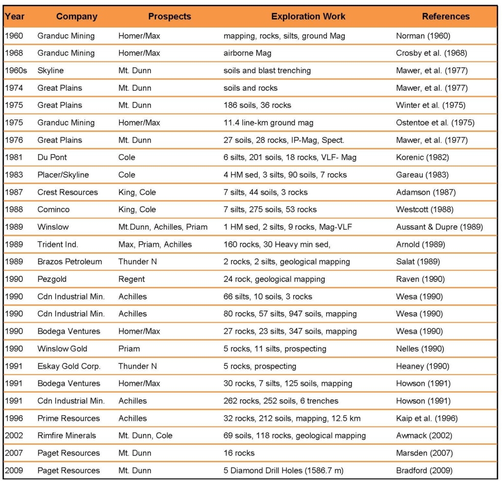
Airborne magnetic survey in 1959 led to delineation of the Max iron (-copper-cobalt) deposit with an historic, non-compliant resource of 11.2 million tonnes grading 45% Fe (Minfile, 2013)
Great Plains Development Company in 1975 and 1976, collected soil and rock chip samples between King and Fewright Creeks. The sampling defined a semi-continuous 200-300 m wide Cu-Mo soil anomaly (>180 ppm Cu, >7 ppm Mo) and 2 rock chip samples yielded 0.60% Cu and 1.28 g/t Au. The reconnaissance silt and soil samples were followed up with a soil/VLF/magnetics grid over the Cole prospect on the ridge-top between King and Terwilligen Creeks.
Du Pont’s geochemical sampling 1981 showed a 100 x 600 m north-south Cu-Au soil anomaly (>250 ppm Cu, >100 ppb Au) which was then extended further 700 m to the south and remained open to the north and south. Although a massive pyrite boulder was discovered in the Gossan Creek, which returned 7.1 g/t Au, but no significant mineralization reported in the outcrops (Korenic, 1982).
Placer/Skyline’s in 1983 work on the Cole prospect revealed elevated Au, Ag, As, Zn in isolated soils 500 m west of Cole Lake (Gareau, 1983).
Cominco in 1988 reported massive pyrite lenses along the gossan creek (Adam Fault) that returned up to 9.5 g/t Au and veinlets within argillaceous siltstone in the vicinity of the fault (Westcott, 1988). Winslow Gold Corp., in late 1988 commissioned an airborne geophysical survey which extended north as far as King Creek and covered the Mt. Dunn prospect (Dvorak, 1989b). Mapping, prospecting and geochemical sampling in following year identified altered and mineralized “quartz diorite” (monzonite) south almost to Fewright Creek (Aussant and Dupre, 1989c).
Corptech Industries Inc. in 1989 carried out a helicopter-borne VLF/magnetic survey over King and Consoat claims. They confirmed the Great Plains’ Cu-Mo soil geochemical anomaly and revealed a coincident, but slightly narrower, >100 ppb Au soil anomaly. Limited IP lines across the Evan and Cole prospects indicated two zones of high chargeability (>20 ms) near the eastern and western limits of the lines. Corptech drilled three test holes (364 m) and intersected pyritic and silicified monzonite carrying average 604 ppb Au over 14.5 m (Chapman and Dewonck, 1989; Chapman et al., 1989; Chapman et al., 1990).
The exploration work from 1991-1991 by Canadian Industrial Minerals Corp. in the Achilles area (King East) identified four gold-in-soil anomalies with up to 3.3 g/t Au (Wesa,1990a). The trench samples to the north of King Creek returned 0.40 m @ 17.1 g/t Au and 6.0 m @ 2.0 g/t Au (source unknown) whereas soil sampling south of King Creek identified a new 5.9 g/t Au soil anomaly (Howson, 1991a).
Rimfire Minerals in 2002 and carried out limited fieldwork on the Mt. Dunn and Cole prospects (Awmack, 2003).
In 2006, Paget Minerals Corp. carried out extensive rock sampling (Marsden, 2007) and drilled five holes (1,587m) with their best intersection of 332 m @ 0.13% Cu and 0.18 g/t Au (Bradford, 2009).
CLIFF PORPHYRY SYSTEM
Overview
Location: 398805 E, 6257215 N
Mineral Deposit Type: Porphyry
Commodity: Copper-Gold (Moly)
Size: 3.5 x 0.5 Km
Exploration Completed: Remote Sensing, Mapping, VTEM Surveys and Drilling (8,267m) Planned Work: Detailed mapping, sampling, IP survey and drilling
Geographical Framework
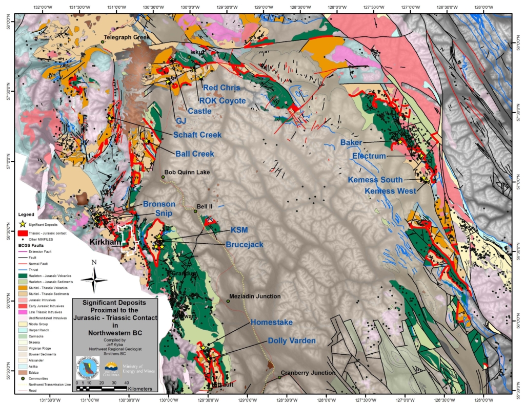
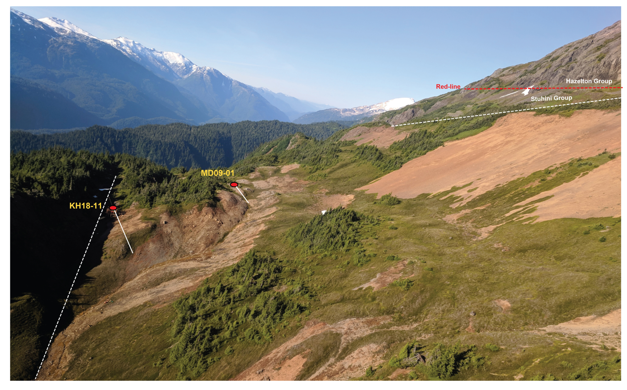
Cliff porphyry system lies on the southern end of the 7.5 km long Hawilson Monzonite (‘HM’) complex at Kirkham Property. Porphyry Cu-Au mineralization at Cliff is associated with a 200-500m wide and 3.5 km long, north-south trending corridor of Jurassic age (191 Ma) monzodiorite porphyry intrusions and breccias hosted by upper Triassic Stuhini Group rocks. The porphyry dikes and hydrothermal alteration footprint is proximate to the Triassic-Jurassic unconformity; referred to as the “Red Line” (Kyba 2014) recognized as an important geological horizon for copper-gold deposits in the Golden Triangle. The geological framework and metallogeny of the Cliff porphyry system is similar to the Kerr Deposit of Seabridge Gold’s KSM project, which has an inferred resource of 1.92 billion tonnes grading 0.41% copper and 0.31 g/t gold, containing 19.0 million ounces of gold and 17.3 billion pounds of copper (Seabridge New Release Feb 16, 2017).
Lithology and Alteration
Multiphase monzodiorite dikes at Cliff are cut by monzodiorite breccia and feldspar porphyry intrusions, displaying variable proportion of plagioclase feldspars and amphiboles, hydrothermal biotite, chlorite-sericite (clay) alteration minerals. The porphyry intrusions and breccias exhibit pervasive sericitic, and, locally preserved, potassic alteration along with a network of quartz-carbonate veins and disseminated to veinlet pyrite ± pyrrhotite ± chalcopyrite mineralization. The early mineralized porphyry intrusions and breccias are subsequently cut by typically narrow 1-4 m thick barren diorite and mafic dikes.
Structural Setting and Control of Mineralization
The 2019 exploration and drilling program confirmed a very strong structural control of mineralization in Cliff, Miles, and Nina porphyry systems along the Hawilson Monzonite complex. Mineralization tends to occur in both hanging and footwall of the northerly trending Adam fault system, leading to two sub-parallel zones of potassic alteration and Cu-Au mineralization along monzodiorite porphyry intrusions. Elevated gold-grades ranging from 1 to 14 g/t Au are commonly associated with a network of quartz-carbonate-sulphide veins constrained along NW-trending, syn-mineral conjugate faults. The intensity of alteration, veins and chalcopyrite-pyrite ratios and Cu grades increases with depth; a key vector towards a high-temperature potassic core in the porphyry systems. The drilling data provided valuable information to reconstruct the anatomy of faults, porphyry intrusions and alteration patterns, vectoring toward the core zones of the Cliff porphyry system, which may have a vertical extent of approximately 1000m.
COLE PORPHYRY SYSTEM
Overview
Location: 399483 E, 6263158 N
Mineral Deposit Type: Porphyry / Epithermal
Commodity: Gold-Copper-Silver
Size: 1000 x 800m Sericitic Alteration and Geochemical Anomaly
Exploration Completed: Remote Sensing, Mapping, Sampling, VTEM Surveys and Drilling (3,536m)
Planned Work: Detailed Mapping, IP Survey and Drilling
Geological Framework
The Cole Porphyry system defines the northern extent of the 7.5 km long Hawilson Monzonite (‘HM’) Complex near the Triassic-Jurassic unconformity at Kirkham property. The Cole porphyry system was first mapped in 2017 where Metallis’ geologists outlined a 500m x 200m wide zone of intense sericitic alteration and porphyry style mineralization in multiple crosscutting monzodiorite and diorite intrusions. These intrusions are emplaced as NNE-trending (015º) linear dikes hosted by Stuhini andesitic and clastic sedimentary rocks and unconformably overlain by Hazelton rocks to the west. The first drilling at the Cole target in 2018 intersected multiple cm-scale gold-bearing massive sulphide veins highlighted by 137 g/t Au over 0.6 meters, similar to the gold-bearing veins found at the Snip mine, which produced 1.1 million ounces of gold at an average grade of 27.5 g/t from 1991 to 1999. (MINFILE, 2015: Snip, 104B 250; BC Ministry of Energy and Mines).
Lithology and Alteration
Field mapping, drilling and petrographic analysis identified Cole as a typical sub-alkalic porphyry copper-gold system with an alteration footprint of 1000 x 800 meters. Porphyry copper-gold mineralization is associated with a series of northerly trending monzodiorite dikes cut by syn-mineral diorite and breccias and late-stage barren diorite dikes. The mapping indicated a zonal pattern of proximal sericitic alteration (QSP), medial Chlorite-Sericite alteration (SC) and peripheral propylitic (chlorite-epidote-carbonate) alteration. The gossan, within the sericitic alteration zone is characterized by pervasive and boxwork hematite-jarosite-limonite ± Manganese and green copper oxide minerals. The historic surface rock samples with 0.2-0.9% Cu and soils with 300 to >600 ppm Cu and 100-500 ppb Au correlate with the sericitic (QSP) alteration and veins in monzodiorite porphyry intrusions. The contact zones of the HM and syn-mineral diorite and feldspar porphyry dikes commonly represents abundant mm-scale scale quartz-carbonate-sulphide veins with gold-rich mineralization. The Cole porphyry system transition outward into gold bearing pyrite-pyrrhotite and epithermal style sheeted quartz veins near Etta area.
Structural Setting and Control of Mineralization
Field mapping and 3D geological modeling identified a distinct N15oE trending fault; referred to as the “Adam Fault” recognized as the main control of monzodiorite intrusions and gold-bearing quartz-sulphide veins at Cole porphyry system. Scattered outcrops of sheeted quartz-calcite and quartz-calcite-sulphide veins were mapped further to the west at Etta target near the Triassic-Jurassic unconformity. These veins are tabular in nature and constrained along sub-vertical faults within Hazelton Group sedimentary rocks. Mapping and drill core logging has illustrated linear sub-parallel porphyry intrusions and dikes striking N15°E and dipping ~60° to the east. This tabular geometry of the Cole porphyry dike swarm reflects the characteristics of the outer shell (“Carapace”) of a calc-alkaline porphyry system, which suggest that the untested areas are open both laterally and vertically.
Etta Epithermal System
The Etta epithermal system occurs immediately to the west of the Cole porphyry system near the Triassic-Jurassic, Red Line unconformity (Nelson and Kyba, 2014). Metallis’ exploration team in 2018 identified a narrow NS-trending zones of gold-bearing sheeted epithermal quartz and quartz-carbonate-sulphide veins in Hazelton Group rocks. These veins are temporally and spatially related to the Cole porphyry system to the east. The cm-scale, drusy textured quartz-calcite veins remains open along strike. The tabular sheeted quartz veins at Etta are characterized by drusy textures and exhibit typical gold pathfinder mineralogy typical of epithermal systems. These epithermal veins are responsible for the geochemical gold anomalies of over 1.0 g/t Au assayed in rocks. The field mapping and drilling results established that scattered epithermal veins in Etta are hosted within the propylitic altered sedimentary rocks of the Hazelton Group, which highlight the outer shell of the Cole porphyry system to be tested at deeper levels.
Exploration Targets
The Cole porphyry system was first mapped in detail during the 2017 exploration program, when Metallis geologists outlined a 500 x 300m wide zone of sericitic alteration and gossans that had never been drilled. The 2018 exploration program identified the Cole Complex as a typical sub-alkalic porphyry copper-gold system with an alteration footprint extending for 1000 x 800 meters. Metallis’ first-ever drilling campaign at the Cole discovered a series of NS-trending mineralized porphyry dikes, hydrothermal breccias and massive sulphide veins cutting across the volcano-sedimentary rocks of Stuhini Group formation.
The 2018 drilling assays at the Cole target indicated a high-grade gold zone containing 11.18 g/t Au over 7.7m including 137 g/t Au over 0.6m. The cm-scale massive sulphide veins in both KH18-18 and KH18-19 drill holes appear similar to the gold-bearing veins found in Snip mine. These mineralized veins exhibit a classic suite of elevated epithermal gold pathfinder elements such as As, Ag, Bi, Sb, Se, and Te, which suggest an outer shell (“Carapace”) of Cole porphyry system. Field mapping and 3D geological modelling has illustrated multiple sub-parallel porphyry intrusions striking N15°E and dips ~60° to the east demonstrating that untested areas are open laterally and vertically. 2018 Drilling Highlights
The 2018 drilling program intersected both porphyry and epithermal style mineralization. Drill hole KH18-18 intersected a series of up to 10m-thick monzodiorite intrusions and stock work quartz-carbonate-sulphide zones carrying elevated gold mineralization ranging from 0.4 to 0.94 g/t Au.
The high-grade gold intercept of 11.18 g/t Au over 7.7m including 137 g/t Au over 0.6m in KH18-19 is associated with shallow, intrusion-related massive sulphide veins. These veins transition outward into epithermal sheeted veins located at the Etta target to the west. (MTS New Release – Nov 20, 2018). Drill hole KH18-20 was drilled along and across the Adam fault cutting through a series of 4-9m gold intercepts ranging from 0.40 to 0.74 g/t AuEq, associated with similar centimeter-scale massive sulphide veins as in KH18-19. The surface geology, alteration patterns and geophysical signatures at Cole target vector towards a deeper mineralized system off to the southeast. 2019 Drilling Highlights Building on 2018’s high-grade drill intercept of 137 g/t Au over 0.6m, in 2019, the exploration team outlined a 1 km long by 200m wide zone of NE oriented faults and epithermal veins along the Cole porphyry system. Over 200 continuous rock-chip samples were collected from 21 trenches hand-excavated along the historic copper and gold geochemical anomalies. Several 2m intervals of continuous trench samples assayed anomalous gold ranging from 0.5 g/t to 1.25 g/t Au in the Cole porphyry system.
The 2019 program was designed to test the continuity of epithermal high-grade gold and porphyry copper-gold mineralization at the Cole Target. Six drill holes totaling 2,235m were drilled to test the porphyry-epithermal transition at the Cole Porphyry system, including the nearby Etta target. The drilling highlights are as follows:
• High-grade gold intervals ranging from 1.34 g/t AuEq* to 2.85 g/t AuEq* in the 2019 drill holes (See Table 1) along with the 137 g/t in KH18-19 from the 2018 program (MTS News Release Nov 29, 2018), have now confirmed the presence of multiple sub-parallel epithermal gold zones along the Adam fault;
• The broad drilling intercepts with up to 0.47 g/t AuEq* (See Table 1) correlate with pervasive green and grey sericitic altered and silicified monzonite dikes highlighting the strong potential of substantial porphyry-type mineralization at depth;
• Remnants of hydrothermal magnetite identified in holes KH19-31 and KH19-33 are now believed to be linked to a very large (2 km x 2 km) magnetic anomaly at the King East target, coincident with low resistivity and anomalous Cu, Au and Mo from soil and rock samples from previous programs.
Drill holes KH19-31 and KH19-33 tested a magnetic anomaly on the eastern fringe of the Cole porphyry system. The disseminated pyrrhotite and magnetite in KH19-31 appear to be the source of mag anomaly, whereas, KH19-33 intersected a section of mineralized monzonite with hydrothermal biotite and magnetite. This magnetic feature is probably linked to the King East target, which represents a very large coincident magnetic-high and resistivity-low anomaly extending over an area of 2 x 2 km. The calculated vertical gradient (‘CVG”) magnetic data show multiple north-south trending magnetic lineaments at King East, which reflect the structurally controlled intrusions propagated between Cole and King East targets. The exploration efforts will aim to test the copper-gold mineralization in both the high and low magnetic responses.
Exploration Potential
The exploration and drilling results to date established that the Cole target is a structurally controlled porphyry system transitioning westward into epithermal gold veins. Multiple sub-parallel porphyry intrusions and hydrothermal breccia bodies along faults result in an extensive (800m x 300m) footprint of sericitic alteration including a linear (300m x 50m) zone and gold-bearing pyrrhotite-pyrite and quartz-carbonate veins. These linear zones are characterized by intense quartz stock work, disseminations, and veins of pyrite + pyrrhotite ± chalcopyrite and 0.35 to 1.0 g/t gold mineralization and subsequently cut by swarm of late-mineral barren dikes.
Mineralization including 1.34 g/t AuEq* to 2.85 g/t AuEq* in the 2019 drill holes and 137 g/t Au in KH18-19 assayed from the 2018 program (MTS News Release Nov 2018), confirmed the emplacement of multiple sub-parallel epithermal gold veins along the Adam fault. These veins mainly occur along the footwall of the Adam fault and remain open at depth and to the south. The on-going advanced porphyry vectoring and fertility tools (“PVFT”) coupled with field observations and drill logs suggest both porphyry copper-gold and epithermal-type gold potential at Cole target.
Results from the field mapping and drill data has provided significant information to reconstruct the anatomy of faults, porphyry intrusions and alteration patterns. These features commonly vector toward the core zones of the Cole porphyry system, which may have a vertical extent of approximately 1,000m. The drilling assays provided a much better understanding of the control of mineralization. Metallis’ technical team is planning a strategic exploration and drilling program, supported by IP survey, that will test the expansion of near surface epithermal gold mineralization whilst simultaneously targeting the deeper core zones of the Cole porphyry system.
KING EAST
Overview
Location: 401247 E - 6261529 N
Mineral Deposit Type: Porphyry, Shear Vein
Commodity: Copper-Gold (Moly)
Size: 2km x 2km coincident Magnetic and Resistivity Anomaly, Anomalous Cu. Au, Mo
Exploration Completed:WV3 Remote Sensing, Sampling (soil-rock-trench), VTEM Surveys
Planned Work: Detailed Mapping, Grid sampling and drilling
Geological Framework
King East target represents a large (2 x 2km) coincident magnetic and resistivity anomaly overlapped with scattered zones of sericitic alteration within the upper Triassic Stuhini Group rocks. Previous work discovered numerous narrow gold-bearing veins, small intrusive stocks and anomalous Au, Cu and Mo anomalies from sub-crop and trenches in the area. The intrusive rocks include 1-4m wide diorite dikes and amygdaloidal to aphanitic intermediate intrusive stock as exposed to the south of King Creek (Howson, 1990a). In 2018 Metallis geologists mapped NNE-trending diorite porphyry dikes; recognized as the potential source of anomalous Cu and Mo in soils. The rock grab samples collected from porphyritic units and sulphide rich sediments also returned slightly anomalous Cu and Au mineralization.
The calculated vertical gradient (‘CVG”) magnetic image (see below) shows multiple north-south trending magnetic lineaments at King East, which reflect the structurally controlled porphyry intrusions and dikes propagated between the Cole and King East targets. The geology and structural framework, diorite dikes and its geochemical signature in King East is similar to what is seen in the Hawilson Monzonite. Remnants of hydrothermal magnetite identified in the Cole drill holes are also interpreted to be linked to King East magnetic anomaly. The current interpretation of the geology and alteration, geophysical and geochemical patterns identify King East as a deep-seated porphyry copper-gold target, similar to Seabridge’s deep Kerr (Sara Howson, 1991, Rosset, 2010) and Johnny Mountain porphyry targets.
Stratigraphic Sequence
Field mapping and petrographic studies (Howson, 1990) indicated extensive exposures of upper Triassic Stuhini volcano-sedimentary rocks overlain by intermediate to mafic volcaniclastics and mafic flows of the Unuk River Formation. The stratigraphy is predominantly covered by thick vegetation, however some of the outcrops along creeks reflects thinly bedded, dark-grey to black argillite, cherty argillite, light to dark greenish-green chert, light-grey siltstones, dark grey-green greywackes and finely laminated andesitic ash and crystal tuffs. These stratigraphic units strike north-south and dipping to the west and remain part of a broad north-plunging anticline with moderately dipping limbs (Britten et al., 1989). The Stuhini Group rocks at King East are cut by 0.5 to 4.0m thick porphyritic diorite dikes attributed to the Texas creek suite intrusions at Kirkham property.
Alteration and Mineralization
The porphyritic diorite dikes are apparently responsible for the silicification and chlorite alteration in the Stuhini Group rocks. The amygdaloidal to aphanitic intrusions display sericite-carbonate-pyrite and coarse-grained pyrrhotite assemblage. Historic mapping and prospecting reported that the interbedded chert, ash tuff and argillite units at King Creek are characterized by pervasive quartz-carbonate-limonite-sulphide alteration as part of the gossans which extends for 100m to the south of King Creek (Howson, 1990). This alteration assemblage and gossans corresponds to the outer sericitic alteration and oxidation in a porphyry system as observed in the Hawilson Monzonite complex to the west (see Fig. below)
 News
News  Market Data
  Discover