


Sunday, August 31, 2014 12:35:06 PM
 ) and proximity to current claims...
 from JABA's 1Q 1998 balance sheet:
Hay Mountain, Cochise County, Arizona
The Company holds 7 mineral exploration permits in this area comprising approximately 2,115 acres. On November 26, 1997, the Company signed a joint venture agreement with Phelps Dodge Exploration Corporation (?Phelps Dodge?) forming a limited liability company, Colina Mining, L.L.C. (?Colina?), to further develop this property. This joint venture was an amalgamation of the property held by the Company and 7 mineral exploration permits held by Phelps Dodge comprising approximately 2,560 acres. On March 27, 1998, Phelps Dodge withdrew from the Hay Mountain Joint Venture. Phelps Dodge will turn over all assets, including property and data to the Company.
digging around:
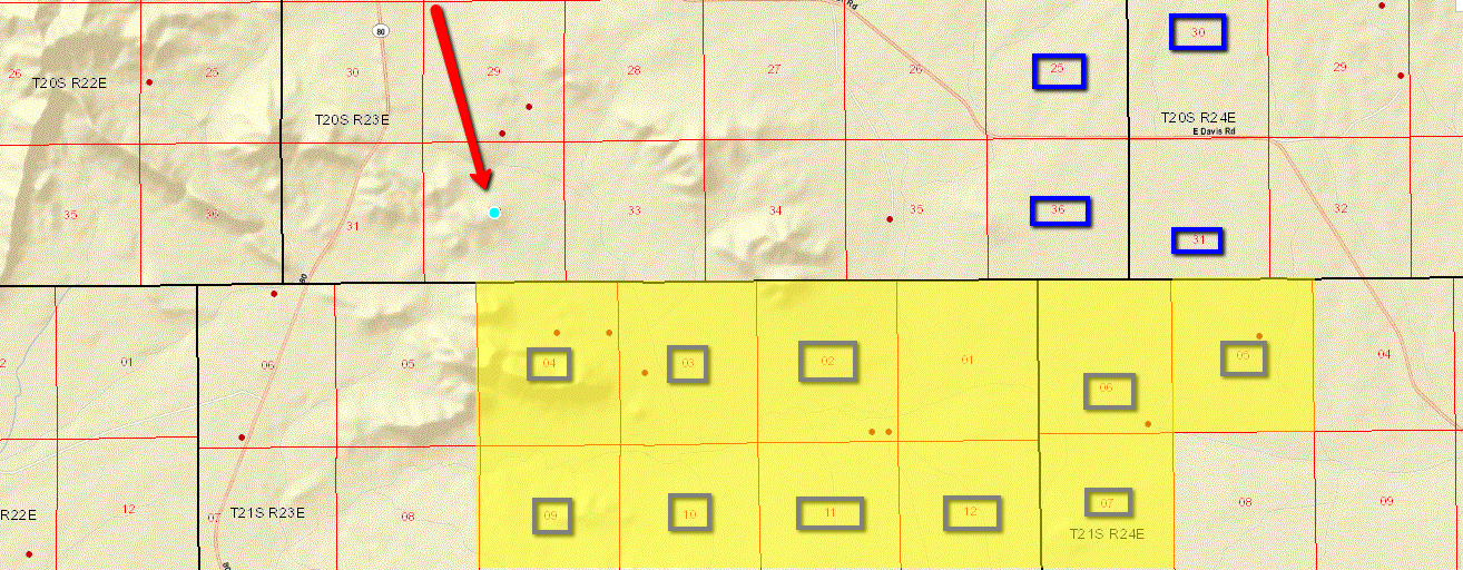
on this map---LBSR Hay Mt. claims are shaded in yellow---section #'s with a box around them have LBSR Arizona Mineral Exploration Permits on them...
note: T21S 23E S01 is private property...
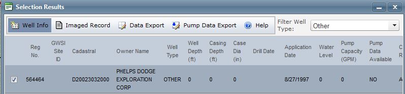
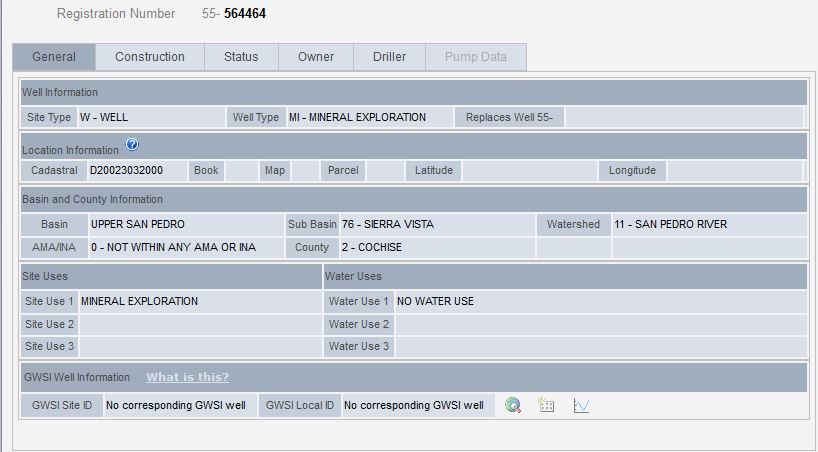
the BIG RED ARROW points to the location of the Phelps Dodge drill hole

Recent LBSR News
- Form 4 - Statement of changes in beneficial ownership of securities • Edgar (US Regulatory) • 02/26/2024 06:43:08 PM
- Form EFFECT - Notice of Effectiveness • Edgar (US Regulatory) • 02/23/2024 05:15:20 AM
- Form 8-K - Current report • Edgar (US Regulatory) • 02/15/2024 07:20:22 PM
- Form 8-K - Current report • Edgar (US Regulatory) • 02/13/2024 09:17:20 PM
- Form S-1/A - General form for registration of securities under the Securities Act of 1933: [Amend] • Edgar (US Regulatory) • 02/09/2024 08:57:35 PM
- Form 8-K - Current report • Edgar (US Regulatory) • 01/30/2024 10:19:05 PM
- Form 4 - Statement of changes in beneficial ownership of securities • Edgar (US Regulatory) • 01/24/2024 09:23:20 PM
- Form 4 - Statement of changes in beneficial ownership of securities • Edgar (US Regulatory) • 01/24/2024 09:21:30 PM
- Form 4 - Statement of changes in beneficial ownership of securities • Edgar (US Regulatory) • 01/24/2024 09:20:38 PM
- Form S-1/A - General form for registration of securities under the Securities Act of 1933: [Amend] • Edgar (US Regulatory) • 01/23/2024 06:41:06 PM
- Form S-1 - General form for registration of securities under the Securities Act of 1933 • Edgar (US Regulatory) • 12/22/2023 10:31:21 PM
- Form 10-Q - Quarterly report [Sections 13 or 15(d)] • Edgar (US Regulatory) • 12/15/2023 09:32:03 PM
- Form 4 - Statement of changes in beneficial ownership of securities • Edgar (US Regulatory) • 12/04/2023 11:11:03 AM
- Form 4 - Statement of changes in beneficial ownership of securities • Edgar (US Regulatory) • 12/04/2023 11:08:27 AM
- Form 4 - Statement of changes in beneficial ownership of securities • Edgar (US Regulatory) • 12/04/2023 11:07:51 AM
- Form 4 - Statement of changes in beneficial ownership of securities • Edgar (US Regulatory) • 12/04/2023 11:06:10 AM
- Form 8-K - Current report • Edgar (US Regulatory) • 12/01/2023 08:59:48 PM
- Form 8-K - Current report • Edgar (US Regulatory) • 11/22/2023 09:03:29 PM
- Form 8-K - Current report • Edgar (US Regulatory) • 11/15/2023 08:39:14 PM
- Form 4 - Statement of changes in beneficial ownership of securities • Edgar (US Regulatory) • 11/13/2023 11:17:10 AM
- Form DEF 14C - Other definitive information statements • Edgar (US Regulatory) • 10/31/2023 05:16:53 PM
- Form SC 13D/A - General statement of acquisition of beneficial ownership: [Amend] • Edgar (US Regulatory) • 10/31/2023 12:29:22 PM
- Form 4 - Statement of changes in beneficial ownership of securities • Edgar (US Regulatory) • 10/24/2023 07:32:36 PM
- Form 4 - Statement of changes in beneficial ownership of securities • Edgar (US Regulatory) • 10/19/2023 02:28:48 PM
North Bay Resources Announces Successful Equipment Test at Bishop Gold Mill, Inyo County, California • NBRI • Apr 23, 2024 9:41 AM
Epazz, Inc.: CryObo, Inc. solar Bitcoin operations will issue tokens • EPAZ • Apr 23, 2024 9:20 AM
Avant Technologies Launches Advanced AI Supercomputing Network and Expansive Data Solutions • AVAI • Apr 23, 2024 8:00 AM
BestGrowthStocks.com Issues Comprehensive Analysis of Triller Merger with AGBA Group Holding Limited • AGBA • Apr 22, 2024 1:00 PM
Cannabix Technologies to Present Marijuana Breathalyzer Technology at International Association for Chemical Testing (IACT) Conference in California • BLO • Apr 22, 2024 8:49 AM
Kona Gold Beverages, Inc. Prepares for First Production Run Set to Launch May 17, 2024 • KGKG • Apr 22, 2024 8:30 AM

